Manning, South Carolina

Last updated

Manning, South Carolina
Manning Commercial Historic District.jpg
The NRHP-listed Commercial Historic District in Manning.
Manning, SC City Seal.jpg
Motto: 
"Matchless For Beauty & Hospitality"
SCMap-doton-Manning.png
Coordinates: 33°41′42″N80°12′39″W / 33.69500°N 80.21083°W / 33.69500; -80.21083
Country United States
State South Carolina
County Clarendon
Government
  Type Mayor–council
   Mayor Julia A. Nelson
Area
[1]
  Total2.94 sq mi (7.60 km2)
  Land2.94 sq mi (7.60 km2)
  Water0.00 sq mi (0.00 km2)
Elevation
125 ft (38 m)
Population
 (2020) [2]
  Total3,878
  Density1,321.29/sq mi (510.17/km2)
Time zone UTC-5 (EST)
  Summer (DST) UTC-4 (EDT)
ZIP code
29102
Area code(s) 803, 839
FIPS code 45-44350 [3]
GNIS feature ID1231518 [4]
Website www.cityofmanning.org

Manning is a city in and the county seat of Clarendon County, South Carolina, United States. [5] The population was 3,245 as of the 2010 census, [6] with an estimated population in 2018 of 3,941. [7] It was named after former South Carolina governor John Laurence Manning. [8]

Contents

History

In 1855, the South Carolina Legislature appointed a group of commissioners to select and purchase a tract of land for "the Village of Manning" in the newly formed Clarendon County. According to the Watchmen, a local newspaper of the time, "the Legislature (had) granted a bill of divorce between Clarendon and Claremont (Sumter)."

Thirteen men were named as commissioners to select and acquire from 6 to 60 acres (2.4 to 24.3 ha) on which to lay out the new courthouse village: R. C. Baker, L. F. Rhame, J. C. Brock, W. W. Owens, Joseph Sprott, J. C. Burgess, M. T. Brogdon, J. J. Nelson, Samuel A. Burgess, J. J. McFadden, Jesse Hill, R. R. Haynsworth, and P. S. Worsham. Five other commissioners, R. I. Manning, L. F. Rhame, J. B. Brogdon, J. J. Conyers, and William A. Burgess, were later named when it came time to erect the courthouse and jail from a state appropriation of $18,000, plus whatever funds might be realized from the sale of lots. The site for the village was presented to the state by Captain Joseph Copley Burgess, and the Plat of Manning was prepared and filed in Sumter County Courthouse. (Captain Burgess had also donated land for the courthouse and jail in Manning.) On the second Monday of the following October, the new district officers were elected, and Clarendon began to operate independently from Sumter District with Manning as its county seat. [9]

The city was named for John Lawrence Manning, who was elected to both chambers in the General Assembly. He was later chosen by the Assembly to serve as Governor of South Carolina from 1852 to 1854. George Allen Huggins was the first intendant (mayor) of Manning.

Manning's Post Office was established in 1856, and Thomas S. Coogler was appointed as the first Postmaster. Manning's first library, the Hannah Levi Memorial Library, was completed in 1910. It was funded by the children of Moses and Hannah Levi, and by the sale of the Moses Levi Institute. They named it in honor of their mother. It eventually became known as the Manning Library and was the only public library in the county. It became a county library in 1976 and continued to operate until the opening of the Harvin Clarendon County Library in 1984. The building now houses the Clarendon County Archives and History Center. [10]

Manning was severely damaged several times over its history. A large portion of the original town, including the courthouse, was destroyed in the Civil War in 1865 during what is known as "Potter's Raid". This raid by Union troops took place only a few days before Gen. Robert E. Lee's surrender at Appomattox. Manning was later struck by a downtown fire in 1895 and damaged by a tornado in 1915.

Pauline Clyburn, rehabilitation client, and her children stringing tobacco, photographed by Marion Post Wolcott (June 1939) Pauline Clyburn, rehabilitation client, and her children str... (3110573452).jpg
Pauline Clyburn, rehabilitation client, and her children stringing tobacco, photographed by Marion Post Wolcott (June 1939)

Railroads, abundant timber and diverse agriculture allowed Manning to flourish during the late 19th century and into the 20th century. In 1933, Highway 4 was changed to U.S. Route 301 and thanks in part to the efforts of Manning resident W. P. Legg,[ citation needed ] Manning and Clarendon County became a preferred route of the Washington to Florida motorist. Manning is along the I-95 corridor and attracts retirees looking for various recreational activities and mild climates.

As early as 1960 Manning was one of many towns across the South for the staging of peaceful Civil Rights demonstrations and sit-ins. Unlike in some other areas, the demonstrations in Manning occurred without significant incident, but helped belie the local media's message that black Carolinians accepted the status quo. Manning and the surrounding region was still adjusting to the decisions handed down in the Briggs v. Elliott and Brown v. Board of Education rulings against racial segregation in schools. [11]

In 1969 Pansy Ridgeway became the first woman to be elected mayor of Manning. [12] She served as mayor of Manning from 1970 to 1996 and was the third woman elected mayor in South Carolina and the first woman elected president of the South Carolina Municipal Association.

On April 5, 2022, an EF2 tornado caused considerable damage on the western and northwestern sides of towns. Many homes, businesses, garages, trees, power poles and lines, and vehicles were damaged, some heavily. [13] [14]

Government

The city government consists of a mayor and a city council. The mayor is elected at-large, and the council consists of six members who are elected from each of six districts. [15]

Manning is represented in the South Carolina Senate by Kevin L. Johnson. It is part of South Carolina's 6th congressional district which since January 1993 has been represented by Jim Clyburn.

Media

Manning is home to The Manning Times [16] newspaper. It is published weekly and is updated online daily.

Education

Manning maintained school systems, one for black students and one for whites until court-ordered integration caused Manning Training School (for blacks) to merge with all white Manning High School in 1970. At that time, Manning Training School became Manning Middle School, then later Manning Elementary. In response, a private school, Laurence Manning Academy was created. [17] Manning is also the location of the F.E. DuBose Campus of Central Carolina Technical College. [18]

Manning has a lending library, the Clarendon County Public Library. [19]

Geography

Manning is located near the center of Clarendon County at 33°41′38″N80°12′55″W / 33.69389°N 80.21528°W / 33.69389; -80.21528 (33.693998, -80.215408). [20] It is just to the east of Interstate 95 and at the intersection of U.S. 301 and U.S. 521. Via I-95 it is 48 miles (77 km) northeast to Florence and 35 miles (56 km) southwest to Interstate 26. US 301 leads northeast 18 miles (29 km) to Turbeville and southwest 10 miles (16 km) to Summerton, while US 521 leads northwest 19 miles (31 km) to Sumter and southeast 15 miles (24 km) to Greeleyville.

According to the United States Census Bureau, Manning has a total area of 2.76 square miles (7.15 km2), all land. [6] It is just south of the Pocotaligo River, a tributary of the Black River.

Adjacent counties

Demographics

Historical population
CensusPop.Note
1890 1,069
1900 1,43033.8%
1910 1,85429.7%
1920 2,0229.1%
1930 1,884−6.8%
1940 2,38126.4%
1950 2,77516.5%
1960 3,91741.2%
1970 4,0252.8%
1980 4,74617.9%
1990 4,428−6.7%
2000 4,025−9.1%
2010 4,1082.1%
2020 3,878−5.6%
U.S. Decennial Census [21] [2]

2020 census

Manning Racial Composition [22]
RaceNum.Perc.
White 1,12028.88%
Black or African American 2,48664.11%
Native American 150.39%
Asian 701.81%
Other/Mixed 1022.63%
Hispanic or Latino 852.19%

As of the 2020 United States Census, there were 3,878 people, 1,485 households, and 1,036 families residing in the city.

2000 census

As of the census [3] of 2000, there were 4,025 people, 1,550 households, and 1,063 families residing in the city. The population density was 1,671.1 inhabitants per square mile (645.2/km2). There were 1,727 housing units at an average density of 717.0 per square mile (276.8/km2). The racial makeup of the city was 62.36% African American, 35.80% White, 0.62% Asian, 0.25% Native American, 0.07% Pacific Islander, 0.40% from other races, and 0.50% from two or more races. Hispanic or Latino of any race were 1.04% of the population.

There were 1,550 households, out of which 31.9% had children under the age of 18 living with them, 35.3% were married couples living together, 29.2% had a female householder with no husband present, and 31.4% were non-families. 29.4% of all households were made up of individuals, and 14.5% had someone living alone who was 65 years of age or older. The average household size was 2.52 and the average family size was 3.10.

In the city, the population was spread out, with 27.8% under the age of 18, 9.2% from 18 to 24, 24.7% from 25 to 44, 21.8% from 45 to 64, and 16.4% who were 65 years of age or older. The median age was 36 years. For every 100 females, there were 80.4 males. For every 100 females age 18 and over, there were 72.4 males.

The median income for a household in the city was $22,483, and the median income for a family was $26,269. Males had a median income of $26,135 versus $19,086 for females. The per capita income for the city was $11,502. About 23.8% of families and 30.1% of the population were below the poverty line, including 38.5% of those under age 18 and 20.3% of those age 65 or over. [23]

Notable people

Related Research Articles

<span class="mw-page-title-main">Pickens County, Alabama</span> County in Alabama, United States

Pickens County is a county located on the west central border of the U.S. state of Alabama. As of the 2020 census, the population was 19,123. Its county seat is Carrollton, located in the center of the county. It is a prohibition, or dry county, although the communities of Carrollton and Aliceville voted to become wet in 2011 and 2012, respectively.

<span class="mw-page-title-main">Sumter County, South Carolina</span> County in South Carolina, United States

Sumter County is a county located in the U.S. state of South Carolina. As of the 2020 census, the population was 105,556. Its county seat is Sumter.

<span class="mw-page-title-main">Florence County, South Carolina</span> County in South Carolina, United States

Florence County is a county located in the U.S. state of South Carolina. As of the 2020 census, its population was 137,059. Its county seat is Florence.

<span class="mw-page-title-main">Fairfield County, South Carolina</span> County in South Carolina, United States

Fairfield County is a county located in the U.S. state of South Carolina. As of the 2020 census, its population was 20,948. Its county seat is Winnsboro.

<span class="mw-page-title-main">Clarendon County, South Carolina</span> County in South Carolina, United States

Clarendon County is a county located below the fall line in the Coastal Plain region of U.S. state of South Carolina. As of 2020 census, its population was 31,144. Its county seat is Manning.

<span class="mw-page-title-main">Rutherford County, North Carolina</span> County in North Carolina, United States

Rutherford County is a county in the southwestern area of the U.S. state of North Carolina. As of the 2020 census, the population was 64,444. Its county seat is Rutherfordton. Rutherford County comprises the Forest City, NC Micropolitan Statistical Area.

<span class="mw-page-title-main">Americus, Georgia</span> City in Georgia, United States

Americus is the county seat of Sumter County, Georgia, United States. As of the 2020 census, the city had a population of 16,230. It is the principal city of the Americus Micropolitan Statistical Area, a micropolitan area that covers Schley and Sumter counties and had a combined population of 36,966 at the 2000 census.

<span class="mw-page-title-main">Wentworth, North Carolina</span> Town in North Carolina, United States

Wentworth is a town in Rockingham County, North Carolina, United States. The population was 2,646 at the 2020 census. Wentworth is the county seat of Rockingham County and is part of the Greensboro–High Point metropolitan area of the Piedmont Triad. On May 6, 2022, an EF-1 Tornado hit Wentworth. The storm traveled as a supercell with crazy structure from the Pilot Mountain, North Carolina, and Pinnacle, North Carolina, area across central Stokes County and into Rockingham County. It took out trees, damaged homes, and blocked roads before it lifted off southwest of Reidsville.

<span class="mw-page-title-main">Allendale, South Carolina</span> Town in South Carolina, United States

Allendale is a town in and the county seat of Allendale County, South Carolina, United States. The population was 3,482 at the 2010 census, a decline from 4,052 in 2000.

<span class="mw-page-title-main">Paxville, South Carolina</span> Town in South Carolina, United States

Paxville is a town in Clarendon County, South Carolina, United States. The population was 185 at the 2010 census, down from 248 in 2000. The town was named after Joseph Pack.

<span class="mw-page-title-main">Summerton, South Carolina</span> Town in South Carolina, United States

Summerton is a town in Clarendon County, South Carolina, United States. Per the 2020 census, the population was 814.

<span class="mw-page-title-main">Turbeville, South Carolina</span> Town in South Carolina, United States

Turbeville is a town in Clarendon County, South Carolina, United States. The population was 766 at the 2010 census, up from 602 in 2000.

<span class="mw-page-title-main">Lamar, South Carolina</span> Town in South Carolina, United States

Lamar is a town in Darlington County, South Carolina, United States. The population was 989 at the 2010 census. It is part of the Florence, SC Metropolitan Statistical Area.

<span class="mw-page-title-main">Lake City, South Carolina</span> City in South Carolina, United States

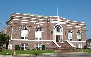
Lake City is a city in Florence County, South Carolina, United States. The population was 6,675 at the 2010 census. Located in central South Carolina, it is south of Florence and included as part of the Florence Metropolitan Statistical Area.

<span class="mw-page-title-main">Lancaster, South Carolina</span> City in South Carolina, United States

The city of Lancaster is the county seat of Lancaster County, South Carolina, United States, located in the Charlotte Metropolitan Area. As of the United States Census of 2010, the city population was 8,526. The city was named after the famous House of Lancaster.

<span class="mw-page-title-main">Lexington, South Carolina</span> Town in South Carolina, USA

Lexington is the most populous town in and the county seat of Lexington County, South Carolina, United States. It is a suburb of the state capital, Columbia. The population was 23,568 at the 2020 Census, and it is the second-most populous municipality in the greater Columbia area. The 2022 estimated population is 24,626. According to the Central Midlands Council of Governments, the greater Lexington area had an estimated population of 111,549 in 2020 and is considered the fastest-growing area in the Midlands. Lexington's town limits are bordered to the east by the city of West Columbia.

<span class="mw-page-title-main">Bennettsville, South Carolina</span> City in South Carolina, United States

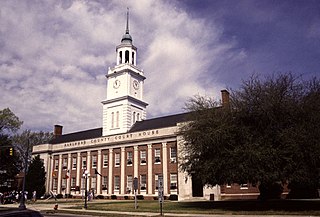
Bennettsville is a city located in the U.S. state of South Carolina on the Great Pee Dee River. As the county seat of Marlboro County, Bennettsville is noted for its historic homes and buildings from the 19th and early 20th centuries—including the Bennettsville Historic District which is listed on the National Register of Historic Places.

<span class="mw-page-title-main">Sumter, South Carolina</span> City in Sumter County, South Carolina, United States

Sumter is a city in and the county seat of Sumter County, South Carolina, United States. The city makes up the Sumter, SC Metropolitan Statistical Area. Sumter County, along with Clarendon and Lee counties, form the core of Sumter–Lee–Clarendon tri-county area of South Carolina that includes three counties straddling the border of the Sandhills, Pee Dee, and Lowcountry regions. The population was 43,463 at the 2020 census, making it the 9th-most populous city in the state.

<span class="mw-page-title-main">Franklin, Texas</span> City in Texas, United States

Franklin is a city in, and the county seat of, Robertson County, Texas, United States. It is within the Brazos Valley, on the cusp of the East and Central Texas regions. As of the 2020 census, the city population was 1,614. The original name of the town was Morgan and it was made county seat in 1879.

<span class="mw-page-title-main">Shinnston, West Virginia</span> City in West Virginia, United States

Shinnston is a city and former coal town in Harrison County, West Virginia, United States, along the West Fork River. In 1778, Levi Shinn constructed his log home along what is now Route 19; today it is the oldest standing structure in north-central West Virginia. As of the 2020 census, Shinnston had a population of 2,332.

References

  1. "ArcGIS REST Services Directory". United States Census Bureau. Retrieved October 15, 2022.
  2. 1 2 "Census Population API". United States Census Bureau. Retrieved October 15, 2022.
  3. 1 2 "U.S. Census website". United States Census Bureau . Retrieved January 31, 2008.
  4. "US Board on Geographic Names". United States Geological Survey. October 25, 2007. Retrieved January 31, 2008.
  5. "Find a County". National Association of Counties. Retrieved June 7, 2011.
  6. 1 2 "Geographic Identifiers: 2010 Census Summary File 1 (G001): Manning city, South Carolina". U.S. Census Bureau, American Factfinder. Archived from the original on February 13, 2020. Retrieved July 1, 2015.
  7. "Population and Housing Unit Estimates" . Retrieved October 22, 2019.
  8. "History of Manning". City of Manning. Retrieved September 22, 2007.
  9. Gregorie, Anne (1954). History of Sumter County. Sumter, South Carolina: Library Board of Sumter County. p. 232. LCCN   54010612.
  10. "Hannah Levi Memorial Library / Manning Library Marker - Historic Markers Across South Carolina".
  11. Edgar, Walter (1998). South Carolina, A History. Columbia, SC: University of South Carolina. p. 536. ISBN   1-57003-255-6.
  12. Edgar, Walter (1998). South Carolina, A History. Columbia, SC: University of South Carolina. pp. 571–572. ISBN   1-57003-255-6.
  13. April 5th, 2022 Tornado Outbreak (Report). National Weather Service. National Weather Service in Columbia, South Carolina. April 7, 2022. Retrieved April 25, 2022.
  14. NWS Damage Survey for 04/05/22 Tornado Event (Report). Iowa Environmental Mesonet. National Weather Service in Columbia, South Carolina. April 6, 2022. Retrieved April 6, 2022.
  15. "Manning City Council". City of Manning. Archived from the original on April 16, 2010. Retrieved March 16, 2010.
  16. manninglive.com
  17. Baker, Robert Joseph (June 9, 2016). "Manning Training School alumni dedicate historic plaque" . Retrieved August 6, 2020.
  18. The F.E. DuBose Campus Archived 2010-05-27 at the Wayback Machine of Central Carolina Technical College
  19. "South Carolina libraries and archives". SCIWAY. Retrieved June 8, 2019.
  20. "US Gazetteer files: 2010, 2000, and 1990". United States Census Bureau. February 12, 2011. Retrieved April 23, 2011.
  21. "Census of Population and Housing". Census.gov. Retrieved June 4, 2015.
  22. "Explore Census Data". data.census.gov. Retrieved December 7, 2021.
  23. "Census Bureau data". Archived from the original on February 12, 2020.
  24. "Joseph O. Rogers, Jr., Papers" (PDF). library.sc.edu. Retrieved May 3, 2014.