Chesterfield, South Carolina

Last updated

Chesterfield, South Carolina
Mount Tabor United Methodist Church.jpg
Mount Tabor United Methodist Church, pictured in August 2012
Chesterfield, SC Town Seal.webp
Nickname: 
The Heart of the Carolinas
SCMap-doton-Chesterfield.PNG
Location of Chesterfield, South Carolina
Coordinates: 34°44′1″N80°5′20″W / 34.73361°N 80.08889°W / 34.73361; -80.08889
Country Flag of the United States.svg  United States
State Flag of South Carolina.svg  South Carolina
County Chesterfield flag.png Chesterfield
Area
[1]
  Total4.08 sq mi (10.56 km2)
  Land4.08 sq mi (10.56 km2)
  Water0.00 sq mi (0.00 km2)
Elevation
292 ft (89 m)
Population
 (2020) [2]
  Total1,357
  Density332.68/sq mi (128.45/km2)
Time zone UTC-5 (Eastern (EST))
  Summer (DST) UTC-4 (EDT)
ZIP code
29709
Area code(s) 843, 854
FIPS code 45-14140 [3]
GNIS feature ID1231164 [4]
Website chesterfield-sc.com

Chesterfield is a town in Chesterfield County, South Carolina, United States. The population was 1,472 at the 2010 census. [5] It is the county seat of Chesterfield County. [6] At the time of the 2010 census, Chesterfield was the least populous of all of South Carolina's county seats.

Contents

History

The East Main Street Historic District, Dr. Thomas E. Lucas House, and West Main Street Historic District are listed on the National Register of Historic Places, supervised by the National Park Service of the U.S. Department of the Interior. [7]

Geography

Chesterfield is located in northeastern Chesterfield County at 34°44′1″N80°5′20″W / 34.73361°N 80.08889°W / 34.73361; -80.08889 (34.733626, -80.088945). [8] According to the United States Census Bureau, the town has a total area of 4.1 square miles (10.5 km2), all land. [5]

South Carolina Highway 9 passes through the town, leading east 12 miles (19 km) to Cheraw and west 19 miles (31 km) to Pageland. South Carolina Highway 145 crosses SC 9 near the center of town, leading southwest 21 miles (34 km) to McBee and northeast 10 miles (16 km) to Morven, North Carolina. South Carolina Highway 102 leads south from Chesterfield 12 miles (19 km) to Patrick.

Demographics

Historical population
CensusPop.Note
1900 308
1910 618100.6%
1920 85638.5%
1930 1,03020.3%
1940 1,26322.6%
1950 1,53021.1%
1960 1,5320.1%
1970 1,6678.8%
1980 1,432−14.1%
1990 1,373−4.1%
2000 1,318−4.0%
2010 1,47211.7%
2020 1,357−7.8%
U.S. Decennial Census [2]

2020 census

Chesterfield racial composition [9]
RaceNum.Perc.
White (non-Hispanic)88265.0%
Black or African American (non-Hispanic)38428.3%
Native American 30.22%
Asian 60.44%
Other/Mixed 644.72%
Hispanic or Latino 181.33%

As of the 2020 United States census, there were 1,357 people, 571 households, and 406 families residing in the town.

2000 census

As of the census [3] of 2000, there were 1472 people, 597 households, and 358 families residing in the town. The population density was 383.2 inhabitants per square mile (148.0/km2). There were 683 housing units at an average density of 198.6 per square mile (76.7/km2). The racial makeup of the town was 64.64% White, 34.67% African American, 0.15% Native American, 0.09% Asian, 0.29% from other races, and 0.15% from two or more races. Hispanic or Latino of any race were 0.83% of the population.

There were 597 households, out of which 28.1% had children under the age of 18 living with them, 38.5% were married couples living together, 19.8% had a female householder with no husband present, and 39.9% were non-families. 37.2% of all households were made up of individuals, and 17.8% had someone living alone who was 65 years of age or older. The average household size was 2.19 and the average family size was 2.86.

In the town, the population was spread out, with 23.2% under the age of 18, 7.7% from 18 to 24, 25.7% from 25 to 44, 24.9% from 45 to 64, and 18.5% who were 65 years of age or older. The median age was 41 years. For every 100 females, there were 81.5 males. For every 100 females age 18 and over, there were 73.0 males.

The median income for a household in the town was $25,833, and the median income for a family was $36,806. Males had a median income of $31,488 versus $20,625 for females. The per capita income for the town was $16,481. About 19.7% of families and 23.7% of the population were below the poverty line, including 39.0% of those under age 18 and 22.2% of those age 65 or over.

Education

Chesterfield has a public library, a branch of the Chesterfield County Library System. [10]

Geology

The "great syenite dyke" extends from Hanging Rock through Taxahaw to the Brewer and Edgeworth mine in Chesterfield. [11]

See also

Related Research Articles

<span class="mw-page-title-main">Chesterfield, Massachusetts</span> Town in Massachusetts, United States

Chesterfield is a rural hill town in Hampshire County, Massachusetts, United States, 26 miles (42 km) east of Pittsfield and 90 miles (140 km) west of Boston. The population was 1,186 at the 2020 census. It is part of the Springfield, Massachusetts Metropolitan Statistical Area.

<span class="mw-page-title-main">Clarkton, North Carolina</span> Town in North Carolina, United States

Clarkton is a town in Bladen County, North Carolina, United States. The population was 837 at the 2010 census.

<span class="mw-page-title-main">Warsaw, North Carolina</span> Town in North Carolina, United States

Warsaw is a town in Duplin County, North Carolina, United States. The population was 3,054 at the 2010 census.

<span class="mw-page-title-main">Belton, South Carolina</span> City in South Carolina, United States

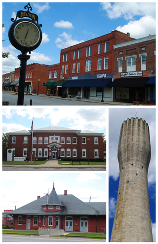
Belton is a city in eastern Anderson County, South Carolina. The population was 4,134 at the 2010 census.

<span class="mw-page-title-main">Olar, South Carolina</span> Town in South Carolina, United States

Olar is a town in Bamberg County, South Carolina, United States. The population was 257 at the 2010 census.

<span class="mw-page-title-main">St. Stephen, South Carolina</span> Town in South Carolina, United States

St. Stephen is a town in Berkeley County, South Carolina, United States. The population was 1,697 at the 2010 census.

<span class="mw-page-title-main">Great Falls, South Carolina</span> Town in South Carolina, United States

Great Falls is a town in Chester County, South Carolina, United States and is located fourteen miles southwest of Lancaster, South Carolina. The population was 1,951 at the 2020 census.

<span class="mw-page-title-main">Richburg, South Carolina</span> Town in South Carolina, United States

Richburg is a town in Chester County, South Carolina, United States. The population was 275 at the 2010 census, down from 332 at the 2000 census.

<span class="mw-page-title-main">Cheraw, South Carolina</span> Town in South Carolina, United States

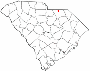
Cheraw is a town on the Pee Dee River in Chesterfield County, South Carolina, United States. The population was 5,040 at the 2020 census. The greater Cheraw area in the zip code 29520 has a population of 13,689 according to the 2019 ACS data. It has been nicknamed "The Prettiest Town in Dixie".

<span class="mw-page-title-main">Jefferson, South Carolina</span> Town in South Carolina, United States

Jefferson is a town in western Chesterfield County, South Carolina, United States at the junction of SC routes 265 and 151. Jefferson is located in the Piedmont region of South Carolina just in the edge meeting the Sandhills region. Jefferson is located 16 miles northwest of McBee, 8 miles south of Pageland, 50 miles southeast of Charlotte, North Carolina, and 70 miles north-northeast of the state capitol Columbia. As of the 2010 census, the city population was 753.

<span class="mw-page-title-main">McBee, South Carolina</span> Town in South Carolina, United States

McBee is a town in Chesterfield County, South Carolina, United States. As of the 2010 census, the population was 867. McBee is approximately 36 miles (58 km) northwest of Florence and 62 miles (100 km) northeast of Columbia.

<span class="mw-page-title-main">Mount Croghan, South Carolina</span> Town in South Carolina, United States

Mount Croghan is a town in Chesterfield County, South Carolina, United States. The population was 195 at the 2010 census, up from 155 in 2000. It houses a Flea market

<span class="mw-page-title-main">Pageland, South Carolina</span> Town in South Carolina, United States

Pageland is a town in Chesterfield County, South Carolina, United States. It is the second largest town in Chesterfield County. The population was 2,760 at the 2010 census.

<span class="mw-page-title-main">Patrick, South Carolina</span> Town in South Carolina, United States

Patrick is a town in Chesterfield County, South Carolina, United States. The population was 351 at the 2010 census.

<span class="mw-page-title-main">Ruby, South Carolina</span> Town in South Carolina, United States

Ruby is a town in Chesterfield County, South Carolina, United States. The population was 360 at the 2010 census.

<span class="mw-page-title-main">Summerton, South Carolina</span> Town in South Carolina, United States

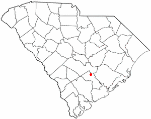
Summerton is a town in Clarendon County, South Carolina, United States. Per the 2020 census, the population was 814.

<span class="mw-page-title-main">Harleyville, South Carolina</span> Town in Dorchester County, South Carolina, United States

Harleyville is a town in Dorchester County, South Carolina, United States. The population was 677 at the 2010 census, up from 594 at the 2000 census. Harleyville is part of the Charleston-North Charleston-Summerville metropolitan area. As of 2018 the population is 696.

<span class="mw-page-title-main">Ridgeway, South Carolina</span> Town in South Carolina, United States

Ridgeway is a town in Fairfield County, South Carolina, United States. The population was 319 at the 2010 census. It is part of the Columbia, SC Metropolitan Statistical Area.

<span class="mw-page-title-main">Kershaw, South Carolina</span> Town in South Carolina, United States

Kershaw is a town in Lancaster County, South Carolina, United States. It was incorporated in 1888. As of the 2010 census, the population was 1,803, and as of 2019 the estimated population was 2,321. The Haile Gold Mine, where gold was discovered in 1825, is 3 miles (5 km) from town and was at one time the largest single producer of gold in the Appalachian region.

Harrells is a town in Duplin and Sampson counties, North Carolina, United States. The population was 160 at the 2020 census. At the previous census in 2010, the population was 202.

References

  1. "ArcGIS REST Services Directory". United States Census Bureau. Retrieved October 15, 2022.
  2. 1 2 "Census Population API". United States Census Bureau. Retrieved October 15, 2022.
  3. 1 2 "U.S. Census website". United States Census Bureau . Retrieved January 31, 2008.
  4. "US Board on Geographic Names". United States Geological Survey. October 25, 2007. Retrieved January 31, 2008.
  5. 1 2 "Geographic Identifiers: 2010 Census Summary File 1 (G001): Chesterfield town, South Carolina". U.S. Census Bureau, American Factfinder. Archived from the original on February 13, 2020. Retrieved July 1, 2015.
  6. "Find a County". National Association of Counties. Archived from the original on May 9, 2015. Retrieved June 7, 2011.
  7. "National Register Information System". National Register of Historic Places . National Park Service. July 9, 2010.
  8. "US Gazetteer files: 2010, 2000, and 1990". United States Census Bureau. February 12, 2011. Retrieved April 23, 2011.
  9. "Explore Census Data". data.census.gov. Retrieved December 15, 2021.
  10. "South Carolina libraries and archives". SCIWAY. Retrieved June 7, 2019.
  11. Lieber, Oscar Montgomery (1856). Report on the Survey of South Carolina. South Carolina General Assembly. p. 32. ISBN   9785880484188 . Retrieved December 2, 2014.