Seneca, South Carolina

Last updated

Seneca, South Carolina
Seneca South Carolina city hall.JPG
Seneca City Hall
Seneca, SC City Flag.gif
Seneca, SC City Seal.gif
Motto(s): 
"City of Smiles, City with Style"
Oconee County South Carolina incorporated and unincorporated areas Seneca highlighted.svg
Location in Oconee County and the state of South Carolina.
Coordinates: 34°41′3″N82°57′21″W / 34.68417°N 82.95583°W / 34.68417; -82.95583
CountryUnited States
State South Carolina
County Oconee
Government
  MayorDaniel W. Alexander
Area
[1]
  Total8.30 sq mi (21.49 km2)
  Land8.24 sq mi (21.35 km2)
  Water0.05 sq mi (0.14 km2)
Elevation
[2]
951 ft (290 m)
Population
 (2020) [3]
  Total8,850
  Density1,073.64/sq mi (414.55/km2)
Time zone UTC−5 (Eastern (EST))
  Summer (DST) UTC−4 (EDT)
ZIP codes
29672, 29678, 29679
Area code 864
FIPS code 45-65095 [4]
GNIS feature ID1250833 [2]
Website www.seneca.sc.us

Seneca is a city in Oconee County, South Carolina, United States. The population was 8,102 at the 2010 census. It is the principal city of the Seneca Micropolitan Statistical Area (population 74,273 at the 2010 census), an (MSA) that includes all of Oconee County, and that is included within the greater Greenville-Spartanburg-Anderson, South Carolina Combined Statistical Area (population 1,266,995 at the 2010 census). Seneca was named for the nearby Cherokee town of Isunigu, which English colonists knew as "Seneca Town".

Contents

History

Welcome sign Seneca SC welcome sign.JPG
Welcome sign

In the antebellum period, this area was part of the Pickens District, South Carolina. The state had used jurisdictions such as parish, county, district, and county again in its history. Oconee County was not organized until 1868, after the American Civil War.

Seneca was founded in 1873, during the Reconstruction era, as the railroad town "Seneca City", named for the Seneca River and a historic Cherokee town known as Isunigu. It was called Seneca in a kind of transliteration by British colonists.

Seneca City was developed at the intersection of the Blue Ridge Railroad and the newly built Atlanta and Charlotte Air Line Railroad. Both lines are now part of the Norfolk Southern Railway. A. W. Thompson and J. J. Norton, who were locating engineers for the Air Line Railroad, purchased the land from Col. Brown of Anderson, South Carolina, also in the large Pickens District. A stake marking the center of town was driven into the ground at the intersection of the railroad tracks and the current Townville Street. The land was divided into lots for a one-half mile from the stake. An auction was held on August 14, 1873. The town was given a charter by the state legislature on March 14, 1874. In 1908, the name was changed to the shorter Seneca.

Old Cotton Warehouse. The right hand section of the warehouse burned in April 2008 and has been torn down. Seneca Cotton Warehouse.jpg
Old Cotton Warehouse. The right hand section of the warehouse burned in April 2008 and has been torn down.

Seneca developed as a marketing and shipping point for cotton, the major commodity crop in this uplands area. During the harvest, wagons bringing cotton would line up for blocks from the railroad station. A passenger terminal, several hotels, and a park were built near the railroad tracks. Recently, this park was named the Norton-Thompson Park in honor of the city's founders.

The first school was built in 1874. The community also was home of the Seneca Institute - Seneca Junior College, established here in 1899 as an historically black college. It was reserved for African-American students until 1939.

Westpoint Stevens Plant, January 2008. Demolition of the mill began in the spring of 2008. WPSplant.jpg
Westpoint Stevens Plant, January 2008. Demolition of the mill began in the spring of 2008.

Textile mills were built in the area; a plant-and-mill village was built in 1893 by the Courtenay Manufacturing Company in Newry on the Little River, which supplied hydropower for the mill. W.L. Jordon built another textile plant and mill village east of Seneca. This village has been called Jordania, Londsdale, and Utica; these changes accompanied changes in ownership of the plant. The J. P. Stevens Plant, which was later called the Westpoint Stevens Plant, was a large textile mill built on Lake Hartwell. Its workforce was integrated, unlike most other plants that hired only whites. Many other textile mills were developed in this area. These plants were the main industry for Seneca for the first half of the twentieth century. With the shift of these jobs overseas, these textile mills are now closed.

In the late 20th century, major dam projects were constructed n the Keowee and other local rivers, to support recreation and public utilities. These projects created three major lakes: Lake Hartwell in 1963, Lake Keowee in 1971, and Lake Jocassee in 1974, stimulating development in Seneca and the region. Duke Power's Oconee Nuclear Station was built on Lake Keowee, drawing cooling water for its operations from the lake.

The recreation provided by the lakes, and other attractions, such as nearby Clemson University attracted many retirees from other parts of the country. Retirement communities have been built in the area. [5] Concerned about over-development, some residents formed the Friends of Lake Keowee Society (FOLKS) to advocate for balance. [6]

Early on April 13, 2020, a high-end EF3 tornado struck residential areas south and east of Seneca. Many buildings were damaged or destroyed and one person was killed. [7]

National Register of Historic Places listings

In and around Seneca, there are a number of historic buildings and districts that are on the National Register of Historic Places: [8]

Geography

Seneca is located at 34°41′3″N82°57′21″W / 34.68417°N 82.95583°W / 34.68417; -82.95583 (34.684145, -82.955778). [19]

According to the United States Census Bureau, the city has a total area of 7.1 square miles (18 km2), of which 7.1 square miles (18 km2) is land and 0.04 square miles (0.10 km2) (0.56%) is water.

Demographics

Historical population
CensusPop.Note
1880 382
1900 920
1910 1,31342.7%
1920 1,46011.2%
1930 1,92932.1%
1940 2,15511.7%
1950 3,64969.3%
1960 5,22743.2%
1970 6,02715.3%
1980 7,43623.4%
1990 7,7263.9%
2000 7,652−1.0%
2010 8,1025.9%
2020 8,8509.2%
U.S. Decennial Census [20]
2020 [3]

2020 census

Seneca racial composition [21]
RaceNum.Perc.
White (non-Hispanic)5,55662.78%
Black or African American (non-Hispanic)2,14324.21%
Native American 250.28%
Asian 1081.22%
Pacific Islander 30.03%
Other/Mixed 4845.47%
Hispanic or Latino 5316.0%

As of the 2020 United States census, there were 8,850 people, 4,043 households, and 2,138 families residing in the city.

2000 census

As of the census [4] of 2000, there were 7,652 people, 3,286 households, and 2,096 families residing in the city. The population density was 1,084.6 inhabitants per square mile (418.8/km2). There were 3,677 housing units at an average density of 521.2 per square mile (201.2/km2). The racial makeup of the city was 63.32% White, 33.77% African American, 0.31% Native American, 0.63% Asian, 0.01% Pacific Islander, 0.65% from other races, and 1.31% from two or more races. Hispanic or Latino of any race were 1.53% of the population.

There were 3,286 households, out of which 27.4% had children under the age of 18 living with them, 42.2% were married couples living together, 17.5% had a female householder with no husband present, and 36.2% were non-families. Of all households 32.3% were made up of individuals, and 13.2% had someone living alone who was 65 years of age or older. The average household size was 2.32 and the average family size was 2.93.

In the city, the population was spread out, with 24.4% under the age of 18, 9.5% from 18 to 24, 25.3% from 25 to 44, 24.7% from 45 to 64, and 16.0% who were 65 years of age or older. The median age was 38 years. For every 100 females, there were 87.5 males. For every 100 females age 18 and over, there were 83.0 males.

The median income for a household in the city was $32,643, and the median income for a family was $44,487. Males had a median income of $31,381 versus $21,472 for females. The per capita income for the city was $18,498. About 13.0% of families and 15.6% of the population were below the poverty line, including 23.0% of those under age 18 and 16.4% of those age 65 or over.

Government

Seneca City Hall is located on North First Street, in the center of the historic (downtown) area of Seneca. North First Street is also marked as Highway 123 Business. The City Hall Complex holds the Seneca Police Dept, Seneca Light and Water, as well as the offices of the Mayor and City Administrator.

Seneca Fire Department is housed on West South Fourth Street, in a new complex. The Fire House is just across the street from the Shaver Complex, which comprises the Shaver Civic Center, sports fields for the Seneca Recreation Department, a park for smaller children, and a rubberized soft walking track.

Education

Seneca has a lending library, a branch of the Oconee County Public Library. [22]

Until June 2020, it was the headquarters of the National Council of Examiners for Engineering and Surveying (NCEES), the council that deals with the examination for engineers and surveyors. On that date, the NCEES moved to Greenville, South Carolina.

Notable people

See also

Related Research Articles

<span class="mw-page-title-main">Pickens County, South Carolina</span> County in South Carolina, United States

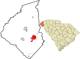
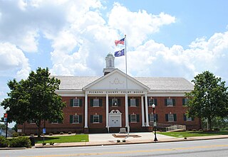
Pickens County is located in the northwest part of the U.S. state of South Carolina. As of the 2020 census, its population was 131,404. Its county seat is Pickens. The county was created in 1826. It is part of the Greenville-Anderson-Greer, SC Metropolitan Statistical Area.

<span class="mw-page-title-main">Oconee County, South Carolina</span> County in South Carolina, United States

Oconee County is the westernmost county in the U.S. state of South Carolina. As of the 2020 census, the population was 78,607. Its county seat is Walhalla and its largest community is Seneca. Oconee County is included in the Seneca, SC Micropolitan Statistical Area, which is also included in the Greenville-Spartanburg-Anderson, SC Combined Statistical Area. South Carolina Highway 11, the Cherokee Foothills National Scenic Highway, begins in southern Oconee County at Interstate Highway 85 at the Georgia state line.

<span class="mw-page-title-main">Greenwood County, South Carolina</span> County in South Carolina, United States

Greenwood County is a county located in the U.S. state of South Carolina. As of the 2020 census, its population was 69,351. Its county seat is Greenwood.

<span class="mw-page-title-main">Anderson County, South Carolina</span> County in South Carolina, United States

Anderson County is a county located in the U.S. state of South Carolina. As of the 2020 census, its population was 203,718. Its county seat is Anderson. Named for Revolutionary War leader Robert Anderson, the county is located in northwestern South Carolina, along the state line of Georgia. Anderson County is included in the Greenville-Anderson-Greer, SC Metropolitan Statistical Area. Anderson County contains 55,950-acre (22,640 ha) Lake Hartwell, a U.S. Army Corps of Engineers lake with nearly 1,000 miles (1,600 km) of shoreline for residential and recreational use. The area is a growing industrial, commercial and tourist center. It is the home of Anderson University, a private, selective comprehensive university of approximately 4,000 undergraduate and graduate students.

<span class="mw-page-title-main">Belmont, North Carolina</span> City in North Carolina, United States

Belmont is a small suburban city in Gaston County, North Carolina, United States, located about 9 miles (14 km) east of Gastonia. The population was 10,076 at the 2010 census. Once known as Garibaldi Station, it was named for the New York banker August Belmont. Belmont is home to Belmont Abbey College.

<span class="mw-page-title-main">Mount Holly, North Carolina</span> City in North Carolina, United States

Mount Holly is a small suburban city in northeastern Gaston County, North Carolina, United States. The city is situated just west of the Catawba River, north of Interstate 85, south of North Carolina State Highway 16. The population was 17,703 at the 2020 census, up from 13,656 in 2010.

<span class="mw-page-title-main">Robbins, North Carolina</span> City in North Carolina, United States

Robbins is a city in Moore County, North Carolina, United States. The population was 1,097 at the 2010 census.

<span class="mw-page-title-main">Hamlet, North Carolina</span> City in North Carolina, United States

Hamlet is a city in Richmond County, North Carolina, United States. The population was 6,042 at the 2020 census.

<span class="mw-page-title-main">Salem, South Carolina</span> Town in South Carolina, United States

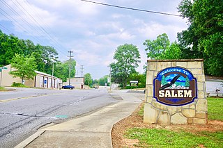
Salem is a U.S. town in Oconee County, South Carolina. The population was 135 at the 2010 United States Census.

<span class="mw-page-title-main">Walhalla, South Carolina</span> City in South Carolina, United States

Walhalla is a city in the foothills of the Blue Ridge Mountains in Oconee County, South Carolina. Designated in 1868 as the county seat, it lies within the area of the Blue Ridge Escarpment, an area of transition between mountains and piedmont, and contains numerous waterfalls. It is located 16 miles (26 km) from Clemson University in Clemson, South Carolina.

<span class="mw-page-title-main">Liberty, South Carolina</span> City in South Carolina, United States

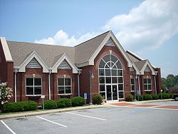
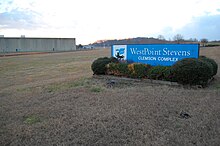
Liberty is a city in Pickens County, South Carolina, United States. It is part of the Greenville–Mauldin–Easley Metropolitan Statistical Area. The city was chartered on March 2, 1876.

<span class="mw-page-title-main">Pickens, South Carolina</span> City in South Carolina, United States

Pickens, formerly called Pickens Courthouse, is a city in and the county seat of Pickens County, South Carolina, United States. The population was 3,126 at the 2010 census. Pickens changed its classification from a town to a city in 1998, but it was not reported to the Census Bureau until 2001. It was named after Andrew Pickens (1739–1817), an American revolutionary soldier and US Congressman for South Carolina.

<span class="mw-page-title-main">Lake Jocassee</span> Man-made lake in northwestern South Carolina, United States

Lake Jocassee is a 7,500-acre (30 km2), 300-foot (91 m) deep reservoir in northwest South Carolina. It was created in 1973 by the state in partnership with Duke Power. The lake is known for the clean and cold Appalachian mountain rivers that flow into it, keeping its waters cool and clear year-round. The Jocassee Dam, which forms the lake, is 385 feet (117 m) high and 1,750 feet (530 m) long. The lake is within Devils Fork State Park.

The Little River originally flowed 27.0 miles (43.5 km) from its headwaters in northern Oconee County, South Carolina near Salem into the Keowee River northeast of Seneca.

<span class="mw-page-title-main">Lake Keowee</span> Man-made lake in South Carolina, United States

Lake Keowee is a man-made reservoir in the United States in the state of South Carolina. It was developed to serve the needs of power utility Duke Energy and public recreational purposes. It is approximately 26 miles (42 km) long, 3 miles (4.8 km) wide, with an average depth of 54 feet (16 m), and a shoreline measured at 300 miles (480 km) in total, and is approximately 800 feet (240 m) above sea level.

<span class="mw-page-title-main">Old Stone Church and Cemetery</span> Historic site in South Carolina, United States

Old Stone Church is a church building built in 1802. When it was constructed, it was in the Pendleton District, South Carolina. When Pendleton District was divided in 1826, the church was in Pickens District. When Pickens District was split in 1868, it was in Oconee County, South Carolina. In 1968, this section of Oconee County was annexed back to Pickens County. The church is about midway between the centers of Pendleton and Clemson. It is now in the city limits of Clemson.

<span class="mw-page-title-main">Oconee Nuclear Station</span> Power station in South Carolina

The Oconee Nuclear Station is a nuclear power station located on Lake Keowee near Seneca, South Carolina, and has a power output capacity of over 2,500 megawatts. It is the second nuclear power station in the United States to have its operating license extended for an additional twenty years by the Nuclear Regulatory Commission (NRC).

<span class="mw-page-title-main">Newry, South Carolina</span> Census-designated place in South Carolina, United States

Newry is a census-designated place in Oconee County, South Carolina. According to the 2020 United States Census, the population of the CDP was 199.

<span class="mw-page-title-main">South Carolina Highway 130</span> State highway in South Carolina, United States

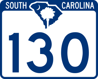
South Carolina Highway 130 (SC 130) is a 30.072-mile (48.396 km) state highway in Oconee County, South Carolina, connecting Clemson and eastern Oconee County with access to Lake Keowee, Lake Jocassee, and the Blue Ridge Mountains.

Keowee Key is a lakeside community and census-designated place (CDP) in Oconee County, South Carolina, United States. It is considered part of the Salem community. It was first listed as a CDP prior to the 2020 census with a population of 2,716.

References

  1. "ArcGIS REST Services Directory". United States Census Bureau. Retrieved October 15, 2022.
  2. 1 2 U.S. Geological Survey Geographic Names Information System: Seneca, South Carolina
  3. 1 2 "Census Population API". United States Census Bureau. Retrieved October 15, 2022.
  4. 1 2 "U.S. Census website". United States Census Bureau . Retrieved January 31, 2008.
  5. Louise Matheson Bell, Seneca: Visions of Yesterday, 2003, ISBN   0-9763843-0-2.
  6. Edgar, Walter, ed. The South Carolina Encyclopedia, University of South Carolina Press, 2006, p. 859, ISBN   1-57003-598-9.
  7. NWS Damage Survey for EF3 Tornado Event (Report). Iowa Environmental Mesonet. April 13, 2020. Retrieved April 13, 2020.{{cite report}}: Unknown parameter |agency= ignored (help)
  8. "National Register Information System". National Register of Historic Places . National Park Service. July 9, 2010.
  9. Pictures of the Seneca Historic District
  10. Seneca Historic District nomination form I
  11. Seneca Historic District nomination form II
  12. Map of Seneca Historic District
  13. Pictures of the Ram Cat Alley Historic District
  14. Ram Cat Alley Historic District nomination form
  15. Map of the Ram Cat Alley Historic District
  16. Pictures of the Newry Historic District
  17. Newry Historic District nomination form
  18. Map of the Newry Historic District
  19. "US Gazetteer files: 2010, 2000, and 1990". United States Census Bureau. February 12, 2011. Retrieved April 23, 2011.
  20. "U.S. Decennial Census". United States Census Bureau. Retrieved January 18, 2015.
  21. "Explore Census Data". data.census.gov. Retrieved December 14, 2021.
  22. "South Carolina libraries and archives". SCIWAY. Retrieved June 13, 2019.
  23. "United States Senator Lindsey Graham, South Carolina : Biography". Lgraham.senate.gov. Retrieved May 8, 2016.