Berkeley County, South Carolina

Last updated

Berkeley County
Old Berkeley County Courthouse - Mount Pleasant, SC.jpg
Berkeley County Seal.jpg
Berkeley County Logo.png
Motto(s): 
"One Berkeley"
"Rich History. Bright Future."
Map of South Carolina highlighting Berkeley County.svg
Location within the U.S. state of South Carolina
South Carolina in United States.svg
South Carolina's location within the U.S.
Coordinates: 33°13′N79°57′W / 33.21°N 79.95°W / 33.21; -79.95
CountryFlag of the United States.svg United States
StateFlag of South Carolina.svg  South Carolina
Founded1882
Named for Sir William Berkeley
Seat Moncks Corner
Largest community Goose Creek
Government
  County SupervisorJohnny Cribb
Area
  Total1,233.88 sq mi (3,195.7 km2)
  Land1,103.62 sq mi (2,858.4 km2)
  Water130.26 sq mi (337.4 km2)  10.56%
Population
 (2020)
  Total229,861
  Estimate 
(2023)
255,217
  Density208.28/sq mi (80.42/km2)
Time zone UTC−5 (Eastern)
  Summer (DST) UTC−4 (EDT)
Congressional district 1st
Website www.berkeleycountysc.gov

Berkeley County is a county in the U.S. state of South Carolina. As of the 2020 census, its population was 229,861. [1] Its county seat is Moncks Corner, and the largest community is Goose Creek. [2] After two previous incarnations of Berkeley County, the current county was created in 1882. [3] Berkeley County is included in the Charleston-North Charleston, SC Metropolitan Statistical Area.

Contents

History

Berkeley County was established in 1682. It was named after John and William Berkeley, co-owners of the Province of Carolina. [4] It became part of the Charleston District in 1769. It did not exist as a District during most of the 19th century and generally was part of the Low Country culture. In 1882, after Democrats regained control of the state legislature following the Reconstruction era, they established the current incarnation of Berkeley County, with its seat at Mount Pleasant. The county seat was moved in 1895 to Moncks Corner. [3]

The Old Berkeley County Courthouse was listed on the National Register of Historic Places in 1971. [5]

Geography

Berkeley County, South Carolina
Interactive map of Berkeley County

According to the U.S. Census Bureau, the county has a total area of 1,233.88 square miles (3,195.7 km2), of which 1,103.62 square miles (2,858.4 km2) is land and 130.26 square miles (337.4 km2) (10.56%) is water. [6]

National protected areas

State and local protected areas/sites

Major water bodies

Adjacent counties

Major highways

Major infrastructure

Demographics

Historical population
CensusPop.Note
1890 55,428
1900 30,454−45.1%
1910 23,487−22.9%
1920 22,558−4.0%
1930 22,236−1.4%
1940 27,12822.0%
1950 30,25111.5%
1960 38,19626.3%
1970 56,19947.1%
1980 94,72768.6%
1990 128,77635.9%
2000 142,65110.8%
2010 177,84324.7%
2020 229,86129.2%
2023 (est.)255,217 [1] 11.0%
U.S. Decennial Census [8]
1790–1960 [9] 1900–1990 [10]
1990–2000 [11] 2010 [12] 2020 [1]

2020 census

Berkeley County racial composition [13]
RaceNum.Perc.
White (non-Hispanic)137,84059.97%
Black or African American (non-Hispanic)51,78422.53%
Native American 1,0350.45%
Asian 5,3532.33%
Pacific Islander 1730.08%
Other/Mixed 13,3485.81%
Hispanic or Latino 20,3288.84%

As of the 2020 census, there were 229,861 people, 80,640 households, and 57,117 families residing in the county.

2010 census

At the 2010 census, there were 177,843 people, 65,419 households, and 47,141 families living in the county. [14] [12] The population density was 161.8 inhabitants per square mile (62.5/km2). There were 73,372 housing units at an average density of 66.8 per square mile (25.8/km2). [15] The racial makeup of the county was 66.5% white, 25.0% black or African American, 2.3% Asian, 0.6% American Indian, 0.1% Pacific islander, 2.8% from other races, and 2.7% from two or more races. Those of Hispanic or Latino origin made up 6.0% of the population. [14] [16]

Of the 65,419 households, 38.0% had children under the age of 18 living with them, 51.3% were married couples living together, 15.3% had a female householder with no husband present, 27.9% were non-families, and 22.0% of households were made up of individuals. The average household size was 2.66 and the average family size was 3.10. The median age was 34.5 years. [14]

The median household income was $50,777 and the median family income was $56,869. Males had a median income of $40,534 versus $30,997 for females. The per capita income for the county was $22,865. About 9.9% of families and 12.6% of the population were below the poverty line, including 18.2% of those under age 18 and 10.3% of those age 65 or over. [17]

2000 census

At the 2000 census, there were 142,651 people, 49,922 households, and 37,691 families living in the county. The population density was 130 people per square mile (50 people/km2). There were 54,717 housing units at an average density of 50 per square mile (19/km2). The racial makeup of the county was 68.00% White, 26.63% Black or African American, 0.52% Native American, 1.87% Asian, 0.08% Pacific Islander, 1.20% from other races, and 1.70% from two or more races. 2.76% of the population were Hispanic or Latino of any race. 16.4% were of American, 10.0% German, 8.4% Irish and 7.7% English ancestry according to Census 2000. [18] Of the 49,922 households 39.20% had children under the age of 18 living with them, 56.70% were married couples living together, 14.20% had a female householder with no husband present, and 24.50% were non-families. 19.40% of households were one person and 5.60% were one person aged 65 or older. The average household size was 2.75 and the average family size was 3.15.

The age distribution was 28.00% under the age of 18, 11.70% from 18 to 24, 31.20% from 25 to 44, 21.20% from 45 to 64, and 7.90% 65 or older. The median age was 32 years. For every 100 females, there were 103.20 males. For every 100 females age 18 and over, there were 102.20 males.

The median household income was $39,908 and the median family income was $44,242. Males had a median income of $31,583 versus $22,420 for females. The per capita income for the county was $16,879. About 9.70% of families and 11.80% of the population were below the poverty line, including 15.60% of those under age 18 and 12.90% of those age 65 or over.

Government and politics

County government (as of 2023): [19]

Berkeley County Council:

Other Eected Officials:

In 2020, Joe Biden received 43.3% of the vote, the best performance for a Democrat since Jimmy Carter in 1976.

United States presidential election results for Berkeley County, South Carolina [20]
Year Republican Democratic Third party
No.%No.%No.%
2020 57,39754.95%45,22343.29%1,8381.76%
2016 44,58756.07%30,70538.61%4,2255.31%
2012 38,47556.42%28,54241.85%1,1781.73%
2008 36,20555.89%27,75542.84%8211.27%
2004 32,10460.65%20,14238.05%6911.31%
2000 24,79657.24%17,70740.88%8131.88%
1996 17,69153.22%13,35840.18%2,1936.60%
1992 18,04850.87%12,53335.33%4,89813.81%
1988 16,77963.81%9,31235.41%2060.78%
1984 16,97269.24%7,38030.11%1590.65%
1980 12,83055.63%9,85042.71%3841.66%
1976 6,98141.60%9,74158.05%590.35%
1972 9,34566.66%4,49732.08%1771.26%
1968 4,02128.89%5,08936.56%4,80834.55%
1964 6,10063.30%3,53736.70%00.00%
1960 2,42248.79%2,54251.21%00.00%
1956 1,05528.24%90224.14%1,77947.62%
1952 2,48259.24%1,70840.76%00.00%
1948 583.02%32316.83%1,53880.15%
1944 324.47%52172.77%16322.77%
1940 9115.66%49084.34%00.00%
1936 81.15%69098.85%00.00%
1932 222.28%94197.72%00.00%
1928 4213.21%27686.79%00.00%
1924 264.93%50195.07%00.00%
1920 244.20%54895.80%00.00%
1916 61.30%45798.70%00.00%
1912 51.47%32394.72%133.81%
1908 23527.84%60972.16%00.00%
1904 11514.74%66585.26%00.00%
1900 11219.18%47280.82%00.00%
1896 18325.96%51372.77%91.28%
1892 1,17152.30%1,03746.32%311.38%

Economy

In 2022, the GDP of Berkeley County was $10.6 billion (approx. $46,147 per capita). [21] In chained 2017 dollars, its real GDP was $9 billion (about $39,335 per capita). [22] From 2022 through 2024, its unemployment rate has fluctuated around 3%. [23]

As of April 2024, some of the largest employers in the county include Blackbaud, Booz Allen Hamilton, Nucor, Publix, Volvo, and Walmart. [24]

Employment and Wage Statistics by Industry in Berkeley County, South Carolina [24]
IndustryEmployment CountsEmployment Percentage (%)Average Annual Wage ($)
Accommodation and Food Services6,30610.623,088
Administrative and Support and Waste Management and Remediation Services2,5074.241,756
Agriculture, Forestry, Fishing and Hunting960.262,504
Arts, Entertainment, and Recreation1,0311.728,808
Construction3,7576.372,072
Finance and Insurance1,5192.679,092
Health Care and Social Assistance4,2437.157,096
Information1,8863.2124,384
Management of Companies and Enterprises3760.695,680
Manufacturing9,40615.879,976
Mining, Quarrying, and Oil and Gas Extraction1320.278,156
Other Services (except Public Administration)2,2383.856,888
Professional, Scientific, and Technical Services5,9119.991,988
Public Administration2,9645.051,636
Real Estate and Rental and Leasing8891.575,556
Retail Trade8,27113.936,036
Transportation and Warehousing3,8816.559,956
Utilities1,5172.692,560
Wholesale Trade2,4874.270,824
Total59,417100.0%62,118

Education

All of the county is in the Berkeley County School District. [25]

Attractions

Communities

Cities

Towns

Census-designated places

Unincorporated communities

See also

Related Research Articles

<span class="mw-page-title-main">Williamsburg County, South Carolina</span> County in South Carolina, United States

Williamsburg County is a county located in the U.S. state of South Carolina. As of the 2020 census its population was 31,026. The county seat and largest community is Kingstree. After a previous incarnation of Williamsburg County, the current county was created in 1804.

<span class="mw-page-title-main">Saluda County, South Carolina</span> County in South Carolina, United States

Saluda County is a county in the U.S. state of South Carolina. As of the 2020 census, the population was 18,862. Its county seat is Saluda. The county was formed from northern and eastern portions of Edgefield County.

<span class="mw-page-title-main">Orangeburg County, South Carolina</span> County in South Carolina, United States

Orangeburg County is a county located in the U.S. state of South Carolina. As of the 2020 census, the population was 84,223. Its county seat is Orangeburg. The county was created in 1769.

<span class="mw-page-title-main">Lexington County, South Carolina</span> County in South Carolina, United States

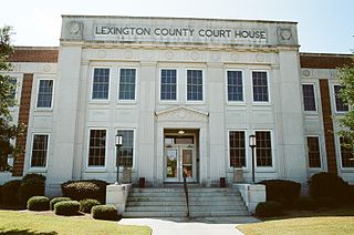
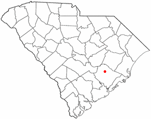
Lexington County is a county located in the U.S. state of South Carolina. As of the 2020 census, the population was 293,991. Its county seat and largest community is Lexington. The county was chartered in 1785 and was named in commemoration of Lexington, Massachusetts, the site of the Battle of Lexington in the American Revolutionary War. Lexington County is the sixth-most populous county in South Carolina by population and is part of the Columbia, SC Metropolitan Statistical Area. It is located in the Midlands region of South Carolina.

<span class="mw-page-title-main">Dorchester County, South Carolina</span> County in South Carolina, United States

Dorchester County is a county located in the U.S. state of South Carolina. As of the 2020 census, the population was 161,540. Its county seat is St. George.

<span class="mw-page-title-main">Colleton County, South Carolina</span> County in South Carolina, United States

Colleton County is in the Lowcountry region of the U.S. state of South Carolina. As of the 2020 census, the population was 38,604. Its county seat is Walterboro. The county is named after Sir John Colleton, 1st Baronet, one of the eight Lords Proprietor of the Province of Carolina. After two previous incarnations, the current Colleton County was created in 1800.

<span class="mw-page-title-main">Clarendon County, South Carolina</span> County in South Carolina, United States

Clarendon County is a county located below the fall line in the Coastal Plain region of U.S. state of South Carolina. As of the 2020 census, its population was 31,144. Its county seat is Manning.

<span class="mw-page-title-main">Charleston County, South Carolina</span> County in South Carolina, United States

Charleston County is located in the U.S. state of South Carolina along the Atlantic coast. As of the 2020 census, the population was 408,235, making it the third-most populous county in South Carolina. Its county seat is Charleston. It is also the largest county in the state by total area, although Horry County has a larger land area. The county was created in 1800 by an act of the South Carolina State Legislature.

<span class="mw-page-title-main">Aiken County, South Carolina</span> County in South Carolina, United States

Aiken County is a county in the U.S. state of South Carolina. As of the 2020 census, its population was 168,808. Its county seat and largest community is Aiken. Aiken County is a part of the Augusta-Richmond County, GA-SC Metropolitan Statistical Area. It is mostly in the Sandhills region, with the northern parts reaching in the Piedmont and southern parts reaching into the Coastal Plain.

<span class="mw-page-title-main">Bonneau, South Carolina</span> Town in South Carolina, United States

Bonneau is a town in Berkeley County, South Carolina, United States. The population was 487 at the 2010 census. It is part of the Charleston–North Charleston–Summerville Metropolitan Statistical Area.

<span class="mw-page-title-main">Jamestown, South Carolina</span> Town in South Carolina, United States

Jamestown is a town in Berkeley County, South Carolina, United States. The population was 72 at the 2010 census.

<span class="mw-page-title-main">Moncks Corner, South Carolina</span> Town in South Carolina, United States

Moncks Corner is a town in and the county seat of Berkeley County, South Carolina, United States. The population was 7,885 at the 2010 census. As defined by the U.S. Census Bureau, Moncks Corner is included within the Charleston-North Charleston, SC Metropolitan Statistical Area.

<span class="mw-page-title-main">St. Stephen, South Carolina</span> Town in South Carolina, United States

St. Stephen is a town in Berkeley County, South Carolina, United States. The population was 1,697 at the 2010 census.

<span class="mw-page-title-main">Rockville, South Carolina</span> Town in South Carolina, United States

Rockville is a town in Charleston County, South Carolina, United States, that was founded in 1784. The population was 134 at the 2010 census. Rockville is part of the Charleston-North Charleston-Summerville metropolitan area.

<span class="mw-page-title-main">Ridgeville, South Carolina</span> Town in South Carolina, United States

Ridgeville is a town in Dorchester County, South Carolina, United States. The population was 1,979 at the 2010 census, up from 1,690 at the 2000 census. Ridgeville is part of the Charleston-North Charleston-Summerville metropolitan area.

<span class="mw-page-title-main">St. George, South Carolina</span> Town in South Carolina, United States

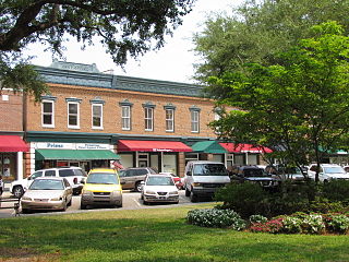
Saint George is a town in Dorchester County, South Carolina, United States. The population was 2,084 at the 2010 census, eight fewer than in 2000 census. It has been the county seat of Dorchester County since the county was formed from Colleton County in 1897.

<span class="mw-page-title-main">Eutawville, South Carolina</span> Town in South Carolina, United States

Eutawville is a town in Orangeburg County, South Carolina, United States. Prior to 1910, Eutawville was located in the northwest portion of Saint James Goose Creek Township, Berkeley County. The population was 315 at the 2010 census.

Stateburg is a census-designated place (CDP) in the High Hills of Santee in Sumter County, South Carolina, United States. The population was 1,380 at the 2010 census. It is included in the Sumter, South Carolina Metropolitan Statistical Area. Stateburg is located within the larger Stateburg Historic District.

<span class="mw-page-title-main">Ladson, South Carolina</span> Census-designated place in South Carolina, United States

Ladson is a census-designated place (CDP) in Berkeley, Charleston and Dorchester counties in the U.S. state of South Carolina. The population was 13,790 at the 2010 census. It is named in honor of the Ladson family, one of the oldest planter and merchant families in the Charleston area; one of its members was lieutenant governor James Ladson.

<span class="mw-page-title-main">Summerville, South Carolina</span> Town in South Carolina, United States

Summerville is a town in the U.S. state of South Carolina situated mostly in Dorchester County, with small portions in Berkeley and Charleston counties. It is part of the Charleston-North Charleston-Summerville, SC Metropolitan Statistical Area. Summerville's population at the 2020 census was 50,915.

References

  1. 1 2 3 "QuickFacts: Berkeley County, South Carolina". United States Census Bureau. Retrieved March 22, 2024.
  2. "Find a County". National Association of Counties. Archived from the original on May 31, 2011. Retrieved June 7, 2011.
  3. 1 2 "South Carolina: Individual County Chronologies". South Carolina Atlas of Historical County Boundaries. The Newberry Library. 2009. Archived from the original on January 3, 2017. Retrieved March 20, 2015.
  4. Federal Writers' Project (1941). Palmetto Place Names. Sloane Printing Co. p. 12.
  5. "National Register Information System". National Register of Historic Places . National Park Service. July 9, 2010.
  6. "2020 County Gazetteer Files – South Carolina". United States Census Bureau. August 23, 2022. Retrieved September 10, 2023.
  7. 1 2 3 4 5 "SCDNR Public Lands". www2.dnr.sc.gov. Retrieved April 1, 2023.
  8. "U.S. Decennial Census". United States Census Bureau. Retrieved March 16, 2015.
  9. "Historical Census Browser". University of Virginia Library. Retrieved March 16, 2015.
  10. Forstall, Richard L., ed. (March 27, 1995). "Population of Counties by Decennial Census: 1900 to 1990". United States Census Bureau. Retrieved March 16, 2015.
  11. "Census 2000 PHC-T-4. Ranking Tables for Counties: 1990 and 2000" (PDF). United States Census Bureau. April 2, 2001. Archived (PDF) from the original on October 9, 2022. Retrieved March 16, 2015.
  12. 1 2 "State & County QuickFacts". United States Census Bureau. Archived from the original on June 6, 2011. Retrieved November 22, 2013.
  13. "Explore Census Data". data.census.gov. Retrieved December 15, 2021.
  14. 1 2 3 "DP-1 Profile of General Population and Housing Characteristics: 2010 Demographic Profile Data". United States Census Bureau. Archived from the original on February 13, 2020. Retrieved March 9, 2016.
  15. "Population, Housing Units, Area, and Density: 2010 - County". United States Census Bureau. Archived from the original on February 13, 2020. Retrieved March 9, 2016.
  16. "DP02 SELECTED SOCIAL CHARACTERISTICS IN THE UNITED STATES – 2006-2010 American Community Survey 5-Year Estimates". United States Census Bureau. Archived from the original on February 13, 2020. Retrieved March 9, 2016.
  17. "DP03 SELECTED ECONOMIC CHARACTERISTICS – 2006-2010 American Community Survey 5-Year Estimates". United States Census Bureau. Archived from the original on February 13, 2020. Retrieved March 9, 2016.
  18. "U.S. Census website". United States Census Bureau . Retrieved May 14, 2011.
  19. "County Officials". www.berkeleycountysc.gov. Retrieved March 7, 2024.
  20. Leip, David. "Dave Leip's Atlas of U.S. Presidential Elections". uselectionatlas.org. Retrieved March 13, 2018.
  21. U.S. Bureau of Economic Analysis (January 1, 2001). "Gross Domestic Product: All Industries in Berkeley County, SC". FRED, Federal Reserve Bank of St. Louis. Retrieved April 30, 2024.
  22. U.S. Bureau of Economic Analysis (January 1, 2001). "Real Gross Domestic Product: All Industries in Berkeley County, SC". FRED, Federal Reserve Bank of St. Louis. Retrieved April 30, 2024.
  23. U.S. Bureau of Labor Statistics (January 1, 1990). "Unemployment Rate in Berkeley County, SC". FRED, Federal Reserve Bank of St. Louis. Retrieved April 30, 2024.
  24. 1 2 "Berkeley County" (PDF). Community Profiles (04000015). Columbia, South Carolina: S.C. Department of Employment & Workforce - Business Intelligence Department. April 19, 2024.
  25. "2020 CENSUS - SCHOOL DISTRICT REFERENCE MAP: Berkeley County, SC" (PDF). U.S. Census Bureau. Archived (PDF) from the original on October 9, 2022. Retrieved August 1, 2022. - Text list