Orangeburg County, South Carolina

Last updated

Orangeburg County
Old Orangeburg Co SC jail from SW 1.JPG
Orangeburg County Flag.png
Orangeburg County Seal.png
Motto: 
"Community & Character"
Map of South Carolina highlighting Orangeburg County.svg
Location within the U.S. state of South Carolina
South Carolina in United States.svg
South Carolina's location within the U.S.
Coordinates: 33°26′N80°48′W / 33.44°N 80.80°W / 33.44; -80.80
CountryFlag of the United States.svg United States
StateFlag of South Carolina.svg  South Carolina
FoundedMarch 12, 1785
Named for William of Orange
Seat Orangeburg
Largest communityOrangeburg
Area
  Total1,127.89 sq mi (2,921.2 km2)
  Land1,106.38 sq mi (2,865.5 km2)
  Water21.51 sq mi (55.7 km2)  1.91%
Population
 (2020)
  Total84,223
  Estimate 
(2023)
82,820
  Density76.12/sq mi (29.39/km2)
Time zone UTC−5 (Eastern)
  Summer (DST) UTC−4 (EDT)
Congressional districts 2nd, 6th
Website www.orangeburgcounty.org

Orangeburg County is a county located in the U.S. state of South Carolina. As of the 2020 census, the population was 84,223. [1] Its county seat is Orangeburg. [2] The county was created in 1769. [3]

Contents

Orangeburg County comprises the Orangeburg, SC Micropolitan Statistical Area, which is also included in the Columbia-Sumter-Orangeburg, SC Combined Statistical Area. It is located in the Midlands region of South Carolina.

It is the home of South Carolina State University, the only public four-year HBCU in the state of South Carolina. It is also home to Claflin University, the oldest historically black college or university (HBCU) in the state.

History

The district was occupied for thousands of years by succeeding cultures of indigenous peoples. By the time of European encounter, Siouan-speaking tribes, such as the Cheraw and Catawba, as well as the Pee Dee, inhabited the Piedmont area above the fall line.

The Orangeburg Judicial District was chartered by European Americans in 1769 from a mostly unorganized upland area between the Congaree and Savannah rivers. A county, initially of the same name but later called Orange, was organized within the district but deorganized in 1791, after the American Revolutionary War.

The southwest portion bordering on the Savannah River, about half of Orangeburg District, was separated and organized as Barnwell District in 1800. In 1804 the northern third of the district was separated to form the new Lexington District, which gained another, smaller portion of Orangeburg District in 1832.

During the nineteenth century, the districts and counties were developed chiefly as cotton plantations for short-staple cotton. This development followed the invention of the cotton gin in the late eighteenth century, which made the processing of short-staple cotton profitable. The county became a center of labor by black slaves on the plantations, who were transported from coastal areas and the Upper South to cultivate and process cotton. Those brought from the coastal areas were likely of the Gullah culture and language. The enslaved African Americans greatly outnumbered the white planters and non-slaveholding whites. Reflecting the patterns of nineteenth-century settlement, the area is still chiefly agricultural and majority-African American in population.

In 1868, under the revised state constitution during the Reconstruction era, South Carolina districts were organized as counties. Resident voters were enabled to elect their state representatives rather than having them chosen by the state legislature, as was done previously. Election of representatives by the state legislature had kept the districts dominated by the elite owners of major plantations in the Low Country and elsewhere. The changes in rules expanded participation in the franchise by more male residents. Emancipation of slaves after the war under newly ratified federal constitutional amendments resulted in freedmen voting. Using voter intimidation, white Democrats took control of the state legislature by the end of the century; they passed state electoral laws and a new constitution that essentially disfranchised most blacks, a situation that lasted until after the federal legislation of the 1965 Voting Rights Act.

A small western portion of Orangeburg County was annexed in 1871 to the newly formed Aiken County during the Reconstruction era.

In 1908 the northern portion of the County along the Congaree River was separated and included in the newly formed Calhoun County, with its seat at Saint Matthews. In 1910 a small western portion of Berkeley County, around Holly Hill and Eutawville, was annexed to Orangeburg County, thus bringing the county to its present size.

Geography

Orangeburg County, South Carolina
Interactive map of Orangeburg County
First Baptist Church, downtown Orangeburg First Baptist Church Orangeburg.jpg
First Baptist Church, downtown Orangeburg

According to the U.S. Census Bureau, the county has a total area of 1,127.89 square miles (2,921.2 km2), of which 1,106.38 square miles (2,865.5 km2) is land and 21.51 square miles (55.7 km2) (1.91%) is water. [4] It is the second-largest county in South Carolina by land area and fifth-largest by land area.

Orangeburg county is a fairly big county, covering 1,128 square miles, it is about 60 miles from the western part of the county to the eastern part of the county. Orangeburg county lies within 3 "regions" of South Carolina. The western part of the county lies in the "CSRA" (Central Savannah River Area). The middle part of Orangeburg county is included in the "Midlands" Region. The eastern and south eastern part of the county are located in the "Lowcountry" region of the state.

National protected areas

State and local protected areas

Major water bodies

Adjacent counties

Demographics

Historical population
CensusPop.Note
1790 18,513
1800 15,766−14.8%
1810 13,229−16.1%
1820 15,65318.3%
1830 18,45317.9%
1840 18,5190.4%
1850 23,58227.3%
1860 24,8965.6%
1870 16,865−32.3%
1880 41,395145.4%
1890 49,39319.3%
1900 59,66320.8%
1910 55,893−6.3%
1920 64,90716.1%
1930 63,864−1.6%
1940 63,707−0.2%
1950 68,7267.9%
1960 68,559−0.2%
1970 69,7891.8%
1980 82,27617.9%
1990 84,8033.1%
2000 91,5828.0%
2010 92,5011.0%
2020 84,223−8.9%
2023 (est.)82,820 [1] −1.7%
U.S. Decennial Census [6]
1790–1960 [7] 1900–1990 [8]
1990–2000 [9] 2010 [10] 2020 [1]

2020 census

Orangeburg County racial composition [11]
RaceNum.Perc.
White (non-Hispanic)27,78732.99%
Black or African American (non-Hispanic)50,80260.32%
Native American 4670.55%
Asian 8921.06%
Pacific Islander 370.04%
Other/Mixed 2,2712.7%
Hispanic or Latino 1,9672.34%

As of the 2020 census, there were 84,223 people, 32,129 households, and 20,620 families residing in the county.

2010 census

At the 2010 census, there were 92,501 people, 35,788 households, and 23,580 families in the county. [12] [10] The population density was 83.6 inhabitants per square mile (32.3 inhabitants/km2). There were 42,504 housing units at an average density of 38.4 units per square mile (14.8 units/km2). [13] The racial makeup of the county was 62.2% black or African American, 34.3% white, 0.8% Asian, 0.5% American Indian, 0.9% from other races, and 1.2% from two or more races. Those of Hispanic or Latino origin made up 1.9% of the population. [12] In terms of ancestry, 7.7% were American, and 5.1% were German. [14]

Of the 35,788 households, 32.5% had children under the age of 18 living with them, 38.1% were married couples living together, 22.5% had a female householder with no husband present, 34.1% were non-families, and 29.0% of households were made up of individuals. The average household size was 2.49 and the average family size was 3.06. The median age was 38.1 years. [12]

The median household income was $32,849 and the median family income was $40,332. Males had a median income of $35,934 versus $28,508 for females. The per capita income for the county was $17,579. About 21.1% of families and 25.8% of the population were below the poverty line, including 32.9% of those under age 18 and 19.1% of those age 65 or over. [15]

2000 census

At the 2000 census, there were 91,582 people, 34,118 households, and 23,882 families in the county. The population density was 83 people per square mile (32 people/km2). There were 39,304 housing units at an average density of 36 units per square mile (14 units/km2). The racial makeup of the county was 60.86% Black or African American, 37.17% White, 0.46% Native American, 0.43% Asian, 0.02% Pacific Islander, 0.36% from other races, and 0.70% from two or more races. 0.96% of the population were Hispanic or Latino of any race. [16] Of the 34,118 households 32.00% had children under the age of 18 living with them, 45.10% were married couples living together, 20.30% had a female householder with no husband present, and 30.00% were non-families. 26.00% of households were one person and 10.30% were one person aged 65 or older. The average household size was 2.58 and the average family size was 3.11.

The age distribution was 26.00% under the age of 18, 11.90% from 18 to 24, 26.10% from 25 to 44, 22.80% from 45 to 64, and 13.20% 65 or older. The median age was 35 years. For every 100 females there were 87.00 males. For every 100 females age 18 and over, there were 81.60 males.

The median household income was $29,567 and the median family income was $36,165. Males had a median income of $29,331 versus $20,956 for females. The per capita income for the county was $15,057. About 17.00% of families and 21.40% of the population were below the poverty line, including 27.20% of those under age 18 and 22.30% of those age 65 or over.

Native American entities

Orangeburg County is home to four state-recognized Native American entities.

State-recognized tribes

State-recognized group

State-recognized special interest organization

Government and politics

Orangeburg is a solidly Democratic county in presidential elections; it has not voted Republican since 1972.

United States presidential election results for Orangeburg County, South Carolina [22]
Year Republican Democratic Third party
No.%No.%No.%
2020 13,60333.01%27,29566.24%3070.75%
2016 11,93130.66%26,31867.64%6611.70%
2012 12,02227.93%30,72071.37%2990.69%
2008 12,11530.47%27,26368.58%3760.95%
2004 12,69533.80%24,69865.75%1710.46%
2000 12,65738.67%19,80260.49%2750.84%
1996 10,49434.62%18,61061.39%1,2113.99%
1992 11,32835.14%18,44057.21%2,4667.65%
1988 13,28147.35%14,65552.25%1130.40%
1984 14,28648.20%15,12151.02%2290.77%
1980 11,31340.79%16,17858.33%2420.87%
1976 8,79438.90%13,65260.40%1580.70%
1972 11,71159.31%7,65238.75%3821.93%
1968 5,14424.20%8,97142.20%7,14433.60%
1964 10,45665.09%5,60734.91%00.00%
1960 5,23357.36%3,89042.64%00.00%
1956 1,46721.20%2,51136.28%2,94342.52%
1952 4,69562.40%2,82937.60%00.00%
1948 1644.36%43511.56%3,16484.08%
1944 873.23%2,44090.61%1666.16%
1940 562.32%2,35697.68%00.00%
1936 591.96%2,94798.04%00.00%
1932 1114.03%2,64395.87%30.11%
1928 925.62%1,54594.38%00.00%
1924 673.71%1,72795.57%130.72%
1920 30410.74%2,52689.23%10.04%
1916 1595.62%2,64193.29%311.10%
1912 402.37%1,55091.99%955.64%
1908 40513.09%2,68786.87%10.03%
1904 2387.49%2,94192.51%00.00%
1900 1676.36%2,45793.64%00.00%

Economy

Orangeburg County is one of the largest agricultural producing counties in South Carolina, with fertile, slightly rolling land. Major crops are cotton, soybeans, corn, turf grass and watermelons.

In 2022, the GDP was $3.4 billion (about $40,510 per capita), [23] and the real GDP was $2.8 billion (about $33,219 per capita) in chained 2017 dollars. [24]

As of April 2024, some of the largest employers in the county include Claflin University, GPM Investments, Husqvarna Group, Love's, Medical University of South Carolina, Orangeburg–Calhoun Technical College, South Carolina State University, Okonite, and Walmart. [25]

Employment and Wage Statistics by Industry in Orangeburg County, South Carolina - Q3 2023 [25]
IndustryEmployment CountsEmployment Percentage (%)Average Annual Wage ($)
Accommodation and Food Services3,14611.219,968
Administrative and Support and Waste Management and Remediation Services8603.129,224
Agriculture, Forestry, Fishing and Hunting4791.746,072
Arts, Entertainment, and Recreation3081.119,292
Construction7402.664,272
Educational Services3,22811.548,464
Finance and Insurance4601.655,068
Health Care and Social Assistance3,97314.235,516
Information1190.461,880
Manufacturing4,83917.363,960
Other Services (except Public Administration)4461.637,336
Professional, Scientific, and Technical Services5081.853,768
Public Administration1,5205.449,712
Real Estate and Rental and Leasing1760.643,524
Retail Trade4,07414.629,796
Transportation and Warehousing1,9106.856,472
Utilities3211.172,436
Wholesale Trade8903.249,920
Total27,997100.0%43,840

Transportation

Major highways

Railroads

At least four railroad lines run through Orangeburg County; a former Southern Railway Line, and three CSX lines, the westernmost which was formerly a Seaboard Air Line Railroad line running along US 321. [26]

Major infrastructure

Communities

City

Towns

Census-designated places

See also

Related Research Articles

<span class="mw-page-title-main">Newberry County, South Carolina</span> County in South Carolina, United States

Newberry County is a county located in the U.S. state of South Carolina. As of the 2020 census, its population was 37,719. Its county seat is Newberry. The name is of unknown origin, although one theory suggests that it was named by Quaker settlers in honor of their home of Newberry, a suburb of London in the United Kingdom.

<span class="mw-page-title-main">Marlboro County, South Carolina</span> County in South Carolina, United States

Marlboro County is a county located in the Pee Dee region on the northern border of the U.S. state of South Carolina. As of the 2020 census, its population was 26,667. Its county seat is Bennettsville. The Great Pee Dee River runs through it.

<span class="mw-page-title-main">Georgetown County, South Carolina</span> County in South Carolina, United States

Georgetown County is a county located in the U.S. state of South Carolina. As of the 2020 census, the population was 63,404. Its county seat is Georgetown. The county was founded in 1769. It is named for George III of the United Kingdom.

<span class="mw-page-title-main">Dorchester County, South Carolina</span> County in South Carolina, United States

Dorchester County is a county located in the U.S. state of South Carolina. As of the 2020 census, the population was 161,540. Its county seat is St. George.

<span class="mw-page-title-main">Colleton County, South Carolina</span> County in South Carolina, United States

Colleton County is in the Lowcountry region of the U.S. state of South Carolina. As of the 2020 census, the population was 38,604. Its county seat is Walterboro. The county is named after Sir John Colleton, 1st Baronet, one of the eight Lords Proprietor of the Province of Carolina. After two previous incarnations, the current Colleton County was created in 1800.

<span class="mw-page-title-main">Clarendon County, South Carolina</span> County in South Carolina, United States

Clarendon County is a county located below the fall line in the Coastal Plain region of U.S. state of South Carolina. As of the 2020 census, its population was 31,144. Its county seat is Manning.

<span class="mw-page-title-main">Calhoun County, South Carolina</span> County in South Carolina, United States

Calhoun County is a county in the U.S. state of South Carolina. As of the 2020 census, its population was 14,119, making it the third-least populous county in the state. Its county seat is St. Matthews. In terms of land area, it is also the smallest county in the state.

<span class="mw-page-title-main">Berkeley County, South Carolina</span> County in South Carolina, United States

Berkeley County is a county in the U.S. state of South Carolina. As of the 2020 census, its population was 229,861. Its county seat is Moncks Corner, and the largest community is Goose Creek. After two previous incarnations of Berkeley County, the current county was created in 1882. Berkeley County is included in the Charleston-North Charleston, SC Metropolitan Statistical Area.

<span class="mw-page-title-main">Barnwell County, South Carolina</span> County in South Carolina, United States

Barnwell County is a county in the U.S. state of South Carolina. As of the 2020 census, its population was 20,589. It is located in the Central Savannah River Area. Its county seat is Barnwell.

<span class="mw-page-title-main">Bamberg County, South Carolina</span> County in South Carolina, United States

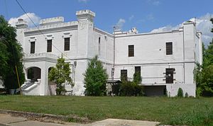
Bamberg County is a county located in the southwestern portion of U.S. state of South Carolina. As of the 2020 census, the population was 13,311, making the rural county the fourth-least populous of any in South Carolina. Its county seat is Bamberg.

<span class="mw-page-title-main">Aiken County, South Carolina</span> County in South Carolina, United States

Aiken County is a county in the U.S. state of South Carolina. As of the 2020 census, its population was 168,808. Its county seat and largest community is Aiken. Aiken County is a part of the Augusta-Richmond County, GA-SC Metropolitan Statistical Area. It is mostly in the Sandhills region, with the northern parts reaching in the Piedmont and southern parts reaching into the Coastal Plain.

<span class="mw-page-title-main">Abbeville County, South Carolina</span> County in South Carolina, United States

Abbeville County is a county located in the U.S. state of South Carolina. As of the 2020 census, its population was 24,295. Its county seat is Abbeville. It is the first county in the United States alphabetically. Abbeville County included in the Greenville-Spartanburg-Anderson, SC Combined Statistical Area, known colloquially as the Upstate or the Upcountry.

<span class="mw-page-title-main">Moncks Corner, South Carolina</span> Town in South Carolina, United States

Moncks Corner is a town in and the county seat of Berkeley County, South Carolina, United States. The population was 7,885 at the 2010 census. As defined by the U.S. Census Bureau, Moncks Corner is included within the Charleston-North Charleston, SC Metropolitan Statistical Area.

<span class="mw-page-title-main">Seabrook Island, South Carolina</span> Town in South Carolina, United States

Seabrook Island, formerly known as Simmons Island, is a barrier island in Charleston County, South Carolina, United States. The population was 1,714 at the 2010 census, up from 1,250 in 2000.

<span class="mw-page-title-main">Edisto Beach, South Carolina</span> Town in South Carolina, United States

Edisto Beach is a town in Colleton County, South Carolina, United States. Edisto Beach's population was 414 as of the 2010 census, down from 641 in 2000. The town limits include only the developed coastal area of Edisto Island within Colleton County, while the majority of the island consists of unincorporated land in Charleston County. Due to its status as a bedroom community, Edisto Beach is among the most affluent communities in the state.

<span class="mw-page-title-main">Edisto Island</span> Unincorporated area in South Carolina, United States

Edisto Island is one of South Carolina's Sea Islands, the larger part of which lies in Charleston County, with its southern tip in Colleton County. Edisto Beach is in Colleton County, and the Charleston County part of the island is unincorporated.

<span class="mw-page-title-main">Orangeburg, South Carolina</span> City in South Carolina, United States

Orangeburg, also known as The Garden City, is the principal city in and the county seat of Orangeburg County, South Carolina, United States. The population of the city was 13,964 according to the 2020 census. The city is located 37 miles southeast of Columbia, on the north fork of the Edisto River.

<span class="mw-page-title-main">Santee, South Carolina</span> Town in South Carolina, United States

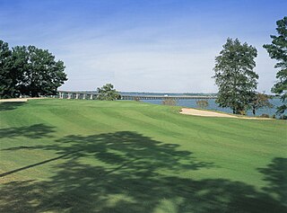
Santee is a town in Orangeburg County along the Santee River Valley in central South Carolina, United States. It has become a resort town of note located centrally north-south along the Atlantic Seaboard of South Carolina. The region has been rural, with a primarily agricultural economy typical of Orangeburg County, but is now known primarily for its several golf courses in proximity to Lake Marion, Santee State Park and other Lake Marion attractions. Interstate 95 connects its attractions easily with tourists traveling by automobile. I-95 crosses a narrow arm of the lake into the town lands, along a causeway. Lake Marion is a man-made hydroelectric reservoir, which at 110,000 acres is one of the fifty largest lakes in the country.

Stateburg is a census-designated place (CDP) in the High Hills of Santee in Sumter County, South Carolina, United States. The population was 1,380 at the 2010 census. It is included in the Sumter, South Carolina Metropolitan Statistical Area. Stateburg is located within the larger Stateburg Historic District.

<span class="mw-page-title-main">Santee Indian Organization</span> State-recognized tribe in South Carolina, United States

The Santee Indian Organization or Santee Indian Tribe is a state-recognized tribe and nonprofit organization headquartered in Holly Hill, South Carolina. The state of South Carolina awarded the organization the state-recognized tribe designation under the SC Code Section 1-31-40 (A) (7)(10), Statutory Authority Chapter 139 (100–110) on January 27, 2006. Since having obtained state-recognition the tribe remains federally unrecognized by the Bureau of Indian Affairs.

References

  1. 1 2 3 "QuickFacts: Orangeburg County, South Carolina". United States Census Bureau. Retrieved March 22, 2024.
  2. "Find a County". National Association of Counties. Archived from the original on May 3, 2015. Retrieved June 7, 2011.
  3. "South Carolina: Individual County Chronologies". South Carolina Atlas of Historical County Boundaries. The Newberry Library. 2009. Archived from the original on January 3, 2017. Retrieved March 21, 2015.
  4. "2020 County Gazetteer Files – South Carolina". United States Census Bureau. August 23, 2022. Retrieved September 10, 2023.
  5. "SCDNR Public Lands". www2.dnr.sc.gov. Retrieved April 1, 2023.
  6. "U.S. Decennial Census". United States Census Bureau. Retrieved March 18, 2015.
  7. "Historical Census Browser". University of Virginia Library. Retrieved March 18, 2015.
  8. Forstall, Richard L., ed. (March 27, 1995). "Population of Counties by Decennial Census: 1900 to 1990". United States Census Bureau. Retrieved March 18, 2015.
  9. "Census 2000 PHC-T-4. Ranking Tables for Counties: 1990 and 2000" (PDF). United States Census Bureau. April 2, 2001. Retrieved March 18, 2015.
  10. 1 2 "State & County QuickFacts". United States Census Bureau. Archived from the original on June 6, 2011. Retrieved November 25, 2013.
  11. "Explore Census Data". data.census.gov. Retrieved December 14, 2021.
  12. 1 2 3 "DP-1 Profile of General Population and Housing Characteristics: 2010 Demographic Profile Data". United States Census Bureau. Archived from the original on February 13, 2020. Retrieved March 11, 2016.
  13. "Population, Housing Units, Area, and Density: 2010 - County". United States Census Bureau. Archived from the original on February 13, 2020. Retrieved March 11, 2016.
  14. "DP02 SELECTED SOCIAL CHARACTERISTICS IN THE UNITED STATES – 2006-2010 American Community Survey 5-Year Estimates". United States Census Bureau. Archived from the original on February 13, 2020. Retrieved March 11, 2016.
  15. "DP03 SELECTED ECONOMIC CHARACTERISTICS – 2006-2010 American Community Survey 5-Year Estimates". United States Census Bureau. Archived from the original on February 13, 2020. Retrieved March 11, 2016.
  16. "U.S. Census website". United States Census Bureau . Retrieved May 14, 2011.
  17. Holleman, Joey (January 28, 2006). "Three S.C. Indian tribes win recognition". The State (Columbia, South Carolina). No. 115, No. 38. Newspapers.com. Retrieved December 28, 2023.
  18. 1 2 "South Carolina's Recognized Native American Indian Entities | Commission for Minority Affairs". cma.sc.gov. Retrieved December 28, 2023.
  19. "2005-2006 Bill 4797: Santee Indian Organization". scstatehouse.gov. Retrieved December 28, 2023.
  20. "Indian Entities Recognized by and Eligible To Receive Services From the United States Bureau of Indian Affairs". Indian Affairs Bureau. Federal Register. January 6, 2023. pp. 7554–58. Retrieved December 28, 2023.
  21. "Tax Exempt Organization Search". www.irs.gov. Retrieved January 12, 2024.
  22. Leip, David. "Dave Leip's Atlas of U.S. Presidential Elections". uselectionatlas.org. Retrieved March 13, 2018.
  23. U.S. Bureau of Economic Analysis (January 1, 2001). "Gross Domestic Product: All Industries in Orangeburg County, SC". FRED, Federal Reserve Bank of St. Louis. Retrieved May 4, 2024.
  24. U.S. Bureau of Economic Analysis (January 1, 2001). "Real Gross Domestic Product: All Industries in Orangeburg County, SC". FRED, Federal Reserve Bank of St. Louis. Retrieved May 4, 2024.
  25. 1 2 "Orangeburg County" (PDF). Community Profiles (04000075). Columbia, SC: S.C. Department of Employment & Workforce - Business Intelligence Department. April 19, 2024.
  26. "South Carolina - Railroads". www.carolana.com. Retrieved October 15, 2023.