North Augusta, South Carolina

Last updated

North Augusta, South Carolina
North Augusta 2008.jpg
Downtown North Augusta
North Augusta, SC City Flag.gif
North Augusta, SC City Seal.jpg
Nickname: 
South Carolina's Riverfront
SCMap-doton-NorthAugusta.PNG
Coordinates: 33°30′47″N81°57′46″W / 33.51306°N 81.96278°W / 33.51306; -81.96278
CountryFlag of the United States (23px).png  United States
State Flag of South Carolina.svg  South Carolina
Counties Aiken, Edgefield
Government
  MayorBriton Williams
Area
[1]
  Total21.84 sq mi (56.57 km2)
  Land21.29 sq mi (55.14 km2)
  Water0.55 sq mi (1.43 km2)
Elevation
387 ft (118 m)
Population
 (2020) [2]
  Total24,379
  Density1,145.04/sq mi (442.11/km2)
Time zone UTC−5 (Eastern (EST))
  Summer (DST) UTC−4 (EDT)
ZIP codes
29800-29899
Area code(s) 803, 839
FIPS code 45-50695 [3]
GNIS feature ID1231597 [4]
Website www.northaugustasc.gov

North Augusta is a city in Aiken and Edgefield counties in the U.S. state of South Carolina, on the north bank of the Savannah River. It lies directly across the river, and state border, from Augusta, Georgia. The population was 24,379 at the 2020 census, making it the 21st-most populous city in South Carolina. [5] The city is included in the Central Savannah River Area (CSRA) and is part of the Augusta, Georgia, metropolitan area.

Contents

History

North Augusta as seen from the south bank of Savannah River Cong Ao Gu Si Ta Kan De Sa Fan Na He .jpg
North Augusta as seen from the south bank of Savannah River

The city was incorporated in 1906 and sprouted from the pre-Civil War city of Hamburg. The original land area was approximately 772 acres. James U. Jackson was the city's primary visionary. He traveled to New York several times to receive financial support for the town and built the Thirteenth Street/ Georgia Avenue Bridge (James U. Jackson Memorial Bridge). [6]

In the early 20th century North Augusta was a popular vacation spot for northerners. Its popularity stemmed from its railroad connections and climate. In the Mid 20th century after the atomic bomb and during the Cold War, the city's population nearly quadrupled because the Savannah River Plant was constructed south of town. During this period the area of North Augusta increased from 772 acres to 5,139 acres. [6]

The Georgia Avenue-Butler Avenue Historic District, Charles Hammond House, Lookaway Hall, Britton Mims Place, Rosemary Hall and B.C. Wall House are listed on the National Register of Historic Places. [7]

North Augusta is also notable for nearby Murphy Village, a community of about 2,500 Irish Travelers that was featured on a 2012 episode of the TLC show, My Big Fat American Gypsy Wedding . [8] [9]

SRP Park

SRP Park is located in North Augusta along the Savannah River. SRP Park is the home of the Augusta GreenJackets, the Single-A affiliate of the Atlanta Braves.

Riverview Park Activities Center

The Riverview Park Activities Center is the host site for Nike's annual premier summer events, the Nike Peach Jam (boys) [10] and the Nike Nationals (girls). [11] The nation's top high school basketball prospects and college coaches gather in North Augusta each year for the tournaments.

Geography

North Augusta is located in western Aiken County at 33°30′47″N81°57′46″W / 33.51306°N 81.96278°W / 33.51306; -81.96278 (33.512935, -81.962640). [12] A small part of the city extends north into Edgefield County.

According to the United States Census Bureau, the city has a total area of 20.5 square miles (53.1 km2), of which 20.0 square miles (51.9 km2) is land and 0.46 square miles (1.2 km2), or 2.25%, is water. [13]

Highways

Education

North Augusta public schools includes two high schools, North Augusta High School and Fox Creek High School. North Augusta High School is in Aiken County and operates under the Aiken County School District. Fox Creek is an independent charter school.

Two middle schools, Paul Knox Middle School and North Augusta Middle School, and four elementary schools (Hammond Hill Elementary, Belvedere Elementary, North Augusta Elementary, and Mossy Creek Elementary), serve the community. Local private schools include Our Lady of Peace Catholic Church, Victory Baptist Church, and kindergartens at Grace United Methodist Church and First Baptist Church North Augusta. Many students attend private schools across the river in Georgia, at Aquinas High School, Augusta Preparatory Day School, Augusta Christian, Curtis Baptist, Episcopal Day School, Saint Mary on the Hill Catholic School, and Westminster Schools of Augusta.

North Augusta has a public library, a branch of the ABBE Regional Library System. [14]

Demographics

Historical population
CensusPop.Note
1910 1,136
1920 1,74253.3%
1930 2,00315.0%
1940 2,62931.3%
1950 3,65939.2%
1960 10,348182.8%
1970 12,88324.5%
1980 13,5935.5%
1990 15,35112.9%
2000 17,57414.5%
2010 21,34821.5%
2020 24,37914.2%
U.S. Decennial Census [15]
2020 Census figure [5] [2]

2020 census

North Augusta racial composition [16]
RaceNum.Perc.
White (non-Hispanic)16,28866.81%
Black or African American (non-Hispanic)4,80119.69%
Native American 600.25%
Asian 4251.74%
Pacific Islander 220.09%
Other/Mixed 1,0854.45%
Hispanic or Latino 1,6986.97%

As of the 2020 United States census, there were 24,379 people, 9,754 households, and 6,461 families residing in the city.

2010 census

As of the census [3] of 2010, there were 21,348 people, 9,003 households, and 4,764 families residing in the city. The population density was 1,213 inhabitants per square mile (468/km2). There were 9,726 housing units at an average density of 552.6 per square mile (213.4/km2). The racial makeup of the city was 74.2% White, 20.4% African American, 0.3% Native American, 1.1% Asian, 0.04% Pacific Islander, 2% from other races, and 2% from two or more ethnic groups. Hispanic or Latino of any race were 4.2% of the population.

In 2000, there were 7,330 households, out of which 32.5% had children under the age of 18 living with them, 48.8% were married couples living together, 13.0% had a female householder with no husband present, and 35.0% were non-families. 30.5% of all households were made up of individuals, and 10.6% had someone living alone who was 65 years of age or older. The average household size was 2.35 and the average family size was 2.96.

In the city, the population was spread out, with 25.2% under the age of 18, 8.4% from 18 to 24, 30.8% from 25 to 44, 21.3% from 45 to 64, and 14.2% who were 65 years of age or older. The median age was 36 years. For every 100 females, there were 88.5 males. For every 100 females age 18 and over, there were 84.4 males.

The median income for a household in the city was $45,600, and the median income for a family was $58,472. Males had a median income of $42,089 versus $28,790 for females. The per capita income for the city was $23,099. About 9.8% of families and 11.0% of the population were below the poverty line, including 16.6% of those under age 18 and 10.7% of those age 65 or over.

Notable people

Related Research Articles

<span class="mw-page-title-main">Edgefield County, South Carolina</span> County in South Carolina, United States

Edgefield County is a county located on the western border of the U.S. state of South Carolina. As of the 2020 census, its population was 25,657. Its county seat and largest community is Edgefield. The county was established on March 12, 1785.

<span class="mw-page-title-main">Barnwell County, South Carolina</span> County in South Carolina, United States

Barnwell County is a county in the U.S. state of South Carolina. As of the 2020 census, its population was 20,589. It is located in the Central Savannah River Area. Its county seat is Barnwell.

<span class="mw-page-title-main">Allendale County, South Carolina</span> County in South Carolina, United States

Allendale County is a county located in the U.S. state of South Carolina. As of the 2020 census, the population was 8,039, making it the least populous county in South Carolina. Its county seat is Allendale.

<span class="mw-page-title-main">Aiken County, South Carolina</span> County in South Carolina, United States

Aiken County is a county in the U.S. state of South Carolina. As of the 2020 census, its population was 168,808. Its county seat and largest community is Aiken. Aiken County is a part of the Augusta-Richmond County, GA-SC Metropolitan Statistical Area. It is mostly in the Sandhills region, with the northern parts reaching in the Piedmont and southern parts reaching into the Coastal Plain.

<span class="mw-page-title-main">Abbeville County, South Carolina</span> County in South Carolina, United States

Abbeville County is a county located in the U.S. state of South Carolina. As of the 2020 census, its population was 24,295. Its county seat is Abbeville. It is the first county in the United States alphabetically. Abbeville County included in the Greenville-Spartanburg-Anderson, SC Combined Statistical Area, known colloquially as the Upstate or the Upcountry.

<span class="mw-page-title-main">Richmond County, Georgia</span> Consolidated city-county in Georgia, United States

Richmond County is located in the state of Georgia in the U.S. As of the 2020 census, the population was 206,607. It is one of the original counties of Georgia, created on February 5, 1777. Following an election in 1995, Augusta consolidated governments with Richmond County. The consolidated entity is known as Augusta-Richmond County, or simply Augusta. Exempt are the cities of Hephzibah and Blythe, in southern Richmond County, which voted to remain separate. Richmond County is included in the Augusta-Richmond County, GA-SC metropolitan statistical area.

<span class="mw-page-title-main">Burke County, Georgia</span> County in Georgia, United States

Burke County is a county located along the eastern border of the U.S. state of Georgia in the Piedmont. As of the 2020 census, the population was 24,596. The county seat is Waynesboro. Burke County is part of the Augusta-Richmond County, GA-SC metropolitan statistical area.

<span class="mw-page-title-main">Aiken, South Carolina</span> City in South Carolina, United States

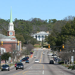
Aiken is the most populous city in, and the county seat of, Aiken County, South Carolina, United States. According to 2020 census, the population was 32,025, making it the 15th-most populous city in South Carolina, and one of the two largest cities of the Central Savannah River Area.

<span class="mw-page-title-main">Belvedere, South Carolina</span> Census-designated place in South Carolina, United States of America

Belvedere is a census-designated place (CDP) and suburb of North Augusta in Aiken County, South Carolina, United States. It is part of the Augusta, Georgia metropolitan area. The population was 5,792 at the 2010 census.

<span class="mw-page-title-main">Burnettown, South Carolina</span> Town in South Carolina, United States of America

Burnettown is a town in Aiken County, South Carolina, United States. The population was 3,105 at the 2020 census. It is part of the Augusta, Georgia metropolitan area. Burnettown is located in historic Horse Creek Valley.

<span class="mw-page-title-main">Clearwater, South Carolina</span> Census-designated place in South Carolina, United States of America

Clearwater is a census-designated place (CDP) in Aiken County, South Carolina. It lies near North Augusta, South Carolina, and is part of the Augusta, Georgia metropolitan area. Clearwater is located in historic Horse Creek Valley. The population was 4,370 at the time of the 2010 census.

<span class="mw-page-title-main">Gloverville, South Carolina</span> Census-designated place in South Carolina, United States of America

Gloverville is a census-designated place (CDP) in Aiken County, South Carolina, United States. The population was 2,831 at the 2010 census. It is part of the Augusta, Georgia metropolitan area. Gloverville is located in historic Horse Creek Valley.

<span class="mw-page-title-main">New Ellenton, South Carolina</span> City in South Carolina

New Ellenton is a city in Aiken County, South Carolina, United States. The population was 2,210 at the 2020 census. It is part of the Augusta, Georgia metropolitan area.

<span class="mw-page-title-main">Salley, South Carolina</span> Town in South Carolina, United States of America

Salley is a town in Aiken County, South Carolina, United States. The population was 398 at the 2010 census. It is part of the Augusta, Georgia metropolitan area. Salley is known for hosting the Chitlin Strut, a town-wide festival, every November.

<span class="mw-page-title-main">Barnwell, South Carolina</span> City in South Carolina, United States

Barnwell is a city in and county seat of Barnwell County, South Carolina, United States, located along U.S. Route 278. The population was 4,750 at the 2010 census.

<span class="mw-page-title-main">Johnston, South Carolina</span> Town in South Carolina, United States

Johnston is a town in Edgefield County, South Carolina, United States. The population was 2,362 at the 2010 census. It is part of the Augusta, Georgia, metropolitan area. The town's official welcome sign states that it is "Peach Capital of the World".

<span class="mw-page-title-main">Ridgeland, South Carolina</span> Town in South Carolina, United States

Ridgeland is a town in Jasper and Beaufort counties, South Carolina, United States. The population was 3,749 at the 2020 census, a 7.1% decrease from 2010. It has been the county seat of Jasper County since the county's formation in 1912. As defined by the U.S. Census Bureau, Ridgeland is included within the Hilton Head Island–Bluffton metropolitan area.

<span class="mw-page-title-main">Monetta, South Carolina</span> Town in South Carolina, United States of America

Monetta is a town in Aiken and Saluda counties, South Carolina, United States. The population was 236 at the 2010 census.

<span class="mw-page-title-main">Augusta, Georgia</span> Consolidated city-county in the United States

Augusta is a consolidated city-county on the central eastern border of the U.S. state of Georgia. The city lies directly across the Savannah River from North Augusta, South Carolina at the head of its navigable portion. Georgia's third most populous city, Augusta is located in the Fall Line section of the state.

<span class="mw-page-title-main">Augusta metropolitan area</span> Metropolitan Statistical Area in the United States

The Augusta metropolitan area, officially the Augusta-Richmond County metropolitan statistical area according to the U.S. Office of Management and Budget, Census Bureau and other agencies, is a metropolitan statistical area centered on the city of Augusta, Georgia. It straddles two U.S. states, Georgia and South Carolina, and includes the Georgia counties of Richmond, Burke, Columbia, Lincoln, and McDuffie as well as the South Carolina counties of Aiken and Edgefield. The official 2023 U.S. census estimate for the area was 629,429 residents, up from 611,000 at the 2020 U.S. census.

References

  1. "ArcGIS REST Services Directory". United States Census Bureau. Retrieved October 15, 2022.
  2. 1 2 "Census Population API". United States Census Bureau. Retrieved October 15, 2022.
  3. 1 2 "U.S. Census website". United States Census Bureau . Retrieved January 31, 2008.
  4. "US Board on Geographic Names". United States Geological Survey. October 25, 2007. Retrieved January 31, 2008.
  5. 1 2 "U.S. Census Bureau QuickFacts: North Augusta city, South Carolina". United States Census Bureau . Retrieved April 18, 2022.
  6. 1 2 "North Augusta". South Carolina Encyclopedia. Retrieved September 24, 2019.
  7. "National Register Information System". National Register of Historic Places . National Park Service. July 9, 2010.
  8. "North Augusta episode of 'My Big Fat American Gypsy Wedding' was most 'revelatory,' producer says". The Augusta Chronicle. Archived from the original on July 19, 2012.
  9. "Who are the Irish Travellers in the United States?". Pavee Point Travellers Centre. June 2005. Archived from the original on October 1, 2011. Retrieved July 20, 2011.
  10. Nike EYBLAdmission. Nike. Retrieved March 8, 2023.
  11. Girls Nike Nationals returns during Peach Jam, reigniting Augusta-area as premier basketball hub. The Augusta Chronicle'. Retrieved March 8, 2023.
  12. "US Gazetteer files: 2010, 2000, and 1990". United States Census Bureau. February 12, 2011. Retrieved April 23, 2011.
  13. "Geographic Identifiers: 2010 Demographic Profile Data (G001): North Augusta city, South Carolina". U.S. Census Bureau, American Factfinder. Archived from the original on February 10, 2020. Retrieved August 5, 2013.
  14. "South Carolina libraries and archives". SCIWAY. Retrieved June 7, 2019.
  15. "U.S. Decennial Census". Census.gov. Retrieved February 26, 2015.
  16. "Explore Census Data". data.census.gov. Retrieved December 14, 2021.