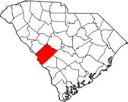
Perry, South Carolina

Last updated

Perry
Motto: 
p0content://media/external/file/4576 ZZsaGcp
SCMap-doton-Perry.PNG
Location of Perry, South Carolina
USA South Carolina location map.svg
Red pog.svg
Perry
Usa edcp location map.svg
Red pog.svg
Perry
Coordinates: 33°37′40″N81°18′40″W / 33.62778°N 81.31111°W / 33.62778; -81.31111
Country Flag of the United States.svg  United States of America
State Flag of South Carolina.svg  South Carolina
County Seal of Aiken County, South Carolina.png Aiken
Area
[1]
  Total0.96 sq mi (2.48 km2)
  Land0.96 sq mi (2.48 km2)
  Water0.00 sq mi (0.00 km2)
Elevation
440 ft (134 m)
Population
 (2020) [2]
  Total194
  Density202.51/sq mi (78.23/km2)
Time zone UTC-5 (Eastern (EST))
  Summer (DST) UTC-4 (EDT)
ZIP code
29137
Area code(s) 803, 839
FIPS code 45-55960 [3]
GNIS feature ID1231644 [4]

Perry is a town in Aiken County, South Carolina, United States. The population was 233 at the 2010 census. [5] It is part of the Augusta, Georgia metropolitan area.

Contents

Geography

Perry is located at 33°37′40″N81°18′40″W / 33.62778°N 81.31111°W / 33.62778; -81.31111 (33.627689, -81.311114) [6] in eastern Aiken County. It is 3 miles (5 km) east of the town of Wagener and 27 miles (43 km) east of the city of Aiken, the county seat. The town of Salley is 4 miles (6 km) to the south. A place called the Indian Head (springs) located just east of Pry on the Old Indian Trail. Site of an ancient Native American and colonial activity. It was on the Richard Davis tract of 1767.

According to the United States Census Bureau, the town has a total area of 1.2 square miles (3.0 km2), all land. [5]

Demographics

Historical population
CensusPop.Note
1890 69
1900 7610.1%
1910 179135.5%
1920 1895.6%
1930 166−12.2%
1940 141−15.1%
1950 133−5.7%
1960 19647.4%
1970 2096.6%
1980 27330.6%
1990 241−11.7%
2000 237−1.7%
2010 233−1.7%
2020 194−16.7%
U.S. Decennial Census [7] [2]

As of the census [3] of 2000, there were 237 people, 94 households, and 62 families residing in the town. The population density was 198.7 inhabitants per square mile (76.7/km2). There were 124 housing units at an average density of 104.0 per square mile (40.2/km2). The racial makeup of the town was 55.27% White, 44.30% African American and 0.42% Native American.

There were 94 households, out of which 34.0% had children under the age of 18 living with them, 38.3% were married couples living together, 23.4% had a female householder with no husband present, and 33.0% were non-families. 29.8% of all households were made up of individuals, and 7.4% had someone living alone who was 65 years of age or older. The average household size was 2.52 and the average family size was 3.16.

In the town, the population was spread out, with 31.2% under the age of 18, 7.6% from 18 to 24, 27.4% from 25 to 44, 24.5% from 45 to 64, and 9.3% who were 65 years of age or older. The median age was 33 years. For every 100 females, there were 80.9 males. For every 100 females age 18 and over, there were 79.1 males.

The median income for a household in the town was $23,750, and the median income for a family was $31,250. Males had a median income of $30,625 versus $23,000 for females. The per capita income for the town was $13,171. About 27.1% of families and 30.4% of the population were below the poverty line, including 51.3% of those under the age of eighteen and none of those 65 or over.

Related Research Articles

<span class="mw-page-title-main">Perry, Maine</span> Town in the state of Maine, United States

Perry is a town in Washington County, Maine, United States, on the Canada–United States border. At the 2020 census, the town had a population of 802.

<span class="mw-page-title-main">Chest Township, Cambria County, Pennsylvania</span> Township in Pennsylvania, United States

Chest Township is a township in Cambria County, Pennsylvania, United States. The population was 458 at the 2020 census. It is part of the Johnstown, Pennsylvania Metropolitan Statistical Area.

<span class="mw-page-title-main">Belvedere, South Carolina</span> Census-designated place in South Carolina, United States of America

Belvedere is a census-designated place (CDP) and suburb of North Augusta in Aiken County, South Carolina, United States. It is part of the Augusta, Georgia metropolitan area. The population was 5,792 at the 2010 census.

<span class="mw-page-title-main">Burnettown, South Carolina</span> Town in South Carolina, United States of America

Burnettown is a town in Aiken County, South Carolina, United States. The population was 3,105 at the 2020 census. It is part of the Augusta, Georgia metropolitan area. Burnettown is located in historic Horse Creek Valley.

<span class="mw-page-title-main">Clearwater, South Carolina</span> Census-designated place in South Carolina, United States of America

Clearwater is a census-designated place (CDP) in Aiken County, South Carolina. It lies near North Augusta, South Carolina, and is part of the Augusta, Georgia metropolitan area. Clearwater is located in historic Horse Creek Valley. The population was 4,370 at the time of the 2010 census.

<span class="mw-page-title-main">Gloverville, South Carolina</span> Census-designated place in South Carolina, United States of America

Gloverville is a census-designated place (CDP) in Aiken County, South Carolina, United States. The population was 2,831 at the 2010 census. It is part of the Augusta, Georgia metropolitan area. Gloverville is located in historic Horse Creek Valley.

<span class="mw-page-title-main">Jackson, South Carolina</span> Town in South Carolina, United States of America

Jackson is a town in Aiken County, South Carolina, United States. The population was 1,700 at the 2010 census. It is part of the Augusta, Georgia metropolitan area.

<span class="mw-page-title-main">New Ellenton, South Carolina</span> City in South Carolina

New Ellenton is a city in Aiken County, South Carolina, United States. The population was 2,210 at the 2020 census. It is part of the Augusta, Georgia metropolitan area.

<span class="mw-page-title-main">Salley, South Carolina</span> Town in South Carolina, United States of America

Salley is a town in Aiken County, South Carolina, United States. The population was 398 at the 2010 census. It is part of the Augusta, Georgia metropolitan area. Salley is known for hosting the Chitlin Strut, a town-wide festival, every November.

<span class="mw-page-title-main">Wagener, South Carolina</span> Town in South Carolina

Wagener is a town in Aiken County, South Carolina, United States. The population was 797 at the 2010 census, making it the largest settlement in the county north of the South Fork Edisto River. It is part of the Augusta, Georgia metropolitan area.

<span class="mw-page-title-main">Windsor, South Carolina</span> Town in South Carolina, United States of America

Windsor is a town in Aiken County, South Carolina, United States. The population was 121 at the 2010 census. It is part of the Augusta, Georgia metropolitan area.

<span class="mw-page-title-main">Blackville, South Carolina</span> Town in South Carolina, United States

Blackville is a small town in Barnwell County, South Carolina, United States. The population was 2,406 at the 2010 census.

<span class="mw-page-title-main">Hilda, South Carolina</span> Town in South Carolina, United States

Hilda is a town in Barnwell County, South Carolina, United States. The population was 447 at the 2010 census..

<span class="mw-page-title-main">Williston, South Carolina</span> Town in South Carolina, United States

Williston is a town in Barnwell County, South Carolina, United States. The population was 3,139 at the 2010 census.

<span class="mw-page-title-main">Little River, South Carolina</span> CDP in South Carolina, United States

Little River is a census-designated place (CDP) in Horry County, South Carolina, United States. The population was 11,711 at the 2020 census.

<span class="mw-page-title-main">Bancroft, West Virginia</span> Town in West Virginia, United States

Bancroft is a town in Putnam County, West Virginia, United States, along the Kanawha River. The population was 389 at the 2020 census. It is part of the Huntington–Ashland metropolitan area.

<span class="mw-page-title-main">Lester, West Virginia</span> Town in West Virginia, United States

Lester is a town in Raleigh County, West Virginia, United States. The population was 337 at the 2020 census. The community was named after Champ Lester, a local pioneer.

<span class="mw-page-title-main">Monetta, South Carolina</span> Town in South Carolina, United States of America

Monetta is a town in Aiken and Saluda counties, South Carolina, United States. The population was 236 at the 2010 census.

<span class="mw-page-title-main">North Augusta, South Carolina</span> City in South Carolina, United States

North Augusta is a city in Aiken and Edgefield counties in the U.S. state of South Carolina, on the north bank of the Savannah River. It lies directly across the river, and state border, from Augusta, Georgia. The population was 24,379 at the 2020 census, making it the 21st-most populous city in South Carolina. The city is included in the Central Savannah River Area (CSRA) and is part of the Augusta, Georgia, metropolitan area.

East Millinocket is a census-designated place (CDP) consisting of the main settlement in the town of East Millinocket in Penobscot County, Maine, United States. The population was 1,567 at the 2010 census.

References

  1. "ArcGIS REST Services Directory". United States Census Bureau. Retrieved October 15, 2022.
  2. 1 2 "Census Population API". United States Census Bureau. Retrieved October 15, 2022.
  3. 1 2 "U.S. Census website". United States Census Bureau . Retrieved January 31, 2008.
  4. "US Board on Geographic Names". United States Geological Survey. October 25, 2007. Retrieved January 31, 2008.
  5. 1 2 "Geographic Identifiers: 2010 Demographic Profile Data (G001): Perry town, South Carolina". U.S. Census Bureau, American Factfinder. Archived from the original on February 10, 2020. Retrieved August 5, 2013.
  6. "US Gazetteer files: 2010, 2000, and 1990". United States Census Bureau. February 12, 2011. Retrieved April 23, 2011.
  7. "Census of Population and Housing". Census.gov. Retrieved June 4, 2015.