Ulmer, South Carolina

Last updated

Ulmer
USA South Carolina location map.svg
Red pog.svg
Ulmer
Usa edcp location map.svg
Red pog.svg
Ulmer
North America laea location map.svg
Red pog.svg
Ulmer
Coordinates: 33°5′48″N81°12′28″W / 33.09667°N 81.20778°W / 33.09667; -81.20778
Country United States
State South Carolina
County Allendale
Area
[1]
  Total2.75 sq mi (7.13 km2)
  Land2.74 sq mi (7.09 km2)
  Water0.01 sq mi (0.03 km2)
Elevation
[2]
161 ft (49 m)
Population
 (2020) [3]
  Total65
  Density23.73/sq mi (9.16/km2)
Time zone UTC-5 (Eastern (EST))
  Summer (DST) UTC-4 (EDT)
ZIP code
29849
Area code(s) 803, 839
FIPS code 45-72880 [4]
GNIS feature ID1227276 [2]

Ulmer is a town in Allendale County, South Carolina, United States. The population was 65 at the 2020 census. [5]

Contents

History

The Williams House was added to the National Register of Historic Places in 1999. [6]

Geography

Ulmer is located at 33°5′48″N81°12′28″W / 33.09667°N 81.20778°W / 33.09667; -81.20778 (33.096652, -81.207712). [7]

According to the United States Census Bureau, the town has a total area of 2.7 square miles (7.1 km2), of which 0.012 square miles (0.03 km2), or 0.48%, is water. [5]

Demographics

Historical population
CensusPop.Note
1900 150
1910 19026.7%
1920 186−2.1%
1930 1997.0%
1940 169−15.1%
1950 139−17.8%
1960 16820.9%
1970 109−35.1%
1980 91−16.5%
1990 90−1.1%
2000 10213.3%
2010 88−13.7%
2020 65−26.1%
U.S. Decennial Census [8] [3]

2020 census

Ulmer racial composition
(Hispanics excluded from racial categories)
(NH = Non-Hispanic) [9]
RaceNumberPercentage
White (NH)3960.0%
Black or African American (NH)2335.38%
Mixed/Multi-Racial (NH)23.08%
Hispanic or Latino 11.54%
Total65

As of the 2020 United States census, there were 65 people, 23 households, and 8 families residing in the town.

2000 census

As of the census [4] of 2000, there were 102 people, 40 households, and 27 families living in the town. The population density was 103.9 inhabitants per square mile (40.1/km2). There were 54 housing units at an average density of 55.0 per square mile (21.2/km2). The racial makeup of the town was 85.29% White, 11.76% African American, 1.96% Native American, and 0.98% from two or more races.

There were 40 households, out of which 32.5% had children under the age of 18 living with them, 60.0% were married couples living together, 2.5% had a female householder with no husband present, and 32.5% were non-families. 27.5% of all households were made up of individuals, and 17.5% had someone living alone who was 65 years of age or older. The average household size was 2.55 and the average family size was 3.22.

In the town, the population was spread out, with 31.4% under the age of 18, 2.9% from 18 to 24, 28.4% from 25 to 44, 21.6% from 45 to 64, and 15.7% who were 65 years of age or older. The median age was 38 years. For every 100 females, there were 96.2 males. For every 100 females age 18 and over, there were 94.4 males.

The median income for a household in the town was $33,750, and the median income for a family was $53,333. Males had a median income of $26,667 versus $26,750 for females. The per capita income for the town was $16,363. There were 11.5% of families and 11.5% of the population living below the poverty line, including no under eighteens and 41.7% of those over 64.

Related Research Articles

<span class="mw-page-title-main">Allendale County, South Carolina</span> County in South Carolina, United States

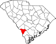
Allendale County is a county located in the U.S. state of South Carolina. As of the 2020 census, the population was 8,039, making it the least populous county in South Carolina. Its county seat is Allendale.

<span class="mw-page-title-main">Hornick, Iowa</span> City in Iowa, United States

Hornick is a city in Woodbury County, Iowa, United States. It is part of the Sioux City, IA–NE–SD metropolitan statistical area. The population was 255 at the time of the 2020 census.

<span class="mw-page-title-main">New Portland, Maine</span> Town in the state of Maine, United States

New Portland is a town in Somerset County, Maine, United States. It is perhaps best known for its Wire Bridge, a cable suspension bridge completed in 1866 that is the last remaining bridge of its type in Maine, and possibly the U.S. Much of North New Portland's Main Street burned to the ground in the fire of 1919, including a hotel. The annual town fair draws large crowds from around, and is held in September. The population was 765 at the 2020 census. The town was given to the residents of Falmouth by the Massachusetts legislature to repay them for their loss when the British fleet burned Falmouth in 1775.

<span class="mw-page-title-main">Algonquin, Maryland</span> Census-designated place in Maryland, United States

Algonquin is a census-designated place (CDP) in Dorchester County, Maryland, United States. The population was 1,241 at the 2010 census. The community was named for the Algonquin people, one of the Native American tribes in the East.

<span class="mw-page-title-main">Allendale, Missouri</span> Town in Missouri, United States

Allendale is a town in eastern Worth County, Missouri, United States. The population was 53 at the 2010 census, at which time it was a town.

<span class="mw-page-title-main">Thompson, North Dakota</span> City in North Dakota, United States

Thompson is a city in Grand Forks County, North Dakota, United States. It is part of the "Grand Forks, ND-MN Metropolitan Statistical Area" or "Greater Grand Forks". It is located on the border of Allendale and Walle townships, with Walle on the east and Allendale on the west. The population was 1,101 at the 2020 census. Thompson was founded in 1881.

<span class="mw-page-title-main">Karthaus Township, Clearfield County, Pennsylvania</span> Township in Pennsylvania, United States

Karthaus Township is a township in Clearfield County, Pennsylvania, United States. The population was 819 at the 2020 census.

Arlington Heights is a census-designated place (CDP) in Monroe County, Pennsylvania, United States. The population was 6,331 at the 2020 census. One notable location in Arlington Heights is the Stroud Mall.

<span class="mw-page-title-main">Troxelville, Pennsylvania</span> CDP in Pennsylvania, United States

Troxelville is a census-designated place (CDP) in Snyder County, Pennsylvania, United States. The population was 192 at the 2000 census.

<span class="mw-page-title-main">Fairfax, South Carolina</span> Town in South Carolina, United States

Fairfax is a town in Allendale and Hampton counties, South Carolina, United States. The population was 2,025 at the 2010 census, a decline of over one-third of its population of 3,206 from 2000.

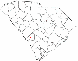
Sycamore is a town in Allendale County, South Carolina, United States. The population was 180 as of the 2010 census. On April 5, 2022, the town was hit by an EF3 tornado, although it had weakened to EF1 strength by the time it moved through town and only minor damage occurred. One person was injured by this tornado south of Allendale, South Carolina.

<span class="mw-page-title-main">Hilda, South Carolina</span> Town in South Carolina, United States

Hilda is a town in Barnwell County, South Carolina, United States. The population was 447 at the 2010 census..

<span class="mw-page-title-main">Kline, South Carolina</span> Town in South Carolina, United States

Kline is a town in Barnwell County, South Carolina, United States. The population was 197 at the 2010 census.

<span class="mw-page-title-main">Snelling, South Carolina</span> Town in South Carolina, United States

Snelling is a town in Barnwell County, South Carolina, United States. The population was 274 at the 2010 census.

<span class="mw-page-title-main">Furman, South Carolina</span> Town in South Carolina, United States

Furman is a town in Hampton County, South Carolina, United States. The population was 224 at the 2020 census, down from 239 at the 2010 census. It is not to be confused with Furman University, which is in Greenville, South Carolina.

<span class="mw-page-title-main">Bayside, Texas</span> Town in Texas, United States

Bayside is a town in southern Refugio County, in the U.S. state of Texas. The population was 325 at the 2010 census.

<span class="mw-page-title-main">Meadow, Texas</span> Town in Texas, United States

Meadow is a town in Terry County, Texas, United States. The population was 593 at the 2010 census.

<span class="mw-page-title-main">Leon, West Virginia</span> Town in West Virginia, United States

Leon is a town in Mason County, West Virginia, United States, situated along the Kanawha River. The population was 137 at the 2020 census. It is part of the Point Pleasant, WV–OH Micropolitan Statistical Area.

<span class="mw-page-title-main">Bancroft, West Virginia</span> Town in West Virginia, United States

Bancroft is a town in Putnam County, West Virginia, United States, along the Kanawha River. The population was 389 at the 2020 census. It is part of the Huntington–Ashland metropolitan area.

<span class="mw-page-title-main">Lester, West Virginia</span> Town in West Virginia, United States

Lester is a town in Raleigh County, West Virginia, United States. The population was 337 at the 2020 census. The community was named after Champ Lester, a local pioneer.

References

  1. "ArcGIS REST Services Directory". United States Census Bureau. Retrieved October 15, 2022.
  2. 1 2 U.S. Geological Survey Geographic Names Information System: Ulmer, South Carolina
  3. 1 2 "Census Population API". United States Census Bureau. Retrieved October 15, 2022.
  4. 1 2 "U.S. Census website". United States Census Bureau . Retrieved January 31, 2008.
  5. 1 2 "Geographic Identifiers: 2010 Demographic Profile Data (G001): Ulmer town, South Carolina". U.S. Census Bureau, American Factfinder. Archived from the original on February 12, 2020. Retrieved August 7, 2013.
  6. "National Register Information System". National Register of Historic Places . National Park Service. July 9, 2010.
  7. "US Gazetteer files: 2010, 2000, and 1990". United States Census Bureau. February 12, 2011. Retrieved April 23, 2011.
  8. "Census of Population and Housing". Census.gov. Retrieved June 4, 2015.
  9. "Explore Census Data". data.census.gov. Retrieved February 24, 2022.