New Ellenton, South Carolina

Last updated
New Ellenton, South Carolina
SCMap-doton-NewEllenton.PNG
Location of New Ellenton, South Carolina
Coordinates: 33°25′17″N81°40′51″W / 33.42139°N 81.68083°W / 33.42139; -81.68083 Coordinates: 33°25′17″N81°40′51″W / 33.42139°N 81.68083°W / 33.42139; -81.68083
Country Flag of the United States.svg  United States of America
State Flag of South Carolina.svg  South Carolina
County Seal of Aiken County, South Carolina.png Aiken
Area
[1]
  Total4.45 sq mi (11.51 km2)
  Land4.44 sq mi (11.50 km2)
  Water0.01 sq mi (0.01 km2)
Elevation
410 ft (125 m)
Population
 (2020) [2]
  Total2,210
  Density497.75/sq mi (192.17/km2)
Time zone UTC-5 (Eastern (EST))
  Summer (DST) UTC-4 (EDT)
ZIP code
29809
Area code(s) 803, 839
FIPS code 45-49705 [3]
GNIS feature ID1231587 [4]
Website www.newellentonsc.com

New Ellenton is a city in Aiken County, South Carolina, United States. The population was 2,210 at the 2020 census. [5] It is part of the Augusta, Georgia metropolitan area.

Contents

History

New Ellenton was formed from the citizens of Ellenton, a farming town chartered in 1880 and situated on the Charleston and Western Carolina Railway in Barnwell County near the Aiken County line. Upon the approval of President Truman in 1950 of the Savannah River Site for the production of hydrogen bombs, the U.S. government forced 6,000 people in the surrounding area to move. The residents of Ellenton literally moved their homes and buildings 14 miles (23 km) north to New Ellenton after being evicted in the 1950s.

Geography

New Ellenton is located at 33°25′17″N81°40′51″W / 33.42139°N 81.68083°W / 33.42139; -81.68083 (33.421311, −81.680856) [6] in southern Aiken County, about 1 mile (1.6 km) north of the U.S. Department of Energy Savannah River Site. South Carolina Highway 19 is Main Street for the community, leading north 10 miles (16 km) to Aiken, the county seat, and south 1 mile to U.S. Route 278, which leads west 17 miles (27 km) to Augusta, Georgia, and southeast 24 miles (39 km) to Barnwell.

According to the United States Census Bureau, the town has a total area of 4.8 square miles (12.4 km2), all land. [7]

Demographics

Historical population
CensusPop.Note
1960 2,309
1970 2,54610.3%
1980 2,6283.2%
1990 2,515−4.3%
2000 2,250−10.5%
2010 2,052−8.8%
2020 2,2107.7%
U.S. Decennial Census [8] [2]

2020 census

New Ellenton racial composition [9]
RaceNum.Perc.
White (non-Hispanic)1,19253.94%
Black or African American (non-Hispanic)78835.66%
Native American 20.09%
Asian 120.54%
Other/Mixed 1165.25%
Hispanic or Latino 1004.52%

As of the 2020 United States census, there were 2,210 people, 937 households, and 576 families residing in the town.

2000 census

As of the census [3] of 2000, there were 2,250 people, 876 households, and 616 families residing in the town. The population density was 449.4 inhabitants per square mile (173.5/km2). There were 1,079 housing units at an average density of 215.5 per square mile (83.2/km2). The racial makeup of the town was 60.62% White, 35.82% African American, 0.58% Native American, 0.36% Asian, 0.89% from other races, and 1.73% from two or more races. Hispanic or Latino of any race were 2.18% of the population.

There were 876 households, out of which 28.7% had children under the age of 18 living with them, 50.3% were married couples living together, 15.3% had a female householder with no husband present, and 29.6% were non-families. 26.4% of all households were made up of individuals, and 9.8% had someone living alone who was 65 years of age or older. The average household size was 2.54 and the average family size was 3.06.

In the town the population was spread out, with 24.8% under the age of 18, 8.1% from 18 to 24, 26.8% from 25 to 44, 23.8% from 45 to 64, and 16.4% who were 65 years of age or older. The median age was 39 years. For every 100 females, there were 91.8 males. For every 100 females age 18 and over, there were 87.3 males.

The median income for a household in the town was $38,125, and the median income for a family was $45,521. Males had a median income of $41,250 versus $21,810 for females. The per capita income for the town was $17,915. About 6.9% of families and 11.8% of the population were below the poverty line, including 16.3% of those under age 18 and 11.0% of those age 65 or over.


Education

New Ellenton has a public library, a branch of the ABBE Regional Library System. [10]

Related Research Articles

<span class="mw-page-title-main">Barnwell County, South Carolina</span> County in South Carolina, United States

Barnwell County is a county in the U.S. state of South Carolina. As of the 2020 census, its population was 20,589. Barnwell County is part of the Augusta-Richmond County, GA-SC Metropolitan Statistical Area. It is located in the Central Savannah River Area. Its county seat is Barnwell.

<span class="mw-page-title-main">Aiken County, South Carolina</span> County in South Carolina, United States

Aiken County is a county in the U.S. state of South Carolina. As of the 2020 census, its population was 168,808. Its county seat and largest city is Aiken. Aiken County is a part of the Augusta-Richmond County, GA-SC Metropolitan Statistical Area. It is mostly in the Sandhills region, with the northern parts reaching in the Piedmont and southern parts reaching into the Coastal Plain.

<span class="mw-page-title-main">Lowesville, North Carolina</span> Census-designated place in North Carolina, United States

Lowesville is a census-designated place (CDP) in Lincoln County, North Carolina, United States. The population was 2,945 at the 2010 census, up from 1,440 in 2000.

<span class="mw-page-title-main">Aiken, South Carolina</span> City in South Carolina, United States

Aiken is the largest city in, and the county seat of, Aiken County, in western South Carolina. It is one of the two largest cities of the Central Savannah River Area. Founded in 1835, Aiken was named after William Aiken, the president of the South Carolina Railroad. It became part of Aiken County when the county was formed in 1871 from parts of Orangeburg, Lexington, Edgefield, and Barnwell counties.

<span class="mw-page-title-main">Burnettown, South Carolina</span> Town in South Carolina, United States of America

Burnettown is a town in Aiken County, South Carolina, United States. The population was 3,105 at the 2020 census. It is part of the Augusta, Georgia metropolitan area. Burnettown is located in historic Horse Creek Valley.

<span class="mw-page-title-main">Clearwater, South Carolina</span> Census-designated place in South Carolina, United States of America

Clearwater is a census-designated place (CDP) in Aiken County, South Carolina. It lies near North Augusta, South Carolina, and is part of the Augusta, Georgia metropolitan area. Clearwater is located in historic Horse Creek Valley. The population was 4,370 at the time of the 2010 census.

<span class="mw-page-title-main">Gloverville, South Carolina</span> Census-designated place in South Carolina, United States of America

Gloverville is a census-designated place (CDP) in Aiken County, South Carolina, United States. The population was 2,831 at the 2010 census. It is part of the Augusta, Georgia metropolitan area. Gloverville is located in historic Horse Creek Valley.

<span class="mw-page-title-main">Jackson, South Carolina</span> Town in South Carolina, United States of America

Jackson is a town in Aiken County, South Carolina, United States. The population was 1,700 at the 2010 census. It is part of the Augusta, Georgia metropolitan area.

<span class="mw-page-title-main">Perry, South Carolina</span> Town in South Carolina, United States of America

Perry is a town in Aiken County, South Carolina, United States. The population was 233 at the 2010 census. It is part of the Augusta, Georgia metropolitan area.

<span class="mw-page-title-main">Olar, South Carolina</span> Town in South Carolina, United States

Olar is a town in Bamberg County, South Carolina, United States. The population was 257 at the 2010 census.

<span class="mw-page-title-main">Barnwell, South Carolina</span> City in South Carolina, United States

Barnwell is a city in and county seat of Barnwell County, South Carolina, United States, located along U.S. Route 278. The population was 4,750 at the 2010 census.

<span class="mw-page-title-main">Blackville, South Carolina</span> Town in South Carolina, United States

Blackville is a small town in Barnwell County, South Carolina, United States. The population was 2,406 at the 2010 census.

<span class="mw-page-title-main">Elko, South Carolina</span> Town in South Carolina, United States

Elko is a town in Barnwell County, South Carolina, United States. According to the 2010 census the population was 193.

<span class="mw-page-title-main">Hilda, South Carolina</span> Town in South Carolina, United States

Hilda is a town in Barnwell County, South Carolina, United States. The population was 447 at the 2010 census.

<span class="mw-page-title-main">Kline, South Carolina</span> Town in South Carolina, United States

Kline is a town in Barnwell County, South Carolina, United States. The population was 197 at the 2010 census.

<span class="mw-page-title-main">Snelling, South Carolina</span> Town in South Carolina, United States

Snelling is a town in Barnwell County, South Carolina, United States. The population was 274 at the 2010 census.

<span class="mw-page-title-main">Williston, South Carolina</span> Town in South Carolina, United States

Williston is a town in Barnwell County, South Carolina, United States. The population was 3,139 at the 2010 census.

<span class="mw-page-title-main">Furman, South Carolina</span> Town in South Carolina, United States

Furman is a town in Hampton County, South Carolina, United States. The population was 224 at the 2020 census, down from 239 at the 2010 census. It is not to be confused with Furman University, which is in Greenville, South Carolina.

<span class="mw-page-title-main">Monetta, South Carolina</span> Town in South Carolina, United States of America

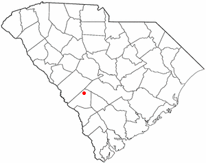
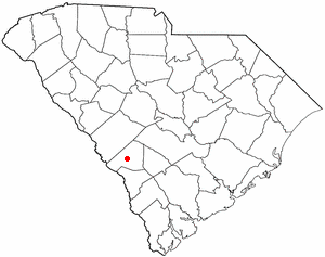
Monetta is a town in Aiken and Saluda counties, South Carolina, United States. The population was 236 at the 2010 census.

<span class="mw-page-title-main">Augusta metropolitan area</span> Metropolitan Statistical Area in Georgia South Carolina, United States

The Augusta metropolitan area is a metropolitan area in the U.S. states of Georgia and South Carolina centered on the principal city of Augusta. The U.S. Office of Management and Budget, Census Bureau and other agencies define Augusta's Metropolitan Statistical Area, the Augusta-Richmond County, GA-SC Metropolitan Statistical Area, as comprising Richmond, Burke, Columbia, Lincoln, McDuffie, Wilkes, Jefferson, Warren, Jenkins and Screven Counties in Georgia and Aiken, Edgefield, McCormick, Barnwell, Bamberg and Allendale Counties in South Carolina. In the official 2010 U.S. Census, the area had a population of 708,122. Its 2019 estimated population was 696,410.

References

  1. "ArcGIS REST Services Directory". United States Census Bureau. Retrieved October 15, 2022.
  2. 1 2 "Census Population API". United States Census Bureau. Retrieved Oct 15, 2022.
  3. 1 2 "U.S. Census website". United States Census Bureau . Retrieved 2008-01-31.
  4. "US Board on Geographic Names". United States Geological Survey. 2007-10-25. Retrieved 2008-01-31.
  5. U.S. Census Bureau, '2020 Census Results' https://www.census.gov/search-results.html?searchType=web&cssp=SERP&q=New%20Ellenton%20town,%20South%20Carolina
  6. "US Gazetteer files: 2010, 2000, and 1990". United States Census Bureau. 2011-02-12. Retrieved 2011-04-23.
  7. "Geographic Identifiers: 2010 Demographic Profile Data (G001): New Ellenton town, South Carolina". U.S. Census Bureau, American Factfinder. Archived from the original on February 10, 2020. Retrieved August 5, 2013.
  8. "Census of Population and Housing". Census.gov. Retrieved June 4, 2015.
  9. "Explore Census Data". data.census.gov. Retrieved 2021-12-14.
  10. "South Carolina libraries and archives". SCIWAY. Retrieved 7 June 2019.