Mount Carmel, South Carolina

Last updated

Mt. Carmel, South Carolina
CDP
McCormick County South Carolina incorporated and unincorporated areas Mount Carmel highlighted.svg
Location in McCormick County and the state of South Carolina.
Coordinates: 34°0′44″N82°30′25″W / 34.01222°N 82.50694°W / 34.01222; -82.50694
Country United States
State South Carolina
County McCormick
Area
[1]
  Total9.19 sq mi (23.80 km2)
  Land9.19 sq mi (23.80 km2)
  Water0.00 sq mi (0.00 km2)
Elevation
541 ft (165 m)
Population
 (2020) [2]
  Total156
  Density16.98/sq mi (6.55/km2)
Time zone UTC-5 (Eastern (EST))
  Summer (DST) UTC-4 (EDT)
ZIP code
29840
Area code 864
FIPS code 45-48310 [3]
GNIS feature ID1230047 [4]

Mt. Carmel is a census-designated place (CDP) in McCormick County, South Carolina, United States. The population was 237 at the 2000 census.

Contents

History

The Calhoun Mill and Mount Carmel Historic District are listed on the National Register of Historic Places. [5]

Geography

Mount Carmel is located at 34°0′44″N82°30′25″W / 34.01222°N 82.50694°W / 34.01222; -82.50694 (34.012272, -82.507075). [6]

According to the United States Census Bureau, the CDP has a total area of 9.2 square miles (23.8 km2), all land.

Demographics

Historical population
CensusPop.Note
2020 156
U.S. Decennial Census [7]

At the 2000 census there were 237 people, 86 households, and 63 families living in the CDP. The population density was 25.8 people per square mile (9.9/km2). There were 106 housing units at an average density of 11.5/sq mi (4.4/km2). The racial makeup of the CDP was 5.49% White, 89.87% African American, 1.27% Asian, and 3.38% from two or more races. Hispanic or Latino of any race were 1.69%. [3]

Of the 86 households 19.8% had children under the age of 18 living with them, 33.7% were married couples living together, 31.4% had a female householder with no husband present, and 25.6% were non-families. 24.4% of households were one person and 11.6% were one person aged 65 or older. The average household size was 2.76 and the average family size was 3.31.

The age distribution was 24.5% under the age of 18, 9.3% from 18 to 24, 26.2% from 25 to 44, 29.1% from 45 to 64, and 11.0% 65 or older. The median age was 38 years. For every 100 females, there were 94.3 males. For every 100 females age 18 and over, there were 92.5 males.

The median household income was $19,531 and the median family income was $28,500. Males had a median income of $34,375 versus $21,563 for females. The per capita income for the CDP was $9,777. About 46.8% of families and 48.8% of the population were below the poverty line, including 57.1% of those under the age of eighteen and 75.0% of those sixty five or over.

Related Research Articles

<span class="mw-page-title-main">Vine Hill, California</span> Census-designated place in California, United States

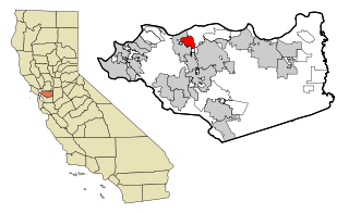
Vine Hill is a census-designated place (CDP) in Contra Costa County, California, United States. The population was 3,761 at the 2010 census. It is located 2.25 miles (3.6 km) east of downtown Martinez.

<span class="mw-page-title-main">Hydesville, California</span> Census-designated place in California, United States

Hydesville is a census-designated place (CDP) in Humboldt County, California, United States. Hydesville is located 4.5 miles (7.2 km) southeast of Fortuna, at an elevation of 364 feet (111 m). The population was 1,237 at the 2010 census, up from 1,209 at the 2000 census.

<span class="mw-page-title-main">Mono Vista, California</span> Census-designated place in California, United States

Mono Vista is a census-designated place (CDP) in Tuolumne County, California, United States. The population was 3,127 at the 2010 census, up from 3,072 at the 2000 census.

<span class="mw-page-title-main">Vamo, Florida</span> Census-designated place in Florida, United States

Vamo is a census-designated place (CDP) in Sarasota County, Florida, United States. The population was 4,727 at the 2010 census. It is part of the Bradenton–Sarasota–Venice Metropolitan Statistical Area.

<span class="mw-page-title-main">Charlotte Hall, Maryland</span> CDP in Maryland, United States

Charlotte Hall is a census-designated place (CDP) in Charles and St. Mary's counties, Maryland, United States. The population was 1,420 at the 2010 census. The Maryland Veterans Home for disabled veterans, including a U.S. Veterans Affairs clinic, is located on the site of the former Charlotte Hall Military Academy. The Academy site was declared the Charlotte Hall Historic District, and listed on the National Register of Historic Places in 1975. Since 1940, a sizable Amish farming community has existed nearby, along with a farmers' market and large flea market complex on Maryland Route 5, which is also the site of numerous strip-mall businesses continuing into the adjacent community of Mechanicsville.

<span class="mw-page-title-main">Marshfield Hills, Massachusetts</span> Census-designated place in Massachusetts, United States

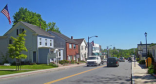
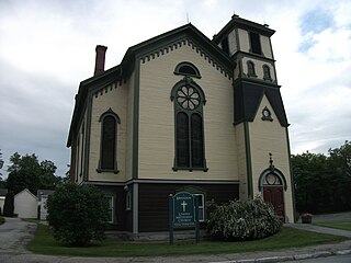
Marshfield Hills is a census-designated place (CDP) in the town of Marshfield in Plymouth County, Massachusetts, United States. The population was 2,356 at the 2010 census. The historic center of the village has been designated a historic district and listed on the National Register of Historic Places.

<span class="mw-page-title-main">Sheep Springs, New Mexico</span> CDP in New Mexico, United States

Sheep Springs is a census-designated place (CDP) in San Juan County, New Mexico, United States. The population was 237 at the 2000 census. It is part of the Farmington Metropolitan Statistical Area.

<span class="mw-page-title-main">Carmel Hamlet, New York</span> Hamlet and Census-designated place in New York, United States

Carmel Hamlet, commonly known simply as Carmel, is a hamlet and census-designated place (CDP) located in the Town of Carmel in Putnam County, New York, United States. As of the 2010 census, the population was 6,817.

<span class="mw-page-title-main">Barker Heights, North Carolina</span> Census-designated place in North Carolina, United States

Barker Heights is an unincorporated area and census-designated place (CDP) in Henderson County, North Carolina, United States. The population was 1,254 at the 2010 census. It is part of the Asheville Metropolitan Statistical Area.

<span class="mw-page-title-main">Mount Carmel, Ohio</span> Census-designated place in Ohio, United States

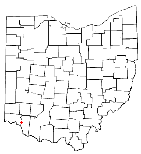
Mount Carmel is a census-designated place (CDP) in Clermont County, Ohio, United States. The population was 4,828 at the 2020 census.

<span class="mw-page-title-main">Berea, South Carolina</span> CDP in South Carolina, United States

Berea is a census-designated place (CDP) in Greenville County, South Carolina, United States. The population was 14,295 at the 2010 census. It is part of the Greenville–Mauldin–Easley Metropolitan Statistical Area.

<span class="mw-page-title-main">City View, South Carolina</span> Census-designated place in South Carolina, United States

City View, a former incorporated city, is now a census-designated place (CDP) in Greenville County, South Carolina, United States. The population was 1,345 at the 2010 census, up from 1,254 in 2000. It is part of the Greenville–Mauldin–Easley Metropolitan Statistical Area.

<span class="mw-page-title-main">Gantt, South Carolina</span> Census-designated place in South Carolina, United States

Gantt is a census-designated place (CDP) in Greenville County, South Carolina, United States. The population was 14,229 at the 2010 census. It is part of the Greenville–Mauldin–Easley Metropolitan Statistical Area and a suburb of the city of Greenville.

<span class="mw-page-title-main">Taylors, South Carolina</span> CDP in South Carolina, United States

Taylors is a census-designated place (CDP) in Greenville County, South Carolina, United States. The population was 21,617 at the 2010 census. Taylors is the Greenville/Spartanburg area's largest suburb although it is not incorporated as a city. It is part of the Greenville–Mauldin–Easley Metropolitan Statistical Area.

<span class="mw-page-title-main">Cokesbury, South Carolina</span> Census-designated place in South Carolina, United States

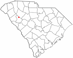
Cokesbury is a census-designated place (CDP) in Greenwood County, South Carolina, United States. The population was 215 at the 2010 census, down from 279 in 2000.

<span class="mw-page-title-main">Coronaca, South Carolina</span> Census-designated place in South Carolina, United States

Coronaca is an unincorporated community and census-designated place (CDP) in Greenwood County, South Carolina, United States. The population was 191 at the 2010 census.

<span class="mw-page-title-main">Clarks Hill, South Carolina</span> CDP in South Carolina, United States

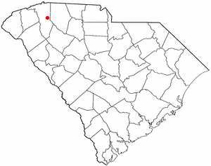
Clarks Hill is a census-designated place (CDP) in McCormick County, South Carolina, United States. The population was 376 at the 2000 census.

<span class="mw-page-title-main">St. Andrews, South Carolina</span> Census-designated place in South Carolina, United States

St. Andrews is a census-designated place (CDP) in Richland County, South Carolina, United States. The population was 20,493 at the 2010 census. It is part of the Columbia, South Carolina Metropolitan Statistical Area.

<span class="mw-page-title-main">Rembert, South Carolina</span> Town in South Carolina, United States

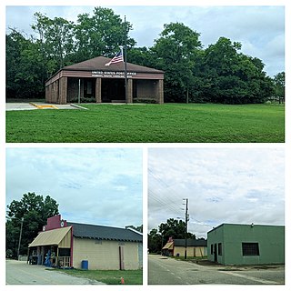
Rembert is a town in Sumter County, South Carolina, United States. The population was 306 at the 2010 census, a decline from 406 in 2000. It is included in the Sumter, South Carolina Metropolitan Statistical Area.

<span class="mw-page-title-main">Brandon (CDP), Vermont</span> CDP in Vermont, United States

Brandon is an unincorporated village and census-designated place (CDP) in the town of Brandon, Rutland County, Vermont, United States. As of the 2020 census, the population was 1,727.

References

  1. "ArcGIS REST Services Directory". United States Census Bureau. Retrieved October 15, 2022.
  2. "Census Population API". United States Census Bureau. Retrieved October 15, 2022.
  3. 1 2 "U.S. Census website". United States Census Bureau . Retrieved January 31, 2008.
  4. "US Board on Geographic Names". United States Geological Survey. October 25, 2007. Retrieved January 31, 2008.
  5. "National Register Information System". National Register of Historic Places . National Park Service. July 9, 2010.
  6. "US Gazetteer files: 2010, 2000, and 1990". United States Census Bureau. February 12, 2011. Retrieved April 23, 2011.
  7. "Census of Population and Housing". Census.gov. Retrieved June 4, 2016.