Warrenville, South Carolina

Last updated
Warrenville, South Carolina
USA South Carolina location map.svg
Red pog.svg
Warrenville
Coordinates: 33°33′3″N81°48′14″W / 33.55083°N 81.80389°W / 33.55083; -81.80389
Country Flag of the United States.svg  United States of America
State Flag of South Carolina.svg  South Carolina
County Seal of Aiken County, South Carolina.png Aiken
Area
[1]
  Total1.09 sq mi (2.83 km2)
  Land1.08 sq mi (2.81 km2)
  Water0.01 sq mi (0.02 km2)
Elevation
235 ft (72 m)
Population
 (2020) [2]
  Total1,134
  Density1,046.13/sq mi (403.74/km2)
Time zone UTC-5 (Eastern (EST))
  Summer (DST) UTC-4 (EDT)
ZIP code
29851
Area code(s) 803 and 839
FIPS code 45-74725 [3]
GNIS feature ID1231893 [4]

Warrenville is a census-designated place (CDP) in Aiken County, South Carolina, United States. The population was 1,233 at the 2010 census. [5] It is located just south of Graniteville and is part of the Augusta, Georgia metropolitan area. Warrenville is located in historic Horse Creek Valley.

Contents

History

In 2008, there were talks about incorporating the villages of Warrenville, Graniteville, and Vaucluse; as a result, the towns approved a referendum to vote on whether or not to incorporate. [6] If approved, the municipality would have had an area of around 20 square miles (52 km2). [7] The referendum was defeated by a two-to-one margin in August 2008.

The Warrenville Elementary School was listed on the National Register of Historic Places in 2002. [8]

Demographics

Historical population
CensusPop.Note
2020 1,134
U.S. Decennial Census [9]

The Demographics of the CDP as of 2010 were as follows: Counts Percentages Total Population 1,233 100.00%

Population by Race: American Indian and Alaska native alone 11 (0.89%) Asian alone 3 (0.24%) Black or African American alone 66 (5.35%) Native Hawaiian and Other Pacific native alone 0 (0.0%) Some other race alone 50 (4.06%) Two or more races 45 (3.65%) White alone 1,058 (85.81%)

Population by Hispanic or Latino Origin: (of any race) Persons of Hispanic or Latino Origin 84 (6.81%) Persons Not of Hispanic or Latino Origin 1,149 (93.19%)

Population by Gender Male 580 (47.04%) Female 653 (52.96%)

Population by Age Persons 0 to 4 years 65 (5.27%) Persons 5 to 17 years 205 (16.63%) Persons 18 to 64 years 732 (59.37%) Persons 65 years and over 231 (18.73%) [10]

Education

Warrenville has a public library, a branch of the ABBE Regional Library System. [11]

Related Research Articles

<span class="mw-page-title-main">Aiken County, South Carolina</span> County in South Carolina, United States

Aiken County is a county in the U.S. state of South Carolina. As of the 2020 census, its population was 168,808. Its county seat and largest city is Aiken. Aiken County is a part of the Augusta-Richmond County, GA-SC Metropolitan Statistical Area. It is mostly in the Sandhills region, with the northern parts reaching in the Piedmont and southern parts reaching into the Coastal Plain.

<span class="mw-page-title-main">South Apopka, Florida</span> Census-designated place in Florida, United States

South Apopka is a census-designated place and an unincorporated area in Orange County, Florida, United States. Per the 2020 census, the population was 6,803. It is part of the Orlando–Kissimmee Metropolitan Statistical Area.

<span class="mw-page-title-main">Experiment, Georgia</span> CDP in Georgia, United States

Experiment is a census-designated place (CDP) in Spalding County, Georgia, United States. The population was 3,233 at the 2000 census.

<span class="mw-page-title-main">Rosaryville, Maryland</span> Census-designated place in Maryland

Rosaryville is an unincorporated area and census-designated place (CDP) in Prince George's County, Maryland, United States, located south of Cinton and Upper Marlboro beside U.S. Route 301. Per the 2020 census, the population was 11,548. including housing developments and rural open space. It was named for a local Roman Catholic church. Close to Rosaryville are the Marlton housing development, Maryland Veterans Cemetery, the Southern Maryland Farmers Market, and Rosaryville State Park.

<span class="mw-page-title-main">Plainsboro Center, New Jersey</span> Census-designated place in New Jersey, United States

Plainsboro Center is an unincorporated community and census-designated place (CDP) located within Plainsboro Township, in Middlesex County, New Jersey, United States. As of the 2010 United States Census, the CDP's population was 2,712.

St. Bonaventure is a hamlet and census-designated place (CDP) in the town of Allegany in Cattaraugus County, New York, United States. The population was 1,963 at the 2020 census.

<span class="mw-page-title-main">Belvedere, South Carolina</span> Census-designated place in South Carolina, United States of America

Belvedere is a census-designated place (CDP) and suburb of North Augusta in Aiken County, South Carolina, United States. It is part of the Augusta, Georgia metropolitan area. The population was 5,792 at the 2010 census.

<span class="mw-page-title-main">Burnettown, South Carolina</span> Town in South Carolina, United States of America

Burnettown is a town in Aiken County, South Carolina, United States. The population was 3,105 at the 2020 census. It is part of the Augusta, Georgia metropolitan area. Burnettown is located in historic Horse Creek Valley.

<span class="mw-page-title-main">Clearwater, South Carolina</span> Census-designated place in South Carolina, United States of America

Clearwater is a census-designated place (CDP) in Aiken County, South Carolina. It lies near North Augusta, South Carolina, and is part of the Augusta, Georgia metropolitan area. Clearwater is located in historic Horse Creek Valley. The population was 4,370 at the time of the 2010 census.

<span class="mw-page-title-main">Gloverville, South Carolina</span> Census-designated place in South Carolina, United States of America

Gloverville is a census-designated place (CDP) in Aiken County, South Carolina, United States. The population was 2,831 at the 2010 census. It is part of the Augusta, Georgia metropolitan area. Gloverville is located in historic Horse Creek Valley.

<span class="mw-page-title-main">Windsor, South Carolina</span> Town in South Carolina, United States of America

Windsor is a town in Aiken County, South Carolina, United States. The population was 121 at the 2010 census. It is part of the Augusta, Georgia metropolitan area.

<span class="mw-page-title-main">Promised Land, South Carolina</span> Census-designated place in South Carolina, United States

Promised Land is an unincorporated community and census-designated place (CDP) in Greenwood County, South Carolina, United States. The population was 511 at the 2010 census.

<span class="mw-page-title-main">St. Andrews, South Carolina</span> Census-designated place in South Carolina, United States

St. Andrews is a census-designated place (CDP) in Richland County, South Carolina, United States. The population was 20,493 at the 2010 census. It is part of the Columbia, South Carolina Metropolitan Statistical Area.

<span class="mw-page-title-main">Agua Dulce, El Paso County, Texas</span> Census-designated place in Texas, United States

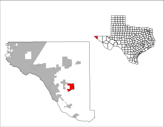
Agua Dulce is a census-designated place (CDP) in El Paso County, Texas, United States. The population was 3,218 at the 2020 census. It is part of the El Paso Metropolitan Statistical Area. The ZIP Code encompassing the CDP area is 79928.

<span class="mw-page-title-main">Rendon, Texas</span> CDP in Texas, United States

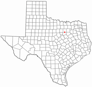
Rendon is a census-designated place (CDP) in Tarrant County, Texas, United States. The population was 12,552 at the 2010 census.

<span class="mw-page-title-main">Monetta, South Carolina</span> Town in South Carolina, United States of America

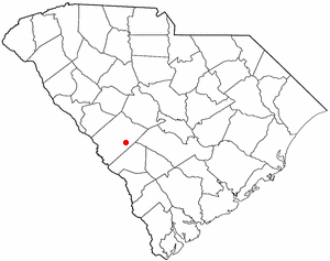
Monetta is a town in Aiken and Saluda counties, South Carolina, United States. The population was 236 at the 2010 census.

Pecan Acres is a census-designated place (CDP) in Tarrant and Wise counties in the U.S. state of Texas. The population was 4,099 at the 2010 census.

<span class="mw-page-title-main">Graniteville, South Carolina</span> Census-designated place in South Carolina, United States of America

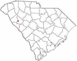
Graniteville is a census-designated place (CDP) in Aiken County, South Carolina, United States. The population was 2,614 at the 2010 census. It lies along U.S. Route 1, five miles (8.0 km) west of Aiken in Horse Creek Valley, which originates in the nearby town of Vaucluse.

<span class="mw-page-title-main">Baltimore Highlands, Maryland</span> Census-designated place in Maryland, United States

Baltimore Highlands is a census-designated place (CDP) in Baltimore County, Maryland, United States, directly south of the city of Baltimore. The population was 7,019 at the 2010 census. At the 2000 census and earlier, the area was delineated as part of the Lansdowne-Baltimore Highlands CDP.

Langley is a census-designated place (CDP) in Aiken County, South Carolina, United States. The population was 1,447 at the 2010 census. It is bordered by Gloverville to the northeast and Burnettown to the west.

References

  1. "ArcGIS REST Services Directory". United States Census Bureau. Retrieved October 15, 2022.
  2. "Census Population API". United States Census Bureau. Retrieved Oct 15, 2022.
  3. "U.S. Census website". United States Census Bureau . Retrieved 2008-01-31.
  4. "US Board on Geographic Names". United States Geological Survey. 2007-10-25. Retrieved 2008-01-31.
  5. "Geographic Identifiers: 2010 Demographic Profile Data (G001): Warrenville CDP, South Carolina". U.S. Census Bureau, American Factfinder. Archived from the original on February 12, 2020. Retrieved August 7, 2013.
  6. "Error". Archived from the original on 2007-04-21. Retrieved 2007-12-17.
  7. http://www.aikenstandard.com/homepage/292568584395065.php [ dead link ]
  8. "National Register Information System". National Register of Historic Places . National Park Service. July 9, 2010.
  9. "Census of Population and Housing". Census.gov. Retrieved June 4, 2016.
  10. "2010 Census Population of Warrenville, South Carolina - CensusViewer".
  11. "South Carolina libraries and archives". SCIWAY. Retrieved 7 June 2019.