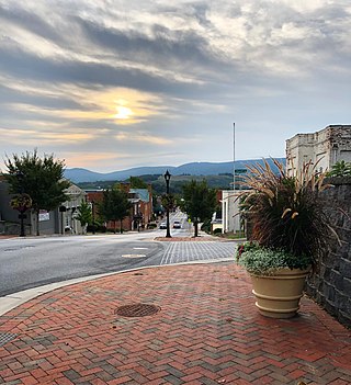
Waynesboro is an independent city in the Commonwealth of Virginia. It is a principal city of the Staunton-Waynesboro Metropolitan Statistical Area. Waynesboro is located in the Shenandoah Valley and is surrounded by Augusta County. As of the 2020 census, the population was 22,196.

Richmond County is a county located in the U.S. state of Georgia. As of the 2020 census, the population was 206,607. It is one of the original counties of Georgia, created February 5, 1777. Following an election in 1995, the city of Augusta consolidated governments with Richmond County. The consolidated entity is known as Augusta-Richmond County, or simply Augusta. Exempt are the cities of Hephzibah and Blythe, in southern Richmond County, which voted to remain separate. Richmond County is included in the Augusta-Richmond County, GA-SC metropolitan statistical area.

Jenkins County is a county located in the southeastern area of the U.S. state of Georgia. As of the 2020 census, the population was 8,674. The county seat is Millen. Historic and bountiful Magnolia Springs State Park is located between Millen and Perkins.

Jefferson County is a county located in the U.S. state of Georgia. As of the 2020 census, the population was 15,709. The county seat and largest city is Louisville. The county was created on February 20, 1796, and named for Thomas Jefferson, the main author of the Declaration of Independence who became the third president of the United States.

Columbia County is a county located in the east central portion of the U.S. state of Georgia. As of the 2020 census, the population was 156,010. The legal county seat is Appling, but the de facto seat of county government is Evans.

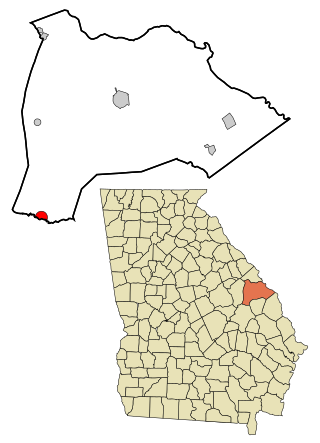
Burke County is a county located along the eastern border of the U.S. state of Georgia in the Piedmont. As of the 2020 census, the population was 24,596. The county seat is Waynesboro. Burke County is part of the Augusta-Richmond County, GA-SC metropolitan statistical area.

Winder is a city and the county seat of Barrow County, Georgia, United States. It is located east of Atlanta and is part of the Atlanta metropolitan area. The population was 18,338 at the 2020 census.
Midville is a city in Burke County, Georgia, United States. The population was 269 at the 2010 census, and 385 in 2020. It is part of the Augusta, Georgia metropolitan area.

Sardis is a city in Burke County, Georgia, United States. The population is 995 in 2020. It is part of the Augusta, Georgia metropolitan area in the Central Savannah River Area (CSRA).

Vidette is a city in Burke County, Georgia, United States. The population was 103 in 2020. It is part of the Augusta, Georgia metropolitan area.

Rincon is a city in Effingham County, Georgia, United States. The 2020 population was 10,934, up from 8,836 at the 2010 census. Rincon is part of the Savannah metropolitan statistical area.

Louisville is a city in and the county seat of Jefferson County, Georgia, United States, and also a former state capital of Georgia. It is located southwest of Augusta on the Ogeechee River, and its population was 2,493 at the 2010 census, down from 2,712 at the 2000 census. By 2020, its population was 2,381. Its name is pronounced "Lewis-ville", though it and the differently pronounced city in Kentucky were both named for Louis XVI.

Wrens is a city in Jefferson County, Georgia, United States. The population was 2,217 at the 2020 census. It is located on U.S. Route 1, thirty miles south of Augusta.

Millen is a city, and the county seat of Jenkins County, Georgia, United States. The population was 3,120 at the 2010 census, down from 3,492 at the 2000 census.

Lincolnton is a city and the county seat of Lincoln County, Georgia, United States. The population was 1,480 at the 2020 census. It contains numerous houses and historic districts listed on the National Register of Historic Places. Both the city and the county were named for General Benjamin Lincoln, who served in the Continental Army during the American Revolution.

The Savannah River is a major river in the Southeastern United States, forming most of the border between South Carolina and Georgia. Two tributaries of the Savannah, the Tugaloo River and the Chattooga River, form the northernmost part of the state border. The Savannah River drainage basin extends into the southeastern side of the Appalachian Mountains just inside North Carolina, bounded by the Eastern Continental Divide. The river is around 301 miles (484 km) long. The Savannah was formed by the confluence of the Tugaloo River and the Seneca River. Today this confluence is part of Lake Hartwell. The Tallulah Gorge is located on the Tallulah River, a tributary of the Tugaloo River that forms the northwest branch of the Savannah River.

Augusta is a consolidated city-county on the central eastern border of the U.S. state of Georgia. The city lies directly across the Savannah River from North Augusta, South Carolina at the head of its navigable portion. Georgia's third most populous city, Augusta is located in the Fall Line section of the state.

The Alvin W. Vogtle Electric Generating Plant, also known as Plant Vogtle, is a four-unit nuclear power plant located in Burke County, near Waynesboro, Georgia, in the southeastern United States.

The Central Savannah River Area (CSRA) is an unofficial trading and marketing region in the U.S. states of Georgia and South Carolina, spanning thirteen counties in Georgia and seven in South Carolina. The term was coined in 1950 by C.C. McCollum, the winner of a $250 contest held by The Augusta Chronicle to generate the best name for the area. Today the initialism is so commonly used that the full name is not known to all CSRA residents. The region is located on and named after the Savannah River, which forms the border between the two states. The largest cities within the CSRA are Augusta, Georgia and Aiken, South Carolina. (The CSRA does not include the city of Savannah, Georgia or any portion of the Savannah metropolitan area.)
The Augusta metropolitan area, officially the Augusta-Richmond County metropolitan statistical area according to the U.S. Office of Management and Budget, Census Bureau and other agencies, is a metropolitan statistical area centered on the city of Augusta, Georgia. It straddles two U.S. states, Georgia and South Carolina, and includes the Georgia counties of Richmond, Burke, Columbia, Lincoln, and McDuffie as well as the South Carolina counties of Aiken and Edgefield. The official 2022 U.S. census estimate for the area was 624,083 residents, up from 611,000 at the 2020 U.S. census.


