Wagener, South Carolina

Last updated

Wagener
WagenerSouthCrolina.jpg
Nickname: 
Gaigeville
SCMap-doton-Wagener.PNG
Location of Wagener, South Carolina
Coordinates: 33°39′10″N81°21′51″W / 33.65278°N 81.36417°W / 33.65278; -81.36417
Country Flag of the United States.svg  United States of America
State Flag of South Carolina.svg  South Carolina
County Seal of Aiken County, South Carolina.png Aiken
Area
[1]
  Total1.35 sq mi (3.49 km2)
  Land1.34 sq mi (3.47 km2)
  Water0.01 sq mi (0.02 km2)
Elevation
466 ft (142 m)
Population
 (2020) [2]
  Total631
  Density470.90/sq mi (181.80/km2)
Time zone UTC-5 (Eastern (EST))
  Summer (DST) UTC-4 (EDT)
ZIP code
29164
Area code(s) 803, 839
FIPS code 45-74050 [3]
GNIS feature ID1251308 [4]
Website www.wagenersc.com

Wagener is a town in Aiken County, South Carolina, United States. The population was 797 at the 2010 census, making it the largest settlement in the county north of the South Fork Edisto River. [5] It is part of the Augusta, Georgia metropolitan area.

Contents

Geography

Wagener is located in eastern Aiken County at 33°39′10″N81°21′51″W / 33.65278°N 81.36417°W / 33.65278; -81.36417 (33.652701, -81.364187). [6]

According to the United States Census Bureau, the town has a total area of 1.2 square miles (3.1 km2), of which 0.008 square miles (0.02 km2), or 0.60%, is water. [5]

Demographics

Historical population
CensusPop.Note
1900 192
1910 36288.5%
1920 59764.9%
1930 546−8.5%
1940 5887.7%
1950 584−0.7%
1960 6145.1%
1970 72317.8%
1980 90324.9%
1990 731−19.0%
2000 86318.1%
2010 797−7.6%
2020 631−20.8%
U.S. Decennial Census [7] [2]

2020 census

Wagener racial composition [8]
RaceNum.Perc.
White (non-Hispanic)22635.82%
Black or African American (non-Hispanic)36858.32%
Native American 30.48%
Asian 10.16%
Pacific Islander 10.16%
Other/Mixed 253.96%
Hispanic or Latino 71.11%

As of the 2020 United States census, there were 631 people, 320 households, and 261 families residing in the town.

2012

As of the census [3] of 2012, there were 809 people, 368 (45.5%) males, and 441 (54.5%) females. Median resident age was 38.4

2000 census

As of the census [3] of 2000, there were 863 people, 347 households, and 239 families residing in the town. The population density was 685.1 inhabitants per square mile (264.5/km2). There were 424 housing units at an average density of 336.6 per square mile (130.0/km2). The racial makeup of the town was 61.53% African American, 37.54% White, 0.35% Asian, and 0.58% from two or more races. Hispanic or Latino of any race were 0.93% of the population.

There were 347 households, out of which 32.6% had children under the age of 18 living with them, 38.0% were married couples living together, 26.2% had a female householder with no husband present, and 31.1% were non-families. 27.4% of all households were made up of individuals, and 13.0% had someone living alone who was 65 years of age or older. The average household size was 2.49 and the average family size was 3.04.

In the town, the population was spread out, with 28.2% under the age of 18, 9.4% from 18 to 24, 26.4% from 25 to 44, 22.6% from 45 to 64, and 13.4% who were 65 years of age or older. The median age was 36 years. For every 100 females, there were 88.0 males. For every 100 females age 18 and over, there were 81.8 males.

The median income for a household in the town was $24,773, and the median income for a family was $29,833. Males had a median income of $28,182 versus $17,212 for females. The per capita income for the town was $13,805. About 15.2% of families and 17.9% of the population were below the poverty line, including 25.0% of those under age 18 and 18.4% of those age 65 or over

History

Gunter's Crossroad The history of Wagener dates back to 1887. The early settlement was known as Pinder Town and later as Guntersville or Gunter's Crossroad, after the large number of North Carolinian settlers named Gunter. These men helped make up Company I of the 20th SC Infantry, which was part of Kershaw's Brigade during the Civil War. The town is situated on what was once farm land belonging to Elridge Gunter. He donated this property to benefit the schools of Wagener and the First Baptist Church.

The Southern Railroad The little town grew when the Southern Railroad ran a line through to Batesburg. Nearly all of the towns that sprang up along the railroad wanted to use the last name of George Wagener, who was a strong supporter of the railroad and the owner of a wholesale house in Charleston. It was through the influence of J. A. Gunter, a prosperous local farmer, that the town received the honor of using this distinguished name.

In the 1920s and 1930s, asparagus was grown here and exported across America. During the same period, cotton became a successful product and huge bales lined the streets awaiting departure via train. The children of Wagener frolicked among the hay bales during their games of hide-n-seek. A central town park is located where the railroad beds were.

Education

Wagener has a public library, a branch of the ABBE Regional Library System. [9]

Related Research Articles

<span class="mw-page-title-main">Camp Hill, Alabama</span> Town in Alabama, United States

Camp Hill is a town in Tallapoosa County, Alabama, United States. It was incorporated in 1895. At the 2010 census the population was 1,014, down from 1,273 in 2000. Camp Hill is the home to Southern Preparatory Academy.

Moose River is a town in Somerset County, Maine, United States. The population was 188 at the 2020 census. It was first settled by Capt. Samuel Holden who in 1820 opened an inn as a stop for cattle drivers en route from Boston to Quebec.

<span class="mw-page-title-main">Conception Junction, Missouri</span> City in Missouri, United States

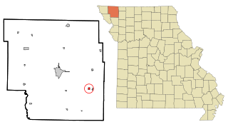
Conception Junction is a city in Nodaway County, Missouri, United States, near the Platte River. The population was 177 at the 2020 census.

<span class="mw-page-title-main">Howard, New York</span> Town in New York, United States

Howard is a town in Steuben County, New York, United States. The population was 1,380 at the 2020 census.

<span class="mw-page-title-main">Walton Hills, Ohio</span> Village in Ohio, United States

Walton Hills is a village in Cuyahoga County, Ohio, United States. The population was 2,033 at the 2020 census. A suburb of Cleveland, it is a part of the Cleveland metropolitan area.

<span class="mw-page-title-main">Burnettown, South Carolina</span> Town in South Carolina, United States of America

Burnettown is a town in Aiken County, South Carolina, United States. The population was 3,105 at the 2020 census. It is part of the Augusta, Georgia metropolitan area. Burnettown is located in historic Horse Creek Valley.

<span class="mw-page-title-main">Clearwater, South Carolina</span> Census-designated place in South Carolina, United States of America

Clearwater is a census-designated place (CDP) in Aiken County, South Carolina. It lies near North Augusta, South Carolina, and is part of the Augusta, Georgia metropolitan area. Clearwater is located in historic Horse Creek Valley. The population was 4,370 at the time of the 2010 census.

<span class="mw-page-title-main">Gloverville, South Carolina</span> Census-designated place in South Carolina, United States of America

Gloverville is a census-designated place (CDP) in Aiken County, South Carolina, United States. The population was 2,831 at the 2010 census. It is part of the Augusta, Georgia metropolitan area. Gloverville is located in historic Horse Creek Valley.

<span class="mw-page-title-main">Jackson, South Carolina</span> Town in South Carolina, United States of America

Jackson is a town in Aiken County, South Carolina, United States. The population was 1,700 at the 2010 census. It is part of the Augusta, Georgia metropolitan area.

<span class="mw-page-title-main">New Ellenton, South Carolina</span> City in South Carolina

New Ellenton is a city in Aiken County, South Carolina, United States. The population was 2,210 at the 2020 census. It is part of the Augusta, Georgia metropolitan area.

<span class="mw-page-title-main">Perry, South Carolina</span> Town in South Carolina, United States of America

Perry is a town in Aiken County, South Carolina, United States. The population was 233 at the 2010 census. It is part of the Augusta, Georgia metropolitan area.

<span class="mw-page-title-main">Salley, South Carolina</span> Town in South Carolina, United States of America

Salley is a town in Aiken County, South Carolina, United States. The population was 398 at the 2010 census. It is part of the Augusta, Georgia metropolitan area. Salley is known for hosting the Chitlin Strut, a town-wide festival, every November.

<span class="mw-page-title-main">Windsor, South Carolina</span> Town in South Carolina, United States of America

Windsor is a town in Aiken County, South Carolina, United States. The population was 121 at the 2010 census. It is part of the Augusta, Georgia metropolitan area.

<span class="mw-page-title-main">Blackville, South Carolina</span> Town in South Carolina, United States

Blackville is a small town in Barnwell County, South Carolina, United States. The population was 2,406 at the 2010 census.

<span class="mw-page-title-main">Williston, South Carolina</span> Town in South Carolina, United States

Williston is a town in Barnwell County, South Carolina, United States. The population was 3,139 at the 2010 census.

<span class="mw-page-title-main">Pelion, South Carolina</span> Town in South Carolina, United States

Pelion is a town in Lexington County, South Carolina, United States. The population was 674 at the 2010 census. It is part of the Columbia, South Carolina Metropolitan Statistical Area.

Springdale is a town in Lexington County, South Carolina, United States. The population was 2,636 at the 2010 census. It is part of the Columbia Metropolitan Statistical Area.

<span class="mw-page-title-main">Ellenboro, West Virginia</span> Town in West Virginia, United States

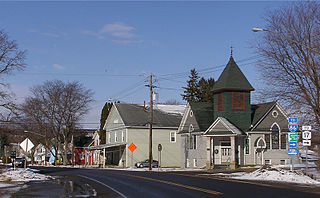
Ellenboro is a town in Ritchie County, West Virginia, United States. The population was 222 at the 2020 census. The town is located at the junction of U.S. Route 50 and West Virginia Route 16; the North Bend Rail Trail also passes through the town. The town was named for Ellen Mariah Williamson, the eldest daughter of the family that granted a right of way for the Baltimore and Ohio Railroad to build their line through the town; an earlier name for the community was Shumley. Ellenboro was incorporated in 1903.

<span class="mw-page-title-main">Monetta, South Carolina</span> Town in South Carolina, United States of America

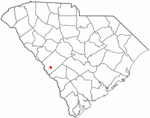
Monetta is a town in Aiken and Saluda counties, South Carolina, United States. The population was 236 at the 2010 census.

<span class="mw-page-title-main">Hillsboro, Wisconsin</span> City in Wisconsin, United States

Hillsboro is a city in Vernon County, Wisconsin, United States. The population was 1,397 at the 2020 Census. The city is located within the Town of Hillsboro. Hillsboro is known as the Czech Capital of Wisconsin.

References

  1. "ArcGIS REST Services Directory". United States Census Bureau. Retrieved October 15, 2022.
  2. 1 2 "Census Population API". United States Census Bureau. Retrieved October 15, 2022.
  3. 1 2 3 "U.S. Census website". United States Census Bureau . Retrieved January 31, 2008.
  4. "US Board on Geographic Names". United States Geological Survey. October 25, 2007. Retrieved January 31, 2008.
  5. 1 2 "Geographic Identifiers: 2010 Demographic Profile Data (G001): Wagener town, South Carolina". U.S. Census Bureau, American Factfinder. Archived from the original on February 12, 2020. Retrieved August 6, 2013.
  6. "US Gazetteer files: 2010, 2000, and 1990". United States Census Bureau. February 12, 2011. Retrieved April 23, 2011.
  7. "Census of Population and Housing". Census.gov. Retrieved June 4, 2015.
  8. "Explore Census Data". data.census.gov. Retrieved December 14, 2021.
  9. "South Carolina libraries and archives". SCIWAY. Retrieved June 7, 2019.