Johnston, South Carolina

Last updated

Johnston, South Carolina
Edgefield County South Carolina Incorporated and Unincorporated areas Johnston Highlighted 4537150.svg
USA South Carolina location map.svg
Red pog.svg
Johnston, South Carolina
Location in South Carolina
Usa edcp location map.svg
Red pog.svg
Johnston, South Carolina
Location in the United States
Coordinates: 33°49′55″N81°48′8″W / 33.83194°N 81.80222°W / 33.83194; -81.80222
Country United States
State South Carolina
County Edgefield
Government
  TypeMayor-Council
  MayorTerrence D. Culbreath
Area
[1]
  Total2.73 sq mi (7.08 km2)
  Land2.65 sq mi (6.86 km2)
  Water0.09 sq mi (0.22 km2)
Elevation
663 ft (202 m)
Population
 (2020) [2]
  Total1,997
  Density754.15/sq mi (291.21/km2)
Time zone UTC-5 (EST)
  Summer (DST) UTC-4 (EDT)
ZIP code
29832
Area code(s) 803, 839
FIPS code 45-37150 [3]
GNIS feature ID1246191 [4]
Website www.facebook.com/townofjohnston/

Johnston is a town in Edgefield County, South Carolina, United States. The population was 2,362 at the 2010 census. [5] It is part of the Augusta, Georgia, metropolitan area. The town's official welcome sign states that it is "Peach Capital of the World".

Contents

History

Johnston is called The Hub of the Ridge because it is located at the meeting place of the three river systems which flow away from the Ridge, a fertile plateau about 30 miles (48 km) long between clay hills to the north and sand hills to the south. The area has been settled since the mid-1700s. In 1791 as George Washington traveled through the area on his triumphal tour through the country, he stopped at the Lott family plantation, just east of Johnston.

In the late 1860s, the Charlotte, Columbia and Augusta Railroad expanded westward from Columbia to Augusta. Edward Jones Mims, M.D., persuaded William Johnston, president of the railroad, to run the railroad through the 1,200-acre (490 ha) Mims plantation. In return, Dr. Mims agreed to name the new town for Mr. Johnston.

In the early 1900s, the peach industry became successful in this area. Today, the Ridge produces about 60 percent of South Carolina's peaches. Johnston is proclaimed to be the "Peach Capitol of the World."

Geography

Johnston is located in eastern Edgefield County at 33°49′55″N81°48′8″W / 33.83194°N 81.80222°W / 33.83194; -81.80222 (33.831927, -81.802304). [6] South Carolina Highway 23 passes through the center of town as Calhoun Street, leading southwest 8 miles (13 km) to Edgefield, the county seat, and northeast 4.5 miles (7.2 km) to Ward. South Carolina Highway 121 (Lee Street) crosses SC 23 at the town center, leading north 12 miles (19 km) to Saluda and south 7 miles (11 km) to Trenton.

According to the United States Census Bureau, the town has a total area of 2.7 square miles (7.1 km2), of which 2.7 square miles (6.9 km2) is land and 0.1 square miles (0.2 km2), or 3.15%, is water. [5]

Demographics

2000 census

Historical population
CensusPop.Note
1880 463
1890 82778.6%
1900 8654.6%
1910 9439.0%
1920 1,10116.8%
1930 1,072−2.6%
1940 1,1002.6%
1950 1,42629.6%
1960 2,11948.6%
1970 2,55220.4%
1980 2,6242.8%
1990 2,6882.4%
2000 2,336−13.1%
2010 2,3621.1%
2020 1,997−15.5%
U.S. Decennial Census [7] [2]

As of the census [3] of 2000, there were 2,473 people, 923 households, and 635 families residing in the town. The population density was 930.6 inhabitants per square mile (359.3/km2). There were 1,012 housing units at an average density of 403.2 per square mile (155.7/km2). The racial makeup of the town was 35.92% White, 62.63% African American, 0.26% Native American, 0.13% Asian, 0.39% from other races, and 0.68% from two or more races. Hispanic or Latino of any race were 1.33% of the population.

The official welcome sign Johnston SC Sign.jpg
The official welcome sign

There were 923 households, out of which 30.0% had children under the age of 18 living with them, 41.6% were married couples living together, 22.6% had a female householder with no husband present, and 31.2% were non-families. 28.5% of all households were made up of individuals, and 12.4% had someone living alone who was 65 years of age or older. The average household size was 2.53 and the average family size was 3.12.

In the town, the population was spread out, with 27.1% under the age of 18, 9.4% from 18 to 24, 26.7% from 25 to 44, 21.6% from 45 to 64, and 15.2% who were 65 years of age or older. The median age was 36 years. For every 100 females, there were 88.2 males. For every 100 females age 18 and over, there were 82.1 males.

The median income for a household in the town was $25,570, and the median income for a family was $29,531. Males had a median income of $25,521 versus $19,572 for females. The per capita income for the town was $12,671. About 21.2% of families and 23.9% of the population were below the poverty line, including 28.9% of those under age 18 and 20.8% of those age 65 or over.

2010 census

According to the 2010 census, the town had a population of 2,362. Of which, 1,481 (62.70%) were Black or African American, 845 (35.77%) were White, 18 (0.76%) were two or more races, 11 (0.47%) were some other race, 4 (0.17%) were Asian, 3 (0.13%) were American Indian or Alaska Native. 43 (1.82%) were Hispanic or Latino of any race. [8]

2020 census

Johnston racial composition [9]
RaceNum.Perc.
White (non-Hispanic)59629.84%
Black or African American (non-Hispanic)1,25062.59%
Native American 10.05%
Asian 160.8%
Other/Mixed 562.8%
Hispanic or Latino 783.91%

As of the 2020 United States census, there were 1,997 people, 811 households, and 531 families residing in the town.

Education

Johnston Elementary School is part of the Edgefield County School District and serves grades K-5. [10] Other schools include Strom Thurmond High School, Johnston-Edgefield- Trenton (JET) Middle School, W.E.Parker Elementary Schools, and a private school called Francis Hugh Wardlaw Academy.

Johnston has a public library, a branch of the ABBE Regional Library System. [11]

Related Research Articles

<span class="mw-page-title-main">Saluda County, South Carolina</span> County in South Carolina, United States

Saluda County is a county in the U.S. state of South Carolina. As of the 2020 census, the population was 18,862. Its county seat is Saluda. The county was formed from northern and eastern portions of Edgefield County.

<span class="mw-page-title-main">Edgefield County, South Carolina</span> County in South Carolina, United States

Edgefield County is a county located on the western border of the U.S. state of South Carolina. As of the 2020 census, its population was 25,657. Its county seat and largest community is Edgefield. The county was established on March 12, 1785.

<span class="mw-page-title-main">Aiken County, South Carolina</span> County in South Carolina, United States

Aiken County is a county in the U.S. state of South Carolina. As of the 2020 census, its population was 168,808. Its county seat and largest community is Aiken. Aiken County is a part of the Augusta-Richmond County, GA-SC Metropolitan Statistical Area. It is mostly in the Sandhills region, with the northern parts reaching in the Piedmont and southern parts reaching into the Coastal Plain.

<span class="mw-page-title-main">Benson, North Carolina</span> Town in North Carolina, United States

Benson is a town in Johnston County, North Carolina, United States, near the intersection of Interstates 95 and 40. Benson celebrates Mule Days on the fourth Saturday of September, a festival that attracts over 60,000 people each year. In 2010, the population was 3,311, up from 2,923 in 2000.

<span class="mw-page-title-main">Modena, Pennsylvania</span> Borough in Pennsylvania, United States

Modena is a borough in Chester County, Pennsylvania, United States. The population was 544 at the 2020 census. It was originally called Modeville, after the local Mode family.

<span class="mw-page-title-main">Belvedere, South Carolina</span> Census-designated place in South Carolina, United States of America

Belvedere is a census-designated place (CDP) and suburb of North Augusta in Aiken County, South Carolina, United States. It is part of the Augusta, Georgia metropolitan area. The population was 5,792 at the 2010 census.

<span class="mw-page-title-main">Burnettown, South Carolina</span> Town in South Carolina, United States of America

Burnettown is a town in Aiken County, South Carolina, United States. The population was 3,105 at the 2020 census. It is part of the Augusta, Georgia metropolitan area. Burnettown is located in historic Horse Creek Valley.

<span class="mw-page-title-main">Clearwater, South Carolina</span> Census-designated place in South Carolina, United States of America

Clearwater is a census-designated place (CDP) in Aiken County, South Carolina. It lies near North Augusta, South Carolina, and is part of the Augusta, Georgia metropolitan area. Clearwater is located in historic Horse Creek Valley. The population was 4,370 at the time of the 2010 census.

<span class="mw-page-title-main">Jackson, South Carolina</span> Town in South Carolina, United States of America

Jackson is a town in Aiken County, South Carolina, United States. The population was 1,700 at the 2010 census. It is part of the Augusta, Georgia metropolitan area.

<span class="mw-page-title-main">New Ellenton, South Carolina</span> City in South Carolina

New Ellenton is a city in Aiken County, South Carolina, United States. The population was 2,210 at the 2020 census. It is part of the Augusta, Georgia metropolitan area.

<span class="mw-page-title-main">Wagener, South Carolina</span> Town in South Carolina

Wagener is a town in Aiken County, South Carolina, United States. The population was 797 at the 2010 census, making it the largest settlement in the county north of the South Fork Edisto River. It is part of the Augusta, Georgia metropolitan area.

<span class="mw-page-title-main">Barnwell, South Carolina</span> City in South Carolina, United States

Barnwell is a city in and county seat of Barnwell County, South Carolina, United States, located along U.S. Route 278. The population was 4,750 at the 2010 census.

<span class="mw-page-title-main">Edgefield, South Carolina</span> Town in South Carolina, United States

Edgefield is a town in and the county seat of Edgefield County, South Carolina, United States. The population was 4,750 at the 2010 census.

<span class="mw-page-title-main">Murphys Estates, South Carolina</span> CDP in Edgefield County

Murphys Estates is a census-designated place (CDP) in Edgefield County, South Carolina, part of the larger Augusta metropolitan area. The population was 1,719 as of the 2020 census. The community is notable for having the largest number of Irish Traveller Americans in the United States.

<span class="mw-page-title-main">Trenton, South Carolina</span> Town in South Carolina, United States

Trenton is a town in Edgefield County, South Carolina, United States. The population was 196 at the 2010 census, down from 226 in 2000.

<span class="mw-page-title-main">Gilbert, South Carolina</span> Town in South Carolina, United States

Gilbert is a town in Lexington County, South Carolina, United States. The population was 569 at the 2010 census. It is part of the Columbia, South Carolina Metropolitan Statistical Area.

<span class="mw-page-title-main">Modoc, South Carolina</span> CDP in South Carolina, United States

Modoc is a census-designated place (CDP) in McCormick County, South Carolina, United States. The population was 256 at the 2000 census, and 218 at the 2010 census, a decline of 14.8%.

<span class="mw-page-title-main">Ward, South Carolina</span> Town in South Carolina, United States

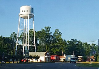
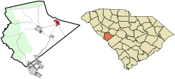
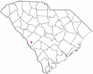
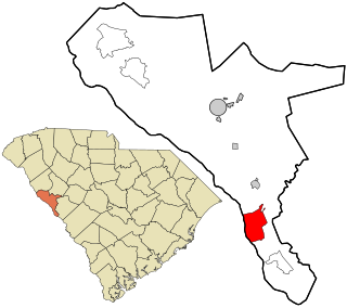
Ward is a town in Saluda County, South Carolina, United States. The population was 91 at the 2010 census.

<span class="mw-page-title-main">North Augusta, South Carolina</span> City in South Carolina, United States

North Augusta is a city in Aiken and Edgefield counties in the U.S. state of South Carolina, on the north bank of the Savannah River. It lies directly across the river, and state border, from Augusta, Georgia. The population was 24,379 at the 2020 census, making it the 21st-most populous city in South Carolina. The city is included in the Central Savannah River Area (CSRA) and is part of the Augusta, Georgia, metropolitan area.

<span class="mw-page-title-main">Augusta metropolitan area</span> Metropolitan Statistical Area in the United States

The Augusta metropolitan area, officially the Augusta-Richmond County metropolitan statistical area according to the U.S. Office of Management and Budget, Census Bureau and other agencies, is a metropolitan statistical area centered on the city of Augusta, Georgia. It straddles two U.S. states, Georgia and South Carolina, and includes the Georgia counties of Richmond, Burke, Columbia, Lincoln, and McDuffie as well as the South Carolina counties of Aiken and Edgefield. The official 2023 U.S. census estimate for the area was 629,429 residents, up from 611,000 at the 2020 U.S. census.

References

  1. "ArcGIS REST Services Directory". United States Census Bureau. Retrieved October 15, 2022.
  2. 1 2 "Census Population API". United States Census Bureau. Retrieved October 15, 2022.
  3. 1 2 "U.S. Census website". United States Census Bureau . Retrieved January 31, 2008.
  4. "US Board on Geographic Names". United States Geological Survey. October 25, 2007. Retrieved January 31, 2008.
  5. 1 2 "Geographic Identifiers: 2010 Census Summary File 1 (G001): Johnston town, South Carolina". American Factfinder. U.S. Census Bureau. Archived from the original on February 13, 2020. Retrieved March 22, 2016.
  6. "US Gazetteer files: 2010, 2000, and 1990". United States Census Bureau. February 12, 2011. Retrieved April 23, 2011.
  7. "Census of Population and Housing". Census.gov. Retrieved June 4, 2015.
  8. "2010 Census Population of Johnston, South Carolina - CensusViewer".
  9. "Explore Census Data". data.census.gov. Retrieved December 15, 2021.
  10. "Archived copy". Archived from the original on November 28, 2010. Retrieved November 3, 2010.{{cite web}}: CS1 maint: archived copy as title (link)
  11. "South Carolina libraries and archives". SCIWAY. Retrieved June 7, 2019.