Warrenton, Georgia

Last updated
Warrenton, Georgia
Warren County Courthouse, Warrenton, GA.jpg
Warren County Courthouse
Warren County Georgia Incorporated and Unincorporated areas Warrenton Highlighted.svg
Location in Warren County and the state of Georgia
Coordinates: 33°24′27″N82°39′46″W / 33.40750°N 82.66278°W / 33.40750; -82.66278 Coordinates: 33°24′27″N82°39′46″W / 33.40750°N 82.66278°W / 33.40750; -82.66278
Country United States
State Georgia
County Warren
Area
[1]
  Total1.92 sq mi (4.98 km2)
  Land1.91 sq mi (4.94 km2)
  Water0.02 sq mi (0.04 km2)
Elevation
518 ft (158 m)
Population
 (2020)
  Total1,744
  Density914.53/sq mi (353.09/km2)
Time zone UTC-5 (Eastern (EST))
  Summer (DST) UTC-4 (EDT)
ZIP code
30828
Area code 706
FIPS code 13-80592 [2]
GNIS feature ID0333368 [3]
Website www.warrentonga.gov

Warrenton is a city in Warren County, Georgia, United States. The population was 1,937 at the 2010 census. The city is the county seat of Warren County. [4]

Contents

History

Warrenton was founded in 1797 as seat of Warren County (est. 1793). It was incorporated as a town in 1810 and as a city in 1908. [5] The community was named for American Revolutionary War general Joseph Warren. [6]

On May 2, 1919 a crowd of three hundred white farmers shot to death and burned the corpse of a black farmer, Benny Richards, who was accused of murdering his own ex-wife. [7]

Geography

Warrenton is located at 33°24′27″N82°39′46″W / 33.40750°N 82.66278°W / 33.40750; -82.66278 (33.407596, -82.662914). [8]

According to the United States Census Bureau, the city has a total area of 1.9 square miles (4.9 km2), of which, 1.9 square miles (4.9 km2) of it is land and 0.52% is water.

Climate

Climate data for Warrenton, Georgia, 1991–2020 normals, extremes 19142017
MonthJanFebMarAprMayJunJulAugSepOctNovDecYear
Record high °F (°C)86
(30)
83
(28)
90
(32)
95
(35)
100
(38)
110
(43)
109
(43)
107
(42)
108
(42)
99
(37)
90
(32)
80
(27)
110
(43)
Mean maximum °F (°C)71.1
(21.7)
75.3
(24.1)
81.1
(27.3)
86.3
(30.2)
90.6
(32.6)
95.8
(35.4)
97.8
(36.6)
96.9
(36.1)
92.5
(33.6)
85.7
(29.8)
79.7
(26.5)
73.2
(22.9)
99.2
(37.3)
Average high °F (°C)56.2
(13.4)
59.4
(15.2)
67.1
(19.5)
75.0
(23.9)
82.2
(27.9)
88.0
(31.1)
91.2
(32.9)
89.5
(31.9)
84.4
(29.1)
75.3
(24.1)
65.9
(18.8)
58.1
(14.5)
74.4
(23.5)
Daily mean °F (°C)44.7
(7.1)
47.4
(8.6)
54.1
(12.3)
61.6
(16.4)
69.6
(20.9)
76.6
(24.8)
80.2
(26.8)
78.8
(26.0)
73.3
(22.9)
63.0
(17.2)
53.0
(11.7)
46.7
(8.2)
62.4
(16.9)
Average low °F (°C)33.1
(0.6)
35.4
(1.9)
41.1
(5.1)
48.3
(9.1)
57.1
(13.9)
65.3
(18.5)
69.1
(20.6)
68.2
(20.1)
62.2
(16.8)
50.7
(10.4)
40.1
(4.5)
35.3
(1.8)
50.5
(10.3)
Mean minimum °F (°C)16.4
(−8.7)
20.9
(−6.2)
25.6
(−3.6)
33.1
(0.6)
43.8
(6.6)
56.1
(13.4)
62.2
(16.8)
60.5
(15.8)
48.5
(9.2)
35.1
(1.7)
27.8
(−2.3)
19.7
(−6.8)
14.0
(−10.0)
Record low °F (°C)−3
(−19)
7
(−14)
11
(−12)
26
(−3)
37
(3)
40
(4)
53
(12)
52
(11)
36
(2)
26
(−3)
9
(−13)
5
(−15)
−3
(−19)
Average precipitation inches (mm)4.47
(114)
4.21
(107)
4.94
(125)
3.04
(77)
3.07
(78)
4.04
(103)
3.94
(100)
4.59
(117)
3.97
(101)
3.42
(87)
3.38
(86)
3.93
(100)
47
(1,195)
Average precipitation days (≥ 0.01 in)7.56.96.85.76.06.87.17.35.04.85.46.876.1
Source 1: NOAA [9]
Source 2: National Weather Service (mean maxima/minima, precip/precip days 19812010) [10]

Demographics

Historical population
CensusPop.Note
1880 1,022
1890 974−4.7%
1900 1,11314.3%
1910 1,36822.9%
1920 1,4072.9%
1930 1,289−8.4%
1940 1,284−0.4%
1950 1,44212.3%
1960 1,77022.7%
1970 2,07317.1%
1980 2,1724.8%
1990 2,056−5.3%
2000 2,013−2.1%
2010 1,937−3.8%
2020 1,744−10.0%
U.S. Decennial Census [11]

2020 census

Warrenton racial composition [12]
RaceNum.Perc.
White (non-Hispanic)40923.45%
Black or African American (non-Hispanic)1,27673.17%
Native American 20.11%
Asian 100.57%
Other/Mixed 352.01%
Hispanic or Latino 120.69%

As of the 2020 United States census, there were 1,744 people, 840 households, and 528 families residing in the city.

2000 census

As of the census [2] of 2000, there were 2,013 people, 816 households, and 527 families residing in the city. The population density was 1,056.9 inhabitants per square mile (408.1/km2). There were 909 housing units at an average density of 477.3 per square mile (184.3/km2). The racial makeup of the city was 29.41% White, 69.40% African American, 0.25% Native American, 0.15% Asian, 0.25% from other races, and 0.55% from two or more races. Hispanic or Latino of any race were 0.70% of the population.

There were 816 households, out of which 32.2% had children under the age of 18 living with them, 31.1% were married couples living together, 28.7% had a female householder with no husband present, and 35.4% were non-families. 31.4% of all households were made up of individuals, and 15.6% had someone living alone who was 65 years of age or older. The average household size was 2.45 and the average family size was 3.09.

In the city, the population was spread out, with 29.0% under the age of 18, 9.8% from 18 to 24, 24.0% from 25 to 44, 21.9% from 45 to 64, and 15.3% who were 65 years of age or older. The median age was 35 years. For every 100 females, there were 80.4 males. For every 100 females age 18 and over, there were 71.7 males.

The median income for a household in the city was $18,750, and the median income for a family was $25,898. Males had a median income of $26,818 versus $20,625 for females. The per capita income for the city was $12,778. About 30.7% of families and 36.0% of the population were below the poverty line, including 55.0% of those under age 18 and 26.9% of those age 65 or over.


Education

Warren County School District

The Warren County School District holds pre-school to grade twelve, and consists of one elementary school, a middle school, and a high school. [13] (The district has only 2 physical buildings, one for Pre-K and K, the other for 1-12.)The district has 70 full-time teachers and over 894 students. [14]

See also

Related Research Articles

<span class="mw-page-title-main">Warren County, Missouri</span> County in Missouri, United States

Warren County is a county located in the eastern portion of the U.S. state of Missouri. As of the 2010 census, the population was 32,513. The county is located on the north side of the Missouri River. Its county seat is Warrenton. The county was established on January 5, 1833, and was named for General Joseph Warren, who died in the Battle of Bunker Hill during the American Revolutionary War.

<span class="mw-page-title-main">Washington County, Georgia</span> County in Georgia, United States

Washington County is a county located in the U.S. state of Georgia. As of the 2020 census, the population was 19,988. The county seat is Sandersville. The county was established on February 25, 1784. It was named for Revolutionary War general George Washington.

<span class="mw-page-title-main">Warren County, Georgia</span> County in Georgia, United States

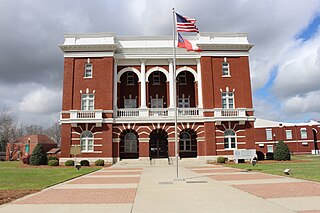
Warren County is a county located in the U.S. state of Georgia. As of the 2020 United States census, the population was 5,215, a decrease from 2010. The county seat is Warrenton. The county was created on December 19, 1793, and is named after General Joseph Warren, who was killed in the Battle of Bunker Hill.

<span class="mw-page-title-main">Tattnall County, Georgia</span> County in Georgia, United States

Tattnall County is a county located in the southeast portion of the U.S. state of Georgia. As of the 2020 census, the population was 22,842. The county seat is Reidsville. Tattnall County was created on December 5, 1801, from part of Montgomery County, Georgia by the Georgia General Assembly. The county was named after Josiah Tattnall (1762–1803), a planter, soldier and politician. It is located within the Magnolia Midlands, a part of the Historic South region.

<span class="mw-page-title-main">Alma, Georgia</span> City in Georgia, United States

Alma is a city in Bacon County, Georgia, United States, and the county seat. As of the 2020 census, the city had a population of 3,433.

<span class="mw-page-title-main">Pembroke, Georgia</span> City and County Seat in Georgia, United States

Pembroke is a city and county seat in Bryan County, Georgia, United States. As of the 2020 census, the population of the city was 2,513. It is located approximately 35 miles west of Savannah, Georgia, and approximately 20 miles south of Statesboro, Georgia.

<span class="mw-page-title-main">Gibson, Georgia</span> City in Georgia, United States

Gibson is a city in Glascock County, Georgia, United States. The population was 663 at the 2010 census. The city is the county seat of Glascock County and home to the Glascock County Courthouse, a National Register of Historic Places listed site.

<span class="mw-page-title-main">Sparta, Georgia</span> Town in Georgia, United States

Sparta is a city in and the county seat of Hancock County, Georgia, United States. It is part of the Milledgeville Micropolitan Statistical Area. The city's population was 1,400 at the 2010 census.

<span class="mw-page-title-main">Stapleton, Georgia</span> City in Georgia, United States

Stapleton is a city in Jefferson County, Georgia, United States. The population was 438 at the 2010 census, up from 318 at the 2000 census.

<span class="mw-page-title-main">Mount Vernon, Georgia</span> City in Georgia, United States

Mount Vernon is a city in, and the county seat of, Montgomery County, Georgia, United States. The population was 1,900 at the 2020 census, down from 2,451 in 2010. It is home to Brewton–Parker College.

<span class="mw-page-title-main">Georgetown, Quitman County, Georgia</span> City in Georgia, United States

Georgetown is a city in Quitman County, Georgia, United States. It is on the Alabama-Georgia state line next to Walter F. George Lake and across the Chattahoochee River from Eufaula, Alabama. Per the 2020 census, the population was 2,235. In 2006, Georgetown and Quitman County voted to consolidate their governments, becoming the smallest such consolidated entity in the Lower 48 states.

<span class="mw-page-title-main">Crawfordville, Georgia</span> Town in Georgia, United States

Crawfordville is a town in Taliaferro County, Georgia, United States. The population was 534 at the 2010 census. The city is the county seat of Taliaferro County.

<span class="mw-page-title-main">Lyons, Georgia</span> City in Georgia, United States

Lyons is a city in Toombs County, Georgia, United States. The population was 4,367 at the 2010 census, up from 4,169 in 2000. The city is the county seat of Toombs County.

<span class="mw-page-title-main">Soperton, Georgia</span> City in Georgia, United States

Soperton is a city in Treutlen County, Georgia, United States. The population was 3,115 at the 2010 census, up from 2,824 in 2000. The city is the county seat of Treutlen County.

<span class="mw-page-title-main">Camak, Georgia</span> Town in Georgia, United States

Camak is a town in Warren County, Georgia, United States. The town is located just off Interstate 20 between Atlanta and Augusta. The population was 165 at the 2000 census.

<span class="mw-page-title-main">Norwood, Georgia</span> City in Georgia, United States

Norwood is a city in Warren County, Georgia, United States. The population was 299 at the 2000 census.

<span class="mw-page-title-main">Alamo, Georgia</span> City in Georgia, United States

Alamo is a city in Wheeler County, Georgia, United States. As of the 2020 census, the city had a population of 771. The city is the county seat of Wheeler County.

<span class="mw-page-title-main">Warrenton, Missouri</span> City in Missouri, United States

Warrenton is a city in Warren County, Missouri, United States. The population was 7,880 according to the 2010 Census. It is the county seat of Warren County. Warrenton is an exurb of St. Louis, and is located in the St. Louis Metropolitan Statistical Area. Warrenton's slogan is "A City for All Seasons."

<span class="mw-page-title-main">Warrenton, Oregon</span> Unincorporated community in the state of Oregon, United States

Warrenton is a small, coastal city in Clatsop County, Oregon, United States. Named for D.K. Warren, an early settler, the town is primarily a fishing and logging community. The population was 6,277 according to the 2020 US Census. Warrenton is a less urbanized area close to the Clatsop County seat, Astoria.

Appling is a census-designated place in and the county seat of Columbia County, Georgia, United States. As of the 2020 census, its population is 658. It is part of the Augusta metropolitan area.

References

  1. "2020 U.S. Gazetteer Files". United States Census Bureau. Retrieved December 18, 2021.
  2. 1 2 "U.S. Census website". United States Census Bureau . Retrieved 2008-01-31.
  3. "US Board on Geographic Names". United States Geological Survey. 2007-10-25. Retrieved 2008-01-31.
  4. "Find a County". National Association of Counties. Retrieved 2011-06-07.
  5. Hellmann, Paul T. (May 13, 2013). Historical Gazetteer of the United States. Routledge. p. 252. ISBN   978-1135948597 . Retrieved 30 November 2013.
  6. Krakow, Kenneth K. (1975). Georgia Place-Names: Their History and Origins (PDF). Macon, GA: Winship Press. p. 247. ISBN   0-915430-00-2.
  7. Burning at Stake in the United States: A Record of the Public Burning by Mobs of Five Men, During the First Five Months of 1919. Black Classic Press. 1986. p. 13. ISBN   978-0-933121-13-3.
  8. "US Gazetteer files: 2010, 2000, and 1990". United States Census Bureau. 2011-02-12. Retrieved 2011-04-23.
  9. "U.S. Climate Normals Quick Access – Station: Warrenton, GA". National Oceanic and Atmospheric Administration. Retrieved May 11, 2023.
  10. "NOAA Online Weather Data – NWS Atlanta". National Weather Service. Retrieved May 11, 2023.
  11. "Census of Population and Housing". Census.gov. Retrieved June 4, 2015.
  12. "Explore Census Data". data.census.gov. Retrieved 2021-12-15.
  13. Georgia Board of Education, Retrieved June 29, 2010.
  14. School Stats, Retrieved June 29, 2010.