Hazlehurst, Georgia

Last updated

Hazlehurst, Georgia
Hazlehurst City Hall.JPG
Hazlehurst City Hall
Flag of Hazlehurst, Georgia.png
Seal of Hazlehurst, Georgia.png
Motto: 
"Come linger' longer"
Jeff Davis County Georgia Incorporated and Unincorporated areas Hazlehurst Highlighted.svg
Location in Jeff Davis County and the state of Georgia
Coordinates: 31°51′58″N82°35′58″W / 31.86611°N 82.59944°W / 31.86611; -82.59944
Country United States
State Georgia
County Jeff Davis
Named for George Hazlehurst
Government
  MayorJohn Ramay
Area
[1]
  Total4.81 sq mi (12.45 km2)
  Land4.73 sq mi (12.26 km2)
  Water0.08 sq mi (0.20 km2)
Elevation
249 ft (76 m)
Population
 (2020)
  Total4,088
  Density863.72/sq mi (333.48/km2)
Time zone UTC-5 (Eastern (EST))
  Summer (DST) UTC-4 (EDT)
ZIP code
31539
Area code 912
FIPS code 13-37564 [2]
GNIS feature ID0315266 [3]
Website http://www.hazlehurstga.gov

Hazlehurst is a city in and the county seat of Jeff Davis County, Georgia, United States. [4] The population was 4,088 in 2020.

Contents

History

Hazlehurst was founded circa 1880 as a depot on the Macon and Brunswick Railroad. [5] The community was named for railroad surveyor Col. George Hazlehurst. [6]

Geography

Hazlehurst is located in southeast Georgia, and is served by U.S. routes 23, 221 and 341.

Climate

Climate data for Hazlehurst, Georgia, 1991–2020 normals, extremes 19182015
MonthJanFebMarAprMayJunJulAugSepOctNovDecYear
Record high °F (°C)85
(29)
84
(29)
93
(34)
95
(35)
102
(39)
105
(41)
107
(42)
104
(40)
106
(41)
97
(36)
88
(31)
85
(29)
107
(42)
Mean daily maximum °F (°C)60.3
(15.7)
64.1
(17.8)
70.9
(21.6)
77.8
(25.4)
85.1
(29.5)
89.7
(32.1)
92.4
(33.6)
91.4
(33.0)
86.6
(30.3)
78.7
(25.9)
69.8
(21.0)
62.5
(16.9)
77.4
(25.2)
Daily mean °F (°C)49.1
(9.5)
52.4
(11.3)
58.8
(14.9)
65.5
(18.6)
73.3
(22.9)
79.2
(26.2)
82.1
(27.8)
81.2
(27.3)
76.3
(24.6)
66.9
(19.4)
57.5
(14.2)
51.4
(10.8)
66.1
(19.0)
Mean daily minimum °F (°C)37.9
(3.3)
40.7
(4.8)
46.7
(8.2)
53.2
(11.8)
61.5
(16.4)
68.8
(20.4)
71.7
(22.1)
71.0
(21.7)
66.0
(18.9)
55.2
(12.9)
45.2
(7.3)
40.3
(4.6)
54.9
(12.7)
Record low °F (°C)10
(−12)
18
(−8)
20
(−7)
29
(−2)
40
(4)
47
(8)
58
(14)
56
(13)
45
(7)
28
(−2)
19
(−7)
15
(−9)
10
(−12)
Average precipitation inches (mm)4.15
(105)
4.21
(107)
4.41
(112)
3.65
(93)
3.30
(84)
5.28
(134)
4.50
(114)
6.87
(174)
4.47
(114)
2.95
(75)
2.98
(76)
4.09
(104)
50.86
(1,292)
Average snowfall inches (cm)0.0
(0.0)
0.1
(0.25)
0.0
(0.0)
0.0
(0.0)
0.0
(0.0)
0.0
(0.0)
0.0
(0.0)
0.0
(0.0)
0.0
(0.0)
0.0
(0.0)
0.0
(0.0)
0.0
(0.0)
0.1
(0.25)
Average precipitation days (≥ 0.01 in)10.410.29.17.67.112.512.413.311.48.67.19.7119.4
Average snowy days (≥ 0.1 in)0.00.10.00.00.00.00.00.00.00.00.00.00.1
Source 1: NOAA [7]
Source 2: XMACIS2 [8]

Demographics

Historical population
CensusPop.Note
1890 290
1900 793173.4%
1910 1,18148.9%
1920 1,38317.1%
1930 1,378−0.4%
1940 1,73225.7%
1950 2,68755.1%
1960 3,69937.7%
1970 4,0659.9%
1980 4,2985.7%
1990 4,202−2.2%
2000 3,787−9.9%
2010 4,22611.6%
2020 4,088−3.3%
U.S. Decennial Census [9]
Hazlehurst racial composition as of 2020 [10]
RaceNum.Perc.
White (non-Hispanic)2,07850.83%
Black or African American (non-Hispanic)1,35933.24%
Native American 90.22%
Asian 220.54%
Pacific Islander 30.07%
Other/Mixed 1233.01%
Hispanic or Latino 49412.08%

As of the 2020 United States census, there were 4,088 people, 1,494 households, and 894 families residing in the city.

Education

Jeff Davis County School District

The Jeff Davis County School District consists of two elementary schools, a middle school, and a high school. [11] The district has 210 classroom teachers and 3,075 students. [12]

Related Research Articles

<span class="mw-page-title-main">Jeff Davis County, Georgia</span> County in Georgia, United States

Jeff Davis County is a county located in the southeastern part of the U.S. state of Georgia. As of the 2020 census, the population was 14,779. The county seat is Hazlehurst. The county was created on August 18, 1905, and named for Jefferson Davis, the only Confederate president.

<span class="mw-page-title-main">Surrency, Georgia</span> Town in Georgia, United States

Surrency is a town in Appling County, Georgia, United States. The population was 194 in 2020.

<span class="mw-page-title-main">Alma, Georgia</span> City in Georgia, United States

Alma is a city in Bacon County, Georgia, United States, and the county seat. As of the 2020 census, the city had a population of 3,433.

<span class="mw-page-title-main">Fitzgerald, Georgia</span> City in Georgia, United States

Fitzgerald is a city in and the county seat of Ben Hill County in the south central portion of the U.S. state of Georgia. As of 2020, its population was 9,006. It is the principal city of the Fitzgerald micropolitan statistical area, which includes all of Ben Hill and Irwin counties.

<span class="mw-page-title-main">Nahunta, Georgia</span> City in Georgia, United States

Nahunta is a city and the county seat in Brantley County, Georgia, United States. It is part of the Brunswick, Georgia metropolitan statistical area. The population was 1,013 at the 2020 census. The city is an important crossroad which is intersected by U.S. Route 82 and U.S. Route 301 in its downtown area.

<span class="mw-page-title-main">Metter, Georgia</span> City in Georgia, United States

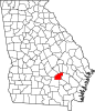
Metter is a city and the county seat of Candler County, Georgia, United States. The population was 4,130 at the 2010 census. In 2020, its population was 4,004.

<span class="mw-page-title-main">Douglas, Georgia</span> City in Georgia, United States

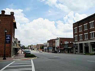
Douglas is a city in Coffee County, Georgia, United States. As of the 2020 census, the city had a population of 11,722. Douglas is the county seat of Coffee County and the core city of the Douglas micropolitan statistical area, which had a population of 50,731 as of the 2010 census.

<span class="mw-page-title-main">Grovetown, Georgia</span> City in Georgia, United States

Grovetown is a city in Columbia County, Georgia, United States. It is part of the Augusta metropolitan area and the Central Savannah River Area. The 2019 population estimate was 15,152. The mayor is Gary Jones.

<span class="mw-page-title-main">Hartwell, Georgia</span> City in Georgia, United States

Hartwell is a city in Hart County, Georgia, United States. The population was 4,469 at the 2010 census. The city is the county seat of Hart County.

<span class="mw-page-title-main">Monticello, Georgia</span> City in Georgia, United States

Monticello is the largest city in and the county seat of Jasper County, Georgia, United States. The city includes historic buildings such as the Jasper County Courthouse, Monticello High School and the Monticello Historic District. The population was 2,657 at the 2010 census. It is 56 miles (90 km) southeast of Atlanta.

<span class="mw-page-title-main">Gray, Georgia</span> City in Georgia, United States

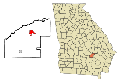
Gray is a city in Jones County, Georgia, United States. The population was 3,276 at the 2010 census, up from 1,811 at the 2000 census. In 2020, its population was 3,436. The city is the county seat of Jones County. It is part of the Macon metropolitan area.

<span class="mw-page-title-main">Mount Vernon, Georgia</span> City in Georgia, United States

Mount Vernon is a city in, and the county seat of, Montgomery County, Georgia, United States. The population was 1,900 at the 2020 census, down from 2,451 in 2010. It is home to Brewton–Parker College.

<span class="mw-page-title-main">Lexington, Georgia</span> City in Georgia, United States

The city of Lexington is the county seat of Oglethorpe County, Georgia, United States. The population was 239 at the 2000 census.

<span class="mw-page-title-main">Hawkinsville, Georgia</span> City in Georgia, United States

Hawkinsville is a city in and the county seat of Pulaski County, Georgia, United States. The population was 3,980 in 2020.

<span class="mw-page-title-main">Cuthbert, Georgia</span> City in Georgia, United States

Cuthbert is a city in, and the county seat of, Randolph County, Georgia, United States. The population was 3,520 in 2019.

<span class="mw-page-title-main">Butler, Georgia</span> City in Georgia, United States

Butler is the county seat of Taylor County, Georgia, United States. Its population was 1,972 at the 2010 census, and 1,881 in 2020.

<span class="mw-page-title-main">Soperton, Georgia</span> City in Georgia, United States

Soperton is a city in Treutlen County, Georgia, United States. The population was 2,889 in 2020. The city is the county seat of Treutlen County.

<span class="mw-page-title-main">Warrenton, Georgia</span> City in Georgia, United States

Warrenton is a city in Warren County, Georgia, United States. The population was 1,744 in 2020. The city is the county seat of Warren County.

<span class="mw-page-title-main">Sandersville, Georgia</span> City in Georgia, United States

The city of Sandersville is the county seat of Washington County, Georgia, United States. The population was 5,813 in 2020. It is also a part of the Central Savannah River Area. Sandersville is known as the "Kaolin Capital of the World" due to its abundance of kaolin.

<span class="mw-page-title-main">Jesup, Georgia</span> City in Georgia, United States

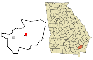
Jesup is a city in Wayne County, Georgia, United States. The population was 9,809 at the 2020 census. The city is the county seat of Wayne County.

References

  1. "2020 U.S. Gazetteer Files". United States Census Bureau. Retrieved December 18, 2021.
  2. "U.S. Census website". United States Census Bureau . Retrieved January 31, 2008.
  3. "US Board on Geographic Names". United States Geological Survey. October 25, 2007. Retrieved January 31, 2008.
  4. "Find a County". National Association of Counties. Retrieved June 7, 2011.
  5. Hellmann, Paul T. (May 13, 2013). Historical Gazetteer of the United States. Routledge. p. 233. ISBN   978-1135948597 . Retrieved November 30, 2013.
  6. Krakow, Kenneth K. (1975). Georgia Place-Names: Their History and Origins (PDF). Macon, GA: Winship Press. p. 106. ISBN   0-915430-00-2.
  7. "U.S. Climate Normals Quick Access – Station: Hazlehurst, GA". National Oceanic and Atmospheric Administration. Retrieved February 27, 2023.
  8. "xmACIS2". National Oceanic and Atmospheric Administration. Retrieved February 27, 2023.
  9. "Census of Population and Housing". Census.gov. Retrieved June 4, 2015.
  10. "Explore Census Data". data.census.gov. Retrieved December 18, 2021.
  11. Georgia Board of Education [ permanent dead link ], Retrieved June 20, 2010.
  12. National Center for Educational Statistics, Retrieved April 1, 2024