Butler, Georgia

Last updated

Butler, Georgia
Butler Municipal Building.JPG
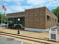
Butler Municipal Building (aka City Hall)
Taylor County Georgia Incorporated and Unincorporated areas Butler Highlighted.svg
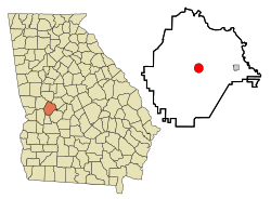
Location in Taylor County and the state of Georgia
Coordinates: 32°33′N84°14′W / 32.550°N 84.233°W / 32.550; -84.233
Country United States
State Georgia
County Taylor
Area
[1]
  Total3.26 sq mi (8.45 km2)
  Land3.25 sq mi (8.41 km2)
  Water0.02 sq mi (0.04 km2)
Elevation
628 ft (191 m)
Population
 (2020)
  Total1,881
  Density579.48/sq mi (223.73/km2)
Time zone UTC-5 (Eastern (EST))
  Summer (DST) UTC-4 (EDT)
ZIP code
31006
Area code 478
FIPS code 13-12120 [2]
GNIS feature ID0312093 [3]
Website www.cityofbutlerga.com

Butler is the county seat of Taylor County, Georgia, United States. [4] Its population was 1,972 at the 2010 census, [5] and 1,881 in 2020.

Contents

History

The Central of Georgia Railway was built through the present area of Butler about 1850. [6] The line is currently owned by Norfolk Southern and hosts three to four trains per day.

Butler was incorporated on February 8, 1854, but the charter was not received until 1870. Taylor County was carved from the Creek Indian territory which had in earlier years become the counties of Marion, Talbot, and Macon.

The chosen location of Butler was known as the "Fifty Mile Station" on the railroad because it was the geographical center of the railroad between Macon and Columbus, Georgia. Each town is approximately 50 miles (80 km) in either direction of Butler.

The city of Butler, Georgia, was named for General William Orlando Butler, a distinguished soldier of the Mexican–American War and a candidate for Vice President on the ticket with General Lewis Cass of Michigan. [7]

In late 2016, a 1070 acre 103 megawatt solar panel facility was completed. The Butler Solar Facility is owned by First Solar. [8]

Geography

Butler is located at 32°33′N84°14′W / 32.550°N 84.233°W / 32.550; -84.233 (32.557, -84.239). [9]

The city is located along U.S. Route 19, which is the main route through the city. U.S. 19 leads north 28 mi (45 km) to Thomaston and south 24 mi (39 km) to Ellaville. The Fall Line Freeway (GA-540) runs from west to east through the southern part of the city, concurrent with Georgia State Route 96. GA-540 and GA-96 lead east 9 mi (14 km) to Reynolds and west 14 mi (23 km) to Junction City. Georgia State Route 137 also runs through the city, leading northeast 20 mi (32 km) to Roberta and southwest 25 mi (40 km) to Buena Vista.

According to the United States Census Bureau, the city has a total area of 3.2 square miles (8.3 km2), of which 3.2 square miles (8.3 km2) is land and 0.31% is water.

Demographics

Historical population
CensusPop.Note
1890 712
1900 707−0.7%
1910 705−0.3%
1920 7587.5%
1930 85713.1%
1940 1,09327.5%
1950 1,1828.1%
1960 1,34613.9%
1970 1,58918.1%
1980 1,95923.3%
1990 1,673−14.6%
2000 1,90714.0%
2010 1,9723.4%
2020 1,881−4.6%
U.S. Decennial Census [10]
Butler racial composition as of 2020 [11]
RaceNum.Perc.
White (non-Hispanic)81043.06%
Black or African American (non-Hispanic)98652.42%
Native American 60.32%
Asian 40.21%
Pacific Islander 10.05%
Other/mixed 502.66%
Hispanic or Latino 241.28%

As of the 2020 United States census, there were 1,881 people, 762 households, and 447 families residing in the city.

Education

Taylor County School District

The Taylor County School District holds pre-school to grade twelve, and consists of two elementary schools, a middle school, and a high school. [12] The district has 101 full-time teachers and over 1,735 students. [13]

The Taylor County Girls' basketball team (1967–1972) holds the record for the nation's longest girl's high school basketball winning streak by winning 132 consecutive games, going undefeated for five years and winning five back-to-back state championships.[ citation needed ]

Notable people

Related Research Articles

<span class="mw-page-title-main">Webster County, Georgia</span> County in Georgia, United States

Webster County is a county located in the west central portion of the U.S. state of Georgia. As of the 2020 census reflected a population of 2,348, making it the third-least populous county in Georgia. The county seat is Preston.

<span class="mw-page-title-main">Taylor County, Georgia</span> County in Georgia, United States

Taylor County is a county located in the west central portion of the U.S. state of Georgia. As of the 2020 census, the population was 7,816. The county seat and largest city is Butler.

<span class="mw-page-title-main">Schley County, Georgia</span> County in Georgia, United States

Schley County is a county located in the west-central portion of the U.S. state of Georgia. As of the 2020 U.S. census, its population was 4,547. The county seat is Ellaville.

<span class="mw-page-title-main">Peach County, Georgia</span> County in Georgia, United States

Peach County is a county located in the central portion of the U.S. state of Georgia. As of the 2020 census, the population was 27,981. Its county seat is Fort Valley. Founded in 1924, it is the state's newest county, taken from Houston and Macon counties on July 18 of that year. Its namesake is the peach on account of it being located in a peach-growing district.

<span class="mw-page-title-main">Cusseta, Georgia</span> Consolidated city-county in Georgia, United States

Cusseta is a city in Chattahoochee County, Georgia, United States. It is part of the Columbus, Georgia-Alabama metropolitan statistical area. The population was 9,565 in 2020. The city is the county seat of Chattahoochee County, with which it shares a consolidated city-county government. Despite this, Cusseta is not coterminous with the county; it remains a geographically distinct municipality within the county.

<span class="mw-page-title-main">Roberta, Georgia</span> City in Georgia, United States

Roberta is a city in Crawford County, Georgia, United States. The population was 1,007 at the 2010 census. It is part of the Macon metropolitan statistical area.

<span class="mw-page-title-main">Blakely, Georgia</span> City in Georgia, United States

Blakely is a city and the county seat of Early County, Georgia, United States. As of 2020, its population was 5,371. It is located approximately halfway between Columbus and Tallahassee, Florida on U.S. Route 27.

<span class="mw-page-title-main">Waverly Hall, Georgia</span> Town in Georgia, United States

Waverly Hall is a town in Harris County, Georgia, United States. It is part of the Columbus, Georgia-Alabama metropolitan statistical area. The population was 638 in 2020.

<span class="mw-page-title-main">Barnesville, Georgia</span> City in Georgia, United States

Barnesville is a city in Lamar County, Georgia, United States. As of the 2010 census, the city had a population of 6,755, up from 5,972 at the 2000 census. The city is the county seat of Lamar County and is part of the Atlanta metropolitan area.

<span class="mw-page-title-main">Smithville, Georgia</span> City in Georgia, United States

Smithville is a city in Lee County, Georgia, United States. The population was 593 in 2020. It is part of the Albany, Georgia metropolitan statistical area.

<span class="mw-page-title-main">Oglethorpe, Georgia</span> City in Georgia, United States

Oglethorpe is a city in Macon County, Georgia, United States. The population was 995 at the 2020 census, down from 1,328 in 2010. The city is the county seat of Macon County. It was named for Georgia's founder, James Oglethorpe.

<span class="mw-page-title-main">Culloden, Georgia</span> City in Georgia, United States

Culloden is a city in Monroe County, Georgia, United States. The population was 200 in the 2020 census. It is part of the Macon metropolitan statistical area.

<span class="mw-page-title-main">Hawkinsville, Georgia</span> City in Georgia, United States

Hawkinsville is a city in and the county seat of Pulaski County, Georgia, United States. The population was 3,980 in 2020.

<span class="mw-page-title-main">Geneva, Georgia</span> Town in Georgia, United States

Geneva is a town in Talbot County, Georgia, United States. The population was 75 at the 2020 census.

<span class="mw-page-title-main">Junction City, Georgia</span> Town in Georgia, United States

Junction City is a town in Talbot County, Georgia, United States. The population was 138 at the 2020 census.

<span class="mw-page-title-main">Talbotton, Georgia</span> City in Georgia, United States

Talbotton is a city in Talbot County, Georgia, United States. The population was 970 at the 2010 census. The city is the county seat of Talbot County.

<span class="mw-page-title-main">Reynolds, Georgia</span> Town in Georgia, United States

Reynolds is a town in Taylor County, Georgia, United States. The population was 926 in 2020.

<span class="mw-page-title-main">Lyons, Georgia</span> City in Georgia, United States

Lyons is a city in Toombs County, Georgia, United States. The population was 4,239 in 2020. The city is the county seat of Toombs County.

<span class="mw-page-title-main">Jeffersonville, Georgia</span> City in Georgia, United States

The city of Jeffersonville is the largest city and county seat of Twiggs County, Georgia, United States. The population was 1,035 at the 2010 census, down from 1,209 in 2000.

<span class="mw-page-title-main">Thomaston, Georgia</span> City in Georgia, United States

Thomaston is a city in and the county seat of Upson County, Georgia, United States. The population was 9,170 at the 2010 census. It is the principal city of and is included in the Thomaston, Georgia Micropolitan Statistical Area, which is included in the Atlanta - Sandy Springs (GA) - Gainesville (GA) - Alabama (partial) CSA.

References

  1. "2020 U.S. Gazetteer Files". United States Census Bureau. Retrieved December 18, 2021.
  2. "U.S. Census website". United States Census Bureau . Retrieved January 31, 2008.
  3. "US Board on Geographic Names". United States Geological Survey. October 25, 2007. Retrieved January 31, 2008.
  4. "Find a County". National Association of Counties. Archived from the original on May 31, 2011. Retrieved June 7, 2011.
  5. "U.S. Census website". United States Census Bureau . Retrieved June 13, 2016.
  6. Hellmann, Paul T. (May 13, 2013). Historical Gazetteer of the United States. Routledge. p. 221. ISBN   978-1135948597 . Retrieved November 30, 2013.
  7. Krakow, Kenneth K. (1975). Georgia Place-Names: Their History and Origins (PDF). Macon, GA: Winship Press. p. 29. ISBN   0-915430-00-2.
  8. "Largest Solar Plant in Southeast Will be Built in Georgia". February 22, 2018.
  9. "US Gazetteer files: 2010, 2000, and 1990". United States Census Bureau. February 12, 2011. Retrieved April 23, 2011.
  10. "Census of Population and Housing". Census.gov. Retrieved June 4, 2015.
  11. "Explore Census Data". data.census.gov. Retrieved December 18, 2021.
  12. Georgia Board of Education [ permanent dead link ], Retrieved June 27, 2010.
  13. School Stats, Retrieved June 27, 2010.
  14. Taylor County Government Complex
  15. Taylor County Sheriff's Office