Homerville, Georgia

Last updated

Homerville, Georgia
HomervilleCityHall.jpg
Homerville City Hall
Clinch County Georgia Incorporated and Unincorporated areas Homerville Highlighted.svg
Location in Clinch County and the state of Georgia
Coordinates: 31°2′13″N82°45′5″W / 31.03694°N 82.75139°W / 31.03694; -82.75139
Country United States
State Georgia
County Clinch
Area
[1]
  Total3.51 sq mi (9.09 km2)
  Land3.49 sq mi (9.05 km2)
  Water0.02 sq mi (0.04 km2)
Elevation
177 ft (54 m)
Population
 (2020)
  Total2,344
  Density671.06/sq mi (259.10/km2)
Time zone UTC-5 (Eastern (EST))
  Summer (DST) UTC-4 (EDT)
ZIP code
31634
Area code 912
FIPS code 13-39748 [2]
GNIS feature ID0356319 [3]
Website www.cityofhomerville.com

Homerville is a city and the county seat of Clinch County, Georgia, United States. Its population was 2,456 at the 2010 census, [4] a decrease of 12.38% from 2,803 in 2000. [5] It was incorporated February 15, 1869.

Contents

History

Clinch County was created on February 14, 1850, by an act of the Georgia General Assembly, and was named for General Duncan Lamont Clinch, a decorated United States brigadier general and Georgia congressman who had recently died. Clinch, Georgia's 95th county, was formed from land originally inhabited by the Oconee people and consolidated portions of Ware County and Lowndes County. The act creating the county named Elijah Mattox, Simon W. Nichol, Timothy Kirkland, Benjamin Sirmans, and John J. Johnson as commissioners charged with selecting a county seat and constructing a courthouse.

The designated commissioners quickly settled on a site just southwest of the present-day Homerville, and in memory of President James K. Polk decided to name the county seat "Polk". Two years later, however, the Georgia General Assembly inexplicably changed the name of the county seat to "Magnolia", just as the county's first courthouse was completed. The first courthouse was quite small and was destroyed in 1856 when a citizen, presumably dissatisfied with legal proceedings brought against him, decided to destroy the courthouse by fire.

In February 1853, Dr. John Homer Mattox and his family moved from their former home on the Suwannee River and settled on a tract of land adjacent to the Magnolia stage route. In recognition of his family name, he called the settlement Homersville. Shortly thereafter the Atlantic and Gulf Railroad expansion replaced the stage route, and Mattox's settlement was simply known as "Station No.11".

Over time the settlement grew, and in 1860 approximately 275 citizens of Clinch County petitioned the Georgia General Assembly to move the county seat from the nearby Magnolia to Mattox's settlement. Later the same year, the legislature relented and officially named Station No. 11 the county seat of Clinch County. By 1863, the town of Homersville was known as Forest. It would take approximately nine more years for the legislature to officially recognize the name Homerville and incorporate the city; however, Homerville shows up as the name of the county seat in newspapers by March 1864.

Dr. John Homer Mattox's original dwelling is now the home of the Clinch County Chamber of Commerce and Welcome Center. The home recently underwent an extensive restoration that not only restored many of the rooms to their former glory but also added modern plumbing and central heat and air for the convenience of visitors. The structure now holds the administrative offices of the chamber and a museum dedicated to the early days of Clinch County.

Geography

Homerville is located in north-central Clinch County at 31°2′13″N82°45′5″W / 31.03694°N 82.75139°W / 31.03694; -82.75139 (31.036832, -82.751302). [6] U.S. Routes 84 and 441 cross in the center of town. US 84 leads east 27 miles (43 km) to Waycross and west 35 miles (56 km) to Valdosta, while US 441 leads north 35 miles (56 km) to Douglas, Georgia, and south 67 miles (108 km) to Lake City, Florida.

According to the United States Census Bureau, the city has a total area of 3.5 square miles (9.1 km2), of which 0.02 square miles (0.04 km2), or 0.50%, is water. [4] Wooded areas and swampy marshes surround the city.

Climate data for Homerville, Georgia
MonthJanFebMarAprMayJunJulAugSepOctNovDecYear
Record high °F (°C)82
(28)
84
(29)
88
(31)
91
(33)
99
(37)
104
(40)
101
(38)
100
(38)
98
(37)
94
(34)
85
(29)
80
(27)
104
(40)
Mean daily maximum °F (°C)61.4
(16.3)
65.4
(18.6)
71.8
(22.1)
78.8
(26.0)
85.8
(29.9)
90.4
(32.4)
92.3
(33.5)
91
(33)
86.9
(30.5)
79.2
(26.2)
71.2
(21.8)
63.3
(17.4)
92.3
(33.5)
Daily mean °F (°C)48.8
(9.3)
52.3
(11.3)
58.2
(14.6)
64.5
(18.1)
72
(22)
78.2
(25.7)
80.6
(27.0)
80
(27)
76
(24)
66.8
(19.3)
58.1
(14.5)
50.7
(10.4)
65.6
(18.7)
Mean daily minimum °F (°C)36.2
(2.3)
39.2
(4.0)
44.7
(7.1)
50.3
(10.2)
58.2
(14.6)
66.1
(18.9)
68.8
(20.4)
69
(21)
65.1
(18.4)
54.4
(12.4)
45.1
(7.3)
38.2
(3.4)
36.2
(2.3)
Record low °F (°C)21
(−6)
18
(−8)
25
(−4)
39
(4)
47
(8)
55
(13)
66
(19)
64
(18)
56
(13)
34
(1)
23
(−5)
22
(−6)
18
(−8)
Average precipitation inches (mm)4.7
(120)
4
(100)
4.6
(120)
2.9
(74)
2.6
(66)
6
(150)
6.3
(160)
6.1
(150)
4.4
(110)
2.9
(74)
2.7
(69)
3.3
(84)
50.3
(1,280)
Average snowfall inches (cm)0
(0)
0
(0)
0
(0)
0
(0)
0
(0)
0
(0)
0
(0)
0
(0)
0
(0)
0
(0)
0
(0)
0.1
(0.25)
0.1
(0.25)
Average precipitation days9.99.18.867.112.913.912.49.56.86.88.3111.5
Source: Weatherbase [7]

Demographics

Historical population
CensusPop.Note
1880 201
1900 434
1910 4370.7%
1920 62743.5%
1930 1,15083.4%
1940 1,52232.3%
1950 1,78717.4%
1960 2,63447.4%
1970 3,02514.8%
1980 3,1122.9%
1990 2,560−17.7%
2000 2,8039.5%
2010 2,456−12.4%
2020 2,344−4.6%
U.S. Decennial Census [8]
Homerville racial composition as of 2020 [9]
RaceNum.Perc.
White (non-Hispanic)1,06745.52%
Black or African American (non-Hispanic)1,08646.33%
Native American 110.47%
Asian 170.73%
Pacific Islander 40.17%
Other/Mixed 813.46%
Hispanic or Latino 783.33%

As of the 2020 United States census, there were 2,344 people, 983 households, and 610 families residing in the city.

Education

Clinch County School District

The Clinch County School District holds pre-school to grade twelve, and consists of a headstart, elementary/middle school, and a high school.

The district has 96 full-time teachers and over 1,499 students. [10]

Related Research Articles

<span class="mw-page-title-main">Jackson County, Georgia</span> County in Georgia, United States

Jackson County is a county located in the northeastern part of the U.S. state of Georgia. As of the 2020 census, the population was 75,907. The county seat is Jefferson.

<span class="mw-page-title-main">Emanuel County, Georgia</span> County in Georgia, United States

Emanuel County is a county located in the magnolia midlands portion of the U.S. state of Georgia. As of the 2020 census, the population was 22,768. The county seat is Swainsboro.

<span class="mw-page-title-main">Clinch County, Georgia</span> County in Georgia, United States

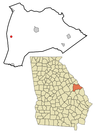
Clinch County is a county located in the southeastern part of the U.S. state of Georgia. As of the 2020 census, the population was 6,749. The county seat is Homerville. The county was created on February 14, 1850, named in honor of Duncan Lamont Clinch.

<span class="mw-page-title-main">Alma, Georgia</span> City in Georgia, United States

Alma is a city in Bacon County, Georgia, United States, and the county seat. As of the 2020 census, the city had a population of 3,433.

<span class="mw-page-title-main">Vidette, Georgia</span> City in Georgia, United States

Vidette is a city in Burke County, Georgia, United States. The population was 103 in 2020. It is part of the Augusta, Georgia metropolitan area.

<span class="mw-page-title-main">Du Pont, Georgia</span> Town in Georgia, United States

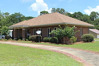
Du Pont is a town in Clinch County, Georgia, United States. The population was 134 in 2020.

<span class="mw-page-title-main">Fargo, Georgia</span> City in Georgia, United States

Fargo is a city in Clinch County, Georgia, United States. As of the 2020 census, the city had a population of 250. Formerly a town, it was incorporated by the Georgia state legislature in 1992, effective on April 1 of that year.

<span class="mw-page-title-main">Eastman, Georgia</span> City in Georgia, United States

Eastman is a city in Dodge County, Georgia, United States. The population was 5,658 at the 2020 census, up from 4,962 at the 2010 census. The city was named after William Pitt Eastman, a native of Massachusetts who purchased a large tract of land along the Macon and Brunswick Railroad, and settled a city on the site.

<span class="mw-page-title-main">Gibson, Georgia</span> City in Georgia, United States

Gibson is a city in Glascock County, Georgia, United States. The population was 663 at the 2010 census, and 630 in 2020. The city is the county seat of Glascock County and home to the Glascock County Courthouse, a National Register of Historic Places listed site.

<span class="mw-page-title-main">Hartwell, Georgia</span> City in Georgia, United States

Hartwell is a city in Hart County, Georgia, United States. The population was 4,469 at the 2010 census. The city is the county seat of Hart County.

<span class="mw-page-title-main">Wrightsville, Georgia</span> City in Georgia, United States

Wrightsville is a city in and the county seat of Johnson County, Georgia, United States. The population was 2,195 at the 2010 census, down from 2,223 at the 2000 census. By 2020, its population grew to 3,449. The city limits include Johnson State Prison on the northeast side of town. Wrightsville is part of the Dublin Micropolitan Statistical Area.

<span class="mw-page-title-main">Hinesville, Georgia</span> City in Georgia, United States

Hinesville is a city and county seat of Liberty County, Georgia, United States, located on the Atlantic coastal plain. The population was 33,437 at the 2010 census and an estimated 33,273 in 2019. By 2020, its population was 34,891. It is the principal city of the Hinesville metropolitan area, which comprises all of Liberty County, including the Fort Stewart army installation, plus neighboring Long County.

<span class="mw-page-title-main">Lincolnton, Georgia</span> City in Georgia, United States

Lincolnton is a city and the county seat of Lincoln County, Georgia, United States. The population was 1,480 at the 2020 census. It contains numerous houses and historic districts listed on the National Register of Historic Places. Both the city and the county were named for General Benjamin Lincoln, who served in the Continental Army during the American Revolution.

<span class="mw-page-title-main">Greenville, Georgia</span> City in Georgia, United States

Greenville is a city and the county seat of Meriwether County, Georgia, United States. The population was 794 at the 2020 census, down from 876 in 2010. The city is located 60 miles (97 km) southwest of Atlanta and is part of the Atlanta metropolitan area.

<span class="mw-page-title-main">Georgetown, Quitman County, Georgia</span> City in Georgia, United States

Georgetown is a city in Quitman County, Georgia, United States. It is on the Alabama-Georgia state line next to Walter F. George Lake and across the Chattahoochee River from Eufaula, Alabama. Per the 2020 census, the population was 2,235. In 2006, Georgetown and Quitman County voted to consolidate their governments, becoming the smallest such consolidated entity in the Lower 48 states.

<span class="mw-page-title-main">Tifton, Georgia</span> City in Georgia, United States

Tifton is a city in and the county seat of Tift County, Georgia, United States. The population was 17,045 at the 2020 census.

<span class="mw-page-title-main">Washington, Georgia</span> City in Georgia, United States

Washington is the county seat of Wilkes County, Georgia, United States. Under its original name, Heard's Fort, it was for a brief time during the American Revolutionary War the Georgia state capital. It is noteworthy as the place where the Confederacy voted to dissolve itself, effectively ending the American Civil War.

<span class="mw-page-title-main">Waynesboro, Georgia</span> City in Georgia, United States

Waynesboro is a city and the county seat of Burke County, Georgia, United States. The population was 5,766 at the 2010 census. It is part of the Augusta, Georgia metropolitan area.

Magnolia is an unincorporated community in Clinch County, in the U.S. state of Georgia.

Cogdell is an unincorporated community and census-designated place (CDP) in the northeast corner of Clinch County, Georgia, United States. It is on Georgia State Route 122, 22 miles (35 km) west of Waycross and 24 miles (39 km) east of Lakeland. Homerville, the Clinch county seat, is 10 miles (16 km) to the south.

References

  1. "2020 U.S. Gazetteer Files". United States Census Bureau. Retrieved December 18, 2021.
  2. "U.S. Census website". United States Census Bureau . Retrieved January 31, 2008.
  3. "US Board on Geographic Names". United States Geological Survey. October 25, 2007. Retrieved January 31, 2008.
  4. 1 2 "Geographic Identifiers: 2010 Demographic Profile Data (G001): Homerville city, Georgia". U.S. Census Bureau, American Factfinder. Archived from the original on February 12, 2020. Retrieved July 29, 2014.
  5. "Find a County". National Association of Counties. Archived from the original on May 31, 2011. Retrieved June 7, 2011.
  6. "US Gazetteer files: 2010, 2000, and 1990". United States Census Bureau. February 12, 2011. Retrieved April 23, 2011.
  7. "Historical Weather for Homerville, Georgia, United States". Weatherbase. Retrieved July 27, 2010.
  8. "Census of Population and Housing". Census.gov. Retrieved June 4, 2015.
  9. "Explore Census Data". data.census.gov. Retrieved December 17, 2021.
  10. School Stats, Retrieved June 4, 2010.