Milledgeville, Georgia

Last updated

Milledgeville, Georgia
City of Milledgeville
Old Governor's Mansion; Milledgeville, Georgia; March 13, 2011.JPG
Flag of Milledgeville, Georgia.png
Seal of Milledgeville, Georgia.png
Motto(s): 
"Capitols, Columns and Culture"
Baldwin County Georgia Incorporated and Unincorporated areas Milledgeville Highlighted.svg
Location in Baldwin County and the state of Georgia
Usa edcp relief location map.png
Red pog.svg
Milledgeville
Location of Milledgeville in the US
Coordinates: 33°5′16″N83°14′0″W / 33.08778°N 83.23333°W / 33.08778; -83.23333
Country Flag of the United States.svg  United States
State Flag of Georgia (U.S. state).svg Georgia
County Baldwin
Incorporated December 12, 1804;219 years ago (1804-12-12)
Named for John Milledge
Government
[1]
  Type Council–Manager
   Mayor Mary Parham-Copelan
   Manager Barry Jarrett
   Council
Members
  • Dr. Collinda Lee
  • Jeanette Walden
  • Denese Shinholster – Council President Pro-Tem
  • Walter Reynolds
  • Richard Mullins, Jr.
  • Stephen Chambers
Area
[2]
  Total20.48 sq mi (53.05 km2)
  Land20.32 sq mi (52.63 km2)
  Water0.16 sq mi (0.42 km2)
Elevation
330 ft (100 m)
Population
 (2020)
  Total17,070
  Density839.98/sq mi (324.31/km2)
Time zone UTC-5 (Eastern Time)
  Summer (DST) UTC-4 (EDT)
ZIP code(s)
31061
Area code(s) 478
FIPS code 13-51492 [3]
GNIS feature ID0332390 [4]
Website milledgevillega.us

Milledgeville is a city in and the county seat of Baldwin County in the U.S. state of Georgia. [5] It is northeast of Macon and bordered on the east by the Oconee River. The rapid current of the river here made this an attractive location to build a city. It was the capital of Georgia from 1804 to 1868, including during the American Civil War. Milledgeville was preceded as the capital city by Louisville and was succeeded by Atlanta, the current capital. Today U.S. Highway 441 connects Milledgeville to Madison, Athens, and Dublin.

Contents

As of April 1, 2020, the population of Milledgeville was 17,070, down from 17,715 at the 2010 U.S. census. [6]

Milledgeville is along the route of the Fall Line Freeway, which is under construction to link Milledgeville with Augusta, Macon, Columbus, and other Fall Line cities. They have long histories from the colonial era of Georgia.

Milledgeville is the principal city of the Milledgeville micropolitan statistical area, a micropolitan area that includes Baldwin and Hancock counties. [7] It had a combined population of 52,534 at the 2020 census. [3] The Old State Capitol is located here; it was added to the National Register of Historic Places (NRHP). Much of the original city is contained within the boundaries of the Milledgeville Historic District, which was also added to the NRHP.

History

Milledgeville, named after Georgia governor John Milledge (in office 1802–1806), was founded by European Americans at the start of the 19th century as the new centrally located capital of the state of Georgia. It served as the state capital from 1804 to 1868.

In 1803 an act of the Georgia legislature called for the establishment and survey of a town to be named in honor of the current governor, John Milledge. The Treaty of Fort Wilkinson (1802) had recently forced Native American tribes to cede territory immediately west of the Oconee River. The white population of Georgia continued to press west and south in search of new farmland. The town of Milledgeville was developed in an area that had long been occupied by indigenous peoples.

In December 1804 the state legislature declared Milledgeville the new capital of Georgia. The new planned town, modeled after Savannah and Washington, D.C., stood on the edge of the frontier at the Atlantic fall line, where the Upper Coastal Plain meets the foothills and plateau of the Piedmont. The area was surveyed, and a town plat of 500 acres (2.0 km2) was divided into 84 4-acre (16,000 m2) squares. The survey also included four public squares of 20 acres (81,000 m2) each.

Life in the antebellum capital

Georgia's second capitol building, built 1807-1837 (1937 photo, HABS) Old Georgia State Capitol.jpg
Georgia's second capitol building, built 1807-1837 (1937 photo, HABS)

After 1815 Milledgeville became increasingly prosperous and more respectable. Wealth and power gravitated toward the capital. Much of the surrounding countryside was developed by slave labor for cotton plantations, which was the major commodity crop of the South. Cotton bales regularly were set up to line the roads, waiting to be shipped downriver to Darien.

Public-spirited citizens such as Tomlinson Fort (mayor of Milledgeville, 1847–1848) promoted better newspapers, learning academies, and banks. In 1837-1842 the Georgia Lunatic Asylum (later the Central State Hospital) was built here. Oglethorpe University, where the poet Sidney Lanier was later educated, opened its doors in 1838. (The college, forced to close in 1862 during the war, was rechartered in 1913. It moved its campus to Atlanta.)

The cotton boom in this upland area significantly increased the demand for slave labor. The town market, where slave auctions took place, was located on Capital Square, next to the Presbyterian church. Skilled black carpenters, masons, and laborers were forced to construct most of the handsome antebellum structures in Milledgeville. [8]

Two events epitomized Milledgeville's status as the political and social center of Georgia in this period:

By 1854 Baldwin County had a total population of 8,148, of whom 3,566 were free (mostly white), and 4,602 were African American slaves.

American Civil War and its aftermath

Burning of the penitentiary at Milledgeville. Confederates used the penitentiary as an armory. Burning of the penitentiary at Milledgeville, GA - November 23 1864.jpg
Burning of the penitentiary at Milledgeville. Confederates used the penitentiary as an armory.

On January 19, 1861, Georgia convention delegates passed the Ordinance of Secession, and on February 4, 1861, the "Republic of Georgia" joined the Confederate States of America. In November 1864, Union General William T. Sherman and 30,000 Union troops marched into Milledgeville during his March to the Sea. Governor Joseph E. Brown had already packed up the rugs and curtains from the Governor's Mansion, and fled town with other political and military leaders, leaving the public unprotected. [10] Sherman largely spared the town destruction, though burned some buildings with military uses. [11] Sherman's troops are claimed to have poured sorghum and molasses down the pipes of the organ at St. Stephen's Episcopal Church; [12] the organ was replaced by New York Life Insurance Company. [13]

In 1868, during Reconstruction, the state legislature moved the capital to Atlanta—a city emerging as the symbol of the New South as surely as Milledgeville symbolized the Old South.

Milledgeville struggled to survive as a city after losing the business of the capital. The energetic efforts of local leaders established the Middle Georgia Military and Agricultural College (later Georgia Military College) in 1879 on Statehouse Square. Where the crumbling remains of the old penitentiary stood, Georgia Normal and Industrial College (later Georgia College & State University) was founded in 1889. In part because of these institutions, as well as Central State Hospital, Milledgeville developed as a less provincial town than many of its neighbors.

Twentieth century to present

In the 1950s the Georgia Power Company completed a dam at Furman Shoals on the Oconee River, about 5 miles (8 km) north of town, creating a huge reservoir called Lake Sinclair. The lake community became an increasingly important part of the town's social and economic identity.

In the 1980s and 1990s Milledgeville began to capitalize on its heritage by revitalizing the downtown and historic district. It encouraged restoration of historic buildings and an urban design scheme on Main Street to emphasize its character.

By 2000 the population of Milledgeville and Baldwin County combined had grown to 44,700. Community leaders have made concerted efforts to create a more diversified economic base, striving to wean the old capital from its dependence on government institutions such as Central State Hospital and state prisons. The state has recently[ when? ] closed some prisons and reduced jobs at Central State, due to tightening state budgets.

Geography

Milledgeville is located at 33°5′16″N83°14′0″W / 33.08778°N 83.23333°W / 33.08778; -83.23333 (33.087755, -83.233401) [14] and is 301 feet (92 m) above sea level.

According to the United States Census Bureau, the city has a total area of 20.6 square miles (53.3 km2), of which 20.4 square miles (52.9 km2) is land and 0.15 square miles (0.4 km2), or 0.74%, is water. [15]

U.S. Route 441 is the main route through the city, leading north 21 mi (34 km) to Eatonton and south 22 mi (35 km) to Irwinton. Georgia State Routes 22, 24, and 49 also run through the city as well. GA-22 leads northeast 24 mi (39 km) to Sparta and southwest 20 mi (32 km) to Gray. GA-24 leads east 29 mi (47 km) to Sandersville and north to Eatonton with U.S. 441. GA-49 leads southwest 30 mi (48 km) to Macon.

Milledgeville is located on the Atlantic Seaboard fall line of the United States. The Oconee River flows a half mile east of downtown on its way south to the Altamaha River and then south to the Atlantic Ocean. Lake Sinclair, a man-made lake, is about 5 miles (8 km) northeast of Milledgeville on the border of Baldwin, Putnam and Hancock counties.

Milledgeville is composed of two main districts: a heavily commercialized area along the highway known to locals simply as "441," extending from a few blocks north of Georgia College & State University to 4 miles (6 km) north of Milledgeville, and the "Downtown" area, encompassing the college, buildings housing city government agencies, various bars and restaurants. This historic area was laid out in 1803, with streets named after other counties in Georgia.

Climate

Climate data for Milledgeville, Georgia, 1991–2020 normals, extremes 18912017
MonthJanFebMarAprMayJunJulAugSepOctNovDecYear
Record high °F (°C)83
(28)
86
(30)
94
(34)
98
(37)
101
(38)
109
(43)
110
(43)
110
(43)
108
(42)
99
(37)
90
(32)
83
(28)
110
(43)
Mean maximum °F (°C)74.1
(23.4)
77.9
(25.5)
84.3
(29.1)
88.6
(31.4)
93.3
(34.1)
98.9
(37.2)
100.1
(37.8)
100.0
(37.8)
95.2
(35.1)
88.6
(31.4)
82.2
(27.9)
75.5
(24.2)
102.1
(38.9)
Mean daily maximum °F (°C)58.0
(14.4)
61.9
(16.6)
69.4
(20.8)
76.7
(24.8)
84.1
(28.9)
89.7
(32.1)
93.2
(34.0)
91.4
(33.0)
86.3
(30.2)
77.5
(25.3)
67.8
(19.9)
60.3
(15.7)
76.4
(24.6)
Daily mean °F (°C)45.5
(7.5)
49.0
(9.4)
55.6
(13.1)
62.7
(17.1)
71.0
(21.7)
78.2
(25.7)
81.8
(27.7)
80.6
(27.0)
75.1
(23.9)
64.7
(18.2)
54.2
(12.3)
48.1
(8.9)
63.9
(17.7)
Mean daily minimum °F (°C)33.0
(0.6)
36.1
(2.3)
41.9
(5.5)
48.8
(9.3)
57.9
(14.4)
66.8
(19.3)
70.3
(21.3)
69.8
(21.0)
63.9
(17.7)
52.0
(11.1)
40.5
(4.7)
35.9
(2.2)
51.4
(10.8)
Mean minimum °F (°C)16.6
(−8.6)
20.2
(−6.6)
25.7
(−3.5)
32.8
(0.4)
43.6
(6.4)
56.0
(13.3)
62.4
(16.9)
61.0
(16.1)
48.9
(9.4)
34.8
(1.6)
26.3
(−3.2)
19.0
(−7.2)
13.3
(−10.4)
Record low °F (°C)−3
(−19)
8
(−13)
13
(−11)
25
(−4)
37
(3)
45
(7)
54
(12)
53
(12)
36
(2)
24
(−4)
10
(−12)
1
(−17)
−3
(−19)
Average precipitation inches (mm)4.23
(107)
4.06
(103)
4.75
(121)
3.90
(99)
3.16
(80)
4.30
(109)
4.16
(106)
4.73
(120)
4.22
(107)
2.83
(72)
3.36
(85)
4.49
(114)
48.19
(1,223)
Average snowfall inches (cm)0.3
(0.76)
0.2
(0.51)
0.0
(0.0)
0.0
(0.0)
0.0
(0.0)
0.0
(0.0)
0.0
(0.0)
0.0
(0.0)
0.0
(0.0)
0.0
(0.0)
0.0
(0.0)
0.1
(0.25)
0.6
(1.52)
Average precipitation days (≥ 0.01 in)10.48.99.27.47.410.611.011.17.96.97.79.5108.0
Average snowy days (≥ 0.1 in)0.20.10.00.00.00.00.00.00.00.00.00.10.4
Source 1: NOAA [16]
Source 2: National Weather Service (mean maxima/minima 19812010) [17]

Demographics

Historical population
CensusPop.Note
1810 1,256
1820 2,06964.7%
1840 2,095
1850 2,2165.8%
1860 2,48011.9%
1870 2,75010.9%
1880 3,80038.2%
1890 3,322−12.6%
1900 4,21927.0%
1910 4,3853.9%
1920 4,6195.3%
1930 5,53419.8%
1940 6,77822.5%
1950 8,83530.3%
1960 11,11725.8%
1970 11,6014.4%
1980 12,1765.0%
1990 17,72745.6%
2000 18,7575.8%
2010 17,715−5.6%
2020 17,070−3.6%
U.S. Decennial Census [18]
Milledgeville racial composition as of 2020 [19]
RaceNum.Perc.
White (non-Hispanic)8,05547.19%
Black or African American (non-Hispanic)7,68545.02%
Native American 230.13%
Asian 2801.64%
Pacific Islander 160.09%
Other/Mixed 4562.67%
Hispanic or Latino 5553.25%

As of the 2020 United States census, there were 17,070 people, 5,895 households, and 2,852 families residing in the city.

Government

The Milledgeville City Council is the city's legislative body, with the power to enact all ordinances and resolutions and controls the funding of all designated programs. Six council members are elected to represent their district, while the mayor is elected at-large, by city voters, for a four-year term.

City Council meetings are held on the second and fourth Tuesday of the month. Meetings are open to the public and televised locally on MBC TV-4 Milledgeville/Baldwin County Governmental/Educational Access Cable Channel on local Charter Communications.

In the November 2017 general election, incumbent Mayor Gary Thrower was defeated by Mary Parham-Copelan. She was sworn in as the city's first African American female mayor on December 29, 2017. [20]

Elected officials as of October 2023: [21]

Education

Milledgeville's public school system is governed by the Baldwin County School District.

Public elementary schools

Public middle school

Public high school

Private schools

Schools for higher education

Georgia College's Sanford and Napier Halls Picture of Georgia College and State University's Sanford and Napier Halls taken from West Greene Street in Milledgeville, Georgia, USA.jpg
Georgia College's Sanford and Napier Halls

Libraries

Milledgeville's public library system is part of the Middle Georgia Regional Library System. Mary Vinson Memorial Library is located downtown. Georgia College & State University also has a library.

Historic schools

The school system building facilities were revamped during the 1990s and first decade of the 21st century, with all new buildings, including a new Board of Education office. This required relocation and merging of older schools. The concept of a middle school was introduced, whereas previously 6th through 9th grades were housed in separate schools. Closed older schools include:

Transportation

Major roads

Pedestrians and cycling

Notable people

See also

Related Research Articles

<span class="mw-page-title-main">Putnam County, Georgia</span> County in Georgia, United States

Putnam County is a county located in the central portion of the U.S. state of Georgia. As of the 2020 census, the population was 22,047. The county seat is Eatonton.

<span class="mw-page-title-main">Montgomery County, Georgia</span> County in Georgia, United States

Montgomery County is a county located in the central portion of the U.S. state of Georgia. As of the 2020 census, the population was 8,610. The county seat is Mount Vernon. Montgomery County is part of the Vidalia, GA micropolitan statistical area.

<span class="mw-page-title-main">Wayne County, Georgia</span> County in Georgia, United States

Wayne County is a county located in the southeastern part of the U.S. state of Georgia. As of the 2020 census, the population was 30,144. The county seat is Jesup.

<span class="mw-page-title-main">Oconee County, Georgia</span> County in Georgia, United States

Oconee County is a county located in the northeastern part of the U.S. state of Georgia. As of the 2020 census, the population was 41,799. The county seat is Watkinsville.

<span class="mw-page-title-main">Jackson County, Georgia</span> County in Georgia, United States

Jackson County is a county located in the northeastern part of the U.S. state of Georgia. As of the 2020 census, the population was 75,907. The county seat is Jefferson.

<span class="mw-page-title-main">Baldwin County, Georgia</span> County in Georgia, United States

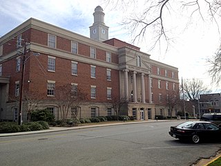
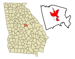
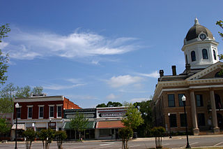
Baldwin County is a county located in the central portion of the U.S. state of Georgia. As of the 2020 census, its population was 43,799. The county seat is Milledgeville, which was developed along the Oconee River. Baldwin County is part of the Milledgeville micropolitan statistical area.

<span class="mw-page-title-main">Baldwin, Georgia</span> City in Georgia, United States

Baldwin is a city in Banks and Habersham counties in the U.S. state of Georgia. As of the 2010 census, the city had a population of 3,279, up from 2,425 at the 2000 census.

<span class="mw-page-title-main">Greensboro, Georgia</span> City in Georgia, United States

Greensboro is a city in and the county seat of Greene County, Georgia, United States. Its population was 3,648 as of the 2020 census. The city is located approximately halfway between Atlanta and Augusta on Interstate 20.

<span class="mw-page-title-main">Monticello, Georgia</span> City in Georgia, United States

Monticello is the largest city in and the county seat of Jasper County, Georgia, United States. The city includes historic buildings such as the Jasper County Courthouse, Monticello High School and the Monticello Historic District. The population was 2,657 at the 2010 census. It is 56 miles (90 km) southeast of Atlanta.

<span class="mw-page-title-main">Gray, Georgia</span> City in Georgia, United States

Gray is a city in Jones County, Georgia, United States. The population was 3,276 at the 2010 census, up from 1,811 at the 2000 census. In 2020, its population was 3,436. The city is the county seat of Jones County. It is part of the Macon metropolitan area.

<span class="mw-page-title-main">Dublin, Georgia</span> City in Georgia, United States

Dublin is a city and county seat of Laurens County, Georgia, United States. The population was 16,074 at the 2020 census.

<span class="mw-page-title-main">Madison, Georgia</span> City in Georgia, United States

Madison is a city in Morgan County, Georgia, United States. It is part of the Atlanta-Athens-Clarke-Sandy Springs Combined Statistical Area. The population was 4,447 at the 2020 census, up from 3,979 in 2010. The city is the county seat of Morgan County and the site of the Morgan County Courthouse.

<span class="mw-page-title-main">Watkinsville, Georgia</span> Town in Georgia, United States

Watkinsville is the largest town and county seat of Oconee County, Georgia, United States. As of the 2020 census, the town had a total population of 2,896. It served as the seat of Clarke County until 1872 when the county seat of that county was moved to Athens, a move which ultimately led to the creation of Oconee County in 1875. It is included in the Athens-Clarke County, Georgia Metropolitan Statistical Area.

<span class="mw-page-title-main">Eatonton, Georgia</span> City in Georgia, United States

Eatonton is a city in and county seat of Putnam County, Georgia, United States. As of the 2020 census, the city had a population of 6,307. It was named after William Eaton, an officer and diplomat involved in the First Barbary War. The name consists of his surname with the English suffix "ton", meaning "town".

<span class="mw-page-title-main">Tifton, Georgia</span> City in Georgia, United States

Tifton is a city in and the county seat of Tift County, Georgia, United States. The population was 17,045 at the 2020 census.

<span class="mw-page-title-main">Athens, Georgia</span> Consolidated city–county in Georgia, United States

Athens is a consolidated city-county and college town in the U.S. state of Georgia. Downtown Athens lies about 70 miles (110 km) northeast of downtown Atlanta. The University of Georgia, the state's flagship public university and an R1 research institution, is in Athens and contributed to its initial growth. In 1991, after a vote the preceding year, the original City of Athens abandoned its charter to form a unified government with Clarke County, referred to jointly as Athens–Clarke County where it is the county seat.

<span class="mw-page-title-main">Oconee River</span> River in the state of Georgia, U.S.

The Oconee River is a 220-mile-long (350 km) river in the U.S. state of Georgia. Its origin is in Hall County and it terminates where it joins the Ocmulgee River to form the Altamaha River near Lumber City at the borders of Montgomery County, Wheeler County, and Jeff Davis County. South of Athens, two forks, known as the Middle Oconee River and North Oconee River, which flow for 55–65 miles (89–105 km) upstream, converge to form the Oconee River. Milledgeville, the former capital city of Georgia, lies on the Oconee River.

<span class="mw-page-title-main">Lake Sinclair</span> Reservoir in Georgia, US

Lake Sinclair is a man-made lake in central Georgia near Eatonton. It is operated by Georgia Power.

<span class="mw-page-title-main">Georgia State Route 24</span> State highway in Georgia

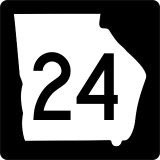
State Route 24 (SR 24) is a 221.8-mile-long (357.0 km) state highway that travels south-to-north in an S-shaped curve through portions of Bulloch, Screven, Burke, Jefferson, Washington, Baldwin, Putnam, Morgan, and Oconee counties in the east-central part of the U.S. state of Georgia. The highway connects Statesboro with the Watkinsville area, via Waynesboro, Louisville, Sandersville, Milledgeville, Eatonton, and Madison.

<span class="mw-page-title-main">Georgia State Route 29</span> State highway in Georgia

State Route 29 (SR 29) is a 98.1-mile-long (157.9 km) state highway that travels southeast-to-northwest through portions of Toombs, Montgomery, Treutlen, Laurens, Wilkinson, and Baldwin counties in the central part of the U.S. state of Georgia. The highway connects the Vidalia area with the Milledgeville area, via the Dublin area.

References

  1. "Milledgeville City Hall". 2017. Archived from the original on May 4, 2017. Retrieved May 16, 2017.
  2. "2020 U.S. Gazetteer Files". United States Census Bureau. Retrieved December 18, 2021.
  3. 1 2 "U.S. Census website". United States Census Bureau . Retrieved January 31, 2008.
  4. "US Board on Geographic Names". United States Geological Survey. October 25, 2007. Archived from the original on February 12, 2012. Retrieved January 31, 2008.
  5. "Find a County". National Association of Counties. Archived from the original on May 31, 2011. Retrieved June 7, 2011.
  6. "QuickFacts Milledgeville city, Georgia". United States Census Bureau. n.d. Archived from the original on June 26, 2019. Retrieved June 27, 2019.
  7. MICROPOLITAN STATISTICAL AREAS AND COMPONENTS, Office of Management and Budget, 2007-05-11. Accessed 2008-07-27.
  8. Wilson, Robert J. "Milledgeville". New Georgia Encyclopedia. Archived from the original on September 2, 2019. Retrieved December 1, 2019.
  9. "Georgia Penitentiary at Milledgeville".
  10. "Sherman's March: 150 years later".
  11. "A trip through Georgia's Civil War memories, past". May 28, 2017.
  12. "Civil War Milledgeville FAQ". Ina Dillard Russell Library. Georgia College & State University. Retrieved February 17, 2024.
  13. "St. Stephen's Episcopal Church, Milledgeville Georgia".
  14. "US Gazetteer files: 2010, 2000, and 1990". United States Census Bureau. February 12, 2011. Retrieved April 23, 2011.
  15. "Geographic Identifiers: 2010 Demographic Profile Data (G001): Milledgeville city, Georgia (Revision published Jan. 25, 2013)". U.S. Census Bureau, American Factfinder. Archived from the original on February 12, 2020. Retrieved October 28, 2013.
  16. "U.S. Climate Normals Quick Access – Station: Milledgeville, GA". National Oceanic and Atmospheric Administration. Retrieved March 4, 2023.
  17. "NOAA Online Weather Data – NWS Atlanta". National Weather Service. Retrieved March 4, 2023.
  18. "Census of Population and Housing". Census.gov. Retrieved June 4, 2015.
  19. "Explore Census Data". data.census.gov. Retrieved December 17, 2021.
  20. Hobbs, Billy (November 7, 2017). "Parham-Copelan upsets Thrower in mayor's race". The Union-Recorder. Archived from the original on February 9, 2018. Retrieved May 16, 2019.
  21. "Milledgeville City Hall - City Council". www.milledgevillega.us. Archived from the original on January 10, 2017. Retrieved January 10, 2017.
  22. "Milledgeville City Hall - Mayor's Office". www.milledgevillega.us. Archived from the original on January 10, 2017. Retrieved January 10, 2017.
  23. "Women in Economics: Lisa Cook" . Retrieved March 18, 2020.
  24. Hobbs, Billy (March 2021). "Milledgeville's first Black state senator, mayor honored". The Union-Recorder. Retrieved May 18, 2022.
  25. Staples, Gracie Bonds. "This Life: Author's dark tales an escape from darkness in her own life". The Atlanta Journal-Constitution.

Further reading

Government
General information