Danielsville, Georgia

Last updated
Danielsville, Georgia
Madison County Courthouse, Danielsville, GA.JPG
Madison County Courthouse
Madison County Georgia Incorporated and Unincorporated areas Danielsville Highlighted.svg
Location in Madison County and the state of Georgia
Coordinates: 34°7′27″N83°12′59″W / 34.12417°N 83.21639°W / 34.12417; -83.21639
Country United States
State Georgia
County Madison
Area
[1]
  Total1.48 sq mi (3.83 km2)
  Land1.45 sq mi (3.74 km2)
  Water0.03 sq mi (0.09 km2)
Elevation
728 ft (222 m)
Population
 (2020) [2]
  Total654
  Density452.28/sq mi (174.68/km2)
Time zone UTC-5 (Eastern (EST))
  Summer (DST) UTC-4 (EDT)
ZIP code
30633
Area code 706
FIPS code 13-21632 [3]
GNIS feature ID0331511 [4]
Website www.danielsvillega.com

Danielsville is a city in Madison County, Georgia, United States. The population was 654 at the 2020 census, [2] up from 560 in 2010. The city is the county seat of Madison County. [5]

Contents

History

Danielsville was named for General Allen Daniel (1772–1836), [6] major-general of the Fourth Division of Georgia Militia 1812-17 and both state senator and representative from Elbert and Madison counties. He was Speaker of the Georgia House of Representatives in 1822. His father was at one time thought to be a Captain Allen Daniel of Virginia, a veteran of the Revolutionary War, but this has been disproved. In 1812, Danielsville was designated seat of the newly formed Madison County. [7] Danielsville was incorporated as a town in 1817 and as a city in 1908. [8]

Lynching of Lent Shaw

On April 11, 1936, a 45-year-old Black father of eleven children, called Lent Shaw in newspaper accounts as his name is misspelled in court documents, was arrested by Madison County police and taken to the county jail in Danielsville. His accuser, a white woman aged 22, alleged that Shaw was the man who had attacked her on April 10. Shaw claimed that he was at home at the time of the alleged attack. [9]

By late evening, word had spread of Shaw's arrest, and a mob of about 150 white county residents gathered at the jail, demanding Shaw be released to them. Sheriff T. L. Henley tried to break up the mob unsuccessfully. The mob began prying apart the brick wall of the jail when 74-year-old judge Berry Mosely, who had been confined to bed with an illness, arrived and began talking down the mob. In the meantime, the county sheriff began rounding up deputies and called in nearby National Guard soldiers. Judge Mosely ordered the sheriff to take Shaw to Grady Memorial Hospital in Atlanta. When the National Guard soldiers arrived, they backed a truck up to the jail and sped away to Athens before the mob could react. No one was severely injured in the incident, but the damaged jail had to be repaired. [10] During transit, Shaw allegedly assaulted police officers escorting him, and the police responded by shooting him three times. [9]

Two weeks later, Shaw was brought back to Danielsville to face trial. The mob reappeared, and Mosely again ordered Shaw moved away for his safety, this time to Royston. That location was not far enough to protect him from the mob, which followed Shaw to the jail there. In April 1936, in the middle of the night, the mob stormed the jail, shot Shaw multiple times, and lynched him, leaving his hanging body to be found later. [11] His lynchers posed for pictures memorializing the barbaric event. [12] His death was the 468th lynching in Georgia since 1889.

Images of the lynching, featuring Shaw's battered corpse flanked by his attackers, were printed extensively by the national press including the Atlanta Daily World , The Crisis , The New York Times , and other newspapers. Shaw's lynching is referenced in archival material from the NAACP archives at the Library of Congress, and the story has been preserved and explored by historians of racial violence including Dr. Nell Irvin Painter and Dr. Amy Louise Wood. Photographs of the lynching are also featured in author Richard Wright's landmark book, 12 Million Black Voices . To date, none of Shaw's murderers have been publicly identified or brought to justice, though many of their faces are clearly displayed in photos of the lynching. [13]

Geography

Danielsville is located in central Madison County at 34°7′27″N83°12′59″W / 34.12417°N 83.21639°W / 34.12417; -83.21639 (34.124244, -83.216496). [14] The city lies 15 miles (24 km) northeast of Athens and the same distance southwest of Royston along U.S. Route 29. Georgia State Route 98 passes through the northeastern part of Danielsville, leading northwest 5 miles (8 km) to Ila and southeast 8 miles (13 km) to Comer.

According to the United States Census Bureau, Danielsville has a total area of 1.5 square miles (3.9 km2), of which 0.03 square miles (0.08 km2), or 2.30%, are water. [1] The city is drained to the south by tributaries of the South Fork of the Broad River, part of the Savannah River watershed.

Climate

Climate data for Danielsville, Georgia, 1991–2020 normals, extremes 1998present
MonthJanFebMarAprMayJunJulAugSepOctNovDecYear
Record high °F (°C)78
(26)
81
(27)
86
(30)
89
(32)
94
(34)
105
(41)
105
(41)
102
(39)
97
(36)
97
(36)
84
(29)
78
(26)
105
(41)
Mean maximum °F (°C)69.1
(20.6)
72.8
(22.7)
80.3
(26.8)
84.4
(29.1)
89.5
(31.9)
95.5
(35.3)
96.1
(35.6)
96.3
(35.7)
92.1
(33.4)
85.5
(29.7)
77.1
(25.1)
71.8
(22.1)
98.0
(36.7)
Mean daily maximum °F (°C)52.4
(11.3)
56.3
(13.5)
64.0
(17.8)
72.1
(22.3)
79.4
(26.3)
86.2
(30.1)
89.3
(31.8)
88.1
(31.2)
82.4
(28.0)
72.8
(22.7)
63.0
(17.2)
54.9
(12.7)
71.7
(22.1)
Daily mean °F (°C)42.1
(5.6)
45.3
(7.4)
52.1
(11.2)
59.8
(15.4)
67.8
(19.9)
75.4
(24.1)
78.8
(26.0)
77.7
(25.4)
71.8
(22.1)
61.4
(16.3)
51.4
(10.8)
44.8
(7.1)
60.7
(15.9)
Mean daily minimum °F (°C)31.7
(−0.2)
34.4
(1.3)
40.3
(4.6)
47.5
(8.6)
56.1
(13.4)
64.5
(18.1)
68.2
(20.1)
67.3
(19.6)
61.2
(16.2)
49.9
(9.9)
39.8
(4.3)
34.6
(1.4)
49.6
(9.8)
Mean minimum °F (°C)16.3
(−8.7)
20.9
(−6.2)
26.3
(−3.2)
33.3
(0.7)
42.4
(5.8)
56.7
(13.7)
61.6
(16.4)
61.4
(16.3)
50.3
(10.2)
35.5
(1.9)
25.9
(−3.4)
22.9
(−5.1)
15.2
(−9.3)
Record low °F (°C)6
(−14)
12
(−11)
17
(−8)
26
(−3)
35
(2)
44
(7)
56
(13)
54
(12)
42
(6)
26
(−3)
17
(−8)
6
(−14)
6
(−14)
Average precipitation inches (mm)4.72
(120)
4.66
(118)
4.54
(115)
3.63
(92)
3.81
(97)
4.27
(108)
4.28
(109)
4.23
(107)
4.36
(111)
3.58
(91)
4.18
(106)
4.94
(125)
15.20
(386)
Average snowfall inches (cm)0.6
(1.5)
0.7
(1.8)
0.5
(1.3)
0.0
(0.0)
0.0
(0.0)
0.0
(0.0)
0.0
(0.0)
0.0
(0.0)
0.0
(0.0)
0.0
(0.0)
0.0
(0.0)
0.3
(0.76)
2.1
(5.36)
Average precipitation days (≥ 0.01 in)9.810.510.28.69.310.910.710.37.66.58.611.0114.0
Average snowy days (≥ 0.1 in)0.70.50.10.00.00.00.00.00.00.00.00.31.6
Source 1: NOAA [15]
Source 2: National Weather Service (mean maxima/minima 20062020) [16]

Demographics

Historical population
CensusPop.Note
1880 128
1890 14916.4%
1900 19430.2%
1910 32366.5%
1920 3559.9%
1930 296−16.6%
1940 33312.5%
1950 298−10.5%
1960 36221.5%
1970 3784.4%
1980 354−6.3%
1990 318−10.2%
2000 45743.7%
2010 56022.5%
2020 65416.8%
U.S. Decennial Census [17]

As of the census [3] of 2000, there were 457 people, 193 households, and 119 families residing in the city. The population density was 412.4 inhabitants per square mile (159.2/km2). There were 216 housing units at an average density of 194.9 per square mile (75.3/km2). The racial makeup of the city was 95.40% White, 2.19% Black or African American, 0.44% Native American, 1.09% from other races, and 0.88% from two or more races. 3.50% of the population were Hispanic or Latino of any race.

There were 193 households, out of which 29.5% had children under the age of 18 living with them, 49.2% were married couples living together, 9.8% had a female householder with no husband present, and 38.3% were non-families. 34.7% of all households were made up of individuals, and 18.1% had someone living alone who was 65 years of age or older. The average household size was 2.25 and the average family size was 2.92.

In the city, the population was spread out, with 22.8% under the age of 18, 9.6% from 18 to 24, 34.1% from 25 to 44, 18.8% from 45 to 64, and 14.7% who were 65 years of age or older. The median age was 34 years. For every 100 females, there were 92.0 males. For every 100 females age 18 and over, there were 91.8 males.

The median income for a household in the city was $37,639, and the median income for a family was $43,542. Males had a median income of $30,469 versus $22,188 for females. The per capita income for the city was $14,086. About 8.8% of families and 12.4% of the population were below the poverty line, including 13.7% of those under age 18 and 11.8% of those age 65 or over.

Education

Madison County School District

The Madison County School District holds pre-school to grade twelve, and consists of five elementary schools, a middle school, and a high school. [18] The district has 290 full-time teachers and over 4,621 students. [19]

Notable people

Related Research Articles

<span class="mw-page-title-main">Madison County, Florida</span> County in Florida, United States

Madison County is a county located in the north central portion of the state of Florida, and borders the state of Georgia to the north. As of the 2020 census, the population was 17,968. Its county seat is also called Madison.

<span class="mw-page-title-main">Lawrence County, Missouri</span> County in Missouri, United States

Lawrence County is located in the southwest portion of the U.S. state of Missouri, in the area of the Ozarks. As of the 2020 census, the population was 38,001. Its county seat is Mount Vernon. The county was organized in 1845 and named for James Lawrence, a naval officer from the War of 1812 known for his battle cry, "Don't give up the ship!"

<span class="mw-page-title-main">Madison County, Georgia</span> County in Georgia, United States

Madison County is a county located in the northeastern part of the U.S. state of Georgia. As of the 2020 census, the population was 30,120. The county seat is Danielsville. The county was created on December 5, 1811. The county's largest city is Comer with a population of 1,200.

<span class="mw-page-title-main">Franklin County, Georgia</span> County in Georgia, United States

Franklin County is a county located in the northeastern part of the U.S. state of Georgia. As of the 2020 census, the population was 23,424. The county seat is Carnesville. On February 25, 1784, Franklin and Washington became Georgia's eighth and ninth counties, with Franklin named in honor of patriot Benjamin Franklin.

<span class="mw-page-title-main">Abbeville, Alabama</span> City in and county seat of Henry County, Alabama

Abbeville is a city in and the county seat of Henry County, in the southeast part of Alabama, United States. It is part of the Dothan, Alabama Metropolitan Statistical Area. At the 2020 census, the population was 2,358.

<span class="mw-page-title-main">Trenton, Florida</span> City in Florida, United States

Trenton is a city and the county seat of Gilchrist County, Florida, United States. The population was 2,015 as of the 2020 census.

<span class="mw-page-title-main">Royston, Georgia</span> City in Georgia, United States

Royston is a city in Franklin, Hart, and Madison counties in the U.S. state of Georgia. The population was 2,649 at the 2020 census.

<span class="mw-page-title-main">Hartwell, Georgia</span> City in Georgia, United States

Hartwell is a city in Hart County, Georgia, United States. The population was 4,469 at the 2010 census. The city is the county seat of Hart County.

<span class="mw-page-title-main">Colbert, Georgia</span> City in Georgia, United States

Colbert is a city in Madison County, Georgia, United States. The population was 630 at the 2020 census.

<span class="mw-page-title-main">Comer, Georgia</span> City in Georgia, United States

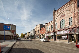
Comer is a city in Madison County, Georgia, United States. It had a population of 1,512 as of the 2020 census, up from 1,126 in 2010. Comer is the largest city in Madison County based on population and total land area. The city is included in the Athens-Clarke County Metropolitan Statistical Area, part of the Atlanta-Athens-Clarke County-Sandy Springs Combined Statistical Area.

<span class="mw-page-title-main">Ila, Georgia</span> City in Georgia, United States

Ila is a city in Madison County, Georgia, United States. The population was 350 at the 2020 census.

<span class="mw-page-title-main">Madison, Georgia</span> City in Georgia, United States

Madison is a city in Morgan County, Georgia, United States. It is part of the Atlanta-Athens-Clarke-Sandy Springs Combined Statistical Area. The population was 4,447 at the 2020 census, up from 3,979 in 2010. The city is the county seat of Morgan County and the site of the Morgan County Courthouse.

<span class="mw-page-title-main">McRae, Georgia</span> City in Georgia, United States

McRae was a city in and the county seat of Telfair County, Georgia, United States. It was designated as the seat in 1871, after being established the previous year as a station on the Macon and Brunswick Railroad. Upon the city's merger with adjacent Helena in 2015, the new county seat is the combined city of McRae-Helena.

<span class="mw-page-title-main">Pendleton, Indiana</span> Town in Indiana, United States

Pendleton is a town in Fall Creek Township, Madison County, Indiana, United States. The population was 4,717 at the 2020 census, up from 4,253 in 2010.

<span class="mw-page-title-main">Pierce City, Missouri</span> City in Missouri, United States

Pierce City, formerly Peirce City, is a city in southwest Lawrence and northwest Barry counties, in southwest Missouri, United States. The population was 1,292 at the 2010 census. In 2010, the town annexed property along Route 97 into Barry County to a point just north of U.S. Route 60. It was estimated to be 1,309 by the City of Pierce City as of July 1, 2019.

<span class="mw-page-title-main">Clyde, North Carolina</span> Town in North Carolina, United States

Clyde is a town in Haywood County, North Carolina, United States. The 2010 census recorded the population at 1,223 people. It is part of the Asheville Metropolitan Statistical Area.

<span class="mw-page-title-main">Urbana, Ohio</span> City in Ohio, United States

Urbana is a city in and the county seat of Champaign County, Ohio, United States, about 34 miles (55 km) northeast of Dayton and 41 miles (66 km) west of Columbus. The population was 11,115 at the 2020 census. It is the principal city of the Urbana micropolitan area. Urbana was laid out in 1805, and for a time in 1812 was the headquarters of the Northwestern army during the War of 1812. It is the burial place of the explorer and Indian fighter Simon Kenton. The city was home to Urbana University and Curry Normal and Industrial Institute, a school for African American students.

<span class="mw-page-title-main">North Alamo, Texas</span> Census-designated place in Texas, United States

North Alamo is a census-designated place (CDP) in Hidalgo County, Texas, United States. The population was 3,235 at the 2010 United States Census. It is part of the McAllen–Edinburg–Mission Metropolitan Statistical Area.

<span class="mw-page-title-main">Baileys Harbor, Wisconsin</span> Town in Wisconsin, United States

Baileys Harbor is a town in Door County, Wisconsin, United States. The population was 1,003 at the 2000 census. The unincorporated community of Peninsula Center is located in the town. The census-designated place of Baileys Harbor is also located with the town.

<span class="mw-page-title-main">Goodlettsville, Tennessee</span> City in Tennessee, United States

Goodlettsville is a city in Davidson and Sumner counties in the U.S. state of Tennessee. It was incorporated as a city in 1958 with a population of just over 3,000 residents; in 2020, the population was 17,789. It is part of the Nashville metropolitan area.

References

  1. 1 2 "2022 U.S. Gazetteer Files: Georgia". United States Census Bureau. Retrieved January 23, 2023.
  2. 1 2 "P1. Race – Danielsville city, Georgia: 2020 DEC Redistricting Data (PL 94-171)". U.S. Census Bureau. Retrieved January 23, 2023.
  3. 1 2 "U.S. Census website". United States Census Bureau . Retrieved 2008-01-31.
  4. "US Board on Geographic Names". United States Geological Survey. 2007-10-25. Retrieved 2008-01-31.
  5. "Find a County". National Association of Counties. Archived from the original on 2011-05-31. Retrieved 2011-06-07.
  6. Gannett, Henry (1905). The Origin of Certain Place Names in the United States. Govt. Print. Off. pp.  99.
  7. Krakow, Kenneth K. (1975). Georgia Place-Names: Their History and Origins (PDF). Macon, GA: Winship Press. p. 58. ISBN   0-915430-00-2.
  8. Hellmann, Paul T. (May 13, 2013). Historical Gazetteer of the United States. Routledge. p. 227. ISBN   978-1135948597 . Retrieved 30 November 2013.
  9. 1 2 Silversmith, Shondiin. "Confronting the past: A young man tries to understand the lynching of his great-grandfather". The Arizona Republic. Retrieved May 8, 2021.
  10. The Associated Press. "Troops save Negro from Georgia mob", The New York Times . April 12, 1936. Page 1.
  11. MADEO. "Apr. 28, 1936 | Lint Shaw Lynched in Georgia Eight Hours Before Trial". calendar.eji.org. Retrieved 2021-05-08.
  12. "Lint Shaw, killed by a mob near Royston, Georgia". NYPL Digital Collections. Retrieved May 8, 2021.
  13. "Races: 468th & 469th; 248th", Time . May 11, 1936. Retrieved April 12, 2011.
  14. "US Gazetteer files: 2010, 2000, and 1990". United States Census Bureau. 2011-02-12. Retrieved 2011-04-23.
  15. "U.S. Climate Normals Quick Access – Station: Danielsville, GA". National Oceanic and Atmospheric Administration. Retrieved March 4, 2023.
  16. "NOAA Online Weather Data – NWS Atlanta". National Weather Service. Retrieved March 4, 2023.
  17. "Census of Population and Housing". Census.gov. Retrieved June 4, 2015.
  18. Georgia Board of Education [ permanent dead link ], Retrieved June 23, 2010.
  19. School Stats, Retrieved June 23, 2010.