Jeff Davis County, Georgia

Last updated

Jeff Davis County
County
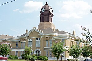
Jeff Davis County courthouse, Hazlehurst, GA, US.jpg
County courthouse
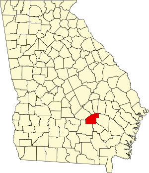
Map of Georgia highlighting Jeff Davis County.svg
Location within the U.S. state of Georgia
Georgia in United States.svg
Georgia's location within the U.S.
Coordinates: 31°48′N82°38′W / 31.8°N 82.64°W / 31.8; -82.64
CountryFlag of the United States.svg United States
StateFlag of Georgia (U.S. state).svg  Georgia
FoundedAugust 18, 1905;119 years ago (1905)
Named for Jefferson Davis
Seat Hazlehurst
Largest cityHazlehurst
Area
  Total335 sq mi (870 km2)
  Land331 sq mi (860 km2)
  Water4.7 sq mi (12 km2)  1.4%
Population
 (2020)
  Total14,779
  Density45/sq mi (17/km2)
Time zone UTC−5 (Eastern)
  Summer (DST) UTC−4 (EDT)
Congressional district 12th
Website www.hazlehurst-jeffdavis.com

Jeff Davis County is a county located in the southeastern part of the U.S. state of Georgia. As of the 2020 census, the population was 14,779. [1] The county seat is Hazlehurst. [2] The county was created on August 18, 1905, and named for Jefferson Davis, the only Confederate president. [3]

Contents

Geography

According to the U.S. Census Bureau, the county has a total area of 335 square miles (870 km2), of which 331 square miles (860 km2) is land and 4.7 square miles (12 km2) (1.4%) is water. [4]

Most of the northern border area, as well as part of the western border of Jeff Davis County, from northeast of Hazlehurst to west of Denton, is located in the Lower Ocmulgee River sub-basin of the Altamaha River basin. Most of the eastern corner of the county, east of Hazlehurst and north of Graham, is located in the Altamaha River sub-basin of the larger basin by the same name. The central and southeastern portion of Jeff Davis County, south of Hazlehurst, is located in the Little Satilla River sub-basin of the St. Marys-Satilla River basin. The remaining central and southern portion of the county is located in the Satilla River sub-basin of the St. Marys-Satilla River basin. [5]

Major highways

Adjacent counties

Communities

Cities

Census-designated place

Economy

Jeff Davis County had an estimated $164,341,000 in retail sales in 2017. [6] Agriculture is a major factor of the economy. Cotton and peanuts, along with the formerly more significant tobacco, are the primary commercial crops. Timber, too, is an important product. [7]

Demographics

Historical population
CensusPop.Note
1910 6,050
1920 7,32221.0%
1930 8,11810.9%
1940 8,8418.9%
1950 9,2995.2%
1960 8,914−4.1%
1970 9,4255.7%
1980 11,47321.7%
1990 12,0324.9%
2000 12,6845.4%
2010 15,06818.8%
2020 14,779−1.9%
2023 (est.)14,906 [8] 0.9%
U.S. Decennial Census [9]
1790-1880 [10] 1890-1910 [11]
1920-1930 [12] 1930-1940 [13]
1940-1950 [14] 1960-1980 [15]
1980-2000 [16] 2010 [17]
Jeff Davis County racial composition as of 2020 [18]
RaceNum.Perc.
White (non-Hispanic)9,95067.33%
Black or African American (non-Hispanic)2,29315.52%
Native American 260.18%
Asian 500.34%
Pacific Islander 70.05%
Other/Mixed 4062.75%
Hispanic or Latino 2,04713.85%

As of the 2020 United States census, there were 14,779 people, 5,279 households, and 3,790 families residing in the county.

Politics

United States presidential election results for Jeff Davis County, Georgia [19]
Year Republican Democratic Third party
No.%No.%No.%
2020 4,69581.31%1,02817.80%510.88%
2016 4,10480.17%90117.60%1142.23%
2012 3,99674.85%1,27523.88%681.27%
2008 3,86773.16%1,35625.65%631.19%
2004 3,54973.25%1,27726.36%190.39%
2000 2,79766.26%1,37932.67%451.07%
1996 1,79647.08%1,57641.31%44311.61%
1992 1,94739.32%2,03141.01%97419.67%
1988 2,05062.03%1,24237.58%130.39%
1984 2,23361.80%1,38038.20%00.00%
1980 1,19135.97%2,05962.19%611.84%
1976 62220.55%2,40579.45%00.00%
1972 1,85786.01%30213.99%00.00%
1968 57719.82%37612.92%1,95867.26%
1964 1,87571.56%74528.44%00.00%
1960 40232.76%82567.24%00.00%
1956 24712.98%1,65687.02%00.00%
1952 36721.72%1,32378.28%00.00%
1948 707.73%61167.51%22424.75%
1944 12014.00%73786.00%00.00%
1940 10112.64%69687.11%20.25%
1936 9312.85%63187.15%00.00%
1932 504.06%1,17995.70%30.24%
1928 18036.36%31563.64%00.00%
1924 3923.35%12273.05%63.59%
1920 30353.82%26046.18%00.00%
1916 143.79%29981.03%5615.18%
1912 195.60%26879.06%5215.34%

See also

Related Research Articles

<span class="mw-page-title-main">Montgomery County, Georgia</span> County in Georgia, United States

Montgomery County is a county located in the central portion of the U.S. state of Georgia. As of the 2020 census, the population was 8,610. The county seat is Mount Vernon. Montgomery County is part of the Vidalia, GA micropolitan statistical area.

<span class="mw-page-title-main">Wheeler County, Georgia</span> County in Georgia, United States

Wheeler County is a county located in the central portion of the U.S. state of Georgia. As of the 2020 census, the population was 7,471. The county seat is Alamo. The county is one of the most impoverished counties in the nation. The American Community Survey's 2009–2013 average reports that the county's per-capita income of $8,948 makes it the poorest county in the United States by this metric. The measurement however is misleading as Wheeler County is the site of Wheeler Correctional Facility, a large prison with a capacity of 2,874 prisoners, about 40 percent of the county's total population. Most prisoners have little income. The prison was opened in 1998 and the prison population may also account for the increased population of the county in the early 2000s.

<span class="mw-page-title-main">Wayne County, Georgia</span> County in Georgia, United States

Wayne County is a county located in the southeastern part of the U.S. state of Georgia. As of the 2020 census, the population was 30,144. The county seat is Jesup.

<span class="mw-page-title-main">Washington County, Georgia</span> County in Georgia, United States

Washington County is a county located in the U.S. state of Georgia. As of the 2020 census, the population was 19,988. The county seat is Sandersville. The county was established on February 25, 1784. It was named for Revolutionary War general George Washington.

<span class="mw-page-title-main">Twiggs County, Georgia</span> County in Georgia, United States

Twiggs County is a county located in the central portion of the U.S. state of Georgia. As of the 2020 census, the population was 8,022. The county seat is Jeffersonville. The county was created on December 14, 1809, and named for American Revolutionary War general John Twiggs.

<span class="mw-page-title-main">Treutlen County, Georgia</span> County in Georgia, United States

Treutlen County is a county located in the east central. & Magnolia midlands portion of the U.S. state of Georgia. As of the 2020 census, the population was 6,406. The county seat is Soperton. It is host to the Million Pines Arts and Crafts Festival which occurs during the first weekend in November.

<span class="mw-page-title-main">Toombs County, Georgia</span> County in Georgia, United States

Toombs County is a county located in the east central portion of the U.S. state of Georgia. As of the 2020 census, the population was 27,030. The county seat is Lyons and the largest city is Vidalia. The county was created on August 18, 1905.

<span class="mw-page-title-main">Telfair County, Georgia</span> County in Georgia, United States

Telfair County is a county located in the central portion of the U.S. state of Georgia. As of the 2020 census, the population was 12,477. The largest city and county seat is McRae-Helena.

<span class="mw-page-title-main">Spalding County, Georgia</span> County in Georgia, United States

Spalding County is a county located in the west central portion of the U.S. state of Georgia. As of the 2020 census, the population was 67,306. The county seat is Griffin. The county was created December 20, 1851, and named for former United States representative and senator Thomas Spalding.

<span class="mw-page-title-main">Pierce County, Georgia</span> County in Georgia, United States

Pierce County is a county located in the southeastern part of the U.S. state of Georgia. As of the 2020 census, the population was 19,716. The county seat is Blackshear.

<span class="mw-page-title-main">Laurens County, Georgia</span> County in Georgia, United States

Laurens County is a county located in the central part of the U.S. state of Georgia. As of the 2020 census, the population was 49,570, up from 48,434 in 2010. The county seat is Dublin. The county was founded on December 10, 1807, and named after Lieutenant Colonel John Laurens, an American soldier and statesman from South Carolina during the American Revolutionary War.

<span class="mw-page-title-main">Lamar County, Georgia</span> County in Georgia, United States

Lamar County is a county located in the west central portion of the U.S. state of Georgia. As of the 2020 census, the population was 18,500. The county seat is Barnesville.

<span class="mw-page-title-main">Johnson County, Georgia</span> County in Georgia, United States

Johnson County is a county located along the oconee River in the U.S. state of Georgia. As of the 2020 census, the population was 9,189. The county seat is Wrightsville. Johnson County is part of the Dublin, Georgia, micropolitan statistical area.

<span class="mw-page-title-main">Coffee County, Georgia</span> County in Georgia, United States

Coffee County is a county located in the southeastern part of the U.S. state of Georgia. As of the 2020 census, the population was 43,092, up from 42,356 at the 2010 census. The county seat is Douglas.

<span class="mw-page-title-main">Charlton County, Georgia</span> County in Georgia, United States

Charlton County is the southernmost county of the U.S. state of Georgia, located in the southeastern part of the state. As of the 2020 census, the population was 12,518. The county seat is Folkston.

<span class="mw-page-title-main">Brantley County, Georgia</span> County in Georgia, United States

Brantley County is a county located in the southeastern part of the U.S. state of Georgia. As of the 2020 census, the population was 18,021. The county seat is Nahunta. Brantley County is part of the Brunswick, Georgia metropolitan statistical area.

<span class="mw-page-title-main">Bleckley County, Georgia</span> County in Georgia, United States

Bleckley County is a county located in the central portion of the U.S. state of Georgia. As of the 2020 census, the population was 12,583. The county seat is Cochran.

<span class="mw-page-title-main">Ben Hill County, Georgia</span> County in Georgia, United States

Ben Hill County is a county located in the U.S. state of Georgia. As of the 2020 census, the population was 17,194. The county seat is Fitzgerald. The county was organized in 1906. It is named after Benjamin Harvey Hill, a former Confederate and United States Senator.

<span class="mw-page-title-main">Bacon County, Georgia</span> County in Georgia, United States

Bacon County is a county located in the southeastern part of the U.S. state of Georgia. As of the 2020 census, the population was 11,140. The county seat is Alma.

<span class="mw-page-title-main">Appling County, Georgia</span> County in Georgia, United States

Appling County is a county located in the southeastern part of the U.S. state of Georgia. As of the 2020 census, the population was 18,444. The county seat is Baxley.
References

  1. "Census - Geography Profile: Jeff Davis County, Georgia". United States Census Bureau . Retrieved December 27, 2022.
  2. "Find a County". National Association of Counties. Archived from the original on May 31, 2011. Retrieved June 7, 2011.
  3. Krakow, Kenneth K. (1975). Georgia Place-Names: Their History and Origins (PDF). Macon, GA: Winship Press. p. 119. ISBN   0-915430-00-2. Archived (PDF) from the original on September 17, 2003.
  4. "US Gazetteer files: 2010, 2000, and 1990". United States Census Bureau. February 12, 2011. Retrieved April 23, 2011.
  5. "Georgia Soil and Water Conservation Commission Interactive Mapping Experience". Georgia Soil and Water Conservation Commission. Archived from the original on October 3, 2018. Retrieved November 27, 2015.
  6. "Census Quick Facts: Jeff Davis County". United States Census Bureau . Retrieved April 2, 2024.
  7. "Jeff Davis County". New Georgia Encyclopedia. Retrieved April 2, 2024.
  8. "Annual Estimates of the Resident Population for Counties: April 1, 2020 to July 1, 2023". United States Census Bureau. Retrieved March 31, 2024.
  9. "Decennial Census of Population and Housing by Decades". United States Census Bureau.
  10. "1880 Census Population by Counties 1790-1800" (PDF). United States Census Bureau. 1880.
  11. "1910 Census of Population - Georgia" (PDF). United States Census Bureau. 1910.
  12. "1930 Census of Population - Georgia" (PDF). United States Census Bureau. 1930.
  13. "1940 Census of Population - Georgia" (PDF). United States Census Bureau. 1940.
  14. "1950 Census of Population - Georgia -" (PDF). United States Census Bureau. 1950.
  15. "1980 Census of Population - Number of Inhabitants - Georgia" (PDF). United States Census Bureau. 1980.
  16. "2000 Census of Population - Population and Housing Unit Counts - Georgia" (PDF). United States Census Bureau. 2000.
  17. "State & County QuickFacts". United States Census Bureau. Archived from the original on June 7, 2011. Retrieved June 23, 2014.
  18. "Explore Census Data". data.census.gov. Retrieved December 18, 2021.
  19. Leip, David. "Dave Leip's Atlas of U.S. Presidential Elections". uselectionatlas.org. Retrieved March 20, 2018.

31°48′N82°38′W / 31.80°N 82.64°W / 31.80; -82.64