Savannah is the oldest city in the U.S. state of Georgia and the county seat of Chatham County. Established in 1733 on the Savannah River, the city of Savannah became the British colonial capital of the Province of Georgia and later the first state capital of Georgia. A strategic port city in the American Revolution and during the American Civil War, Savannah is today an industrial center and an important Atlantic seaport. It is Georgia's fifth most populous city, with a 2020 U.S. census population of 147,780. The Savannah metropolitan area, Georgia's third-largest, had a 2020 population of 404,798.

Wayne County is a county located in the southeastern part of the U.S. state of Georgia. As of the 2020 census, the population was 30,144. The county seat is Jesup.

Twiggs County is a county located in the central portion of the U.S. state of Georgia. As of the 2020 census, the population was 8,022. The county seat is Jeffersonville. The county was created on December 14, 1809, and named for American Revolutionary War general John Twiggs.

Tift County is a county located in the south central portion of the U.S. state of Georgia. As of the 2020 census, the population was 41,344. The county seat is Tifton.

Long County is a county located in the U.S. state of Georgia. The county seat is Ludowici. Long County is part of the Hinesville-Fort Stewart Metropolitan Statistical Area. The constitutional amendment to create the county was proposed August 14, 1920, and ratified November 2, 1920. The county is named after Crawford Long (1815–1878), an American surgeon and pharmacist who was the first to use diethyl ether as an anaesthetic.

Liberty County is a county in the U.S. state of Georgia. As of the 2020 census, the population is 65,256. The county seat is Hinesville.

Houston County is a county located in the central portion of the U.S. state of Georgia. The population was 163,633 at the 2020 census. Its county seat is Perry; the city of Warner Robins is substantially larger in both area and population.

Glynn County is located in the southeastern part of the U.S. state of Georgia. As of the 2020 census, the population was 84,499. The county seat is Brunswick. Glynn County is part of the Brunswick, Georgia Metropolitan Statistical Area.

Dooly County is a county located in the central portion of the U.S. state of Georgia. As of the 2020 census, the population was 11,208. The county seat is Vienna. The county was created by an act of the Georgia General Assembly on May 15, 1821, and named for Colonel John Dooly, a Georgia American Revolutionary War fighter. It was one of the original landlot counties created from land ceded from the Creek Nation.

Chatham County is located in the U.S. state of Georgia, on the state's Atlantic coast. The county seat and largest city is Savannah. One of the original counties of Georgia, Chatham County was created February 5, 1777, and is named after William Pitt, 1st Earl of Chatham.

Bulloch County is a county located in the southeastern part of the U.S. state of Georgia. As of the 2020 census, the population was 81,099, up from 70,217 in 2010. The county seat is Statesboro. With Evans County, Bulloch forms part of the Statesboro micropolitan statistical area, a component of the Savannah–Hinesville–Statesboro combined statistical area.

Brantley County is a county located in the southeastern part of the U.S. state of Georgia. As of the 2020 census, the population was 18,021. The county seat is Nahunta. Brantley County is part of the Brunswick, Georgia metropolitan statistical area.

Bleckley County is a county located in the central portion of the U.S. state of Georgia. As of the 2020 census, the population was 12,583. The county seat is Cochran.

Brunswick is a city in and the county seat of Glynn County in the U.S. state of Georgia. As the primary urban and economic center of the lower southeast portion of Georgia, it is the second-largest urban area on the Georgia coastline after Savannah and contains the Brunswick Old Town Historic District. At the 2020 U.S. census, the population of the city proper was 15,210; the Brunswick metropolitan area's population as of 2020 was 113,495.

Hinesville is a city and county seat of Liberty County, Georgia, United States, located on the Atlantic coastal plain. The population was 33,437 at the 2010 census and an estimated 33,273 in 2019. By 2020, its population was 34,891. It is the principal city of the Hinesville metropolitan area, which comprises all of Liberty County, including the Fort Stewart army installation, plus neighboring Long County.
The Hinesville metropolitan area, officially the Hinesville metropolitan statistical area and previously the Hinesville–Ft. Stewart metropolitan statistical area, is defined by the U.S. Office of Management and Budget as a metropolitan statistical area consisting of two counties, Liberty and Long, in the U.S. state of Georgia. It is anchored by the city of Hinesville and encompasses all of Fort Stewart, one of the largest U.S. Army installations in the United States.

The Deptford culture was an archaeological culture in southeastern North America characterized by the appearance of elaborate ceremonial complexes, increasing social and political complexity, mound burial, permanent settlements, population growth, and an increasing reliance on cultigens.
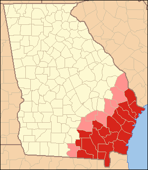
Coastal Georgia is a ten-county region in the U.S. state of Georgia, bordering South Carolina and Florida. It comprises a substantial portion of the state's Lower Coastal Plain. The region's largest city and metropolitan area is Savannah. Coastal Georgia's total population was 731,630 according to the 2020 United States census.
The Savannah metropolitan area, officially named the Savannah metropolitan statistical area by the U.S. Office of Management and Budget, is a metropolitan statistical area in the U.S. state of Georgia. It is centered on the city of Savannah and encompasses three counties: Bryan, Chatham, and Effingham.

The North American Southern Coastal Plain is a Level III ecoregion designated by the Environmental Protection Agency (EPA) in six U.S. states. The region stretches across the Gulf coast from eastern Louisiana to Florida, forms the majority of Florida, and forms the coastlines of Georgia and much of South Carolina. It has been divided into twelve Level IV ecoregions.