Southern Rivers

Last updated
Map of the region Map of Georgia highlighting Southern Rivers.gif
Map of the region

Southern Rivers is an area in southwest Georgia, United States, spreading north into West Georgia and West Central Georgia.

Geography

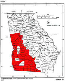
The Southern Rivers region constitutes the southwest corner of the state of Georgia and is made up of the following counties:


Related Research Articles

<span class="mw-page-title-main">Thomas County, Georgia</span> County in Georgia, United States

Thomas County is a county located in the U.S. state of Georgia. As of the 2020 census the population was 45,798. The county seat is Thomasville. Thomas County comprises the Thomasville, GA micropolitan statistical area.

<span class="mw-page-title-main">Talbot County, Georgia</span> County in Georgia, United States

Talbot County is a county located in the west central portion of the U.S. state of Georgia. The 2020 census showed a population of 5,733. The county seat and largest city is Talbotton.

<span class="mw-page-title-main">Hinesville, Georgia</span> City in Georgia, United States

Hinesville is a city and county seat of Liberty County, Georgia, United States, located on the Atlantic coastal plain. The population was 33,437 at the 2010 census and an estimated 33,273 in 2019. By 2020, its population was 34,891. It is the principal city of the Hinesville metropolitan area, which comprises all of Liberty County, including the Fort Stewart army installation, plus neighboring Long County.

<span class="mw-page-title-main">Chattahoochee River</span> River in Georgia, United States

The Chattahoochee River forms the southern half of the Alabama and Georgia border, as well as a portion of the Florida and Georgia border. It is a tributary of the Apalachicola River, a relatively short river formed by the confluence of the Chattahoochee and Flint rivers and emptying from Florida into Apalachicola Bay in the Gulf of Mexico. The Chattahoochee River is about 430 miles (690 km) long. The Chattahoochee, Flint, and Apalachicola rivers together make up the Apalachicola–Chattahoochee–Flint River Basin. The Chattahoochee makes up the largest part of the ACF's drainage basin.

<span class="mw-page-title-main">U.S. Route 84</span> United States Numbered Highway in the United States

U.S. Route 84 (US 84) is an east–west United States Numbered Highway that started as a short Georgia–Alabama route in the original 1926 scheme. Later, in 1941, it had been extended all the way to Colorado. The highway's eastern terminus is a short distance east of Midway, Georgia, at an Interchange with Interstate 95 (I-95). The road continues toward the nearby Atlantic Ocean as a county road. Its western terminus is in Pagosa Springs, Colorado, at an intersection with US 160.

<span class="mw-page-title-main">Blue Ridge Mountains</span> Mountain range in the Eastern U.S.

The Blue Ridge Mountains are a physiographic province of the larger Appalachian Highlands range. The mountain range is located in the Eastern United States, and extends 550 miles southwest from southern Pennsylvania through Maryland, West Virginia, Virginia, North Carolina, South Carolina, Tennessee, and Georgia. This province consists of northern and southern physiographic regions, which divide near the Roanoke River gap. To the west of the Blue Ridge, between it and the bulk of the Appalachians, lies the Great Appalachian Valley, bordered on the west by the Ridge and Valley province of the Appalachian range.

<span class="mw-page-title-main">Shida Kartli</span> Region (mkhare) of Georgia

Shida Kartli is a landlocked administrative region (Mkhare) in eastern Georgia. It comprises a central part of the historical-geographic province of Shida Kartli. With an area of 5,729 square kilometres (2,212 sq mi), Shida Kartli is the 8th largest Georgian region by land area. With 284,081 inhabitants, it is Georgia's seventh-most-populous region. Shida Kartli's capital and largest city, Gori, is the 5th largest city in Georgia.

<span class="mw-page-title-main">Eastern Continental Divide</span> Hydrological divide in eastern North America

The Eastern Continental Divide, Eastern Divide or Appalachian Divide is a hydrological divide in eastern North America that separates the easterly Atlantic Seaboard watershed from the westerly Gulf of Mexico watershed. The divide nearly spans the United States from south of Lake Ontario through the Florida peninsula, and consists of raised terrain including the Appalachian Mountains to the north, the southern Piedmont Plateau and lowland ridges in the Atlantic Coastal Plain to the south. Water including rainfall and snowfall, lakes, streams and rivers on the eastern/southern side of the divide drains to the Atlantic Ocean; water on the western/northern side of the divide drains to the Gulf of Mexico. The ECD is one of six continental hydrological divides of North America which define several drainage basins, each of which drains to a particular body of water.

<span class="mw-page-title-main">Blackwater river</span> Slow-moving, dark-colored river flowing through forested swamps or wetlands

A blackwater river is a type of river with a slow-moving channel flowing through forested swamps or wetlands. Most major blackwater rivers are in the Amazon Basin and the Southern United States. The term is used in fluvial studies, geology, geography, ecology, and biology. Not all dark rivers are blackwater in that technical sense. Some rivers in temperate regions, which drain or flow through areas of dark black loam, are simply black due to the color of the soil; these rivers are black mud rivers. There are also black mud estuaries.

The "Old Southwest" is an informal name for the southwestern frontier territories of the United States from the American Revolutionary War c. 1780, through the early 1800s, at which point the US had acquired the Louisiana Territory, pushing the southwestern frontier toward what is today known as the Southwest.

<span class="mw-page-title-main">U.S. Route 1 in Georgia</span> Highway in Georgia

U.S. Highway 1 (US 1) in the U.S. state of Georgia, which is concurrent for almost its entire length with State Route 4 (SR 4), is a highway traversing south–north through portions of Charlton, Ware, Bacon, Appling, Toombs, Emanuel, Jefferson, and Richmond counties in the southeastern and east-central parts of the state. In Georgia, the highway originates at US 1/US 23/US 301/State Road 15 (SR 15) at the St. Marys River and the Florida state line, where SR 4 reach their southern terminus. It travels to the Savannah River at South Carolina state line in Augusta where the route continues to North Augusta, South Carolina. Here, SR 10 reaches its eastern terminus.

<span class="mw-page-title-main">Lake Seminole</span>

Lake Seminole is a reservoir located in the southwest corner of Georgia along its border with Florida, maintained by the U.S. Army Corps of Engineers. The Chattahoochee and Flint rivers join in the lake, before flowing from the Jim Woodruff Lock and Dam, which impounds the lake, as the Apalachicola River. The lake contains 37,500 acres (152 km2) of water, and has a shoreline of 376 mi (605 km). The fish in Lake Seminole include largemouth bass, crappie, chain pickerel, catfish, striped bass and other species. American alligators, snakes and various waterfowl are also present in the lake, which is known for its goose hunting.

Ichawaynochaway Creek is a creek in southwest Georgia. It rises near Weston in two forks and flows south-southeasterly for 83.8 miles (134.9 km), joining the Flint River 13 miles (21 km) southwest of Newton.

<span class="mw-page-title-main">U.S. Route 25 in Georgia</span> Highway in Georgia, United States

U.S. Highway 25 (US 25) is a United States Numbered Highway that travels from Brunswick, Georgia, to the Kentucky–Ohio state line, where Covington, Kentucky, meets Cincinnati, Ohio, at the Ohio River. In the U.S. state of Georgia, US 25 is as a 190.0-mile-long (305.8 km) highway that travels south to north in the eastern part of the state, near the Atlantic Ocean, serving Statesboro and the Brunswick and Augusta metropolitan areas on its path from Brunswick to South Carolina at the Savannah River. Its routing travels through portions of Glynn, Wayne, Long, Tattnall, Evans, Bulloch, Jenkins, Burke, and Richmond counties.

<span class="mw-page-title-main">Alabama Great Southern Railroad</span> Railroad in Southern United States

The Alabama Great Southern Railroad is a railroad in the U.S. states of Alabama, Georgia, Louisiana, Mississippi, and Tennessee. It is an operating subsidiary of the Norfolk Southern Corporation (NS), running southwest from Chattanooga to New Orleans through Birmingham and Meridian. The AGS also owns about a 30% interest in the Kansas City Southern-controlled Meridian-Shreveport Meridian Speedway.

<span class="mw-page-title-main">U.S. Route 129 in Georgia</span>

U.S. Route 129 (US 129) is a 375-mile-long (604 km) U.S. Highway in the U.S. state of Georgia. It travels south-to-north from the Florida state line, south of Statenville, to the North Carolina state line, northwest of Blairsville.

<span class="mw-page-title-main">Northeast Georgia</span> Region of Georgia in the United States

Northeast Georgia is a region of Georgia in the United States. The northern part is also in the north Georgia mountains, while the southern part is still hilly but much flatter in topography. Northeast Georgia is also served by the Asheville/Spartanburg/Greenville/Anderson market.

Fowltown Creek, near modern Albany, Georgia, was where "Neamathla's band of Tuttollossees had lived...before relocating down to modern Decatur and Seminole Counties."