Chattahoochee County, Georgia

Last updated

Chattahoochee County
Chattahoochee County, Georgia Courthouse.JPG
Chattahoochee County Courthouse in Cusseta
Map of Georgia highlighting Chattahoochee County.svg
Location within the U.S. state of Georgia
Georgia in United States.svg
Georgia's location within the U.S.
Coordinates: 32°21′N84°47′W / 32.35°N 84.79°W / 32.35; -84.79
CountryFlag of the United States.svg United States
StateFlag of Georgia (U.S. state).svg  Georgia
Founded1854;170 years ago (1854)
Named for Chattahoochee River
Seat Cusseta
Largest cityCusseta
Area
  Total251 sq mi (650 km2)
  Land249 sq mi (640 km2)
  Water2.4 sq mi (6 km2)  1.0%
Population
 (2020)
  Total9,565
  Density38/sq mi (15/km2)
Time zone UTC−5 (Eastern)
  Summer (DST) UTC−4 (EDT)
Congressional district 2nd
Website www.ugoccc.com

Chattahoochee County, also known as Cusseta-Chattahoochee County, [1] is a county located on the western border in central Georgia. As of the 2020 census, the population was 9,565. [2] The county seat is Cusseta, [3] with which the county shares a consolidated city-county government. The city of Cusseta remains a geographically distinct municipality within Chattahoochee County. [1] [4] The county was created on February 13, 1854.

Contents

Chattahoochee County is included in the Columbus, GA-AL metropolitan statistical area.

History

This area was occupied by the historic Muscogee people (also known as the Creek) at the time of European encounter. They had a large confederacy in the Southeast. They were among the Five Civilized Tribes who were forcibly removed to Indian Territory in the 1830s during the administration of President Andrew Jackson. European Americans moved into their former areas, in some cases acquiring land through lotteries run by the state.

The Georgia General Assembly created Chattahoochee County on February 13, 1854, from portions of Muscogee and Marion counties. It is named for the Chattahoochee River that forms its western boundary. [5] The county seat was named Cusseta to commemorate the historic Creek Indian town of that name that long existed nearby. In 2004–2005, the U.S. Census Bureau reported a 6.2% population decline, making this county at the top of those nationally with shrinking populations.

The original courthouse, built in 1854 by enslaved African Americans, is preserved at the tourist attraction of Westville in Columbus, Georgia.

Since 1918, most of the land in Chattahoochee County has been part of the Fort Moore military reservation. [6]

Geography

According to the U.S. Census Bureau, the county has a total area of 251 square miles (650 km2), of which 249 square miles (640 km2) is land and 2.4 square miles (6.2 km2) (1.0%) is water. [7]

The vast majority of Chattahoochee County is located in the Middle Chattahoochee River-Walter F. George Lake subbasin of the ACF River Basin (Apalachicola-Chattahoochee-Flint River Basin). The very small southeastern corner of the county is located in the Kinchafoonee-Muckalee subbasin of the same larger ACF Basin. [8] The county forms part of the West Georgia region.

Major highways

Adjacent counties

Communities

Cities

Former census-designated places

Unincorporated communities

Demographics

Historical population
CensusPop.Note
1860 5,797
1870 6,0594.5%
1880 5,670−6.4%
1890 4,902−13.5%
1900 5,79018.1%
1910 5,586−3.5%
1920 5,266−5.7%
1930 8,89468.9%
1940 15,13870.2%
1950 12,149−19.7%
1960 13,0117.1%
1970 25,81398.4%
1980 21,732−15.8%
1990 16,934−22.1%
2000 14,882−12.1%
2010 11,267−24.3%
2020 9,565−15.1%
2023 (est.)8,661 [9] −9.5%
U.S. Decennial Census [10]
1790-1880 [11] 1890-1910 [12]
1920-1930 [13] 1930-1940 [14]
1940-1950 [15] 1960-1980 [16]
1980-2000 [17] 2010 [18]
Chattahoochee County racial and ethnic composition as of 2020 [19]
RaceNum.Perc.
White 5,40356.49%
Black or African American 1,46315.3%
Native American 350.37%
Asian 3043.18%
Pacific Islander 1041.09%
Other/Mixed 6466.75%
Hispanic or Latino 1,61016.83%

As of the 2020 United States census, there were 9,565 people, 2,570 households, and 1,886 families residing in the county.

Education

The Chattahoochee County School District holds pre-school to grade twelve, and consists of one elementary school, a middle school, and a high school. [20] The district has 85 full-time teachers and over 1000 students. [21]

All parts of the county except Fort Moore are zoned to county schools for all grades. Fort Moore children are zoned to Department of Defense Education Activity (DoDEA) schools for grades K-8. [22] However Fort Moore high school students attend the public high schools in the respective counties they are located in. [23]

Politics

United States presidential election results for Chattahoochee County, Georgia [24]
Year Republican Democratic Third party
No.%No.%No.%
2020 88055.63%66742.16%352.21%
2016 75154.03%59442.73%453.24%
2012 73549.23%72948.83%291.94%
2008 81148.97%83050.12%150.91%
2004 90553.55%77345.74%120.71%
2000 59048.88%60049.71%171.41%
1996 39836.78%56552.22%11911.00%
1992 41334.47%60450.42%18115.11%
1988 45455.57%36244.31%10.12%
1984 45951.75%42848.25%00.00%
1980 25634.04%47663.30%202.66%
1976 17826.02%50673.98%00.00%
1972 34574.03%12125.97%00.00%
1968 7013.44%14828.41%30358.16%
1964 24656.29%19143.71%00.00%
1960 6625.78%19074.22%00.00%
1956 4328.67%10771.33%00.00%
1952 7338.62%11661.38%00.00%
1948 10.86%4639.66%6959.48%
1944 1915.97%10084.03%00.00%
1940 208.93%20491.07%00.00%
1936 208.85%20691.15%00.00%
1932 10.53%18699.47%00.00%
1928 1811.32%14188.68%00.00%
1924 146.17%20891.63%52.20%
1920 55.43%8794.57%00.00%
1916 42.42%15694.55%53.03%
1912 117.38%13791.95%10.67%

See also

Related Research Articles

<span class="mw-page-title-main">Webster County, Georgia</span> County in Georgia, United States

Webster County is a county located in the west central portion of the U.S. state of Georgia. As of the 2020 census reflected a population of 2,348, making it the third-least populous county in Georgia. The county seat is Preston.

<span class="mw-page-title-main">Taylor County, Georgia</span> County in Georgia, United States

Taylor County is a county located in the west central portion of the U.S. state of Georgia. As of the 2020 census, the population was 7,816. The county seat and largest city is Butler.

<span class="mw-page-title-main">Talbot County, Georgia</span> County in Georgia, United States

Talbot County is a county located in the west central portion of the U.S. state of Georgia. The 2020 census showed a population of 5,733. The county seat and largest city is Talbotton.

<span class="mw-page-title-main">Sumter County, Georgia</span> County in Georgia, United States

Sumter County is a county located in the west-central portion of the U.S. state of Georgia. As of the 2020 census, its population was 29,616. The county seat is Americus. The county was created on December 26, 1831.

<span class="mw-page-title-main">Stewart County, Georgia</span> County in Georgia, United States

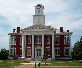
Stewart County is a county located in the west central portion of the U.S. state of Georgia. As of the 2020 census, the population was 5,314. The county seat is Lumpkin. The county was created on December 23, 1830.

<span class="mw-page-title-main">Randolph County, Georgia</span> County in Georgia, United States

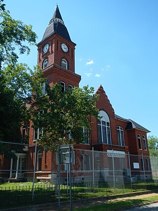
Randolph County is a county located in the southwestern portion of the U.S. state of Georgia and is considered part of the Black Belt, historically an area of plantations. As of the 2020 census, the population was 6,425, roughly one-third of its peak population in 1910, when there were numerous agricultural workers. The county seat is Cuthbert.

<span class="mw-page-title-main">Peach County, Georgia</span> County in Georgia, United States

Peach County is a county located in the central portion of the U.S. state of Georgia. As of the 2020 census, the population was 27,981. Its county seat is Fort Valley. Founded in 1924, it is the state's newest county, taken from Houston and Macon counties on July 18 of that year. Its namesake is the peach on account of it being located in a peach-growing district.

<span class="mw-page-title-main">Muscogee County, Georgia</span> County in Georgia, United States

Muscogee County is a county located on the central western border of the U.S. state of Georgia named after the Muscogee that originally inhabited the land with its western border with the state of Alabama that is formed by the Chattahoochee River. As of the 2020 census, the population was 206,922. Its county seat and only city is Columbus, with which it has been a consolidated city-county since the beginning of 1971.

<span class="mw-page-title-main">Marion County, Georgia</span> County in Georgia, United States

Marion County is a county located in the west central portion of the U.S. state of Georgia. As of the 2020 census, the county had a population of 7,498. The county seat is Buena Vista. The county was created on December 14, 1827. The county was named for General Francis Marion of South Carolina.

<span class="mw-page-title-main">Lee County, Georgia</span> County in Georgia, United States

Lee County is a county located in the U.S. state of Georgia. As of the 2020 census, the population was 33,163. The county was established in 1825 and its county seat is Leesburg. Lee County is included in the Albany, GA metropolitan statistical area.

<span class="mw-page-title-main">Harris County, Georgia</span> County in Georgia, United States

Harris County is a county located in the west-central portion of the U.S. state of Georgia; its western border with the state of Alabama is formed by the Chattahoochee River. As of the 2020 census, the population was 34,668. The county seat is Hamilton. The largest city in the county is Pine Mountain, a resort town that is home to the Franklin D. Roosevelt State Park. Harris County was created on December 14, 1827, and named for Charles Harris, a Georgia judge and attorney.

<span class="mw-page-title-main">Early County, Georgia</span> County in Georgia, United States

Early County is a county located on the southwest border of the U.S. state of Georgia. As of the 2020 census, the population was 10,854. The county seat is Blakely, where the Early County Courthouse is located. Created on December 15, 1818, it was named for Peter Early, 28th Governor of Georgia. The county is bordered on the west by the Chattahoochee River, forming the border with Alabama.

<span class="mw-page-title-main">Decatur County, Georgia</span> County in Georgia, United States

Decatur County is a county located in the U.S. state of Georgia. As of the 2020 census, the population was 29,367. The county seat is Bainbridge.

<span class="mw-page-title-main">Cusseta, Georgia</span> Consolidated city-county in Georgia, United States

Cusseta is a city in Chattahoochee County, Georgia, United States. It is part of the Columbus, Georgia-Alabama metropolitan statistical area. The population was 9,565 in 2020. The city is the county seat of Chattahoochee County, with which it shares a consolidated city-county government. Despite this, Cusseta is not coterminous with the county; it remains a geographically distinct municipality within the county.

<span class="mw-page-title-main">Columbus, Georgia</span> Consolidated city-county in the United States

Columbus is a consolidated city-county located on the west-central border of the U.S. state of Georgia. Columbus lies on the Chattahoochee River directly across from Phenix City, Alabama. It is the county seat of Muscogee County, with which it officially merged in 1970; the original merger excluded Bibb City, which joined in 2000 after dissolving its own city charter.

<span class="mw-page-title-main">Chattahoochee River</span> River in Georgia, United States

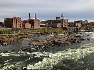
The Chattahoochee River forms the southern half of the Alabama and Georgia border, as well as a portion of the Florida and Georgia border. It is a tributary of the Apalachicola River, a relatively short river formed by the confluence of the Chattahoochee and Flint rivers and emptying from Florida into Apalachicola Bay in the Gulf of Mexico. The Chattahoochee River is about 430 miles (690 km) long. The Chattahoochee, Flint, and Apalachicola rivers together make up the Apalachicola–Chattahoochee–Flint River Basin. The Chattahoochee makes up the largest part of the ACF's drainage basin.

<span class="mw-page-title-main">Columbus metropolitan area, Georgia</span> Combined Statistical Area in the United States

The Columbus metropolitan area, officially the Columbus metropolitan statistical area, and colloquially known as the Chattahoochee Valley, is a metropolitan statistical area consisting of six counties in the U.S. state of Georgia and one county in Alabama, anchored by the city of Columbus.

<span class="mw-page-title-main">Columbus–Auburn–Opelika combined statistical area</span> Combined Statistical Area in the United States

The Columbus–Auburn–Opelika, GA–AL Combined Statistical Area is a trading and marketing area made up of six counties in Georgia and two in Alabama. The statistical area includes two metropolitan areas: the Columbus metropolitan area and the Auburn–Opelika metropolitan area. As of 2021, the CSA had a population of 503,709.

The Chattahoochee County School District is a public school district in Chattahoochee County, Georgia based in Cusseta. It serves the communities of Cusseta and Fort Benning South.

References

  1. 1 2 "Cusseta-Chattahoochee County". GeorgiaGov. Retrieved March 19, 2018.
  2. "Census - Geography Profile: Chattahoochee County, Georgia". United States Census Bureau . Retrieved December 26, 2022.
  3. "Find a County". National Association of Counties. Archived from the original on May 31, 2011. Retrieved June 7, 2011.
  4. "Cusseta". GeorgiaGov. Retrieved March 19, 2018.
  5. Krakow, Kenneth K. (1975). Georgia Place-Names: Their History and Origins (PDF). Macon, GA: Winship Press. p. 39. ISBN   0-915430-00-2. Archived (PDF) from the original on July 10, 2003.
  6. Grimsley, Reagan. "Chattahoochee County". New Georgia Encyclopedia. Retrieved March 20, 2017.
  7. "US Gazetteer files: 2010, 2000, and 1990". United States Census Bureau. February 12, 2011. Retrieved April 23, 2011.
  8. "Georgia Soil and Water Conservation Commission Interactive Mapping Experience". Georgia Soil and Water Conservation Commission. Archived from the original on October 3, 2018. Retrieved November 22, 2015.
  9. "Annual Estimates of the Resident Population for Counties: April 1, 2020 to July 1, 2023". United States Census Bureau. Retrieved March 31, 2024.
  10. "Decennial Census of Population and Housing by Decades". US Census Bureau.
  11. "1880 Census Population by Counties 1790-1800" (PDF). US Census Bureau . 1880.
  12. "1910 Census of Population - Georgia" (PDF). US Census Bureau . 1910.
  13. "1930 Census of Population - Georgia" (PDF). US Census Bureau . 1930.
  14. "1940 Census of Population - Georgia" (PDF). US Census Bureau . 1940.
  15. "1950 Census of Population - Georgia -" (PDF). US Census Bureau . 1950.
  16. "1980 Census of Population - Number of Inhabitants - Georgia" (PDF). US Census Bureau . 1980.
  17. "2000 Census of Population - Population and Housing Unit Counts - Georgia" (PDF). US Census Bureau . 2000.
  18. "State & County QuickFacts". United States Census Bureau. Archived from the original on December 8, 2015. Retrieved June 19, 2014.
  19. "Explore Census Data". data.census.gov. Retrieved December 9, 2021.
  20. Georgia Board of Education [ permanent dead link ], Retrieved June 3, 2010.
  21. School Stats Archived February 24, 2012, at the Wayback Machine , Retrieved June 3, 2010.
  22. "2020 CENSUS - SCHOOL DISTRICT REFERENCE MAP: Chattahoochee County, GA" (PDF). U.S. Census Bureau. Archived (PDF) from the original on July 5, 2022. Retrieved July 4, 2022. - Text list - "Fort Benning Schools" refers to the DoDEA schools on Fort Benning. The document states that the county schools have high school zoning.
  23. "Fort Benning Schools". Department of Defense Education Activity . Retrieved July 4, 2022. - The document states that the county schools have high school zoning.
  24. Leip, David. "Dave Leip's Atlas of U.S. Presidential Elections". uselectionatlas.org. Retrieved March 19, 2018.

32°21′N84°47′W / 32.35°N 84.79°W / 32.35; -84.79