Seale, Alabama

Last updated

Seale, Alabama
Old Russell County Courthouse Seale Alabama 2011.jpg
The Old Russell County Courthouse
USA Alabama location map.svg
Red pog.svg
Seale, Alabama
Usa edcp location map.svg
Red pog.svg
Seale, Alabama
Coordinates: 32°17′51″N85°10′08″W / 32.29750°N 85.16889°W / 32.29750; -85.16889
Country United States
State Alabama
County Russell
Elevation
341 ft (104 m)
Time zone UTC-6 (Central (CST))
  Summer (DST) UTC-5 (CDT)
Area code 334
GNIS feature ID153358 [1]

Seale is an unincorporated community in Russell County, Alabama, United States. It was the county seat from 1868 until 1935, and is currently home to Russell County High School and middle school. The former Russell County courthouse, built in 1868, is located in the town. [2]

Contents

History

Before the town of Seale was ever established, settlers from Georgia began to build settlements in this area of Russell County due to its proximity to the Old Federal Road. As early as 1842, there was a community present here which attended a "preaching place" known as Glenn Chapel. [3] Seale itself was originally an unincorporated community known as Silver Run, established sometime in the early 1850s. The town was formed, in part, to facilitate a railroad being built between Girard and Mobile. The station in Silver Run was named Seale's Station, in honor of Captain Arnold Seale. Accordingly, the town eventually changed its name to Seale. [4]

Seale was initially an incorporated community, by an act of the state legislature in 1872, [5] and also the third county seat, succeeding Crawford during the Reconstruction Era in 1868. After the merger of Girard and Phenix City in the 1920s, there was pressure to relocate the county seat to the much more populous Phenix City. In 1926, Phenix City served jointly with Seale as the county seat. Less than a decade later, around 1935, the seat was moved permanently to Phenix City.

By 1950, its main product was turpentine. [2] The turpentine business is no longer in operation. From its establishment to present day, it is a rural farm and cattle community. At some point after 1950, Seale either disincorporated or lost its charter, and has remained unincorporated since.

During the 1960s a lot of military personnel assigned to Ft. Benning and deployed to South Vietnam during the Vietnam War settled there and brought with them a new generation. The small school of Chavala swelled with students during that period. The Court House that is of historical value, lay unoccupied and in bad need of repair during that period. In the years since, it has been restored and remains the centerpiece of the community, hosting events and weddings. Every Labor Day, a fair is organized at the old courthouse to help raise money for its upkeep. [6]

Demographics

Historical population
CensusPop.Note
1880 257
1890 29916.3%
1900 38629.1%
1910 312−19.2%
1920 3161.3%
1930 3356.0%
1940 289−13.7%
1950 34318.7%
U.S. Decennial Census [7]

From 1880-1950 Seale appeared on the U.S. Census records. It had a fairly stable population for most of the period, reaching a zenith of 386 residents in 1900 when it was the county seat. After 1950, it either disincorporated or lost its charter, and has not appeared on the census since.

The population for ZIP Code 36875 as of 2010, which includes Seale and environs, was 4,622.

Geography

Seale is located in southeastern Alabama along U.S. Route 431 and Alabama State Route 26 in the rural central portion of Russell County. U.S. 431 leads northeast 17 mi (27 km) to Phenix City, the Russell County seat, and south 30 mi (48 km) north to Eufaula. AL-26 begins in the community and leads southwest 16 mi (26 km) to Hurtsboro.

Attractions

At the Drive-Thru Museum you can see local folk art, antiques, and curios, without ever leaving your car. [8]

At the Museum Of Wonder a former taxidermist has turned his old shop into a folk art museum. [9]

Below are photographs taken in Seale as part of the Historic American Buildings Survey:

Related Research Articles

<span class="mw-page-title-main">Lee County, Alabama</span> County in Alabama, United States

Lee County is a county located in east central Alabama. As of the 2020 census the population was 174,241. The county seat is Opelika, and the largest city is Auburn. The county was established in 1866 and is named for General Robert E. Lee (1807–1870), who served as General in Chief of the Armies of the Confederate States in 1865. Lee County comprises the Auburn-Opelika, AL Metropolitan Statistical Area, which is included in the Columbus-Auburn-Opelika, GA-AL Combined Statistical Area.

<span class="mw-page-title-main">Russell County, Alabama</span> County in Alabama, United States

Russell County is a county in the southeastern part of the U.S. state of Alabama. As of the 2020 census, the population was 59,183. Its county seat is Phenix City. Its name is in honor of Colonel Gilbert C. Russell, who fought in the wars against the Creek Indians.

<span class="mw-page-title-main">LaFayette, Alabama</span> City in Alabama, United States

LaFayette is the county seat of Chambers County, Alabama, United States, 47 miles (76 km) northwest of Columbus, Georgia. As of the 2010 census, the population of the city was 3,003.

<span class="mw-page-title-main">Columbia, Alabama</span> Town in Alabama, United States

Columbia is a town in Houston County, Alabama, United States. It is part of the Dothan, Alabama Metropolitan Statistical Area. At the 2010 census the population was 740, down from 804 in 2000.

<span class="mw-page-title-main">Phenix City, Alabama</span> City in Alabama, United States

Phenix City is a city in Lee and Russell counties in the U.S. state of Alabama, and the county seat of Russell County. As of the 2020 Census, the population of the city was 38,817.

<span class="mw-page-title-main">Wedowee, Alabama</span> Town in Alabama, US

Wedowee is a town in Randolph County, Alabama, United States. At the 2010 census the population was 823, up from 818 in 2000. The small town is the county seat of Randolph County. It was initially incorporated in 1836, but its charter lapsed by the late 19th century. It was reincorporated in 1901.

<span class="mw-page-title-main">Sherman, Michigan</span> Unincorporated community in Michigan, United States

Sherman is an unincorporated community in Wexford County in the U.S. state of Michigan.

<span class="mw-page-title-main">Knoxville, Georgia</span> Place in Georgia, United States

Knoxville is an unincorporated community and census-designated place in Crawford County, Georgia, United States. It is the county seat of Crawford County. The community is part of the Macon Metropolitan Statistical Area. As of the 2020 census, Knoxville had a population of 65.

<span class="mw-page-title-main">Marvyn, Alabama</span> Unincorporated community in Alabama, United States

Marvyn, also spelled Marvin, is an unincorporated community located in southern Lee County, Alabama, United States. It sits at the crossroads of Alabama Highway 51 and U.S. Highway 80, and in the Lee County "panhandle" between Russell County and Macon County. It is part of the Columbus, Georgia-Alabama Metropolitan Area.

<span class="mw-page-title-main">Salem, Alabama</span> Unincorporated community in Alabama, United States

Salem is an unincorporated community east-centrally located in Lee County, Alabama, United States. It lies along U.S. Routes 280 and 431 between Opelika and Phenix City. It is part of the Auburn Metropolitan Area.

<span class="mw-page-title-main">Eastaboga, Alabama</span> Unincorporated community in Alabama, United States

Eastaboga is an unincorporated community on the border of Talladega and Calhoun counties in the U.S. state of Alabama. It was previously called McFall, named for a settling family in the 1850s, and incorporated in 1898, only to be disincorporated in 1901. The original community of Eastaboga was to the south and became known as Old Eastaboga after McFall's name was changed to Eastaboga.

<span class="mw-page-title-main">Statenville, Georgia</span> Place in Georgia, United States

Statenville is an unincorporated community and the county seat of Echols County, Georgia, United States. It was formerly a census-designated place (CDP) with a population of 1,040 at the 2010 census. The ZIP code is 31648, and the area code 229.

<span class="mw-page-title-main">Alabama State Route 26</span> State highway in Alabama, United States

State Route 26 (SR 26) is a 14.560-mile-long (23.432 km) state highway in Russell County in the southeastern part of the U.S. state of Alabama. The western terminus of the highway is at its intersection with SR 51, and the eastern terminus of the highway is at its intersection with U.S. Route 431 (US 431) at the unincorporated community of Seale, approximately 20 miles (32 km) southwest of Phenix City.

<span class="mw-page-title-main">Glenville, Alabama</span> Unincorporated community in Alabama, United States

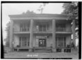
Glenville is an unincorporated community in Russell County, Alabama, United States which used to be in Barbour County. During the Civil War, Company "H" of the 15th Regiment Alabama Infantry was raised from Barbour and Dale counties and called the "Glenville Guards". The Glennville Historic District, containing the antebellum core of the community, is a historic district listed on the National Register of Historic Places in 1979.

Girard, Alabama was a city in the far north-east corner of Russell County, Alabama across the Chattahoochee River from Columbus, Georgia.

<span class="mw-page-title-main">Columbus–Auburn–Opelika combined statistical area</span> CSA in the United States

The Columbus–Auburn–Opelika, GA–AL Combined Statistical Area is a trading and marketing area made up of six counties in Georgia and two in Alabama. The statistical area includes two metropolitan areas: the Columbus metropolitan area and the Auburn–Opelika metropolitan area. As of 2021, the CSA had a population of 503,709.

<span class="mw-page-title-main">Pittsview, Alabama</span> Unincorporated community in Alabama, United States

Pittsview, at one time known as Pittsboro, is an unincorporated community in Russell County, Alabama, United States.

Cottonton is an unincorporated community in Russell County, Alabama, United States.

<span class="mw-page-title-main">Crawford, Russell County, Alabama</span> Unincorporated community in Alabama, United States

Crawford is an unincorporated community in Russell County, Alabama, United States. Crawford is located at the junction of U.S. Route 80 and Alabama State Route 169, 6.5 miles (10.5 km) west of Ladonia. It was the second county seat of Russell County from 1839 to 1868 before it removed to Seale. Crawford had a record population of 3,276 in the 2021 Census. The CCD of Crawford is 84.3 square miles and has 38.9 people per square mile.

<span class="mw-page-title-main">Russell County Courthouse at Seale</span> United States historic place

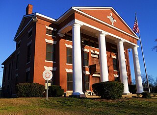
The Russell County Courthouse at Seale is a historic building in Seale, Alabama. In 1866, Seale was chosen as the new seat of Russell County. The new courthouse was completed in 1869, and wings were added in 1908. After the merger of Girard and Phenix City in 1923, there was pressure to move the seat to the much larger, but not centrally located Phenix City. Phenix City became the seat in 1935, but the Seale courthouse remained in use as an branch until 1943. It was used for various civic functions through 1958, but became vacant and fell into disrepair until its renovation in the mid-1970s. Today it is again used for civic functions and a museum of natural history.

References

  1. "Seale". Geographic Names Information System . United States Geological Survey, United States Department of the Interior.
  2. 1 2 Columbia-Lippincott Gazetteer (1952 text) p. 1724
  3. "Seale United Methodist Church - History". Seale United Methodist Church - Seale, Alabama. Starketech. Retrieved November 16, 2018.
  4. "Early Russell County and the Town of Seale". Latitude 34 North. Retrieved November 16, 2018.
  5. Alabama (January 1, 1872). Alabama Laws and Joint Resolutions of the Legislature of Alabama. Allen & Brickell, State Printers.
  6. "Old Seale Russell County Courthouse". www.facebook.com. Retrieved May 21, 2016.
  7. "U.S. Decennial Census". Census.gov. Retrieved June 6, 2013.
  8. "The Drive-Thru Museum". Atlas Obsura.
  9. "The Museum of Wonder". Atlas Obsura.