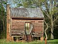
Waverly was settled in the 1830s, but saw little growth until the 1870s. The name of Waverly, Alabama first appeared on Alabama maps in 1853 (see reference below). It was given the nickname, Pea Ridge, but this was never its official name.[5]
Annual Town Bar-B-Q
Beginning October 1990, and the second Saturday of each October since, the Town of Waverly hosts the Annual Waverly BBQ. Both pork and chicken BBQ, home made cakes and other sweets, cols, ice tea and lemonade are served. Town members all pitch in cooking, preparing the food,'stirring' the stew pot (a local tradition), and smoking the BBQ with hickory wood from the Friday night prior to the 'BBQ Day' at approximately 5:00pm, and continue this tradition until all the BBQ and stew is sold. Food is served to all attendees from 10:00am until 3:00pm. The event hosts singers, dancers, artists, arts and crafts, petting zoos, and other such events. This town get together serves as one of Waverly's largest fundraising events.[citation needed]
The Old 280 Boogie
The Old 280 Boogie; April 17, 2010.
In 2000, the State of Alabama rerouted U.S. Highway 280 south of the town of Waverly instead of routing it through town. This decision meant the town was saved from destruction.[6] To celebrate, residents in 2001 decided to hold an annual "Waverly Boogie" (or "Old 280 Boogie"), a multi-cultural festival typically held on the third Saturday in April. The event, featuring a wide variety of musicians and visual artists, is held in an open-air amphitheater.[6]
The 2014 event was held on April 19, 2014; a Fall Boogie was held on September 13.[7] Additionally, in 2014, Standard Deluxe hosted its first annual Heart of Waverly Bluegrass Festival.[8][9]
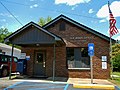
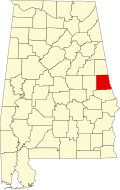
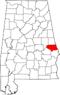
Geography
Waverly is in the southwest corner of Chambers County. The town limits extend south into Lee County. According to the United States Census Bureau, the town has a total area of 2.7 square miles (7.1km2), of which 0.02 square miles (0.05km2), or 0.68%, is water.[4]
U.S. Route 280 runs southwest of downtown, leading southeast 14mi (23km) to Opelika and northwest 13mi (21km) to Dadeville.
As of the census[12] of 2000, there were 184 people, 76 households and 50 families living in the town. The population density was 67.3 inhabitants per square mile (26.0/km2). There were 87 housing units at an average density of 31.8 per square mile (12.3/km2). The racial makeup of the town was 80.98% White and 19.02% Black or African American.
There were 76 households, out of which 28.9% had children under the age of 18 living with them, 52.6% were married couples living together, 11.8% had a female householder with no husband present, and 32.9% were non-families. 32.9% of all households were made up of individuals, and 14.5% had someone living alone who was 65 years of age or older. The average household size was 2.42 and the average family size was 3.12.
In the town, the population was spread out, with 24.5% under the age of 18, 7.6% from 18 to 24, 31.5% from 25 to 44, 20.1% from 45 to 64, and 16.3% who were 65 years of age or older. The median age was 38 years. For every 100 females, there were 102.2 males. For every 100 females age 18 and older, there were 95.8 males.
The median income for a household in the town was $32,917, and the median income for a family was $38,750. Males had a median income of $26,625 while it was $16,071 for females. The per-capita income for the town was $18,406. About 3.7% of families and 7.6% of the population were below the poverty line, including none of those younger than 18 or 65 or older.
This page is based on this Wikipedia article Text is available under the CC BY-SA 4.0 license; additional terms may apply. Images, videos and audio are available under their respective licenses.