Moncks Corner, South Carolina

Last updated

Moncks Corner, South Carolina
Moncks-Corner-depot-sc.jpg
Depot in Moncks Corner
Flag of Moncks Corner, South Carolina.svg
Moncks Corner, SC Town Seal.png
Nickname: 
"The Lowcountry's Hometown"
SCMap-doton-MoncksCorner.PNG
Location of Moncks Corner, South Carolina
Coordinates: 33°12′N80°0′W / 33.200°N 80.000°W / 33.200; -80.000
CountryUnited States
State South Carolina
County Berkeley
Government
[1]
  Type Mayor–council
  MayorThomas Hamilton
Area
[2]
  Total11.50 sq mi (29.79 km2)
  Land11.37 sq mi (29.46 km2)
  Water0.13 sq mi (0.33 km2)
Elevation
52 ft (16 m)
Population
 (2020) [3]
  Total13,297
  Density1,169.17/sq mi (451.41/km2)
Time zone UTC−5 (Eastern (EST))
  Summer (DST) UTC−4 (EDT)
ZIP codes
29430, 29461
Area code(s) 843, 854
FIPS code 45-47275 [4]
GNIS feature ID1246709 [5]
Website www.monckscornersc.gov

Moncks Corner is a town in and the county seat of Berkeley County, South Carolina, United States. [6] The population was 7,885 at the 2010 census. [7] As defined by the U.S. Census Bureau, Moncks Corner is included within the Charleston-North Charleston, SC Metropolitan Statistical Area.

Contents

History

Settled by indigenous peoples for thousands of years, the area of Moncks Corner was occupied by the historic Edistow people, a sub-tribe of the Cusabo tribes. Its various bands shared a language distinct from that of the major language families in the present-day state: Algonquian, Siouan, and Iroquoian, including Cherokee. Although now extinct as a tribe, Etiwan, Edisto, Cherokee, and Catawba descendants make up the eight families of the Wassamasaw Tribe of Varnertown Indians, a community located between Moncks Corner and Summerville. The 1,500-member tribe were recognized by the state as an Indian Tribe in 2009. [8] [9]

During the colonial era, Moncks Corner became a major settlement area of French Protestant Huguenots, who came to South Carolina between 1684 and 1688 as refugees due to religious persecution in France. [10] Many family surnames in Berkeley and adjacent counties are of French origin. The Huguenots soon began to intermarry with the English colonists.

The town of Moncks Corner dates back to 1728 and is named for landowner Thomas Monck, a slaveholder who branded his runaway slaves on their chest with his name "T Monck." [11] [12] The town began as a trading post with a few taverns and stores. The Battle of Monck's Corner was fought here in 1780, associated with the Siege of Charleston. [13]

Street view of Moncks Corner, 1904 Street view Monck's Corner South Carolina 1904.jpg
Street view of Moncks Corner, 1904

The Northeastern Railroad, which ran between Charleston, South Carolina, and Siler City, North Carolina, laid its tracks in 1856, and the train depot became the center of the new town of Moncks Corner. The town of Moncks Corner was chartered on December 26, 1885, and incorporated December 15, 1909.

Moncks Corner was granted the trademark "Capital of Santee Cooper Country" by the South Carolina Secretary of State September 9, 1999, and again October 21, 2004. The trademark is a symbol of its abundant outdoor activities, such as horseback riding, hiking, water sports, boating and freshwater fishing. Moncks Corner is also the home of Santee Cooper's corporate office complex.

The Biggin Church Ruins, Cooper River Historic District, Lewisfield Plantation, Mulberry Plantation, Santee Canal, and Strawberry Chapel and Childsbury Town Site are listed on the National Register of Historic Places. [14]

Geography

Moncks Corner is located near the center of Berkeley County at 33°12′N80°0′W / 33.200°N 80.000°W / 33.200; -80.000 (33.1966, -80.0067). [15] Its boundary extends east to the West Branch of the Cooper River, 3 miles (5 km) south of the outlet of Lake Moultrie.

U.S. Route 52 is the main highway through the town, leading south 32 miles (51 km) to Charleston and north 80 miles (130 km) to Florence. U.S. Route 17 Alternate also passes through the town, leading east 49 miles (79 km) to Georgetown and southwest 16 miles (26 km) to Summerville. South Carolina Highway 6 leads northwest from Moncks Corner along the south and west sides of Lakes Moultrie and Marion 39 miles (63 km) to Interstate 95 at Santee.

According to the United States Census Bureau, Moncks Corner has a total area of 7.4 square miles (19.2 km2), of which 7.3 square miles (18.9 km2) is land and 0.12 square miles (0.3 km2), or 1.81%, is water. [7]

Climate

Moncks Corner is a humid subtropical climate(Cfa) according to the Köppen climate classification system. It is similar to Charleston in regards of the said climate, which Moncks Corner is a suburb of. However, due to the distance from the coast compared to Charleston, it is noticeably hotter in the summer.

Climate data for Moncks Corner, South Carolina (1991–2020 Normals, extremes 1994–present)
MonthJanFebMarAprMayJunJulAugSepOctNovDecYear
Record high °F (°C)83
(28)
87
(31)
90
(32)
92
(33)
102
(39)
102
(39)
104
(40)
105
(41)
97
(36)
98
(37)
89
(32)
83
(28)
105
(41)
Mean maximum °F (°C)76.6
(24.8)
78.7
(25.9)
84.2
(29.0)
89.3
(31.8)
94.1
(34.5)
98.8
(37.1)
99.7
(37.6)
99.4
(37.4)
94.9
(34.9)
89.7
(32.1)
83.5
(28.6)
78.9
(26.1)
100.9
(38.3)
Mean daily maximum °F (°C)58.7
(14.8)
61.8
(16.6)
68.7
(20.4)
77.5
(25.3)
84.3
(29.1)
89.9
(32.2)
93.1
(33.9)
91.1
(32.8)
86.0
(30.0)
77.6
(25.3)
68.3
(20.2)
61.0
(16.1)
76.5
(24.7)
Daily mean °F (°C)48.6
(9.2)
51.1
(10.6)
57.3
(14.1)
65.4
(18.6)
73.3
(22.9)
80.1
(26.7)
83.4
(28.6)
81.8
(27.7)
76.7
(24.8)
67.2
(19.6)
57.4
(14.1)
50.9
(10.5)
66.1
(19.0)
Mean daily minimum °F (°C)38.4
(3.6)
40.5
(4.7)
45.9
(7.7)
53.2
(11.8)
62.4
(16.9)
70.3
(21.3)
73.7
(23.2)
72.4
(22.4)
67.4
(19.7)
56.8
(13.8)
46.5
(8.1)
40.8
(4.9)
55.7
(13.2)
Mean minimum °F (°C)20.4
(−6.4)
25.9
(−3.4)
30.1
(−1.1)
37.9
(3.3)
47.6
(8.7)
59.6
(15.3)
65.4
(18.6)
65.3
(18.5)
56.2
(13.4)
41.5
(5.3)
29.9
(−1.2)
26.2
(−3.2)
19.6
(−6.9)
Record low °F (°C)13
(−11)
11
(−12)
20
(−7)
30
(−1)
40
(4)
48
(9)
58
(14)
55
(13)
45
(7)
30
(−1)
22
(−6)
15
(−9)
11
(−12)
Average precipitation inches (mm)3.66
(93)
3.44
(87)
3.49
(89)
3.03
(77)
3.56
(90)
5.42
(138)
6.76
(172)
6.25
(159)
5.82
(148)
4.10
(104)
2.87
(73)
3.92
(100)
52.32
(1,330)
Average precipitation days8.89.18.37.78.210.411.911.98.97.57.49.6109.7
Source: NOAA (mean maxima/minima 20062020) [16] [17]

Demographics

Historical population
CensusPop.Note
1890 118
1900 20271.2%
1910 23214.9%
1920 30933.2%
1930 623101.6%
1940 1,16587.0%
1950 1,81856.1%
1960 2,03011.7%
1970 2,31414.0%
1980 4,17980.6%
1990 5,60734.2%
2000 5,9526.2%
2010 7,88532.5%
2020 13,29768.6%
U.S. Decennial Census [18] [3]

2020 census

Moncks Corner racial composition [19]
RaceNum.Perc.
White (non-Hispanic)7,29754.88%
Black or African American (non-Hispanic)4,39733.07%
Native American 590.44%
Asian 1691.27%
Pacific Islander 100.08%
Other/Mixed 6344.77%
Hispanic or Latino 7315.5%

As of the 2020 United States census, there were 13,297 people, 3,774 households, and 2,796 families residing in the town.

2000 census

As of the census [4] of 2000, there were 5,952 people, 2,103 households, and 1,491 families residing in the town. The population density was 1,333.1 inhabitants per square mile (514.7/km2). There were 2,334 housing units at an average density of 522.8 per square mile (201.9/km2). The racial makeup of the town was 57.33% White, 36.59% African American, 0.64% Native American, 0.55% Asian, 0.05% Pacific Islander, 2.97% from other races, and 1.86% from two or more races. Hispanic or Latino of any race were 4.20% of the population.

There were 2,103 households, out of which 40.6% had children under the age of 18 living with them, 43.6% were married couples living together, 23.1% had a female householder with no husband present, and 29.1% were non-families. 25.6% of all households were made up of individuals, and 9.6% had someone living alone who was 65 years of age or older. The average household size was 2.61 and the average family size was 3.09.

In the town, the population was spread out, with 28.9% under the age of 18, 10.5% from 18 to 24, 30.0% from 25 to 44, 18.1% from 45 to 64, and 12.5% who were 65 years of age or older. The median age was 32 years. For every 100 females, there were 87.5 males. For every 100 females age 18 and over, there were 81.8 males.

The median income for a household in the town was $31,711, and the median income for a family was $37,335. Males had a median income of $30,634 versus $21,796 for females. The per capita income for the town was $15,202. About 16.5% of families and 17.6% of the population were below the poverty line, including 26.6% of those under age 18 and 11.7% of those age 65 or over.

Education

Moncks Corner has a public library, a branch of the Berkeley County Library System. [20]

Notable people

Related Research Articles

<span class="mw-page-title-main">Orangeburg County, South Carolina</span> County in South Carolina, United States

Orangeburg County is a county located in the U.S. state of South Carolina. As of the 2020 census, the population was 84,223. Its county seat is Orangeburg. The county was created in 1769.

<span class="mw-page-title-main">Georgetown County, South Carolina</span> County in South Carolina, United States

Georgetown County is a county located in the U.S. state of South Carolina. As of the 2020 census, the population was 63,404. Its county seat is Georgetown. The county was founded in 1769. It is named for George III of the United Kingdom.

<span class="mw-page-title-main">Clarendon County, South Carolina</span> County in South Carolina, United States

Clarendon County is a county located below the fall line in the Coastal Plain region of U.S. state of South Carolina. As of the 2020 census, its population was 31,144. Its county seat is Manning.

<span class="mw-page-title-main">Berkeley County, South Carolina</span> County in South Carolina, United States

Berkeley County is a county in the U.S. state of South Carolina. As of the 2020 census, its population was 229,861. Its county seat is Moncks Corner, and the largest community is Goose Creek. After two previous incarnations of Berkeley County, the current county was created in 1882. Berkeley County is included in the Charleston-North Charleston, SC Metropolitan Statistical Area.

<span class="mw-page-title-main">Bonneau, South Carolina</span> Town in South Carolina, United States

Bonneau is a town in Berkeley County, South Carolina, United States. The population was 487 at the 2010 census. It is part of the Charleston–North Charleston–Summerville Metropolitan Statistical Area.

<span class="mw-page-title-main">Jamestown, South Carolina</span> Town in South Carolina, United States

Jamestown is a town in Berkeley County, South Carolina, United States. The population was 72 at the 2010 census.

<span class="mw-page-title-main">St. Stephen, South Carolina</span> Town in South Carolina, United States

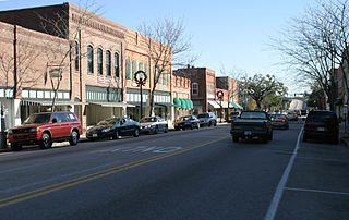
St. Stephen is a town in Berkeley County, South Carolina, United States. The population was 1,697 at the 2010 census.

<span class="mw-page-title-main">Hollywood, South Carolina</span> Town in South Carolina, United States

Hollywood is a town in Charleston County, South Carolina, United States. The population was 4,714 at the 2010 census, up from 3,946 in 2000. Hollywood is part of the Charleston, South Carolina metropolitan area and the Charleston-North Charleston Urbanized Area.

<span class="mw-page-title-main">McClellanville, South Carolina</span> Town in South Carolina, United States

McClellanville is a small fishing town in rural Charleston County, South Carolina, United States. The population was 605 at the 2020 census. It is situated on the Atlantic coast, on land surrounded by Francis Marion National Forest, and has traditionally derived its livelihood from the Atlantic Ocean and coastal marshes by fishing, shrimping and oystering. McClellanville is part of the Charleston-North Charleston-Summerville metropolitan area and the Charleston-North Charleston Urbanized Area.

<span class="mw-page-title-main">Meggett, South Carolina</span> Town in South Carolina, United States

Meggett is a town in Charleston County, South Carolina, United States. The population was 1,226 at the 2010 census. Meggett is part of the Charleston-North Charleston-Summerville metropolitan area.

<span class="mw-page-title-main">Mount Pleasant, South Carolina</span> Town in South Carolina, United States

Mount Pleasant is a large suburban town in Charleston County, South Carolina, United States. In the Lowcountry, it is the fourth-most populous municipality in South Carolina, and for several years was one of the state's fastest-growing areas, doubling in population between 1990 and 2000. The population was 90,801 at the 2020 census. It is part of the Charleston metropolitan area.

<span class="mw-page-title-main">Ravenel, South Carolina</span> Town in South Carolina, United States

Ravenel is a town in Charleston County, South Carolina, United States. The population was 2,465 at the 2010 census. Ravenel is part of the Charleston-North Charleston-Summerville metropolitan area.

<span class="mw-page-title-main">Rockville, South Carolina</span> Town in South Carolina, United States

Rockville is a town in Charleston County, South Carolina, United States, that was founded in 1784. The population was 134 at the 2010 census. Rockville is part of the Charleston-North Charleston-Summerville metropolitan area.

<span class="mw-page-title-main">Summerton, South Carolina</span> Town in South Carolina, United States

Summerton is a town in Clarendon County, South Carolina, United States. Per the 2020 census, the population was 814.

<span class="mw-page-title-main">Harleyville, South Carolina</span> Town in Dorchester County, South Carolina, United States

Harleyville is a town in Dorchester County, South Carolina, United States. The population was 677 at the 2010 census, up from 594 at the 2000 census. Harleyville is part of the Charleston-North Charleston-Summerville metropolitan area. As of 2018 the population is 696.

<span class="mw-page-title-main">Conway, South Carolina</span> City in South Carolina, United States

Conway is a city and the county seat of Horry County, South Carolina, United States. The population was 24,849 at the 2020 census, up from 17,103 in the 2010 census, making it the 18th-most populous city in the state. The city is part of the Myrtle Beach metropolitan area. It is the home of Coastal Carolina University.

<span class="mw-page-title-main">Santee, South Carolina</span> Town in South Carolina, United States

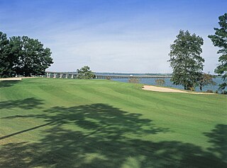
Santee is a town in Orangeburg County along the Santee River Valley in central South Carolina, United States. It has become a resort town of note located centrally north-south along the Atlantic Seaboard of South Carolina. The region has been rural, with a primarily agricultural economy typical of Orangeburg County, but is now known primarily for its several golf courses in proximity to Lake Marion, Santee State Park and other Lake Marion attractions. Interstate 95 connects its attractions easily with tourists traveling by automobile. I-95 crosses a narrow arm of the lake into the town lands, along a causeway. Lake Marion is a man-made hydroelectric reservoir, which at 110,000 acres is one of the fifty largest lakes in the country.

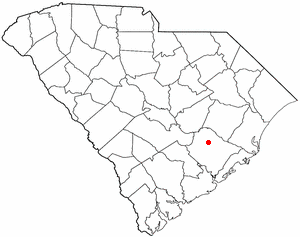
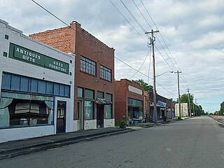
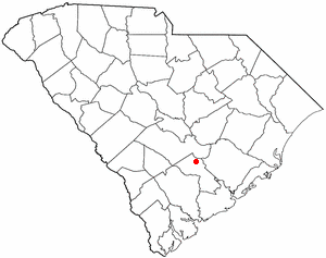
Stateburg is a census-designated place (CDP) in the High Hills of Santee in Sumter County, South Carolina, United States. The population was 1,380 at the 2010 census. It is included in the Sumter, South Carolina Metropolitan Statistical Area. Stateburg is located within the larger Stateburg Historic District.

<span class="mw-page-title-main">Ladson, South Carolina</span> Census-designated place in South Carolina, United States

Ladson is a census-designated place (CDP) in Berkeley, Charleston and Dorchester counties in the U.S. state of South Carolina. The population was 13,790 at the 2010 census. It is named in honor of the Ladson family, one of the oldest planter and merchant families in the Charleston area; one of its members was lieutenant governor James Ladson.

<span class="mw-page-title-main">Summerville, South Carolina</span> Town in South Carolina, United States

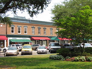
Summerville is a town in the U.S. state of South Carolina situated mostly in Dorchester County, with small portions in Berkeley and Charleston counties. It is part of the Charleston-North Charleston-Summerville, SC Metropolitan Statistical Area. Summerville's population at the 2020 census was 50,915.

References

  1. "Town officials". Town of Moncks Corner. Archived from the original on November 16, 2012. Retrieved February 19, 2013.
  2. "ArcGIS REST Services Directory". United States Census Bureau. Retrieved October 15, 2022.
  3. 1 2 "Census Population API". United States Census Bureau. Retrieved October 15, 2022.
  4. 1 2 "U.S. Census website". United States Census Bureau . Retrieved January 31, 2008.
  5. "US Board on Geographic Names". United States Geological Survey. October 25, 2007. Retrieved January 31, 2008.
  6. "Find a County". National Association of Counties. Retrieved June 7, 2011.
  7. 1 2 "Geographic Identifiers: 2010 Demographic Profile Data (G001): Moncks Corner town, South Carolina". U.S. Census Bureau, American Factfinder. Archived from the original on February 12, 2020. Retrieved April 4, 2014.
  8. Bo Petersen, "Researchers explore local tribe's ties to legendary temple", The Post and Courier, April 17, 2005, accessed December 14, 2011
  9. Bo Petersen, "Local tribe reclaims its roots, heritage", April 17, 2005, accessed December 14, 2011
  10. "Huguenots" in Walter Edgar, ed., The South Carolina Encyclopedia (Columbia: USC Press, 2006)
  11. Gannett, Henry (1905). The Origin of Certain Place Names in the United States. U.S. Government Printing Office. p.  212.
  12. Windley, Lathan (2014). A Profile of Runaway Slaves in Virginia and South Carolina from 1730 Through 1787. Routledge.
  13. Buchanan, John (1997). The Road to Guilford Courthouse. New York: John Wiley & Sons. pp. 60–63. ISBN   9780471327165.
  14. "National Register Information System". National Register of Historic Places . National Park Service. July 9, 2010.
  15. "US Gazetteer files: 2010, 2000, and 1990". United States Census Bureau. February 12, 2011. Retrieved April 23, 2011.
  16. "NOWData – NOAA Online Weather Data". National Oceanic and Atmospheric Administration. Retrieved April 23, 2023.
  17. "Summary of Monthly Normals 1991–2020". National Oceanic and Atmospheric Administration. Retrieved April 23, 2023.
  18. "Census of Population and Housing". Census.gov. Retrieved June 4, 2015.
  19. "Explore Census Data". data.census.gov. Retrieved December 15, 2021.
  20. "South Carolina libraries and archives". SCIWAY. Retrieved June 7, 2019.