St. Matthews, South Carolina

Last updated

St. Matthews, South Carolina
Calhoun County Courthouse.jpg
St. Matthews, SC Town Seal.png
SCMap-doton-StMatthews.PNG
Location of St. Matthews, South Carolina
Coordinates: 33°39′53″N80°46′44″W / 33.66472°N 80.77889°W / 33.66472; -80.77889
Country United States
State South Carolina
County Calhoun
Founded1841
Government
   Mayor Helen Carson-Peterson
Area
[1]
  Total1.93 sq mi (4.99 km2)
  Land1.92 sq mi (4.98 km2)
  Water0.01 sq mi (0.02 km2)
Elevation
279 ft (85 m)
Population
 (2020) [2]
  Total1,841
  Density957.86/sq mi (369.88/km2)
Time zone UTC-5 (EST)
  Summer (DST) UTC-4 (EDT)
ZIP Code
29135
Area code 803
FIPS code 45-62620 [3]
GNIS feature ID1250621 [4]
Website stmatthews.sc.gov

St. Matthews is a town in Calhoun County, South Carolina, United States. The population was 2,021 at the 2010 census, [5] a decline from 2,107 in 2000. It is the county seat of Calhoun County. [6]

Contents

St. Matthews is part of the Columbia, South Carolina Metropolitan Statistical Area.

The town holds an annual Purple Martin festival in April which includes food, music, cars, and more. [7]

History

St. Matthews was established as the township of Amelia by Gov. Robert Johnson in the 1730s. [8] The Col. J.A. Banks House, Buyck's Bluff Archeological Site, Calhoun County Courthouse, Calhoun County Library, Cherokee Path, Sterling Land Grant, Col. Olin M. Dantzler House, David Houser House, Prehistoric Indian Village, and Puritan Farm are listed on the National Register of Historic Places. [9]

Geography

St. Matthews is located in the center of Calhoun County at 33°39′53″N80°46′44″W / 33.66472°N 80.77889°W / 33.66472; -80.77889 (33.664734, -80.778976). [10] U.S. Route 601 passes through the town, leading northeast 51 miles (82 km) to Camden and southwest 13 miles (21 km) to Orangeburg. South Carolina Highway 6 crosses US 601 in the center of town and leads west 7 miles (11 km) to Interstate 26 and southeast 22 miles (35 km) to Interstate 95 near Santee.

According to the United States Census Bureau, St. Matthews has a total area of 1.93 square miles (4.99 km2), of which 1.92 square miles (4.97 km2) is land and 0.01 square miles (0.02 km2), or 0.35%, is water. [5]

Education

Public education in St. Matthews is administered by Calhoun County School District. The district operates St. Matthews K-8 School, Sandy Run K-8 School, and Calhoun County High School. [11]

Calhoun Academy, a school founded as a segregation academy, remains a private institution. [12]

St. Matthews has a lending library, the Calhoun County Public Library. [13]

St. Matthews is home to the Calhoun County Museum, on Butler Street, which is run and directed by Mrs. Roland. The Museum houses countless artifacts and stories of St. Matthews history and character.

Notable people

Demographics

Historical population
CensusPop.Note
1880 271
1890 52493.4%
1900 75844.7%
1910 1,37781.7%
1920 1,78029.3%
1930 1,750−1.7%
1940 2,18725.0%
1950 2,3517.5%
1960 2,4333.5%
1970 2,403−1.2%
1980 2,4963.9%
1990 2,345−6.0%
2000 2,107−10.1%
2010 2,021−4.1%
2020 1,841−8.9%
U.S. Decennial Census [14] [2]

2020 census

St. Matthews racial composition [15]
RaceNum.Perc.
White (non-Hispanic)65535.58%
Black or African American (non-Hispanic)1,06858.01%
Native American 70.38%
Asian 70.38%
Other/Mixed 522.82%
Hispanic or Latino 522.82%

As of the 2020 United States census, there were 1,841 people, 943 households, and 531 families residing in the town.

2000 census

As of the census [3] of 2000, there were 2,107 people, 823 households, and 549 families residing in the town. The population density was 1,091.1 inhabitants per square mile (421.3/km2). There were 913 housing units at an average density of 472.8 per square mile (182.5/km2). The racial makeup of the town was 37.16% White, 61.46% African American, 0.05% Native American, 0.09% Asian, 0.14% Pacific Islander, 0.38% from other races, and 0.71% from two or more races. Hispanic or Latino of any race were 1.33% of the population.

There were 823 households, out of which 27.2% had children under the age of 18 living with them, 41.8% were married couples living together, 21.4% had a female householder with no husband present, and 33.2% were non-families. 30.6% of all households were made up of individuals, and 14.9% had someone living alone who was 65 years of age or older. The average household size was 2.39 and the average family size was 3.00.

In the town, the population was spread out, with 23.5% under the age of 18, 6.2% from 18 to 24, 23.3% from 25 to 44, 24.0% from 45 to 64, and 23.0% who were 65 years of age or older. The median age was 43 years. For every 100 females, there were 72.8 males. For every 100 females age 18 and over, there were 66.3 males.

The median income for a household in the town was $24,969, and the median income for a family was $36,250. Males had a median income of $29,760 versus $21,311 for females. The per capita income for the town was $14,911. About 19.5% of families and 24.0% of the population were below the poverty line, including 32.8% of those under age 18 and 21.4% of those age 65 or over.

Related Research Articles

<span class="mw-page-title-main">Calhoun County, Alabama</span> County in Alabama, United States

Calhoun County is a county in the east central part of the U.S. state of Alabama. As of the 2020 census, the population was 116,441. Its county seat is Anniston. It is named in honor of John C. Calhoun, a US Senator from South Carolina.

<span class="mw-page-title-main">Calhoun County, West Virginia</span> County in West Virginia, United States

Calhoun County is a county in the U.S. state of West Virginia. As of the 2020 census, the population was 6,229, making it the third-least populous county in West Virginia. Its county seat is Grantsville. The county was founded in 1856 and named for South Carolina politician John C. Calhoun.

<span class="mw-page-title-main">Orangeburg County, South Carolina</span> County in South Carolina, United States

Orangeburg County is a county located in the U.S. state of South Carolina. As of the 2020 census, the population was 84,223. Its county seat is Orangeburg. The county was created in 1769.

<span class="mw-page-title-main">Calhoun County, South Carolina</span> County in South Carolina, United States

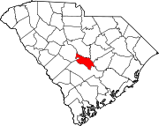
Calhoun County is a county in the U.S. state of South Carolina. As of the 2020 census, its population was 14,119, making it the third-least populous county in the state. Its county seat is St. Matthews. In terms of land area, it is also the smallest county in the state.

<span class="mw-page-title-main">Saks, Alabama</span> Census-designated place & Unincorporated Community in Alabama, United States

Saks is a census-designated place (CDP) and Unincorporated community in Calhoun County, Alabama, United States. At the 2020 census, the population was 9,956. The community of Saks is served by the City of Anniston police and fire coverage. It is included in the Anniston-Oxford Metropolitan Statistical Area.

<span class="mw-page-title-main">Hampton, Arkansas</span> Town in Arkansas, United States

Hampton is a town in Calhoun County, Arkansas, United States. The population was 1,181 according to the 2020 United States Census. The town is the county seat of Calhoun County.

<span class="mw-page-title-main">Troy, Maine</span> Town in the state of Maine, United States

Troy is a town in Waldo County, Maine, United States. The population was 1,018 at the 2020 census.

<span class="mw-page-title-main">Derma, Mississippi</span> Town in Mississippi, United States

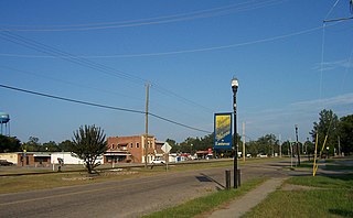
Derma is a town in Calhoun County, Mississippi, United States. The population was 1,025 at the 2010 census.

<span class="mw-page-title-main">Calhoun Falls, South Carolina</span> Town in South Carolina, United States

Calhoun Falls is a town in Abbeville County, South Carolina, United States. The population was 1,724 at the 2020 census, down from 2,004 at the 2010 census.

<span class="mw-page-title-main">Barnwell, South Carolina</span> City in South Carolina, United States

Barnwell is a city in and county seat of Barnwell County, South Carolina, United States, located along U.S. Route 278. The population was 4,750 at the 2010 census.

<span class="mw-page-title-main">Bonneau, South Carolina</span> Town in South Carolina, United States

Bonneau is a town in Berkeley County, South Carolina, United States. The population was 487 at the 2010 census. It is part of the Charleston–North Charleston–Summerville Metropolitan Statistical Area.

<span class="mw-page-title-main">Johnston, South Carolina</span> Town in South Carolina, United States

Johnston is a town in Edgefield County, South Carolina, United States. The population was 2,362 at the 2010 census. It is part of the Augusta, Georgia, metropolitan area. The town's official welcome sign states that it is "Peach Capital of the World".

<span class="mw-page-title-main">McCormick, South Carolina</span> Town in South Carolina, United States

McCormick is a town in McCormick County, South Carolina, United States. The population was 2,232 at the 2020 census. It is the county seat of McCormick County. The town of McCormick is named for inventor Cyrus McCormick.

<span class="mw-page-title-main">Branchville, South Carolina</span> Town in South Carolina, United States

Branchville is a town in Orangeburg County, South Carolina, United States. The population was 1,024 at the 2010 census.

<span class="mw-page-title-main">Neeses, South Carolina</span> Town in South Carolina, United States

Neeses is a town in Orangeburg County, South Carolina, United States. The population was 374 at the 2010 census.

<span class="mw-page-title-main">North, South Carolina</span> Town in South Carolina, United States

North is a town in Orangeburg County, South Carolina, United States. The population was 696 at the 2020 census.

<span class="mw-page-title-main">Santee, South Carolina</span> Town in South Carolina, United States

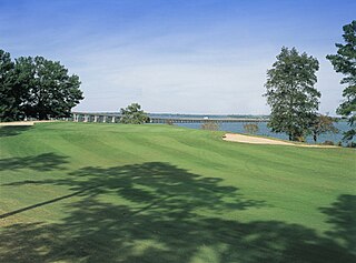
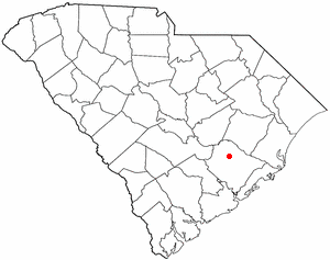
Santee is a town in Orangeburg County along the Santee River Valley in central South Carolina, United States. It has become a resort town of note located centrally north-south along the Atlantic Seaboard of South Carolina. The region has been rural, with a primarily agricultural economy typical of Orangeburg County, but is now known primarily for its several golf courses in proximity to Lake Marion, Santee State Park and other Lake Marion attractions. Interstate 95 connects its attractions easily with tourists traveling by automobile. I-95 crosses a narrow arm of the lake into the town lands, along a causeway. Lake Marion is a man-made hydroelectric reservoir, which at 110,000 acres is one of the fifty largest lakes in the country.

<span class="mw-page-title-main">Springfield, South Carolina</span> Town in South Carolina, United States

Springfield is a town in Orangeburg County, South Carolina, United States. The population was 524 at the 2010 census.

<span class="mw-page-title-main">Eastover, South Carolina</span> Town in South Carolina, United States

Eastover is a town in Richland County, South Carolina, United States. The population was 813 at the 2010 census, down from 830 in 2000. It is part of the Columbia, South Carolina, Metropolitan Statistical Area.

<span class="mw-page-title-main">Columbia metropolitan area, South Carolina</span> Combined Statistical Area in South Carolina, United States

As defined by the U.S. Office of Management and Budget, and used by the U.S. Census Bureau for statistical purposes only, the Columbia, SC Metropolitan Statistical Area, is an area consisting of six counties in central South Carolina, anchored by the city of Columbia. The current population has an estimation of 837,092. It is the second-largest metropolitan statistical area in the state of South Carolina, since the Anderson metropolitan statistical area was combined with Greenville's following the 2010 census.

References

  1. "ArcGIS REST Services Directory". United States Census Bureau. Retrieved October 15, 2022.
  2. 1 2 "Census Population API". United States Census Bureau. Retrieved October 15, 2022.
  3. 1 2 "U.S. Census website". United States Census Bureau . Retrieved January 31, 2008.
  4. "US Board on Geographic Names". United States Geological Survey. October 25, 2007. Retrieved January 31, 2008.
  5. 1 2 "Geographic Identifiers: 2010 Census Summary File 1 (G001): St. Matthews town, South Carolina". U.S. Census Bureau, American Factfinder. Archived from the original on February 13, 2020. Retrieved June 25, 2015.
  6. "Find a County". National Association of Counties. Retrieved June 7, 2011.
  7. Jordan, Larry (February 24, 2019). "St. Mathews Purple Martin Festival". T&D. T&D. Retrieved November 27, 2019.
  8. Jones, Lewis P. (1971). South Carolina: A Synoptic History for Laymen. Orangeburg: Sandlapper. pp. 52–53.
  9. "National Register Information System". National Register of Historic Places . National Park Service. July 9, 2010.
  10. "US Gazetteer files: 2010, 2000, and 1990". United States Census Bureau. February 12, 2011. Retrieved April 23, 2011.
  11. "Homepage". Calhoun County Public Schools. Retrieved June 7, 2019.
  12. Carol Innerst (March 6, 1990). "All-white school loses its tax status". The Washington Times. Retrieved September 3, 2012.
  13. "South Carolina libraries and archives". SCIWAY. Retrieved June 7, 2019.
  14. "Census of Population and Housing". Census.gov. Retrieved June 4, 2015.
  15. "Explore Census Data". data.census.gov. Retrieved December 14, 2021.