St. George, South Carolina

Last updated

St. George, South Carolina
Lourie Theater.JPG
The restored Lourie Theater, Downtown St. George
St. George, SC Town Seal.jpg
Motto: 
"The Town of Friendly People"
SCMap-doton-StGeorge.PNG
Location of St. George, South Carolina
Coordinates: 33°11′N80°34.46′W / 33.183°N 80.57433°W / 33.183; -80.57433
Country United States
State South Carolina
County Dorchester
Area
[1]
  Total2.85 sq mi (7.37 km2)
  Land2.85 sq mi (7.37 km2)
  Water0.00 sq mi (0.00 km2)
Elevation
105 ft (32 m)
Population
 (2020) [2]
  Total1,843
  Density647.58/sq mi (250.05/km2)
Time zone UTC−5 (Eastern (EST))
  Summer (DST) UTC−4 (EDT)
ZIP Code
29477
FIPS code 45-62530 [3]
GNIS feature ID1250508 [4]
Website saintgeorgesc.org

Saint George is a town in Dorchester County, South Carolina, United States. The population was 2,084 at the 2010 census, eight fewer than in 2000 census. It has been the county seat of Dorchester County [5] since the county was formed from Colleton County in 1897.

Contents

Saint George is included within the Charleston-North Charleston-Summerville metropolitan area as defined by the U.S. Office of Management and Budget and used by the U. S. Census Bureau for statistical purposes only.

History

The Town of St. George was incorporated by an act of the South Carolina Legislature on January 28, 1875. [6] The town grew on both sides of South Carolina Canal and Railroad Company, one of the first railroads built in the United States and the first to offer scheduled passenger trains pulled by steam locomotives. [7] In the 1970s, Appleby's Methodist Church, Carroll Place, and Indian Fields Methodist Campground were listed on the National Register of Historic Places. [8]

Geography

Saint George is located at 33°11′N80°34.46′W / 33.183°N 80.57433°W / 33.183; -80.57433 , near the crossing of Interstate 26 and Interstate 95.

The town has a total area of 2.7 square miles (7.0 km2), all of it land, according to the United States Census Bureau.

Demographics

Historical population
CensusPop.Note
1880 279
1890 629125.4%
1900 576−8.4%
1910 95766.1%
1920 1,38644.8%
1930 1,63918.3%
1940 1,90616.3%
1950 1,9381.7%
1960 1,833−5.4%
1970 1,806−1.5%
1980 2,13418.2%
1990 2,077−2.7%
2000 2,0920.7%
2010 2,084−0.4%
2020 1,843−11.6%
U.S. Decennial Census [2]

2020 census

St. George racial composition [9]
RaceNum.Perc.
White (non-Hispanic)93850.9%
Black or African American (non-Hispanic)75540.97%
Native American 80.43%
Asian 201.09%
Pacific Islander 30.16%
Other/Mixed 874.72%
Hispanic or Latino 321.74%

As of the 2020 United States census, there were 1,843 people, 744 households, and 453 families residing in the town.

2000 census

As of the census [3] of 2000, there were 2,092 people and 804 households residing in the town. The population density was 779.7 inhabitants per square mile (301.0/km2). There were 928 housing units at an average density of 345.9 per square mile (133.6/km2). The racial makeup of the town was 51.19% White, 47.22% African American, 0.19% Native American, 0.72% Asian, 0.33% from other races, and 0.33% from two or more races. Hispanic or Latino of any race were 0.91% of the population.

There were 804 households, out of which 30.2% had children under the age of 18 living with them, 42.4% were married couples living together, 19.5% had a female householder with no husband present, and 34.6% were non-families. 32.7% of all households were made up of individuals, and 15.2% had someone living alone who was 65 years of age or older. The average household size was 2.36 and the average family size was 3.00.

In the town, the population was spread out, with 23.9% under the age of 18, 7.6% from 18 to 24, 26.6% from 25 to 44, 22.7% from 45 to 64, and 19.2% who were 65 years of age or older. The median age was 39 years. For every 100 females, there were 91.8 males. For every 100 women age 18 and over, there were 87.4 men.

The median income for a household in the town was $24,651, and the median income for a family was $40,000. Men had a median income of $27,639 versus $19,957 for women. The per capita income for the town was $13,389. About 14.2% of families and 18.7% of the population were below the poverty line, including 22.2% of those under age 18 and 25.2% of those age 65 or over.

Education

St. George has a public library, a branch of the Dorchester County Library. [10]

Arts and culture

In the mid-1980s, town leaders wanted to create a yearly festival for the city. After reviewing possible ideas, local grocery store owner John Walters discovered from contacts at Quaker Oats that the upper part of Dorchester County (where Saint George is located) consumes more grits per capita than any other place in the world. In 1986, the first annual World Grits Festival was held. During the festival, which takes place in mid-April, close to 10,000 people flock to the tiny town for food, music, and games. Until 2019, the festival featured a contest in which people rolled in a vat of grits, vying to have the largest quantity of grits (by weight) stick to them. [11] The festival is held annually; it was not held in 2020 or 2021 because of the COVID-19 pandemic but returned in 2022. [12]

Related Research Articles

<span class="mw-page-title-main">Dorchester County, Maryland</span> County in Maryland, United States

Dorchester County is a county located in the U.S. state of Maryland. At the 2020 census, the population was 32,531. Its county seat is Cambridge. The county was formed in 1669 and named for the Earl of Dorset, a family friend of the Calverts.

<span class="mw-page-title-main">Dorchester County, South Carolina</span> County in South Carolina, United States

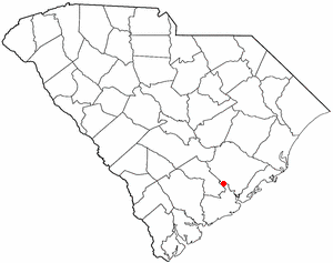
Dorchester County is a county located in the U.S. state of South Carolina. As of the 2020 census, the population was 161,540. Its county seat is St. George.

<span class="mw-page-title-main">Colleton County, South Carolina</span> County in South Carolina, United States

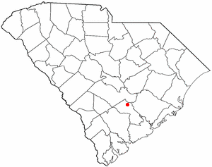
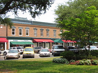
Colleton County is in the Lowcountry region of the U.S. state of South Carolina. As of the 2020 census, the population was 38,604. Its county seat is Walterboro. The county is named after Sir John Colleton, 1st Baronet, one of the eight Lords Proprietor of the Province of Carolina. After two previous incarnations, the current Colleton County was created in 1800.

<span class="mw-page-title-main">Berkeley County, South Carolina</span> County in South Carolina, United States

Berkeley County is a county in the U.S. state of South Carolina. As of the 2020 census, its population was 229,861. Its county seat is Moncks Corner, and the largest community is Goose Creek. After two previous incarnations of Berkeley County, the current county was created in 1882. Berkeley County is included in the Charleston-North Charleston, SC Metropolitan Statistical Area.

<span class="mw-page-title-main">Salley, South Carolina</span> Town in South Carolina, United States of America

Salley is a town in Aiken County, South Carolina, United States. The population was 398 at the 2010 census. It is part of the Augusta, Georgia metropolitan area. Salley is known for hosting the Chitlin Strut, a town-wide festival, every November.

<span class="mw-page-title-main">St. Stephen, South Carolina</span> Town in South Carolina, United States

St. Stephen is a town in Berkeley County, South Carolina, United States. The population was 1,697 at the 2010 census.

<span class="mw-page-title-main">St. Matthews, South Carolina</span> Town in South Carolina, United States

St. Matthews is a town in Calhoun County, South Carolina, United States. The population was 2,021 at the 2010 census, a decline from 2,107 in 2000. It is the county seat of Calhoun County.

<span class="mw-page-title-main">Lincolnville, South Carolina</span> Town in South Carolina, United States

Lincolnville is a town in Charleston County, South Carolina, United States. A very small portion of the town extends into Dorchester County. The population was 1,139 at the 2010 census, up from 904 in 2000.

<span class="mw-page-title-main">Great Falls, South Carolina</span> Town in South Carolina, United States

Great Falls is a town in Chester County, South Carolina, United States and is located fourteen miles southwest of Lancaster, South Carolina. The population was 1,951 at the 2020 census.

<span class="mw-page-title-main">Pageland, South Carolina</span> Town in South Carolina, United States

Pageland is a town in Chesterfield County, South Carolina, United States. It is the second largest town in Chesterfield County. The population was 2,760 at the 2010 census.

<span class="mw-page-title-main">Harleyville, South Carolina</span> Town in Dorchester County, South Carolina, United States

Harleyville is a town in Dorchester County, South Carolina, United States. The population was 677 at the 2010 census, up from 594 at the 2000 census. Harleyville is part of the Charleston-North Charleston-Summerville metropolitan area. As of 2018 the population is 696.

<span class="mw-page-title-main">Reevesville, South Carolina</span> Town in South Carolina, United States

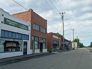
Reevesville is a town in Dorchester County, South Carolina, United States. The population was 196 at the 2010 census. As defined by the U.S. Office of Management and Budget, and used by the U.S. Census Bureau for statistical purposes only, Reevesville is included within the Charleston-North Charleston-Summerville metropolitan area.

<span class="mw-page-title-main">Ridgeville, South Carolina</span> Town in South Carolina, United States

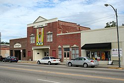
Ridgeville is a town in Dorchester County, South Carolina, United States. The population was 1,979 at the 2010 census, up from 1,690 at the 2000 census. Ridgeville is part of the Charleston-North Charleston-Summerville metropolitan area.

<span class="mw-page-title-main">Cope, South Carolina</span> Town in South Carolina, United States

Cope is a town in Orangeburg County, South Carolina, United States. The population was 65 at the 2020 census, a decline from 80 in 2010.

<span class="mw-page-title-main">Eutawville, South Carolina</span> Town in South Carolina, United States

Eutawville is a town in Orangeburg County, South Carolina, United States. Prior to 1910, Eutawville was located in the northwest portion of Saint James Goose Creek Township, Berkeley County. The population was 315 at the 2010 census.

<span class="mw-page-title-main">Holly Hill, South Carolina</span> Town in South Carolina, United States

Holly Hill is a town in Orangeburg County, South Carolina, United States. The population was 1,277 at the 2010 census. Prior to 1910 it was located in the northwest portion of Saint James Goose Creek Township.

<span class="mw-page-title-main">Santee, South Carolina</span> Town in South Carolina, United States

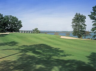
Santee is a town in Orangeburg County along the Santee River Valley in central South Carolina, United States. It has become a resort town of note located centrally north-south along the Atlantic Seaboard of South Carolina. The region has been rural, with a primarily agricultural economy typical of Orangeburg County, but is now known primarily for its several golf courses in proximity to Lake Marion, Santee State Park and other Lake Marion attractions. Interstate 95 connects its attractions easily with tourists traveling by automobile. I-95 crosses a narrow arm of the lake into the town lands, along a causeway. Lake Marion is a man-made hydroelectric reservoir, which at 110,000 acres is one of the fifty largest lakes in the country.

<span class="mw-page-title-main">Eastover, South Carolina</span> Town in South Carolina, United States

Eastover is a town in Richland County, South Carolina, United States. The population was 813 at the 2010 census, down from 830 in 2000. It is part of the Columbia, South Carolina, Metropolitan Statistical Area.

<span class="mw-page-title-main">Ladson, South Carolina</span> Census-designated place in South Carolina, United States

Ladson is a census-designated place (CDP) in Berkeley, Charleston and Dorchester counties in the U.S. state of South Carolina. The population was 13,790 at the 2010 census. It is named in honor of the Ladson family, one of the oldest planter and merchant families in the Charleston area; one of its members was lieutenant governor James Ladson.

<span class="mw-page-title-main">Summerville, South Carolina</span> Town in South Carolina, United States

Summerville is a town in the U.S. state of South Carolina situated mostly in Dorchester County, with small portions in Berkeley and Charleston counties. It is part of the Charleston-North Charleston-Summerville, SC Metropolitan Statistical Area. Summerville's population at the 2020 census was 50,915.

References

  1. "ArcGIS REST Services Directory". United States Census Bureau. Retrieved October 15, 2022.
  2. 1 2 "Census Population API". United States Census Bureau. Retrieved October 15, 2022.
  3. 1 2 "U.S. Census website". United States Census Bureau . Retrieved January 31, 2008.
  4. "US Board on Geographic Names". United States Geological Survey. October 25, 2007. Retrieved January 31, 2008.
  5. "Find a County". National Association of Counties. Retrieved June 7, 2011.
  6. "Town of St. George". Town of St. George. Retrieved November 1, 2023. The Town of St. George was incorporated by an act of the Legislature on January 28, 1875.
  7. Mauldin, G. E. (1928). "South Carolina Canal and Rail Road". The Railway and Locomotive Historical Society Bulletin (17): 70–80. ISSN   0033-8842.
  8. "National Register Information System". National Register of Historic Places . National Park Service. March 13, 2009.
  9. "Explore Census Data". data.census.gov. Retrieved December 15, 2021.
  10. "South Carolina libraries and archives". SCIWAY. Retrieved June 8, 2019.
  11. "About WGF". World Grits Festival. Retrieved April 9, 2022.
  12. "World Grits Festival happening this weekend in St. George". WCBD News 2. April 8, 2022. Retrieved April 9, 2022.