Pickens County, South Carolina

Last updated

Pickens County
PickensSCCourthouse.jpg
Pickens County Courthouse
Pickens County Seal.png
Pickens County Logo.png
Motto: 
"Adventure Starts Here"
Map of South Carolina highlighting Pickens County.svg
Location within the U.S. state of South Carolina
South Carolina in United States.svg
South Carolina's location within the U.S.
Coordinates: 34°53′N82°43′W / 34.89°N 82.72°W / 34.89; -82.72
CountryFlag of the United States.svg United States
StateFlag of South Carolina.svg  South Carolina
Founded1826
Named for Andrew Pickens
Seat Pickens
Largest community Easley
Area
  Total512.75 sq mi (1,328.0 km2)
  Land496.94 sq mi (1,287.1 km2)
  Water15.81 sq mi (40.9 km2)  3.67%
Population
 (2020)
  Total131,404
  Estimate 
(2023)
135,495
  Density264.43/sq mi (102.10/km2)
Time zone UTC−5 (Eastern)
  Summer (DST) UTC−4 (EDT)
Congressional district 3rd
Website www.co.pickens.sc.us

Pickens County is located in the northwest part of the U.S. state of South Carolina. As of the 2020 census, its population was 131,404. [1] Its county seat is Pickens. [2] The county was created in 1826. [3] It is part of the Greenville-Anderson-Greer, SC Metropolitan Statistical Area. [4]

Contents

History

Pickens County was part of Cherokee homeland territory until well after the American Revolution. The Cherokee had allied with the British, hoping to gain expulsion of European-American settlers from their lands. But they were defeated in local battles of the Revolution and forced to cede their lands under various treaties.

This former Cherokee territory was included in the new state's Ninety-Six Judicial District. In 1791 the state legislature established Washington District, a judicial area composed of present-day Greenville, Anderson, Pickens, and Oconee counties (the latter was not organized until 1868); at that time it also included Pendleton County.

Streets for the county seat and courthouse town of Pickensville (near present-day Easley) were laid off. New buildings perhaps included a large wooden hotel, which served as a stagecoach stop. In 1798 Washington District was divided into Greenville and Pendleton districts. The latter included what eventually became Anderson, Oconee, and Pickens counties. After a new courthouse was erected at Pendleton to accommodate the Court of General Sessions and Common Pleas, Pickensville began to decline.

In view of the growing population and poor transportation facilities in Pendleton District, the legislature divided it into counties in 1826. But a year later, it decided to establish judicial districts instead. The legislation went into effect in 1828. The lower part became Anderson and the upper Pickens, named in honor of Brigadier General Andrew Pickens of the American Revolution. His home, Hopewell, was on the southern border of the district. A courthouse was established on the west bank of the Keowee River, and a small town called Pickens Court House soon developed here. Since 1825, John C. Calhoun made his home in what became Pickens County, at Fort Hill, which became the basis around which Clemson University would later grow up.

By 1860 Pickens District had a population of more than 19,000 persons, of whom 22 percent were enslaved African Americans. The district was largely rural and agricultural, with cotton the most important commodity crop. Its small industry consisted mainly of sawmills, gristmills, and a few other shops producing goods for home consumption. The district's Protestant churches were numerous, but schools were few. The Blue Ridge Railroad reached the district in September 1860. There was little organized troop combat here during the Civil War, but the district was frequently plundered by marauders and deserters who swept down from the mountains.

Post-Civil War to present

After the war, the region was largely destitute. The South Carolina Constitutional Convention of 1868, meeting during the first year of Congressional Reconstruction, changed the name "district" to "county" throughout the state. The convention also organized Oconee County, from a portion of Pickens District that was west of the Keowee and Seneca rivers, plus a small area around the Fort Hill estate formerly belonging to statesman John C. Calhoun. In the 1960s, this small area around the Calhoun property was transferred to Pickens County.

A new courthouse for Pickens County was erected at its present location. Many of the residents of Old Pickens, on the Keowee River, moved to the newly created town, some relocating their dismantled homes. The loss of the Oconee area greatly reduced the population of Pickens County. It did not again reach 19,000 until 1900.

The county's growth was accelerated by the building of the Atlanta and Charlotte Air Line Railway (later called the Southern Railway) in the 1870s. The town of Easley, named for General W. K. Easley, was chartered in 1874. The towns of Liberty and Central sprang up along the railroad about the same time and were soon incorporated. Calhoun (now part of Clemson) was founded in the 1890s, to be followed in the early 1900s by Six Mile and Norris as incorporated areas.

A major factor in Pickens County's growth was the development of the regional textile industry, which had earlier been based in New England and New York. The county's first modern cotton mill, organized by D. K. Norris and others, was established at Cateechee in 1895. By 1900 the county boasted three cotton mills, two railroads, three banks, three roller mills, 37 sawmills, ten shingle mills, and four brickyards.

Yet until 1940, with a population of 37,000 (13.2 percent black), the county remained primarily rural and agricultural. Like many other Piedmont counties, Pickens had a one-crop economy. Its citizens were engaged mainly in growing cotton or manufacturing it into cloth. A notable change in the Pickens landscape was the coming of paved highways; one completed across the county, about 1930, ran from Greenville to Walhalla by way of Easley, Liberty, and Central. [5]

The most significant developments in the county's history have occurred since World War II. By 1972 there were 99 manufacturing plants in the county, employing almost 15,000 personnel and producing not only textiles but a wide variety of other products. The population today is estimated to be 93,894 residents. New residents continue to be attracted to Pickens County because of its climate, industrial opportunity, proximity to Greenville's labor market, and scenic beauty. [5]

Geography

Pickens County, South Carolina
Interactive map of Pickens County

According to the U.S. Census Bureau, the county has a total area of 512.75 square miles (1,328.0 km2), of which 496.94 square miles (1,287.1 km2) is land and 15.81 square miles (40.9 km2) (3.67%) is water. [6] The county also contains the highest natural point in South Carolina, Sassafras Mountain, with an elevation of 3,560 feet (1,090 m). [7] Table Rock State Park is in Pickens County.

Pickens County is in the Savannah River basin, the Saluda River basin, and the French Broad River basin.

State and local protected areas/sites

Major water bodies

Adjacent counties

Major highways

Major infrastructure

Demographics

Historical population
CensusPop.Note
1830 14,473
1840 14,356−0.8%
1850 16,90417.7%
1860 19,63916.2%
1870 10,269−47.7%
1880 14,38940.1%
1890 16,38913.9%
1900 19,37518.2%
1910 25,42231.2%
1920 28,32911.4%
1930 33,70919.0%
1940 37,11110.1%
1950 40,0587.9%
1960 46,03014.9%
1970 58,95628.1%
1980 79,29234.5%
1990 93,89418.4%
2000 110,75718.0%
2010 119,2247.6%
2020 131,40410.2%
2023 (est.)135,495 [1] 3.1%
U.S. Decennial Census [9]
1790–1960 [10] 1900–1990 [11]
1990–2000 [12] 2010 [13] 2020 [1]

2020 census

Pickens County racial composition [14]
RaceNum.Perc.
White (non-Hispanic)107,24781.62%
Black or African American (non-Hispanic)8,4216.41%
Native American 3040.23%
Asian 2,7232.07%
Pacific Islander 370.03%
Other/Mixed 6,1004.64%
Hispanic or Latino 6,5725.0%

As of the 2020 census, there were 131,404 people, 48,203 households, and 31,630 families residing in the county.

2010 census

At the 2010 census, there were 119,224 people, 45,228 households, and 29,540 families residing in the county. [15] [13] The population density was 240.2 inhabitants per square mile (92.7/km2). There were 51,244 housing units at an average density of 103.2 per square mile (39.8/km2). [16] The racial makeup of the county was 88.7% white, 6.6% black or African American, 1.6% Asian, 0.2% American Indian, 1.4% from other races, and 1.5% from two or more races. Those of Hispanic or Latino origin made up 3.1% of the population. [15] In terms of ancestry, [17]

Of the 45,228 households, 30.0% had children under the age of 18 living with them, 50.0% were married couples living together, 10.8% had a female householder with no husband present, 34.7% were non-families, and 25.2% of all households were made up of individuals. The average household size was 2.48 and the average family size was 2.95. The median age was 34.9 years. [15]

The median income for a household in the county was $41,898 and the median income for a family was $53,911. Males had a median income of $41,615 versus $31,464 for females. The per capita income for the county was $20,647. About 8.9% of families and 16.6% of the population were below the poverty line, including 18.3% of those under age 18 and 7.8% of those age 65 or over. [18]

2000 census

At the 2000 census, [19] there were 110,757 people, 41,306 households, and 28,459 families residing in the county. The population density was 223 people per square mile (86 people/km2). There were 46,000 housing units at an average density of 93 per square mile (36/km2). The racial makeup of the county was 90.27% White, 6.82% Black or African American, 0.16% Native American, 1.18% Asian, 0.01% Pacific Islander, 0.70% from other races, and 0.85% from two or more races. 1.70% of the population were Hispanic or Latino of any race. 27.9% were of American, 11.8% English, 11.6% Irish, 10.3% German and 5.0% Scotch-Irish ancestry according to Census 2000.

There were 41,306 households, out of which 31.20% had children under the age of 18 living with them, 55.60% were married couples living together, 9.40% had a female householder with no husband present, and 31.10% were non-families. 23.30% of all households were made up of individuals, and 8.20% had someone living alone who was 65 years of age or older. The average household size was 2.50 and the average family size was 2.95.

In the county, the population was spread out, with 22.30% under the age of 18, 17.50% from 18 to 24, 27.60% from 25 to 44, 21.20% from 45 to 64, and 11.40% who were 65 years of age or older. The median age was 33 years. For every 100 females, there were 99.60 males. For every 100 females age 18 and over, there were 98.20 males.

The median income for a household in the county was $36,214, and the median income for a family was $44,507. Males had a median income of $31,795 versus $22,600 for females. The per capita income for the county was $17,434. About 7.80% of families and 13.70% of the population were below the poverty line, including 12.20% of those under age 18 and 11.70% of those age 65 or over.

Law, government, and public safety

Police

The Pickens County Sheriff's Office is the largest law enforcement agency in the county, and provides its services to all unincorporated areas of the county, incorporated communities without a police department, and may assist a city or town police department upon request by the department. The sheriff's office consists of the command staff, administrative support division, uniform patrol division, detective division, and judicial services division. Within these divisions are the uniform patrol unit, the chaplain unit, special victims unit, sex offender unit, forensics unit, special operations unit, general investigations unit, animal enforcement unit, school resource officers unit, victim services unit, marine patrol unit, aviation unit, K-9 unit, professional standards unit, civil process unit, training unit, records unit, communications unit, detention unit, transport unit, court security unit, community action team, and special weapons and tactics team. The sheriff's office is headquartered at the Pickens County Law Enforcement Center in Pickens. The Pickens County Detention Center is a stand-alone facility located in Pickens that is also managed by the sheriff's office. The sheriff's office has a total of 199 full and part-time personnel. The current sheriff is Rick Clark.

The City of Easley Police Department is the second largest law enforcement agency in the county, and provides its services to persons living within the city limits of Easley. The department consists of an administration division, uniform patrol division, and detective division. There are 42 police officers and 3 civilians working for the department. The department is headquartered at the Easley Law Enforcement Center in downtown Easley. The current chief of police is Stan Whitten.

The City of Pickens Police Department provides its services to persons living within the city limits of Pickens. The department is headquartered at the Pickens Police Station next to the Pickens Fire Station. The current chief of police is Randall Beach.

The City of Clemson Police Department provides its services to persons living within the city limits of Clemson. The department is headquartered at the Clemson Law Enforcement Center. The current chief of police is Jimmy Dixon.

The City of Liberty Police Department provides its services to persons living within the city limits of Liberty. The department is headquartered at Liberty Town Hall in downtown Liberty. The current chief of police is Adam Gilstrap.

The Town of Central Police Department provides its services to persons living within the town limits of Central. The department consists of the chief of police, an investigative sergeant, training sergeant, five officers, and a victims advocate/administrative assistant. The department's headquarters are located in downtown Central.

The Clemson University Police Department provides its services to the Clemson University campus. The current police chief is Greg Mullen.

The South Carolina Highway Patrol provides its services on all roads, highways, and interstate highways in the county. There is one SCHP barracks in Pickens County, Post B, serving both Oconee and Pickens counties. Post B falls under SCHP Troop 3. (Oconee/Pickens/Anderson/Greenville/Spartanburg counties)

Fire safety

There is no countywide fire department, but several communities in the county do maintain their own fire departments.

  • Central Fire Department
  • Central Rural Fire Department
  • Clemson University Fire Department
  • Crosswell Fire Department
  • Dacusville Rural Fire Department
  • Easley Fire Department
  • Liberty Fire Department
  • Norris Fire Department
  • Pickens Fire Department
  • Six Mile Fire Department

Politics

Pickens County was one of the first areas of South Carolina to turn Republican. It has gone Republican all but twice since 1952, and at all times since 1980. Jimmy Carter's narrow loss in 1980 is the last time that a Democrat has won even 40 percent of the county's vote. Despite this, Democrats held most state and local offices well into the 1990s.

Since 2000, it has been the most Republican county in the state, with the GOP taking 70+ percent of the vote each time. In 2008, it was the only county in the state to give John McCain over 70% of the vote.

United States presidential election results for Pickens County, South Carolina [20] [21]
Year Republican Democratic Third party
No.%No.%No.%
2020 42,90774.56%13,64523.71%9941.73%
2016 36,23673.88%10,35421.11%2,4595.01%
2012 33,47473.49%11,15624.49%9192.02%
2008 32,55272.13%11,69125.91%8851.96%
2004 29,75973.46%10,28725.39%4641.15%
2000 24,68171.37%8,92725.81%9742.82%
1996 17,15161.47%8,36930.00%2,3808.53%
1992 17,00857.67%8,27528.06%4,21114.28%
1988 17,44873.63%6,10325.76%1450.61%
1984 15,15576.68%4,48122.67%1280.65%
1980 9,57553.42%7,78943.46%5593.12%
1976 8,02948.21%8,50551.07%1210.73%
1972 11,77682.37%2,25515.77%2651.85%
1968 6,87351.63%2,01615.14%4,42433.23%
1964 5,88262.63%3,50637.33%30.03%
1960 4,20162.26%2,54637.74%00.00%
1956 1,74740.84%1,84743.17%68415.99%
1952 3,09651.94%2,86548.06%00.00%
1948 1658.49%43522.38%1,34469.14%
1944 2118.55%1,66267.34%59524.11%
1940 763.46%2,12296.54%00.00%
1936 501.83%2,67898.17%00.00%
1932 572.08%2,68597.92%00.00%
1928 19214.75%1,11085.25%00.00%
1924 353.23%1,04496.49%30.28%
1920 636.19%95593.81%00.00%
1916 70.58%1,13995.08%524.34%
1912 151.77%81596.11%182.12%
1908 564.32%1,24195.68%00.00%
1904 60.65%91499.35%00.00%
1900 606.04%93393.96%00.00%
1896 17011.88%1,26188.12%00.00%
1892 12910.79%60350.42%46438.80%

Economy

In 2022, the GDP was $5 billion (about $37,089 per capita), [22] and the real GDP was $4.2 billion (about $30,795 per capita) in chained 2017 dollars. [23]

As of April 2024, some of the largest employers in the county include Aramark, the city of Clemson, Clemson University, Danfoss, Ingles, Lowe's, Merck & Co., Prisma Health, Publix, St. Jude Medical, and Walmart. [24]

Employment and Wage Statistics by Industry in Pickens County, South Carolina - Q3 2023 [24]
IndustryEmployment CountsEmployment Percentage (%)Average Annual Wage ($)
Accommodation and Food Services5,84815.219,292
Administrative and Support and Waste Management and Remediation Services9712.539,572
Agriculture, Forestry, Fishing and Hunting710.235,100
Arts, Entertainment, and Recreation1,1863.121,788
Construction1,3773.651,740
Educational Services8,19221.473,424
Finance and Insurance5751.567,340
Health Care and Social Assistance3,6799.656,056
Information1790.5124,228
Management of Companies and Enterprises530.181,484
Manufacturing5,18313.567,704
Other Services (except Public Administration)9162.436,452
Professional, Scientific, and Technical Services1,0252.775,764
Public Administration1,7714.644,772
Real Estate and Rental and Leasing3560.941,184
Retail Trade5,76915.032,136
Transportation and Warehousing3150.863,024
Utilities4011.084,656
Wholesale Trade4991.366,352
Total38,366100.0%50,879

Education

School districts

Pickens School District ranked the highest in the state with an "A−" transparency score from Sunshine Review. [25]

Schools

  • Ambler Elementary – Pickens
  • Central Elementary – Central
  • Chastain Road Elementary – Liberty
  • Clemson Elementary – Clemson
  • Crosswell Elementary – Easley
  • Dacusville Elementary – Dacusville
  • East End Elementary – Easley
  • Forest Acres Elementary – Easley
  • Hagood Elementary – Pickens
  • Liberty Elementary – Liberty
  • McKissick Elementary – Easley
  • Pickens Elementary – Pickens
  • Six Mile Elementary – Six Mile
  • West End Elementary – Easley
  • Dacusville Middle – Dacusville
  • Liberty Middle – Liberty
  • Pickens Middle – Pickens
  • R.C. Edwards Middle – Central
  • R.H. Gettys Middle – Easley
  • D.W. Daniel High – Central
  • Easley High School – Easley
  • Liberty High – Liberty
  • Pickens High School – Pickens

Colleges and universities

Public library

Pickens County is served by the Pickens County Library System, headquartered in Easley, with four branch libraries in the county.

Communities

Cities

Towns

Census-designated places

Unincorporated communities

Notable people

Shoeless Joe Jackson Shoeless Joe Jackson by Conlon, 1913.jpeg
Shoeless Joe Jackson

See also

Related Research Articles

<span class="mw-page-title-main">Spartanburg County, South Carolina</span> County in South Carolina, United States

Spartanburg County is a county located on the northwestern border of the U.S. state of South Carolina. As of the 2020 census, the population was 327,997, making it the fifth-most populous county in South Carolina. Its county seat is Spartanburg.

<span class="mw-page-title-main">Oconee County, South Carolina</span> County in South Carolina, United States

Oconee County is the westernmost county in the U.S. state of South Carolina. As of the 2020 census, the population was 78,607. Its county seat is Walhalla and its largest community is Seneca. Oconee County is included in the Seneca, SC Micropolitan Statistical Area, which is also included in the Greenville-Spartanburg-Anderson, SC Combined Statistical Area. South Carolina Highway 11, the Cherokee Foothills National Scenic Highway, begins in southern Oconee County at Interstate Highway 85 at the Georgia state line.

<span class="mw-page-title-main">Anderson County, South Carolina</span> County in South Carolina, United States

Anderson County is a county located in the U.S. state of South Carolina. As of the 2020 census, its population was 203,718. Its county seat is Anderson. Named for Revolutionary War leader Robert Anderson, the county is located in northwestern South Carolina, along the state line of Georgia. Anderson County is included in the Greenville-Anderson-Greer, SC Metropolitan Statistical Area. Anderson County contains 55,950-acre (22,640 ha) Lake Hartwell, a U.S. Army Corps of Engineers lake with nearly 1,000 miles (1,600 km) of shoreline for residential and recreational use. The area is a growing industrial, commercial and tourist center. It is the home of Anderson University, a private, selective comprehensive university of approximately 4,000 undergraduate and graduate students.

<span class="mw-page-title-main">Anderson, South Carolina</span> City in South Carolina, United States

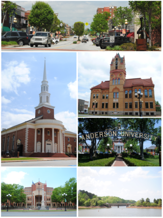
Anderson is a city in and the county seat of Anderson County, South Carolina, United States. The population was 28,106 at the 2020 census, making it the 16th-most populous city in South Carolina. It is one of the principal cities in the Greenville-Anderson-Greer, SC Metropolitan Statistical Area, which had an estimated population of 975,480 in 2023. It is included in the larger Greenville-Spartanburg-Anderson, SC Combined Statistical Area, which had an estimated population of 1,590,636 in 2023. It is just off Interstate 85 and is 120 miles (190 km) from Atlanta and 140 miles (230 km) from Charlotte. Anderson is the smallest of the three primary cities that make up the Upstate region, and is nicknamed the "Electric City" and the "Friendliest City in South Carolina".

<span class="mw-page-title-main">Pendleton, South Carolina</span> Town in South Carolina, United States

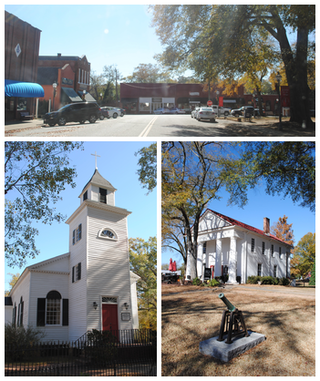
Pendleton is a town in Anderson County, South Carolina, United States. The population was 3,489 at the 2020 census. It is a sister city of Stornoway in the Outer Hebrides of Scotland.

<span class="mw-page-title-main">Williamston, South Carolina</span> Town in South Carolina, United States

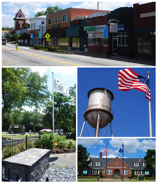
Williamston is a town in Anderson County, South Carolina. The population was 4,043 at the 2020 census.

Five Forks is a census-designated place (CDP) in Greenville County, South Carolina, United States. The population was 17,737 at the 2020 census, up from 14,140 in 2010, and 8,064 in 2000. It is a growing, affluent suburb of Greenville and is part of the Greenville–Mauldin–Easley Metropolitan Statistical Area.

Parker is a census-designated place (CDP) in Greenville County, South Carolina, United States. The population was 11,431 at the 2010 census, up from 10,760 in 2000. It is part of the Greenville–Mauldin–Easley Metropolitan Statistical Area.

<span class="mw-page-title-main">Salem, South Carolina</span> Town in South Carolina, United States

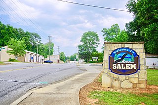
Salem is a U.S. town in Oconee County, South Carolina. The population was 135 at the 2010 United States Census.

<span class="mw-page-title-main">Seneca, South Carolina</span> City in Oconee County, South Carolina

Seneca is a city in Oconee County, South Carolina, United States. The population was 8,102 at the 2010 census. It is the principal city of the Seneca Micropolitan Statistical Area, an (MSA) that includes all of Oconee County, and that is included within the greater Greenville-Spartanburg-Anderson, South Carolina Combined Statistical Area. Seneca was named for the nearby Cherokee town of Isunigu, which English colonists knew as "Seneca Town".

<span class="mw-page-title-main">Walhalla, South Carolina</span> City in South Carolina, United States

Walhalla is a city in the foothills of the Blue Ridge Mountains in Oconee County, South Carolina. Designated in 1868 as the county seat, it lies within the area of the Blue Ridge Escarpment, an area of transition between mountains and piedmont, and contains numerous waterfalls. It is located 16 miles (26 km) from Clemson University in Clemson, South Carolina.

<span class="mw-page-title-main">Central, South Carolina</span> Town in South Carolina, United States

Central is a town in Pickens County, South Carolina, United States. As of the 2010 census, the population was 5,159, roughly 3,000 of whom were considered permanent residents. Contrary to its name, it is not near South Carolina's center. It received its name from being halfway or the central point between Atlanta and Charlotte along the former Atlanta and Richmond Air-Line Railway line. Southern Wesleyan University's main campus is east of downtown Central.

<span class="mw-page-title-main">Easley, South Carolina</span> City in South Carolina, United States

Easley is a city in Pickens County in the U.S. state of South Carolina. Most of the city lies in Pickens County, with a small portion of the city in Anderson County.

<span class="mw-page-title-main">Liberty, South Carolina</span> City in South Carolina, United States

Liberty is a city in Pickens County, South Carolina, United States. It is part of the Greenville–Mauldin–Easley Metropolitan Statistical Area. The city was chartered on March 2, 1876.

<span class="mw-page-title-main">Pickens, South Carolina</span> City in South Carolina, United States

Pickens, formerly called Pickens Courthouse, is a city in and the county seat of Pickens County, South Carolina, United States. The population was 3,126 at the 2010 census. Pickens changed its classification from a town to a city in 1998, but it was not reported to the Census Bureau until 2001. It was named after Andrew Pickens (1739–1817), an American revolutionary soldier and US Congressman for South Carolina.

<span class="mw-page-title-main">Clemson, South Carolina</span> City in South Carolina, United States

Clemson is a city in Pickens and Anderson counties in the U.S. state of South Carolina. Clemson is home to Clemson University; in 2015, the Princeton Review cited the town of Clemson as ranking #1 in the United States for "town-and-gown" relations with its resident university. The population of the city was 17,681 at the 2020 census.

<span class="mw-page-title-main">U.S. Route 123</span> Highway in the United States

U.S. Route 123 is a spur of US 23 in the U.S. states of Georgia and South Carolina. The U.S. Highway runs 75.12 miles (120.89 km) from US 23, US 441, SR 15 and SR 365 near Clarkesville, Georgia, north and east to Interstate 385 Business in Greenville, South Carolina. US 123 parallels I-85 to the north as it connects the Northeast Georgia cities of Clarkesville and Toccoa with the western Upstate South Carolina communities of Westminster, Seneca, Clemson, Easley, and Greenville.

<span class="mw-page-title-main">Lake Keowee</span> Man-made lake in South Carolina, United States

Lake Keowee is a man-made reservoir in the United States in the state of South Carolina. It was developed to serve the needs of power utility Duke Energy and public recreational purposes. It is approximately 26 miles (42 km) long, 3 miles (4.8 km) wide, with an average depth of 54 feet (16 m), and a shoreline measured at 300 miles (480 km) in total, and is approximately 800 feet (240 m) above sea level.

<span class="mw-page-title-main">Old Stone Church and Cemetery</span> Historic site in South Carolina, United States

Old Stone Church is a church building built in 1802. When it was constructed, it was in the Pendleton District, South Carolina. When Pendleton District was divided in 1826, the church was in Pickens District. When Pickens District was split in 1868, it was in Oconee County, South Carolina. In 1968, this section of Oconee County was annexed back to Pickens County. The church is about midway between the centers of Pendleton and Clemson. It is now in the city limits of Clemson.

Keowee Key is a lakeside community and census-designated place (CDP) in Oconee County, South Carolina, United States. It is considered part of the Salem community. It was first listed as a CDP prior to the 2020 census with a population of 2,716.

References

  1. 1 2 3 "QuickFacts: Pickens County, South Carolina". United States Census Bureau. Retrieved March 22, 2024.
  2. "Find a County". National Association of Counties. Retrieved June 7, 2011.
  3. "South Carolina: Individual County Chronologies". South Carolina Atlas of Historical County Boundaries. The Newberry Library. 2009. Archived from the original on January 3, 2017. Retrieved March 21, 2015.
  4. "OMB Bulletin No. 23-01: Revised Delineations of Metropolitan Statistical Areas, Micropolitan Statistical Areas, and Combined Statistical Areas, and Guidance on Uses of the Delineations of These Areas" (PDF). United States Office of Management and Budget . July 21, 2023. Retrieved August 10, 2023.
  5. 1 2 "History". Co.pickens.sc.us. Retrieved January 2, 2018.
  6. "2020 County Gazetteer Files – South Carolina". United States Census Bureau. August 23, 2022. Retrieved September 10, 2023.
  7. "Sassafras Mountain : Climbing, Hiking & Mountaineering : SummitPost". Summitpost.org. Retrieved January 2, 2018.
  8. 1 2 3 4 5 6 7 8 "SCDNR Public Lands". www2.dnr.sc.gov. Retrieved April 1, 2023.
  9. "U.S. Decennial Census". United States Census Bureau. Retrieved March 18, 2015.
  10. "Historical Census Browser". University of Virginia Library. Retrieved March 18, 2015.
  11. Forstall, Richard L., ed. (March 27, 1995). "Population of Counties by Decennial Census: 1900 to 1990". United States Census Bureau. Retrieved March 18, 2015.
  12. "Census 2000 PHC-T-4. Ranking Tables for Counties: 1990 and 2000" (PDF). United States Census Bureau. April 2, 2001. Archived (PDF) from the original on October 9, 2022. Retrieved March 18, 2015.
  13. 1 2 "State & County QuickFacts". United States Census Bureau. Archived from the original on June 6, 2011. Retrieved November 25, 2013.
  14. "Explore Census Data". data.census.gov. Retrieved December 14, 2021.
  15. 1 2 3 "DP-1 Profile of General Population and Housing Characteristics: 2010 Demographic Profile Data". United States Census Bureau. Archived from the original on February 13, 2020. Retrieved March 11, 2016.
  16. "Population, Housing Units, Area, and Density: 2010 - County". United States Census Bureau. Archived from the original on February 13, 2020. Retrieved March 11, 2016.
  17. "DP02 SELECTED SOCIAL CHARACTERISTICS IN THE UNITED STATES – 2006-2010 American Community Survey 5-Year Estimates". United States Census Bureau. Archived from the original on February 13, 2020. Retrieved March 11, 2016.
  18. "DP03 SELECTED ECONOMIC CHARACTERISTICS – 2006-2010 American Community Survey 5-Year Estimates". United States Census Bureau. Archived from the original on February 13, 2020. Retrieved March 11, 2016.
  19. "U.S. Census website". United States Census Bureau . Retrieved May 14, 2011.
  20. Leip, David. "Dave Leip's Atlas of U.S. Presidential Elections". Uselectionatlas.org. Retrieved January 2, 2018.
  21. "Géographie électorale". geoelections.free.fr. Archived from the original on November 18, 2005. Retrieved January 13, 2021.
  22. U.S. Bureau of Economic Analysis (January 1, 2001). "Gross Domestic Product: All Industries in Pickens County, SC". FRED, Federal Reserve Bank of St. Louis. Retrieved May 4, 2024.
  23. U.S. Bureau of Economic Analysis (January 1, 2001). "Real Gross Domestic Product: All Industries in Pickens County, SC". FRED, Federal Reserve Bank of St. Louis. Retrieved May 4, 2024.
  24. 1 2 "Pickens County" (PDF). Community Profiles (04000077). Columbia, SC: S.C. Department of Employment & Workforce - Business Intelligence Department. April 19, 2024.
  25. "Independent Mail, Pickens School District ranked highest in transparency, June 23, 2010". Independentmail.com. Archived from the original on June 29, 2011. Retrieved January 2, 2018.