Six Mile, South Carolina

Last updated

Six Mile, South Carolina
SixMileSCMon.png
Top, left to right: Six Mile Town Hall, Liberty Highway, Six Mile Baptist Church, view of nearby mountain from Main Street
SCMap-doton-SixMile.PNG
Location of Six Mile, South Carolina
Coordinates: 34°48′7″N82°49′4″W / 34.80194°N 82.81778°W / 34.80194; -82.81778
Country United States
State South Carolina
County Pickens
Area
[1]
  Total2.05 sq mi (5.31 km2)
  Land2.04 sq mi (5.28 km2)
  Water0.01 sq mi (0.03 km2)
Elevation
1,024 ft (312 m)
Population
 (2020) [2]
  Total759
  Density372.42/sq mi (143.81/km2)
Time zone UTC−5 (Eastern (EST))
  Summer (DST) UTC−4 (EDT)
ZIP Code
29682
Area code 864
FIPS code 45-66760 [3]
GNIS feature ID1226654 [4]
Website www.sixmilesc.org

Six Mile is a town in Pickens County, South Carolina, United States. The 2010 census showed a population of 675, representing a 21% increase since 2000. The 2020 census showed a population of 678 representing a 0.30% increase since 2010. The average household income in Six Mile is $82,828 with a poverty rate at 6.54%. The median rental costs in recent years is $618 per month, and the median house value is $258,700

Contents

Six Mile was named "Six Mile" because it was located six miles from Fort Prince George. Many other landmarks in this area were named by their distance from Fort Prince George such as 12 Mile River, 18 Mile Creek, and Ninety Six. [5]

Geography

Six Mile is located at 34°48′7″N82°49′4″W / 34.80194°N 82.81778°W / 34.80194; -82.81778 (34.801983, −82.817857). [6]

According to the United States Census Bureau, the town has a total area of 1.8 square miles (4.7 km2), of which 1.8 square miles (4.7 km2) is land and 0.55% is water.

Climate

The climate is mild and temperate with rainfall evenly distributed throughout the year. Winters are moderate with an average monthly temperature of 43. Snowfall occurs each winter, but significant amounts come only once every two or three years. Spring is a period of transition with March the month for heavy rains. As the showers decrease, a secondary dry period occurs late in April and early May. Steady rains typical of winter are likely in early spring. The average date of the last spring freeze falls around the end of March, which gives the area a growing season of approximately 180–200 days. Summers are warm and long with the average temperatures hovering around 79. Temperatures reach 90 on an average of 48 days a year. Six Mile's warm and pleasant autumn is the driest season of the year with the first frost usually occurring the first week of November.

Demographics

Historical population
CensusPop.Note
1920 134
1930 15011.9%
1940 1521.3%
1950 1573.3%
1960 21838.9%
1970 36165.6%
1980 47030.2%
1990 56219.6%
2000 553−1.6%
2010 67522.1%
2020 75912.4%
U.S. Decennial Census [7] [2]

The 2010 census showed a population of 675; this is a 21% growth increase since the 2000 census.

There were 200 households, out of which 37.5% had children under the age of 18 living with them, 67.0% were married couples living together, 7.0% had a female householder with no husband present, and 23.0% were non-families. Of all households, 20.0% were made up of individuals, and 8.0% had someone living alone who was 65 years of age or older. The average household size was 2.60 and the average family size was 3.02.

In the town, the population was spread out, with 24.1% under the age of 18, 8.1% from 18 to 24, 26.9% from 25 to 44, 25.5% from 45 to 64, and 15.4% who were 65 years of age or older. The median age was 40 years. For every 100 females, there were 96.8 males. For every 100 females age 18 and over, there were 97.2 males.

The median income for a household in the town in 2012 was $53,143, and the median income for a family was $57,667. Males had a median income of $42,792 versus $27,000 for females. The per capita income for the town was $25,260. About 3.5% of families and 4.5% of the population were below the poverty line, including 12.3% of those under age 18 and none of those age 65 or over.

Related Research Articles

<span class="mw-page-title-main">Mosses, Alabama</span> Town in Alabama, United States

Mosses is a town in Lowndes County, Alabama, United States. At the 2010 census the population was 1,029, down from 1,101 in 2000. It is part of the Montgomery Metropolitan Statistical Area. It incorporated in 1979.

<span class="mw-page-title-main">Shongopovi, Arizona</span> CDP in Navajo County, Arizona

Shongopovi is a census-designated place (CDP) in Navajo County, Arizona, United States. It is located on the Second Mesa, within the Hopi Reservation.

<span class="mw-page-title-main">Lake City, Arkansas</span> City in Arkansas, United States

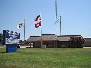
Lake City is a city in Craighead County, Arkansas, United States, along the St. Francis River. Lake City is one of two county seats in Craighead County. The population was 2,326 as of the 2020 census. It is included in the Jonesboro, Arkansas Metropolitan Statistical Area.

<span class="mw-page-title-main">Lewisville, Arkansas</span> City in Arkansas, United States

Lewisville is a city in Lafayette County, Arkansas, United States. The population was 1,280 at the 2010 census. It is the county seat of Lafayette County.

<span class="mw-page-title-main">Redington Shores, Florida</span> Town in the state of Florida, United States

Redington Shores is a town in Pinellas County, Florida, United States. The county is part of the Tampa–St. Petersburg–Clearwater Metropolitan Statistical Area, more commonly known as the Tampa Bay Area. The population was 2,176 at the 2020 census.

<span class="mw-page-title-main">Notus, Idaho</span> City in Idaho, United States

Notus is a small rural city in Canyon County, Idaho. The population was 531 at the time of the 2010 census and is the smallest town out of the eight in Canyon County. It is part of the Boise metropolitan area.

Jonesboro is a town in Washington County, Maine, United States. The town was named for John Coffin Jones, a landholder. The population was 587 at the 2020 census.

Salem Township is a civil township of Allegan County in the U.S. state of Michigan. The population was 5,156 at the 2020 census, up from 3,486 at the 2000 census.

<span class="mw-page-title-main">Antwerp, Ohio</span> Village in Ohio, United States

Antwerp is a village in Paulding County, Ohio, United States, along the Maumee River. The population was 1,676 at the 2020 census.

<span class="mw-page-title-main">Branchville, South Carolina</span> Town in South Carolina, United States

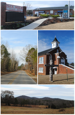
Branchville is a town in Orangeburg County, South Carolina, United States. The population was 1,024 at the 2010 census.

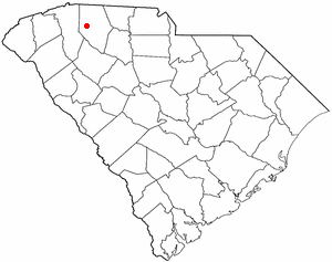
Norris is a town in Pickens County, South Carolina, United States. The population was 813 at the 2010 census. It is part of the Greenville–Mauldin–Easley Metropolitan Statistical Area.

<span class="mw-page-title-main">Campobello, South Carolina</span> Town in South Carolina, United States

Campobello is a town in Spartanburg County, South Carolina, United States, along the South Pacolet River. The population was 502 at the 2010 census.

<span class="mw-page-title-main">Wellford, South Carolina</span> City in South Carolina, United States

Wellford is a city in Spartanburg County, South Carolina, United States. The population was 3,293 at the 2020 census, up from 2,378 in 2010.

<span class="mw-page-title-main">Yznaga, Texas</span> Census-designated place in Texas, United States

Yznaga is a census-designated place (CDP) in Cameron County, Texas, United States. The population was 91 at the 2010 census. It is part of the Brownsville–Harlingen Metropolitan Statistical Area.

<span class="mw-page-title-main">Kanarraville, Utah</span> Town in Utah, United States

Kanarraville is a town in Iron County, Utah, United States. The population was 355 at the 2010 census.

<span class="mw-page-title-main">Eatonville, Washington</span> Town in Washington, United States

Eatonville is a town in Pierce County, Washington, United States. It is 32 mi (51 km) south of Tacoma. The population was 2,845 at the 2020 census. The town motto is "Better Together".

<span class="mw-page-title-main">Hamlin, West Virginia</span> Town in West Virginia, United States

Hamlin is a town in and the county seat of Lincoln County, West Virginia, United States, along the Mud River. The population was recorded as 1,040 at the 2020 census. It is part of the Huntington–Ashland metropolitan area.

<span class="mw-page-title-main">Henderson, West Virginia</span> Unincorporated Town in West Virginia, United States

Henderson is an unincorporated community and former town in Mason County, West Virginia, United States, at the confluence of the Ohio and Kanawha Rivers. The population was 231 at the 2020 census. It is part of the Point Pleasant, WV–OH Micropolitan Statistical Area. The town was incorporated in 1893 and named for Samuel Bruce Henderson, who owned the townsite at the time. The town was unincorporated following a public hearing on August 11, 2022.

<span class="mw-page-title-main">Stratford, Wisconsin</span> Village in Wisconsin, United States

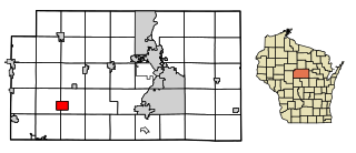
Stratford is a village in Marathon County, Wisconsin, United States. It is part of the Wausau, Wisconsin Metropolitan Statistical Area. The population was 1,578 at the 2010 census.

<span class="mw-page-title-main">Silerton, Tennessee</span> Town in Tennessee, United States

Silerton is a town in Hardeman and Chester counties in the western part of Tennessee. The population was 111 at the 2010 census.

References

  1. "ArcGIS REST Services Directory". United States Census Bureau. Retrieved October 15, 2022.
  2. 1 2 "Census Population API". United States Census Bureau. Retrieved October 15, 2022.
  3. "U.S. Census website". United States Census Bureau . Retrieved January 31, 2008.
  4. "US Board on Geographic Names". United States Geological Survey. October 25, 2007. Retrieved January 31, 2008.
  5. "History & Climate". The Town of Six Mile. Retrieved December 8, 2012.
  6. "US Gazetteer files: 2010, 2000, and 1990". United States Census Bureau. February 12, 2011. Retrieved April 23, 2011.
  7. "Census of Population and Housing". Census.gov. Retrieved June 4, 2015.