
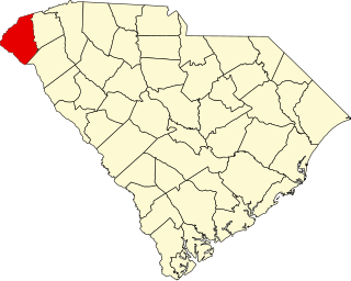
Oconee County is the westernmost county in the U.S. state of South Carolina. As of the 2020 census, the population was 78,607. Its county seat is Walhalla and its largest city is Seneca. Oconee County is included in the Seneca, SC Micropolitan Statistical Area, which is also included in the Greenville-Spartanburg-Anderson, SC Combined Statistical Area. South Carolina Highway 11, the Cherokee Foothills National Scenic Highway, begins in southern Oconee County at Interstate Highway 85 at the Georgia state line.

Seneca is a city in Oconee County, South Carolina, United States. The population was 8,102 at the 2010 census. It is the principal city of the Seneca Micropolitan Statistical Area, an (MSA) that includes all of Oconee County, and that is included within the greater Greenville-Spartanburg-Anderson, South Carolina Combined Statistical Area. Seneca was named for the nearby Cherokee town of Isunigu, which English colonists knew as "Seneca Town".

This is a list of the properties and historic districts in each of the 46 counties of South Carolina that are designated National Register of Historic Places.
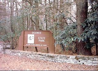
Oconee State Park is a state park located in the Blue Ridge Mountain region of South Carolina. This 1165-acre (472 ha) park has several recreational opportunities to choose from. They include cabins, camping, fishing and boating in the two small lakes located on the park grounds, hiking on eight nature/hiking trails, and several picnic and meeting facilities.

Stumphouse Mountain Tunnel in Oconee County, South Carolina is an incomplete railroad tunnel for the Blue Ridge Railroad of South Carolina in Sumter National Forest. The tunnel, along with nearby Issaqueena Falls, are now a Walhalla city park.

Oconee Station was established in 1792 as a blockhouse on the South Carolina frontier. Troops were removed in 1799. The site also encompasses the Williams Richards House, which was built in the early 19th century as a residence and trading post. The site is listed on the National Register of Historic Places in 1971 as Oconee Station and Richards House.

Old Stone Church is a church building built in 1802. When it was constructed, it was in the Pendleton District, South Carolina. When Pendleton District was divided in 1826, the church was in Pickens District. When Pickens District was split in 1868, it was in Oconee County, South Carolina. In 1968, this section of Oconee County was annexed back to Pickens County. The church is about midway between the centers of Pendleton and Clemson. It is now in the city limits of Clemson.
WSNW is a radio station broadcasting an adult contemporary and soft rock music format. Licensed to Seneca, South Carolina, United States, the station is currently owned by Toccoa Foundation, Inc. WSNW will have to move its city of license to Walhalla because WGOG will be moving its city of license to Powdersville, and the FCC is requiring that a radio station continue to be licensed to Walhalla. WSNW will be increasing its power to 5,000 watts during the day so that the station can still use the existing tower on Radio Station Road. WSNW can remain at its Ram Cat Alley studios because the studios must be within 25 miles of the city of license. Programming will also remain the same.

The Walhalla Graded School, built in 1901, is an historic building located at 101 E. North Broad Street in Walhalla, South Carolina. It was designed by noted Columbia architect William Augustus Edwards of the firm of Edwards and Walter and built by Grandy & Jordan of Greenville.
Seneca Historic District may refer to:
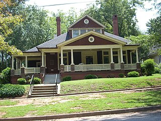
Seneca Historic District is a historic district in Seneca, South Carolina, United States, that is listed on the National Register of Historic Places.
This is a list of the National Register of Historic Places listings in Oconee County, South Carolina.

The McPhail Angus Farm is a farm at 320 Coyote Trail near Seneca, South Carolina in Oconee County. It is also known as the Tokena Angus Farm. It was named to the National Register of Historic Places as a historic district on November 7, 2007. It was named because of its significance to the transition from a nineteenth-century cotton farm to a twentieth-century, Upstate, cattle farm.

The Oconee County Cage is a former jail on wheels that is located at Browns Square Drive outside of the Oconee Heritage Center in Walhalla, South Carolina, USA in Oconee County. At the time of its listing, it was located on Church Street at the Oconee County Law Enforcement Center. It was named to the National Register of Historic Places on November 14, 1982 along with the Oconee County Jail. At the time of its listing, the cage was considered the most intact cage in South Carolina. Oconee County has preserved the cage as a reminder of the former harsh conditions faced by convicts in the early twentieth century.

The Long Creek Academy is a former Christian school that is located at the intersection of Academy Road and South Carolina S-37-339 near U.S. Route 76 near Long Creek, South Carolina in Oconee County. It was named to the National Register of Historic Places on November 20, 1987. It is currently used by a whitewater rafting company.

Old Pickens Presbyterian Church is a historic church in Seneca, South Carolina.

Retreat Rosenwald School, also known as the Retreat Colored School, is a historic Rosenwald School located at Westminster, Oconee County, South Carolina.
Russell House was a historic inn located near Mountain Rest, Oconee County, South Carolina. It was built about 1867, and considerably expanded around 1890, and served as an inn for travelers between Walhalla and the mountain resort area. The Russell House, two storage buildings, and a privy were destroyed by fire in 1988. Located on the property are the contributing ruins of a log barn, a spring house, outhouse, garage, corn crib, and potato cellar.

The historic Cherokee settlements were Cherokee settlements established in Southeastern North America up to the removals of the early 19th century. Several settlements had existed prior to and were initially contacted by explorers and colonists of the colonial powers as they made inroads into frontier areas. Others were established later.

The Faith Cabin Library at Seneca Junior College is a Faith Cabin Library built to serve the African American community in Seneca, South Carolina. It was built on the campus of the Seneca Junior College. The log cabin library building was named to the National Register of Historic Places on November 14, 2012.


