West Union, South Carolina

Last updated

West Union, South Carolina
West-Union-entrance-sc.jpg
Entrance along Main Street
Oconee County South Carolina incorporated and unincorporated areas West Union highlighted.svg
Location in Oconee County and the state of South Carolina.
Coordinates: 34°45′29″N83°2′30″W / 34.75806°N 83.04167°W / 34.75806; -83.04167
Country United States
State South Carolina
County Oconee
Area
[1]
  Total0.79 sq mi (2.06 km2)
  Land0.79 sq mi (2.05 km2)
  Water0.00 sq mi (0.00 km2)
Elevation
[2]
991 ft (302 m)
Population
 (2020) [3]
  Total374
  Density471.63/sq mi (182.17/km2)
Time zone UTC-5 (Eastern (EST))
  Summer (DST) UTC-4 (EDT)
ZIP code
29696
Area code 864
FIPS code 45-76435 [4]
GNIS feature ID1231908 [2]
Website townofwestunion.com

West Union is a town in Oconee County, South Carolina, United States. Although its name suggests that it is near Union, they are approximately four counties apart. The population was 291 at the 2010 census.

Contents

Geography

West Union is located at 34°45′29″N83°2′30″W / 34.75806°N 83.04167°W / 34.75806; -83.04167 (34.758141, -83.041740). [5] The town is located along South Carolina Highway 11, mostly northeast of the highway's intersection with South Carolina Highway 28. The larger city of Walhalla borders the town to the west, and Lake Keowee lies just a few miles to the east.

According to the United States Census Bureau, the town has a total area of 0.8 square mile (2.0 km2), all land.

Demographics

Historical population
CensusPop.Note
1880 192
1890 23522.4%
1900 28923.0%
1910 32813.5%
1920 306−6.7%
1930 3091.0%
1940 44945.3%
1950 429−4.5%
1960 4433.3%
1970 388−12.4%
1980 300−22.7%
1990 260−13.3%
2000 29714.2%
2010 291−2.0%
2020 37428.5%
U.S. Decennial Census [6] [3]

As of the census [4] of 2000, there were 297 people, 134 households, and 79 families residing in the town. The population density was 386.2 inhabitants per square mile (149.1/km2). There were 145 housing units at an average density of 188.6 per square mile (72.8/km2). The racial makeup of the town was 87.54% White, 0.67% African American, 3.03% Native American, 7.74% from other races, and 1.01% from two or more races. Hispanic or Latino of any race were 15.82% of the population.

There were 134 households, out of which 21.6% had children under the age of 18 living with them, 49.3% were married couples living together, 6.7% had a female householder with no husband present, and 41.0% were non-families. 38.1% of all households were made up of individuals, and 15.7% had someone living alone who was 65 years of age or older. The average household size was 2.22 and the average family size was 2.95.

In the town, the population was spread out, with 19.5% under the age of 18, 12.8% from 18 to 24, 20.9% from 25 to 44, 30.3% from 45 to 64, and 16.5% who were 65 years of age or older. The median age was 44 years. For every 100 females, there were 104.8 males. For every 100 females age 18 and over, there were 106.0 males.

The median income for a household in the town was $24,250, and the median income for a family was $35,000. Males had a median income of $25,625 versus $21,875 for females. The per capita income for the town was $13,753. About 18.9% of families and 27.1% of the population were below the poverty line, including 43.1% of those under the age of eighteen and 2.9% of those 65 or over.

Related Research Articles

<span class="mw-page-title-main">Union County, Georgia</span> County in Georgia, United States

Union County is a county located in the north central portion of the U.S. state of Georgia. As of the 2020 census, the population was 24,632. The county seat is Blairsville.

<span class="mw-page-title-main">Rural Hall, North Carolina</span> Town in North Carolina, United States

Rural Hall is a town in Forsyth County, North Carolina, United States. It is a part of the Piedmont Triad. The population was 3,360 at the 2020 census. The town has one public park: Covington Memorial Park.

<span class="mw-page-title-main">East Flat Rock, North Carolina</span> Census-designated place in North Carolina, United States

East Flat Rock is an unincorporated area and census-designated place (CDP) in Henderson County, North Carolina, United States. The population was 4,995 at the 2010 census, up from 4,151 at the 2000 census. It is part of the Asheville Metropolitan Statistical Area.

<span class="mw-page-title-main">Leroy Township, Bradford County, Pennsylvania</span> Township in Pennsylvania, United States

LeRoy Township is a township in Bradford County, Pennsylvania, United States. It is part of Northeastern Pennsylvania. The population was 718 at the 2010 census.

<span class="mw-page-title-main">Cooper Township, Clearfield County, Pennsylvania</span> Township in Pennsylvania, United States

Cooper Township is a township in Clearfield County, Pennsylvania, United States. The population was 2,593 at the 2020 census.

<span class="mw-page-title-main">Springfield Township, York County, Pennsylvania</span> Township in Pennsylvania, United States

Springfield Township is a township in York County, Pennsylvania, United States. The population was 6,023 at the 2020 census.

<span class="mw-page-title-main">Calhoun Falls, South Carolina</span> Town in South Carolina, United States

Calhoun Falls is a town in Abbeville County, South Carolina, United States. The population was 1,724 at the 2020 census, down from 2,004 at the 2010 census.

<span class="mw-page-title-main">Snelling, South Carolina</span> Town in South Carolina, United States

Snelling is a town in Barnwell County, South Carolina, United States. The population was 274 at the 2010 census.

<span class="mw-page-title-main">Richburg, South Carolina</span> Town in South Carolina, United States

Richburg is a town in Chester County, South Carolina, United States. The population was 275 at the 2010 census, down from 332 at the 2000 census.

<span class="mw-page-title-main">Chesterfield, South Carolina</span> Town in South Carolina, United States

Chesterfield is a town in Chesterfield County, South Carolina, United States. The population was 1,472 at the 2010 census. It is the county seat of Chesterfield County. At the time of the 2010 census, Chesterfield was the least populous of all of South Carolina's county seats.

<span class="mw-page-title-main">Mount Croghan, South Carolina</span> Town in South Carolina, United States

Mount Croghan is a town in Chesterfield County, South Carolina, United States. The population was 195 at the 2010 census, up from 155 in 2000. It houses a Flea market

<span class="mw-page-title-main">Ridgeway, South Carolina</span> Town in South Carolina, United States

Ridgeway is a town in Fairfield County, South Carolina, United States. The population was 319 at the 2010 census. It is part of the Columbia, SC Metropolitan Statistical Area.

Duncan is a census-designated place (CDP) in Greenville County, South Carolina, United States. The population was 3,671 at the 2010 census, down from 4,158 in 2000. It is part of the Greenville–Mauldin–Easley Metropolitan Statistical Area.

Parker is a census-designated place (CDP) in Greenville County, South Carolina, United States. The population was 11,431 at the 2010 census, up from 10,760 in 2000. It is part of the Greenville–Mauldin–Easley Metropolitan Statistical Area.

Varnville is a town in Hampton County, South Carolina, United States. The population was 2,162 as of the 2010 census. Varnville forms a twin town with Hampton, the county seat; the two towns often share civic and cultural events.

<span class="mw-page-title-main">Peak, South Carolina</span> Town in South Carolina, United States

Peak is a town in Newberry County, South Carolina, United States. The population was 64 at the 2010 census.

<span class="mw-page-title-main">Silverstreet, South Carolina</span> Town in South Carolina, United States

Silverstreet is a town in Newberry County, South Carolina, United States. The population was 162 at the 2010 census. Arguably its biggest tourist attraction is its Thunderbolt siren, tested on the 4th Saturday of every month for three minutes, and one of the only active Thunderbolts left In the state of South Carolina. With there only being five others remaining.

<span class="mw-page-title-main">Salem, South Carolina</span> Town in South Carolina, United States

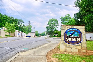
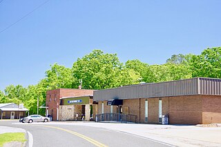
Salem is a U.S. town in Oconee County, South Carolina. The population was 135 at the 2010 United States Census.

<span class="mw-page-title-main">Walhalla, South Carolina</span> City in South Carolina, United States

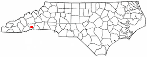
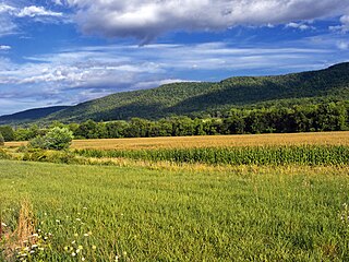
Walhalla is a city in the foothills of the Blue Ridge Mountains in Oconee County, South Carolina. Designated in 1868 as the county seat, it lies within the area of the Blue Ridge Escarpment, an area of transition between mountains and piedmont, and contains numerous waterfalls. It is located 16 miles (26 km) from Clemson University in Clemson, South Carolina.

<span class="mw-page-title-main">Lockhart, South Carolina</span> Town in South Carolina, United States

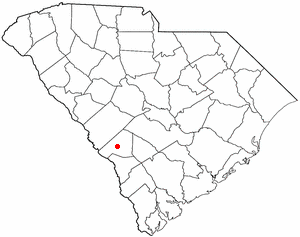
Lockhart is a town in Union County, South Carolina, United States. The population was 488 at the 2010 United States Census.

References

  1. "ArcGIS REST Services Directory". United States Census Bureau. Retrieved October 15, 2022.
  2. 1 2 U.S. Geological Survey Geographic Names Information System: West Union, South Carolina
  3. 1 2 "Census Population API". United States Census Bureau. Retrieved October 15, 2022.
  4. 1 2 "U.S. Census website". United States Census Bureau . Retrieved January 31, 2008.
  5. "US Gazetteer files: 2010, 2000, and 1990". United States Census Bureau. February 12, 2011. Retrieved April 23, 2011.
  6. "Census of Population and Housing". Census.gov. Retrieved June 4, 2015.