Morven, North Carolina

Last updated

Morven, North Carolina
NCMap-doton-Morven.PNG
Location of Morven, North Carolina
Coordinates: 34°51′52″N80°00′00″W / 34.86444°N 80.00000°W / 34.86444; -80.00000
Country United States
State North Carolina
County Anson
Founded1823 [1]
Incorporated1883 [1]
Named for Morven, Scotland [1]
Area
[2]
  Total1.03 sq mi (2.66 km2)
  Land1.03 sq mi (2.66 km2)
  Water0.00 sq mi (0.00 km2)
Elevation
[3]
345 ft (105 m)
Population
 (2020)
  Total329
  Density320.35/sq mi (123.68/km2)
Time zone UTC-5 (Eastern (EST))
  Summer (DST) UTC-4 (EDT)
ZIP code
28119
Area code 704
FIPS code 37-44560 [4]
GNIS feature ID2406199 [3]

Morven is a town in Anson County, North Carolina, United States. The population was 329 at the 2020 census. [5] The town was named after a town in Argyllshire, Scotland. [6]

Contents

Geography

According to the United States Census Bureau, the town has a total area of 1.0 square mile (2.7 km2), all land.

Morven is located on US Highway 52.

Demographics

Historical population
CensusPop.Note
1900 447
1910 49811.4%
1920 63126.7%
1930 590−6.5%
1940 6022.0%
1950 601−0.2%
1960 518−13.8%
1970 5628.5%
1980 76536.1%
1990 590−22.9%
2000 579−1.9%
2010 511−11.7%
2020 329−35.6%
2021 (est.)334 [5] 1.5%
U.S. Decennial Census [7] [8]

As of the census [4] of 2000, there were 579 people, 207 households, and 148 families residing in the town. The population density was 534.1 inhabitants per square mile (206.2/km2). There were 249 housing units at an average density of 229.7 per square mile (88.7/km2). The racial makeup of the town was 22.45% White, 76.86% African American, 0.35% Native American, 0.35% from other races. Hispanic or Latino of any race were 0.35% of the population.

There were 207 households, out of which 37.7% had children under the age of 18 living with them, 35.7% were married couples living together, 30.4% had a female householder with no husband present, and 28.5% were non-families. 25.1% of all households were made up of individuals, and 13.0% had someone living alone who was 65 years of age or older. The average household size was 2.80 and the average family size was 3.37.

In the town, the population was spread out, with 34.0% under the age of 18, 9.2% from 18 to 24, 26.1% from 25 to 44, 18.0% from 45 to 64, and 12.8% who were 65 years of age or older. The median age was 30 years. For every 100 females, there were 72.8 males. For every 100 females age 18 and over, there were 69.0 males.

The median income for a household in the town was $23,333, and the median income for a family was $30,000. Males had a median income of $27,000 versus $17,344 for females. The per capita income for the town was $9,923. About 24.2% of families and 24.9% of the population were below the poverty line, including 33.3% of those under age 18 and 17.1% of those age 65 or over.

Notable people

Related Research Articles

<span class="mw-page-title-main">Silver Lake, Indiana</span> Town in Indiana, United States

Silver Lake is a town in Lake Township, Kosciusko County, in the U.S. state of Indiana. The population was 915 at the 2010 census.

<span class="mw-page-title-main">Hazleton, Iowa</span> City in Iowa, United States

Hazleton is a city in Buchanan County, Iowa, United States. The population was 713 at the time of the 2020 census.

<span class="mw-page-title-main">Castle Hill, Maine</span> Town in the state of Maine, United States

Castle Hill is a town in Aroostook County, Maine, United States. The population was 373 people at the 2020 census.

<span class="mw-page-title-main">Green Level, North Carolina</span> Town in North Carolina, United States

Green Level is a town in Alamance County, North Carolina, United States. It is part of the Burlington, North Carolina Metropolitan Statistical Area. As of the 2020 census, the population was 3,156.

<span class="mw-page-title-main">Mount Pleasant, North Carolina</span> Town in North Carolina, United States

Mount Pleasant is a town located in eastern Cabarrus County, North Carolina, United States. As of the 2010 census, the town population was 1,652. The town center is located at the crossroads of Mount Pleasant Road and North Carolina Highway 73. NC Highway 49 skirts the town to the north on its way from Charlotte to Asheboro.

<span class="mw-page-title-main">Indian Beach, North Carolina</span> Town in North Carolina, United States

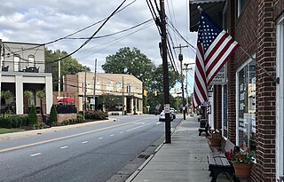
Indian Beach is a town in Carteret County, North Carolina, United States. The population was 223 as of the 2020 census.

<span class="mw-page-title-main">Earl, North Carolina</span> Town in North Carolina, United States

Earl is a town in Cleveland County, North Carolina, United States. The population was 260 at the 2010 census.

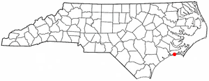
Cerro Gordo is a town in Columbus County, North Carolina, United States. The population was 207 at the 2010 census.

<span class="mw-page-title-main">Stanley, North Carolina</span> Town in North Carolina, United States

Stanley is a town in Gaston County, North Carolina, United States. The population was 3,556 at the 2010 census.

<span class="mw-page-title-main">Fountain, North Carolina</span> Town in North Carolina, United States

Fountain is a town in Pitt County, North Carolina, United States. The population was 427 at the 2010 census. The town is a part of the Greenville Metropolitan Area located in North Carolina's Inner Banks region.

<span class="mw-page-title-main">Rowland, North Carolina</span> Town in North Carolina, United States

Rowland is a town in Rowland Township, Robeson County, North Carolina, United States. The population was 1,037 at the 2010 census.

<span class="mw-page-title-main">Spencer, North Carolina</span> Town in North Carolina, United States

Spencer is a town in Rowan County, North Carolina, United States, incorporated in 1905. As of the 2010 census, the town population was 3,267.

<span class="mw-page-title-main">Stantonsburg, North Carolina</span> Town in North Carolina, United States

Stantonsburg is a town in Wilson County, North Carolina, United States. It is named for James Stanton V. The population was 784 at the 2010 census.

<span class="mw-page-title-main">McGuffey, Ohio</span> Village in Ohio, United States

McGuffey is a village in Hardin County, Ohio, United States. The population was 466 at the 2020 census.

<span class="mw-page-title-main">Rutland Township, Pennsylvania</span> Township in Pennsylvania, United States

Rutland Township is a township in Tioga County, Pennsylvania, United States. The population was 776 at the 2020 census.

<span class="mw-page-title-main">Hilda, South Carolina</span> Town in South Carolina, United States

Hilda is a town in Barnwell County, South Carolina, United States. The population was 447 at the 2010 census..

<span class="mw-page-title-main">Great Falls, South Carolina</span> Town in South Carolina, United States

Great Falls is a town in Chester County, South Carolina, United States and is located fourteen miles southwest of Lancaster, South Carolina. The population was 1,951 at the 2020 census.

<span class="mw-page-title-main">Chesterfield, South Carolina</span> Town in South Carolina, United States

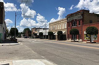
Chesterfield is a town in Chesterfield County, South Carolina, United States. The population was 1,472 at the 2010 census. It is the county seat of Chesterfield County. At the time of the 2010 census, Chesterfield was the least populous of all of South Carolina's county seats.

<span class="mw-page-title-main">Cairo, West Virginia</span> Town in West Virginia, United States

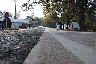
Cairo is a town in Ritchie County, West Virginia, United States, along West Virginia Route 31, the North Fork of the Hughes River, and the North Bend Rail Trail. The population was 174 at the 2020 census.

<span class="mw-page-title-main">Smyrna, South Carolina</span> Town in South Carolina, United States

Smyrna is a small town in York and Cherokee counties in the U.S. state of South Carolina. The population was 45 at the 2010 United States Census,..

References

  1. 1 2 3 "North Carolina Gazetteer" . Retrieved December 19, 2022.
  2. "ArcGIS REST Services Directory". United States Census Bureau. Retrieved September 20, 2022.
  3. 1 2 U.S. Geological Survey Geographic Names Information System: Morven, North Carolina
  4. 1 2 "U.S. Census website". United States Census Bureau . Retrieved January 31, 2008.
  5. 1 2 "City and Town Population Totals: 2020-2021". Census.gov. US Census Bureau. Retrieved July 10, 2022.
  6. "History of the name of "Morven"". The Plow Boy. Wadesboro, North Carolina. February 26, 1896. p. 3.
  7. "Census of Population and Housing". Census.gov. Retrieved June 4, 2015.
  8. "Census of Population and Housing". Census.gov. Retrieved June 4, 2016.