Peachland, North Carolina

Last updated

Peachland, North Carolina
NCMap-doton-Peachland.PNG
Location of Peachland, North Carolina
Coordinates: 34°59′35″N80°15′57″W / 34.99306°N 80.26583°W / 34.99306; -80.26583
Country United States
State North Carolina
County Anson
Incorporated1895 [1]
Named for A large peach orchard [1]
Area
[2]
  Total1.01 sq mi (2.61 km2)
  Land1.01 sq mi (2.61 km2)
  Water0.00 sq mi (0.00 km2)
Elevation
[3]
463 ft (141 m)
Population
 (2020)
  Total390
  Density386.90/sq mi (149.39/km2)
Time zone UTC-5 (Eastern (EST))
  Summer (DST) UTC-4 (EDT)
ZIP code
28133
Area code 704
FIPS code 37-50820 [4]
GNIS feature ID2407085 [3]
Website www.townofpeachland.org

Peachland is a town in Anson County, North Carolina, United States. The population was 390 at the 2020 census. [5]

Contents

History

The Barrett-Faulkner House was listed on the National Register of Historic Places in 2012. [6]

Geography

According to the United States Census Bureau, the town has a total area of 1.0 square mile (2.6 km2), all land.

Peachland is located on U.S. Route 74, a four-lane divided highway that enters the city limits, but bypasses Peachland's business district. Since US 74 does not pass through any business or residential areas, its speed limit is 55 miles per hour (89 km/h) even within the city limits.

Demographics

Historical population
CensusPop.Note
1890 58
1900 156169.0%
1910 23248.7%
1920 196−15.5%
1930 2033.6%
1940 39092.1%
1950 48524.4%
1960 56316.1%
1970 556−1.2%
1980 506−9.0%
1990 384−24.1%
2000 55444.3%
2010 437−21.1%
2020 390−10.8%
2021 (est.)402 [5] 3.1%
U.S. Decennial Census [7]

As of the census [4] of 2000, there were 554 people, 198 households, and 152 families residing in the town. The population density was 561.4 inhabitants per square mile (216.8/km2). There were 213 housing units at an average density of 215.8 per square mile (83.3/km2). The racial makeup of the town was 65.88% White, 31.23% African American, 0.54% Native American, 0.18% Pacific Islander, 0.54% from other races, and 1.62% from two or more races. Hispanic or Latino of any race were 1.99% of the population.

There were 198 households, out of which 33.3% had children under the age of 18 living with them, 51.0% were married couples living together, 19.7% had a female householder with no husband present, and 23.2% were non-families. 22.7% of all households were made up of individuals, and 11.1% had someone living alone who was 65 years of age or older. The average household size was 2.80 and the average family size was 3.26.

In the town, the population was spread out, with 28.2% under the age of 18, 8.7% from 18 to 24, 27.6% from 25 to 44, 20.2% from 45 to 64, and 15.3% who were 65 years of age or older. The median age was 34 years. For every 100 females, there were 87.8 males. For every 100 females age 18 and over, there were 93.2 males.

The median income for a household in the town was $28,250, and the median income for a family was $31,923. Males had a median income of $29,773 versus $21,346 for females. The per capita income for the town was $12,607. About 20.7% of families and 26.5% of the population were below the poverty line, including 38.3% of those under age 18 and 11.6% of those age 65 or over.

Related Research Articles

<span class="mw-page-title-main">Morven, North Carolina</span> Town in North Carolina, United States

Morven is a town in Anson County, North Carolina, United States. The population was 329 at the 2020 census. The town was named after a town in Argyllshire, Scotland.

<span class="mw-page-title-main">East Arcadia, North Carolina</span> Town in North Carolina, United States

East Arcadia is a town in Bladen County, North Carolina, United States. The population was 487 at the 2010 census.

Carolina Shores is a town in Brunswick County, North Carolina, United States. The population was 3,048 at the 2010 census, up from 1,482 in 2000. It is part of the Wilmington, NC Metropolitan Statistical Area.

<span class="mw-page-title-main">Bridgeton, North Carolina</span> Town in North Carolina, United States

Bridgeton is a town in Craven County, North Carolina, United States. The population was 454 at the 2010 census. It is part of the New Bern, North Carolina Micropolitan Statistical Area.

<span class="mw-page-title-main">Wade, North Carolina</span> Town in North Carolina, United States

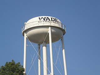
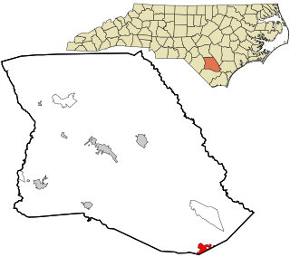
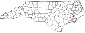
Wade is a town in Cumberland County, North Carolina, United States. The population was 556 at the 2010 census.

<span class="mw-page-title-main">Bayboro, North Carolina</span> Town in North Carolina, United States

Bayboro is a town in Pamlico County, North Carolina, United States. The population was 1,161 at the 2020 U.S. census. It is the county seat of Pamlico County.

<span class="mw-page-title-main">Mesic, North Carolina</span> Town in North Carolina, United States

Mesic is a town in Pamlico County, North Carolina, United States. The population was 220 at the 2010 census. It is part of the New Bern, North Carolina Micropolitan Statistical Area.

<span class="mw-page-title-main">Stonewall, North Carolina</span> Town in North Carolina, United States

Stonewall is a town in Pamlico County, North Carolina, United States. The population was 281 at the 2010 census. It is part of the New Bern, North Carolina Micropolitan Statistical Area.

<span class="mw-page-title-main">Donalds, South Carolina</span> Town in South Carolina, United States

Donalds is a town in Abbeville County, South Carolina. As of the 2020 United States Census, its population was 328.

Ulmer is a town in Allendale County, South Carolina, United States. The population was 65 at the 2020 census.

<span class="mw-page-title-main">Meggett, South Carolina</span> Town in South Carolina, United States

Meggett is a town in Charleston County, South Carolina, United States. The population was 1,226 at the 2010 census. Meggett is part of the Charleston-North Charleston-Summerville metropolitan area.

<span class="mw-page-title-main">Great Falls, South Carolina</span> Town in South Carolina, United States

Great Falls is a town in Chester County, South Carolina, United States and is located fourteen miles southwest of Lancaster, South Carolina. The population was 1,951 at the 2020 census.

<span class="mw-page-title-main">Arcadia Lakes, South Carolina</span> Town in South Carolina, United States

Arcadia Lakes is a town in Richland County, South Carolina, United States. The population was 861 at the 2010 census. It is part of the Columbia, South Carolina, Metropolitan Statistical Area.

<span class="mw-page-title-main">Ridgeway, Virginia</span> Town in Virginia, United States

Ridgeway is a town in Henry County, Virginia, United States. The population was 742 at the 2010 census. It is part of the Martinsville Micropolitan Statistical Area. Martinsville Speedway, a NASCAR racetrack, is located between Ridgeway and the Martinsville city limits.

<span class="mw-page-title-main">Durbin, West Virginia</span> Town in West Virginia, United States

Durbin is a town in Pocahontas County, West Virginia, United States. The population was 235 at the 2020 census.

<span class="mw-page-title-main">Reedy, West Virginia</span> Town in West Virginia, United States

Reedy is a town in Roane County, West Virginia, United States. The population was 152 at the 2020 census.

<span class="mw-page-title-main">Worden, Wisconsin</span> Town in Wisconsin, United States

Worden is a town in Clark County in the U.S. state of Wisconsin. The population was 657 at the 2000 census.

<span class="mw-page-title-main">Glen Haven, Wisconsin</span> Town in Wisconsin, United States

Glen Haven is a town in Grant County, Wisconsin, United States. According to the 2000 census, the town population was 490. The census-designated place of Glen Haven is located in the town.

<span class="mw-page-title-main">Helvetia, Wisconsin</span> Town in Wisconsin, United States

Helvetia is a town in Waupaca County, Wisconsin, in the United States. As of the 2000 census, the town population was 649.

Plainfield is a town in Waushara County, Wisconsin, United States. The population was 533 at the 2000 census. The village of Plainfield is surrounded by the town. The ghost town of West Plainfield is located in the town.

References

  1. 1 2 "North Carolina Gazetteer" . Retrieved December 19, 2022.
  2. "ArcGIS REST Services Directory". United States Census Bureau. Retrieved September 20, 2022.
  3. 1 2 U.S. Geological Survey Geographic Names Information System: Peachland, North Carolina
  4. 1 2 "U.S. Census website". United States Census Bureau . Retrieved January 31, 2008.
  5. 1 2 "City and Town Population Totals: 2020-2021". Census.gov. US Census Bureau. Retrieved July 10, 2022.
  6. "National Register of Historic Places Listings". Weekly List of Actions Taken on Properties: 9/04/12 through 9/07/12. National Park Service. September 14, 2012.
  7. "Census of Population and Housing". Census.gov. Retrieved June 4, 2016.