Beauregard, Mississippi

Last updated

Beauregard, Mississippi
Copiah County Mississippi Incorporated and Unincorporated areas Beauregard Highlighted.svg
Location of Beauregard, Mississippi
Coordinates: 31°43′18″N90°23′17″W / 31.72167°N 90.38806°W / 31.72167; -90.38806
Country United States
State Mississippi
County Copiah
Area
[1]
  Total0.92 sq mi (2.39 km2)
  Land0.92 sq mi (2.37 km2)
  Water0.01 sq mi (0.02 km2)
Elevation
463 ft (141 m)
Population
 (2020)
  Total289
  Density315.50/sq mi (121.82/km2)
Time zone UTC-6 (Central (CST))
  Summer (DST) UTC-5 (CDT)
FIPS code 28-04540
GNIS feature ID0666684

Beauregard is a village in Copiah County, Mississippi, United States. The population was 326 at the 2010 census. [2] It is part of the Jackson Metropolitan Statistical Area. Beauregard is named for P. G. T. Beauregard. [3]

Contents

Geography

Beauregard is located in southern Copiah County at 31°43′18″N90°23′17″W / 31.72167°N 90.38806°W / 31.72167; -90.38806 (31.721549, -90.388096). [4] It is bordered to the south by the town of Wesson. U.S. Route 51 passes along the western edge of the village, leading north 10 miles (16 km) to Hazlehurst, the county seat, and south 10 miles (16 km) to Brookhaven. Exit 51 on Interstate 55 is 4 miles (6 km) west of the village center on Sylvarena Road.

According to the United States Census Bureau, the village has a total area of 0.93 square miles (2.4 km2), of which 0.008 square miles (0.02 km2), or 0.82%, is water. [2]

Demographics

Historical population
CensusPop.Note
1870 315
1880 51764.1%
1900 338
1910 240−29.0%
1920 173−27.9%
1930 20317.3%
1940 2239.9%
1950 2313.6%
1960 193−16.5%
1970 1993.1%
1980 185−7.0%
1990 20611.4%
2000 26528.6%
2010 32623.0%
2020 289−11.3%
U.S. Decennial Census [5]

2020 census

Beauregard, Mississippi – Racial and ethnic composition
Note: the US Census treats Hispanic/Latino as an ethnic category. This table excludes Latinos from the racial categories and assigns them to a separate category. Hispanics/Latinos may be of any race.
Race / Ethnicity (NH = Non-Hispanic)Pop 2000 [6] Pop 2010 [7] Pop 2020 [8] % 2000% 2010% 2020
White alone (NH)12318616646.42%57.06%57.44%
Black or African American alone (NH)14213110453.58%40.18%35.99%
Native American or Alaska Native alone (NH)0000.00%0.00%0.00%
Asian alone (NH)0010.00%0.0%0.35%
Pacific Islander alone (NH)0010.00%0.00%0.35%
Other race alone (NH)0000.00%0.00%0.00%
Mixed Race or Multi-Racial (NH)0040.00%0.00%1.38%
Hispanic or Latino (any race)09130.00%2.76%4.50%
Total265326289100.00%100.00%100.00%

As of the census [9] of 2000, there were 265 people, 91 households, and 68 families residing in the village. The population density was 290.5 inhabitants per square mile (112.2/km2). There were 94 housing units at an average density of 103.0 per square mile (39.8/km2). The racial makeup of the village was 46.42% White and 53.58% African American.

There were 91 households, out of which 37.4% had children under the age of 18 living with them, 50.5% were married couples living together, 17.6% had a female householder with no husband present, and 24.2% were non-families. 23.1% of all households were made up of individuals, and 4.4% had someone living alone who was 65 years of age or older. The average household size was 2.91 and the average family size was 3.46.

In the village, the population was spread out, with 31.3% under the age of 18, 10.6% from 18 to 24, 28.3% from 25 to 44, 19.6% from 45 to 64, and 10.2% who were 65 years of age or older. The median age was 30 years. For every 100 females, there were 102.3 males. For every 100 females age 18 and over, there were 100.0 males.

The median income for a household in the village was $25,750, and the median income for a family was $34,063. Males had a median income of $32,344 versus $14,063 for females. The per capita income for the village was $11,671. About 15.5% of families and 19.8% of the population were below the poverty line, including 15.1% of those under the age of eighteen and 7.4% of those 65 or over.

Education

Beauregard is served by the Copiah County School District.

Notable person

Related Research Articles

<span class="mw-page-title-main">Pike County, Alabama</span> County in Alabama, United States

Pike County is located in the U.S. state of Alabama. As of the 2020 census the population was 33,009. Its county seat is Troy. Its name is in honor of General Zebulon Pike, of New Jersey, who led an expedition to southern Colorado and encountered Pikes Peak in 1806.

<span class="mw-page-title-main">Lincoln County, Mississippi</span> County in Mississippi, United States

Lincoln County is a county located in the U.S. state of Mississippi. As of the 2020 census, the population was 34,907. Its county seat is Brookhaven.

<span class="mw-page-title-main">Deer Park, Illinois</span> Village in Illinois, United States

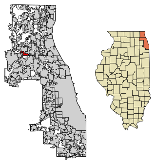
Deer Park is a village in Lake and Cook Counties, Illinois. Per the 2020 census, the population was 3,681. The village is one of the few left in the Chicago area that enjoy a green belt which is bordered by two large natural areas providing outdoor recreation and open space. The village is home to popular shopping and dining destinations: Deer Park Town Center and the Town Center Promenade. The town is also home to the Vehe Farm, an Illinois Centennial Farm.

<span class="mw-page-title-main">Thornton, Illinois</span> Village in Illinois, United States

Thornton is a village in Cook County, Illinois, United States and a south suburb of Chicago. The population was 2,386 at the 2020 census. Thornton is home to the Thornton Quarry, one of the largest quarries in the world.

<span class="mw-page-title-main">Pingree Grove, Illinois</span> Village in Illinois, United States

Pingree Grove is a village in Kane County, Illinois, United States. The population was 124 at the 2000 census. However, with rapid development in the following years, the 2010 census indicated 4,532 residents, and the 2020 census was 10,365.

<span class="mw-page-title-main">Channel Lake, Illinois</span> Census-designated place in Illinois, United States

Channel Lake is an unincorporated community and census-designated place (CDP) in Antioch Township, Lake County, Illinois, United States. Per the 2020 census, the population was 1,581.

<span class="mw-page-title-main">Madison, Illinois</span> City in Illinois, United States

Madison is a city in Madison and St. Clair counties in the U.S. state of Illinois. The population was 3,171 at the 2020 census, down from 3,891 in 2010. It is home to World Wide Technology Raceway at Gateway and the first Bulgarian Orthodox church in the United States.

<span class="mw-page-title-main">Venice, Illinois</span> City in Illinois, United States

Venice is a city in Madison County, Illinois, United States. The population was 1,498 at the 2020 census, down from 1,890 in 2010.

<span class="mw-page-title-main">Matherville, Illinois</span> Village in Illinois, United States

Matherville is a village in Mercer County, Illinois, United States. The population was 707 at the 2020 census.

<span class="mw-page-title-main">Oak Grove, Illinois</span> Village in Illinois, United States

Oak Grove is a village in Rock Island County, Illinois, United States. The population was 476 at the time of the 2020 census; up from 396 at the 2010 census.

<span class="mw-page-title-main">Gramercy, Louisiana</span> Town in Louisiana, United States

Gramercy is a town in the U.S. state of Louisiana, in St. James Parish. It is part of the New Orleans Metropolitan Area. The population was 3,613 at the time of the 2010 U.S. census and 3,188 according to the 2020 population estimates program.

<span class="mw-page-title-main">Lutcher, Louisiana</span> Town in Louisiana, United States

Lutcher is a town in St. James Parish, Louisiana, United States, on the east bank of the Mississippi River. It is part of the New Orleans Metropolitan Area. The population was 3,559 at the 2010 U.S. census, and 3,127 at the 2020 population estimates program.

Wallace is a census-designated place (CDP) in St. John the Baptist Parish, Louisiana, United States. The population was 570 at the 2000 census. It is part of the New Orleans–Metairie–Kenner Metropolitan Statistical Area. The rural community is on the west bank of the Mississippi River and easily accessible to Interstate 10 via the Gramercy Bridge.

<span class="mw-page-title-main">Renova, Mississippi</span> Town in Mississippi, United States

Renova is a town in Bolivar County, Mississippi, United States.Per the 2020 census, the population was 676. The community was founded by African Americans and remains predominantly African American.

<span class="mw-page-title-main">Shelby, Mississippi</span> City in Mississippi, United States

Shelby is a city in Bolivar County, Mississippi, United States. The population was 2,229 at the 2010 census, down from 2,926 in 2000. The town of Shelby was established in 1853 by Tom Shelby, who had purchased a block of land there from the federal government.

<span class="mw-page-title-main">Georgetown, Mississippi</span> Town in Mississippi, United States

Georgetown is a town in Copiah County, Mississippi, United States. The population was 286 at the 2010 census. With its eastern border formed by the Pearl River, it is part of the Jackson Metropolitan Statistical Area.

<span class="mw-page-title-main">Falcon, Mississippi</span> Town in Mississippi, United States

Falcon is a town in Quitman County, Mississippi. The population was 116 at the 2020 census.

<span class="mw-page-title-main">Puckett, Mississippi</span> Village in Mississippi, United States

Puckett is a village in Rankin County, Mississippi, United States. According to the 2020 census, the population was 342. It is part of the Jackson Metropolitan Statistical Area.

<span class="mw-page-title-main">Wilson City, Missouri</span> Village in Missouri, United States

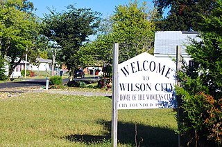
Wilson City is a village in Mississippi County, Missouri, United States. The population was 77 at the 2020 census.

<span class="mw-page-title-main">Pinhook, Missouri</span> Inactive Village in Missouri, United States

Pinhook is an inactive village in Mississippi County, Missouri, United States. The population was 6 at the 2020 census, down from 30 in 2010.

References

  1. "2020 U.S. Gazetteer Files". United States Census Bureau. Retrieved July 24, 2022.
  2. 1 2 "Geographic Identifiers: 2010 Demographic Profile Data (G001): Beauregard village, Mississippi". U.S. Census Bureau, American Factfinder. Archived from the original on February 12, 2020. Retrieved October 7, 2014.
  3. John Everett-Heath (December 7, 2017). The Concise Dictionary of World Place Names. OUP Oxford. p. 380. ISBN   978-0-19-255646-2.
  4. "US Gazetteer files: 2010, 2000, and 1990". United States Census Bureau. February 12, 2011. Retrieved April 23, 2011.
  5. "Census of Population and Housing". Census.gov. Retrieved June 4, 2015.
  6. "P004: Hispanic or Latino, and Not Hispanic or Latino by Race – 2000: DEC Summary File 1 – Beauregard village, Mississippi". United States Census Bureau. Retrieved February 25, 2024.
  7. "P2: Hispanic or Latino, and Not Hispanic or Latino by Race – 2010: DEC Redistricting Data (PL 94-171) – Beauregard village, Mississippi". United States Census Bureau. Retrieved February 25, 2024.
  8. "P2: Hispanic or Latino, and Not Hispanic or Latino by Race – 2020: DEC Redistricting Data (PL 94-171) – Beauregard village, Mississippi". United States Census Bureau. Retrieved February 25, 2024.
  9. "U.S. Census website". United States Census Bureau . Retrieved January 31, 2008.
  10. Adam Gussow (September 5, 2017). Beyond the Crossroads: The Devil and the Blues Tradition. University of North Carolina Press. p. 209. ISBN   978-1-4696-3367-1.