
The Korowai, also called the Kolufo, are the people who live in southeastern Papua in the Indonesian provinces of South Papua and Highland Papua. Specifically their tribal area is split by the borders of Boven Digoel Regency, Mappi Regency, Asmat Regency, and Yahukimo Regency. They number about 3,000 people.

The Bismarck Sea lies in the southwestern Pacific Ocean within the nation of Papua New Guinea. It is located northeast of the island of New Guinea and south of the Bismarck Archipelago. It has coastlines in districts of the Islands Region, Momase Region, and Papua Region.


The Fly River is the third longest river in the island of New Guinea, after the Sepik River and Mamberamo River, with a total length of 1,060 km (660 mi). It is the largest by volume of discharge in Oceania, the largest in the world without a single dam in its catchment, and overall the 20th-largest primary river in the world by discharge volume. It is located in the southwest of Papua New Guinea and in the South Papua province of Indonesia. It rises in the Victor Emanuel Range arm of the Star Mountains, and crosses the south-western lowlands before flowing into the Gulf of Papua in a large delta. The Fly-Strickland River system has a total length of 1,220 km (760 mi), making it the longest river system of an island in the world. The 824 km (512 mi) Strickland River is the longest and largest tributary of Fly River, making it the farthest distance source of the Fly River.

The Ok Tedi is a river in New Guinea. The Ok Tedi Mine is located near the headwaters of the river, which is sourced in the Star Mountains. It is the second largest tributary of the Fly River. Nearly the entirety of the river runs through the North Fly District of the Western Province of Papua New Guinea, but the river crosses the international boundary with Indonesia for less than one kilometre. The largest settlement of the Western Province, Tabubil is located near its banks.

Western Province is a coastal province in southwestern Papua New Guinea, bordering the Indonesian provinces of Highland Papua and South Papua. The provincial capital is Daru. The largest town in the province is Tabubil. Other major settlements are Kiunga, Ningerum, Olsobip and Balimo.
The Left May or Arai languages are a small language family of half a dozen closely related but not mutually intelligible languages in the centre of New Guinea, in the watershed of the Left May River. There are only about 2,000 speakers in all. Foley (2018) classifies them separately as an independent language family, while Usher (2020) links them with the Amto–Musan languages.

The Trans-Fly – Bulaka RiverakaSouth-Central Papuan languages form a hypothetical family of Papuan languages. They include many of the languages west of the Fly River in southern Papua New Guinea into southern Indonesian West Papua, plus a pair of languages on the Bulaka River a hundred km further west.

The Western Guinean lowland forests ecoregion is a tropical moist broadleaf forest ecoregion of West Africa. It is centered on Liberia, with portions in surrounding countries. It is the westernmost tropical rainforest in Africa, and has high levels of species endemism, with over 200 species of endemic plants.

The New Guinea Highlands, also known as the Central Range or Central Cordillera, is a long chain of mountain ranges on the island of New Guinea, including the island's tallest peak, Puncak Jaya, Indonesia, 16,024 ft (4,884 m), the highest mountain in Oceania. The range is home to many intermountain river valleys, many of which support thriving agricultural communities. The highlands run generally east-west the length of the island, which is divided politically between Indonesia in the west and Papua New Guinea in the east.
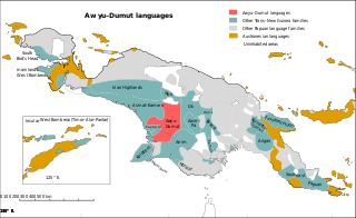
The Greater Awyu or Digul River languages, known in earlier classifications with more limited scope as Awyu–Dumut (Awyu–Ndumut), are a family of perhaps a dozen Trans–New Guinea languages spoken in eastern West Papua in the region of the Digul River. Six of the languages are sufficiently attested for a basic description; it is not clear how many of the additional names may be separate languages.

The Turama–Kikorian languages are a family identified by Arthur Capell (1962) and part of the Trans–New Guinea languages (TNG) family in the classifications of Stephen Wurm (1975) and Malcolm Ross (2005). The family is named after the Turama River and Kikori River of southern Papua New Guinea; the alternative name is based more narrowly on the Omati River.

The Chimbu–Wahgi languages are a language family sometimes included in the Trans–New Guinea proposal.

New Guinea is the world's second-largest island, with an area of 785,753 km2 (303,381 sq mi). Located in Melanesia in the southwestern Pacific Ocean, the island is separated from Australia by the 150-kilometre wide Torres Strait, though both landmasses lie on the same continental shelf. Numerous smaller islands are located to the west and east.
The Trans-Fly languages are a small family of Papuan languages proposed by Timothy Usher, that are spoken in the region of the Fly River.
Samo, also known as Daba, Nomad, and Supei, is a Trans–New Guinea language of New Guinea, spoken in the plains east of the Strickland River in Western Province of Papua New Guinea. It has switch-reference marking for the subject of a clause.
Korowai (Kolufaup) is a Trans-New-Guinean language spoken in South Papua, Indonesia. It is spoken by the Korowai people who live along the Becking River.

Tabo, also known as Waia (Waya), is a Papuan language of Western Province, Papua New Guinea, just north of the Fly River delta. The language has also been known as Hiwi and Hibaradai.
Kimki (Aipki) or Sukubatom (Sukubatong) is a South Pauwasi language of Batom District, Pegunungan Bintang Regency, Papua, Indonesia. Foley classifies Kimki as a language isolate, although he notes some similarities with Murkim. Usher demonstrates a connection to the other South Pauwasi languages.
