Mamberamo River

Last updated
Mamberamo
Sungai Mamberamo.jpg
Mamberamo River, aerial view in 2017.
Mamberamo River NASA.jpg
Mamberamo, entering the sea, seen from space.
Location
Country Indonesia
Region Papua
Physical characteristics
Sourceconfluence of Tariku and Taritatu
  coordinates 2°55′30″S138°26′30″E / 2.92500°S 138.44167°E / -2.92500; 138.44167
Mouth  
  location
Pacific Ocean, Indonesian, New Guinea
  coordinates
1°28′S137°54′E / 1.467°S 137.900°E / -1.467; 137.900
  elevation
0 m (0 ft)
Length1,112 km (691 mi)
Basin size78,992 km2 (30,499 sq mi) [1]
Depth 
  minimum8 m (26 ft)
  maximum33 m (108 ft)
Discharge 
  locationMamberamo Delta, Pacific Ocean
  average5,500 m3/s (190,000 cu ft/s) [2] 5,922.9 m3/s (209,170 cu ft/s) [3]
  maximum25,000 m3/s (880,000 cu ft/s)
Basin features
Tributaries 
  left Tariku River
  right Taritatu River

The Mamberamo (Indonesian: Sungai Mamberamo) is the second-longest river on the island of New Guinea, after Sepik River (1,146 km) and third largest in Oceania by discharge (5,500 m3/s) volume after Fly River (7,500 m3/s) and Sepik (7,000 m3/s). It is located in the Indonesian province of Papua. It is the second largest river in Indonesia by volume of discharge after Kapuas River (6,500 m3/s) and also the widest. [4]

Contents

The river is formed from the confluence of its upper tributaries, the Tariku and Taritatu rivers in the Lakes Plains region, an interior basin with extensive freshwater swamp forests and grasslands. It flows northwards between the Van Rees Range (Pegunungan Van Rees) and Foja Mountains through a series of rapids and gorges. The last 160 km of the river are navigable. [5] In the coastal lowlands the river is lined with marshes and forms a broad river delta. The Mamberamo discharges into the Pacific Ocean at the northern point of Point D'Urville or Cape Narwaku (Tanjung Narwaku).

The river's huge valley is home to various uncontacted peoples and incredible biodiversity. In the 1990s, the Indonesian Government had plans to construct a large hydroelectric dam on the Mamberamo that would have submerged much of the area. This plan was shelved after the Indonesian financial crisis from 1998–1999, but there are concerns by environmental groups that it could be resurrected sometime in the future. At present, the Mamberamo remains the second largest river in the world to be completely unfragmented by dams in its catchment, behind only the relatively nearby Fly. [4]

The Mamberamo area also broadly refers to several nearby mountain ranges, including the Van Rees and Foja Mountains (also known as Foya), which were the subject of a recent rapid biological assessment conducted by Conservation International, the Indonesian Institute of Sciences, and Cenderawasih University. The scientific team discovered the first new bird species from New Guinea in 60 years, and a wealth of other new plants and animals. The Foya Mountains appear to be a globally outstanding repository of biodiversity.

Tributary

Mamberamo River List of Tributaries by length.

History

The upper Mamberamo River photographed during the Central-North New Guinea Expedition led by Le Roux COLLECTIE TROPENMUSEUM Het stroomgebied van de boven Mamberano in Nieuw Guinea waar het explorateurs bivak ligt TMnr 10020882.jpg
The upper Mamberamo River photographed during the Central-North New Guinea Expedition led by Le Roux

In 1545, the Spanish navigator Iñigo Ortiz de Retes sailed along the northern coast of the island as far as the mouth of this river that he charted as San Agustín. At this spot, on 20 June 1545, he claimed the territory for the Spanish Crown, and in the process bestowing the name to the island (Nueva Guinea) by which it is known today.

The first European to enter the mouth of the Mamberamo was Dutchman Dr D. F. van Braam Morris in 1883. The resident from the northern Moluccas (Ternate) rowed up the river to ascertain that it was navigable by steamer. [6] The following year in 1884 Van Braam Morris returned in the steamship Havik and travelled 60 mi (97 km) (as the crow flies) along its course. [7]

The Mamberamo River in 2017 Sungai Mamberamo.jpg
The Mamberamo River in 2017

Mamberamo Foja Wildlife Reserve

The Mamberamo Foja Wildlife Reserve covers an area of 16,610 km², extending along the Mamberamo and its major tributaries from the Central Range foothills to the Pacific Ocean. It encompasses the central Lakes Plains region, and extends southwards along the eastern side of the river to include the Foya Mountains, the river delta, and the sea. [8]

Mamberamo Bridge

The Mamberamo Bridge was the second longest cable stayed span in Indonesia after Kutai Kartanegara Bridge with 235 meters and 270 meters respectively until the latter bridge collapsed in November 2011.

See also

Related Research Articles

<span class="mw-page-title-main">Ogooué River</span> River in Gabon, Africa

The Ogooué, also known as the Nazareth River, some 1,200 kilometres (750 mi) long, is the principal river of Gabon in west-central Africa and the fifth largest river in Africa by volume of discharge, trailing only the Congo, Kasai, Niger and Zambezi. Its watershed drains nearly the entire country of Gabon, with some tributaries reaching into the Republic of the Congo, Cameroon, and Equatorial Guinea.

<span class="mw-page-title-main">Fly River</span> River in Papua New Guinea

The Fly River is the third longest river in the island of New Guinea, after the Sepik River and Mamberamo River, with a total length of 1,060 km (660 mi). It is the largest by volume of discharge in Oceania, the largest in the world without a single dam in its catchment, and overall the 20th-largest primary river in the world by discharge volume. It is located in the southwest of Papua New Guinea and in the South Papua province of Indonesia. It rises in the Victor Emanuel Range arm of the Star Mountains, and crosses the south-western lowlands before flowing into the Gulf of Papua in a large delta. The Fly-Strickland River system has a total length of 1,220 km (760 mi), making it the longest river system of an island in the world. The 824 km (512 mi) Strickland River is the longest and largest tributary of Fly River, making it the farthest distance source of the Fly River.

<span class="mw-page-title-main">Ramu</span> Major river in Papua New Guinea

The Ramu River is a major river in northern Papua New Guinea. The headwaters of the river are formed in the Kratke Range from where it then travels about 640 km (398 mi) northwest to the Bismarck Sea.

<span class="mw-page-title-main">Purari River</span> River in Papua New Guinea

The Purari is a river that originates in the south central highlands especially in Kandep District of Enga Province of Papua New Guinea, flowing 630 kilometres (391 mi) though Gulf Province to the Gulf of Papua. The Purari has a 33,670 km2 (13,000 sq mi) drainage basin and is the third largest river in Papua New Guinea. The discharge varies through the year, averaging around 3,000 m3/s (110,000 cu ft/s)–4,000 m3/s (140,000 cu ft/s) at the delta.

<span class="mw-page-title-main">Foja Mountains</span> Mountain range in Indonesia

The Foja Mountains are located just north of the Mamberamo river basin in Papua, Indonesia. The mountains rise to 2,193 metres (7,195 ft), and have 3,000 square kilometers of old growth tropical rainforest in the interior part of the range. The Foja forest tract covers 9,712 square kilometers and is the largest tropical forest without roads in the Asia Pacific region.

<span class="mw-page-title-main">Digul</span> River in Indonesia

The Digul River is a major river in southern Papua province, Indonesia, on the island of New Guinea. It is the fourth longest river in New Guinea after Sepik River, Mamberamo River and Fly River. With a total length of 853 km (530 mi) and has a drainage basin of 45,900 km2 (17,700 sq mi).

<span class="mw-page-title-main">Northern New Guinea lowland rain and freshwater swamp forests</span> Ecoregion in New Guinea

The Northern New Guinea lowland rain and freshwater swamp forests is a tropical moist broadleaf forest ecoregion of northern New Guinea.

<span class="mw-page-title-main">New Guinea</span> Island in the Pacific Ocean

New Guinea is the world's second-largest island, with an area of 785,753 km2 (303,381 sq mi). Located in Melanesia in the southwestern Pacific Ocean, the island is separated from Australia by the 150-kilometre wide Torres Strait, though both landmasses lie on the same continental shelf, and were united during episodes of low sea level in the Pleistocene glaciations as the combined landmass of Sahul. Numerous smaller islands are located to the west and east. The island's name was given by Spanish explorer Yñigo Ortiz de Retez during his maritime expedition of 1545 due to the resemblance of the indigenous peoples of the island to those in the African region of Guinea.

The Tariku or Rouffaer River is a river in the northern part of the Indonesian province of Papua. It is one of the major tributary of Mamberamo River with a total length of 488 km (303 mi).

The Taritatu or Idenburg River also called Baliem River is a river in the northern part of the Indonesian province of Papua. It is the largest tributary of Mamberamo River with a total length of 808 km (502 mi).

<span class="mw-page-title-main">Kapuas River (Barito River tributary)</span> River in Indonesia

The Kapuas River is a river in the Indonesian part of Borneo island. It originates in the Müller Mountain Range at the center of the island and flows south until merging with the Barito River and discharging into the Java Sea. It should be distinguished from another Kapuas River, which starts on the other side of the same mountain range in central Borneo, but flows to the west and empties to the South China Sea.

<span class="mw-page-title-main">Sepik</span> River on New Guinea

The Sepik is the longest river on the island of New Guinea, and the second largest in Oceania by discharge volume after the Fly River. The majority of the river flows through the Papua New Guinea (PNG) provinces of Sandaun and East Sepik, with a small section flowing through the Indonesian province of Papua.

Oreophryne furu is a species of microhylid frogs endemic to the Mamberamo River basin in Papua, Western New Guinea. It is distinguished from other related species by its small size, unique call and egg-guarding behaviour.

<span class="mw-page-title-main">Yuat River</span> River in Papua New Guinea

The Yuat is the major tributary of the Sepik River in northern Papua New Guinea. The Yuat is on the right (southern) side and joins the Sepik about 20 linear km upstream from the Keram River, and just downstream from the Chambri Lakes. The eponymous (Middle) Yuat and Upper Yuat languages are spoken along the banks of the Yuat River.

<span class="mw-page-title-main">Lakes Plains</span>

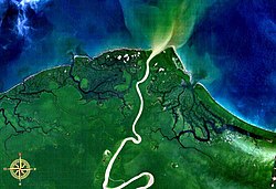
The Mamberamo Lakes Plains are a large, flat low-lying area of the Mamberamo River basin in the Indonesian province Papua on the island of New Guinea. The plain is defined by the meandering tributaries of the Mamberamo, and includes hundreds of oxbow lakes. It is 300 kilometers long and about 50 kilometers wide, and is entirely enclosed by mountains apart from the outlet of the Mameramo. It is inhabited in the west, but the eastern lobe is largely uninhabited.

<span class="mw-page-title-main">Northern New Guinea montane rain forests</span> Ecoregion in New Guinea

The Northern New Guinea montane rain forests is a tropical moist forest ecoregion in northern New Guinea. The ecoregion covers several separate mountain ranges lying north of New Guinea's Central Range and south of the Pacific Ocean.

<span class="mw-page-title-main">Mamberamo Foja Wildlife Reserve</span>

Mamberamo Foja Wildlife Reserve is a large protected area on New Guinea, in Indonesia's Papua Province. It covers an area of 16,610 km2, and extends along the Mamberamo River and its tributaries from the foothills of the Central Range to the Pacific Ocean.

References

  1. Joesron, Loebis. "Country Report Implementation of Demonstration Project Mamberamo River Basin INDONESIA".
  2. Joesron, Loebis. "Country Report Implementation of Demonstration Project Mamberamo River Basin INDONESIA".
  3. Rendy, Firmansyah. "Grafik Neraca Air Pulau Papua".
  4. 1 2 "Fragmentation and Flow Regulation of the World's Large River Systems" (PDF). Archived from the original (PDF) on 2012-03-30. Retrieved 2013-01-12.
  5. "Mamberamo River". Encyclopaedia Britannica. Accessed 7 June 2020
  6. Souter (1963) p. 145
  7. (in Dutch) 'Nieuw Guinea', in de De Locomotief, donderdag 5 maart 1885 no. 57. Visited 2 July 2013
  8. Petocz, Ronald G. (1989). Conservation and Development in Irian Jaya: A Strategy for Rational Resource Utilization. Brill, 1989.