
Leicester is a city, unitary authority area, unparished area and the county town of Leicestershire in the East Midlands of England. It is the largest city in the East Midlands. Its population was 368,600 in 2021, increased by 38,800 from around 329,800 in 2011. The greater Leicester urban area had a population of 559,017 in 2021, making it the 11th most populous in England, and the 13th most populous in the United Kingdom.

Wigston, or Wigston Magna, is a town and unparished area in the Oadby and Wigston district, in Leicestershire, England, just south of Leicester on the A5199. It had a population of 32,321 in 2011.

Leicester railway station is a mainline railway station in the city of Leicester in Leicestershire, England. The station is managed by East Midlands Railway and owned by Network Rail. The station is served by CrossCountry and East Midlands Railway services.
Evington is an area of Leicester, and electoral ward of the Leicester district, in the ceremonial county of Leicestershire, England. It used to be a small village centred on Main Street and the Anglican church of St Denys but was close enough to Leicester to become one of the outer suburbs in the 1930s. Today, the ward comprises the historical village of Evington, as well as the modern ex-council estates of Rowlatts Hill and Goodwood. The population of the ward at the 2011 census was 11,133.

Ballymun is an outer suburb of Dublin, Ireland, at the northern edge of the Northside, the green-field development of which began in the 1960s to accommodate a housing crisis in inner city areas of Dublin. While the newly built housing was state-of-the-art at the time, comprising high-rise tower blocks and flat complexes, residents were moved in years before shops, schools and other infrastructure were fully ready, and the area became well known for both a strong community spirit and considerable social challenges. Ballymun has several sub-districts such as Sillogue, Coultry, Shangan and Poppintree, and is close to both the Republic of Ireland's only IKEA store and to Dublin Airport. The area is the source of one Dublin river, and parts lie in the floodplain of another, and there are a number of parks.
Moss Side is an inner-city area of Manchester, England, 1.9 miles (3.1 km) south of the city centre, It had a population of 20,745 at the 2021 census. Moss Side is bounded by Hulme to the north, Chorlton-on-Medlock, Rusholme and Fallowfield to the east, Whalley Range to the south, and Old Trafford to the west.

City ward — which includes the districts of Highfield, Kelham Island and the city centre — is one of the 28 electoral wards in City of Sheffield, England. It covers the central area of the city. The ward was created following the 2015 local government boundary review out of part of the old Central ward, which, with a population of 36,412, was the largest ward in the UK. City is one of the wards that make up the Sheffield Central constituency.
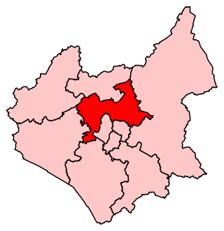
Charnwood is a constituency in Leicestershire represented in the House of Commons of the UK Parliament since 2015 by Edward Argar, a Conservative.
Whitmore Reans is in Wolverhampton, West Midlands, England. It is situated to the north-west of the city centre, in the city council's Park and St Peter's wards.
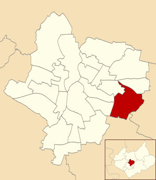
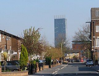
Leicester City Centre is Leicester's historical commercial, cultural and transport hub and is home to its central business district. Its inner core is roughly delineated by the A594, Leicester's inner ring road, although the various central campuses of the University of Leicester, De Monfort University and Leicester College are adjacent to the inner ring road and could be considered to be a continuation of the City centre. In a similar way, the Leicester Royal Infirmary precinct, the New Walk business district (Southfields), the Welford Road Stadium of Leicester Tigers' RUFC and the King Power Stadium of Premier League Leicester City to the south, and the Golden Mile to the north could also be deemed to be extensions to the central core.

The A594 Central Ring is the name of Leicester's central distributor road network.

Leicester Central was a railway station in Leicester, England. It was situated to the west of the city centre, on Great Central Street which is today just off the inner ring road. It was closed in 1969.

Woodgate is an area in Leicester in Fosse Ward. It lies west of the River Soar and is an important entrance to the city leading on to Frog Island. A busy junction, its northern end lies at the intersection of Fosse Road North, Groby Road, Blackbird Road and Buckminster Road. To the south is the Rally Park, which was formerly the goods yard of the London Midland Railway, which was originally the Leicester to Swannington Railway built by Robert Stephenson in 1832. To the west is Fosse Road North. At its eastern end Woodgate terminates at the North Bridge over the old River Soar.

Kelham Island is one of Sheffield's eleven designated Quarters. Formerly an industrial area, the island itself was created by the building of a goit, or mill race, fed from the River Don to serve the water wheels powering the workshops of the areas' industrial heyday. The quarter was named after the island, however, the boundaries extend beyond the physical island created by the river and goit.
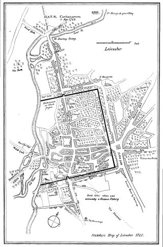
Ratae Corieltauvorum or simply Ratae was a town in the Roman province of Britannia. Today it is known as Leicester, located in the English county of Leicestershire.
Pype Hayes is a modern housing estate area in the east of the Erdington district of Birmingham. It is within the Tyburn ward. Covering the postcodes of B24 and B76.
Eyres Monsell is an electoral ward and administrative division in Leicester, England.
Westcotes is an area to the west of the city of Leicester. It is also a ward of the City of Leicester whose population at the 2011 census was 11,644. It is also known as the West End of Leicester. The area is quite small in comparison with other areas of the city, but it is well known as it has many shops, bars and restaurants and is a popular choice for students and young professionals.

The Grand Hotel is a Grade II listed large hotel on Granby Street in the City centre of Leicester, England. It is now known as the Mercure Leicester The Grand Hotel.
Keepmoat Homes Ltd is a housebuilding company in the United Kingdom that provides private homes for sale. Its headquarters are in Doncaster.