Western Park, Leicester

Last updated

Western Park northern view from the tennis courts. Western Park, Leicester - geograph.org.uk - 102135.jpg
Western Park northern view from the tennis courts.

Western Park is a park and surrounding suburb located in West End of Leicester. It is also a ward of the City of Leicester whose population at the 2011 census was 10,609. [1]

Contents

The park itself was bought for £30,000 in 1897 and at 178 acres (0.72 km2) is the biggest in Leicester. [2] [3] While the park has a "blend of meadows, mature woods and hedgerows" [4] the park also contains a large number of sporting facilities including a BMX track, a skate ramp, a baseball field, two bowling greens, five football pitches, six cricket pitches (all with associated changing facilities) and six tennis courts. [4] Until the 1950s the Park's tennis courts, then located to the far west of the Park, were the home of Westcotes Church Tennis Club and then Westfields Lawn Tennis Club. [5] The club later moved to a site on the nearby Eastfield Road; the courts on Western Park are now open to the public.

Since 2008, the full-sized baseball field at the southwest end of park has been home to the Leicester Blue Sox Baseball Club. The Blue Sox have been British Baseball Federation national baseball champions in 2009 and 2012. The club has adult and youth teams and is open to players of all ages and abilities.

Until May 2013 [6] the former park warden's lodge was home to the environmental charity Groundworks Leicester & Leicestershire, [7] formerly known as Environ. This building was called the "Eco House" after being converted as a show house, used to demonstrate ways of making homes more environmentally friendly. It was open to the public and held one-off events as well as receiving visits from local schools. [8] The Eco House and the neighbouring recycling centre were part of the larger Groundwork UK network. [9]

A voluntary group, The Friends of Western Park, works with the city council to "improve the park for everyone". [10] [11]

The area of Leicester sharing the park's name is a generally affluent area to the South and East of the park. The suburb also contains Dovelands Primary School which caters for 550 3–11-year olds, including nursery school children. [12] St. Anne's Parish Church, [13] and the aforementioned Westfields Tennis Club. The club has four floodlit courts and caters to both children and adults from the local area and beyond. [14] Christ the King Roman Catholic primary school, rated "outstanding" by Ofsted hosts two sites, the infant site at the top of Western Park and the junior site further down on Glenfield Road. [15]

Council Election result, 2011

Western Park (2)
PartyCandidateVotes%±%
Labour Susan Barton1,295
Labour George Coles1,214
Liberal Democrats Peter Coley973
Conservative James Smyth753
Liberal Democrats Stuart Emmerson627
Conservative Jacob Wilkinson616
Green Alexander Scott350
UKIP Carol Young129
UKIP Kevin Young93
Liberal Sarah Euston76
Turnout 3,338
Labour gain from Liberal Democrats Swing

Council Election result, 2007

Source: [16]

Western Park (2)
PartyCandidateVotes%±%
Liberal Democrats Roger Blackmore 1,29724%
Liberal Democrats Peter Coley1,19822%
Labour Neil Clayon60911%
Labour Peter Mason60011%
Conservative Frances Ashlin54410%
Conservative Julian John5159%
Green Christopher Seal3587%
Green Brian Fewster3536%
Turnout 2,871
Liberal Democrats hold Swing

Council By Election result, 1992

Western Park (2)
PartyCandidateVotes%±%
Liberal Democrats Peter Coley1,01138.2%+22.2
Conservative David Dalby85932.5%-9.6
Labour Paul Bodell73127.6%-10.8%
Green Geoff Forse461.7%-1.7
Majority1525.7%
Turnout 264831.2%
Liberal Democrats gain from Conservative Swing +15.9

Council Election result, 1983

Western Park (2)
PartyCandidateVotes%±%
Conservative Stewart Hill2,179
Conservative Sydney Phipps2,152
Labour David Collins1,328
Labour Eric Taylor1,220
SDP Phillip Meadhurst479
SDP Lisa Brown493
Green Christopher Seal358
Turnout 4,09044.6%
Conservative hold Swing

Related Research Articles

<span class="mw-page-title-main">Leicester</span> City and unitary authority in England

Leicester is a city, unitary authority area, unparished area and the county town of Leicestershire in the East Midlands of England. It is the largest city in the East Midlands with a population of 366,018 in 2021. The greater Leicester urban area had a population of 559,017 in 2021, making it the 11th most populous in England, and the 13th most populous in the United Kingdom. In 2023, Leicester was named as the best place to live and work in the East Midlands.

<span class="mw-page-title-main">Westfield, Indiana</span> City in Indiana, United States

Westfield is a city in Hamilton County, Indiana, United States. As of the 2010 census the population was 30,068, and in 2023 the population was 58,410. Westfield is in the Indianapolis metropolitan area.

<span class="mw-page-title-main">Lutterworth</span> Town in Leicestershire, England

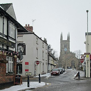
Lutterworth is a market town and civil parish in the Harborough district of Leicestershire, England. The town is located in southern Leicestershire, close to the borders with Warwickshire and Northamptonshire. It is located 6.4 miles north of Rugby, Warwickshire and 12 miles south of Leicester.

<span class="mw-page-title-main">Hinckley</span> Town in Leicestershire, England

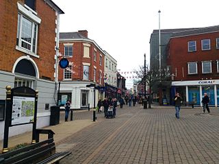
Hinckley is a market town in south-west Leicestershire, England. It is administered by Hinckley and Bosworth Borough Council. Hinckley is the third largest settlement in the administrative county of Leicestershire, after Leicester and Loughborough. Hinckley is about halfway between Leicester and Coventry and borders Nuneaton in Warwickshire. Watling Street forms part of the Hinckley/Nuneaton border.

<span class="mw-page-title-main">Evington</span> Human settlement in England

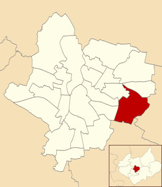
Evington is an area of Leicester, and electoral ward of the Leicester district, in the ceremonial county of Leicestershire, England. It used to be a small village centred on Main Street and the Anglican church of St Denys but was close enough to Leicester to become one of the outer suburbs in the 1930s. Today, the ward comprises the historical village of Evington, as well as the modern ex-council estates of Rowlatts Hill and Goodwood. The population of the ward at the 2011 census was 11,133.

<span class="mw-page-title-main">Oadby</span> Town in Leicestershire, England

Oadby is a town in the borough of Oadby and Wigston in Leicestershire, England. Oadby is a district centre 4 miles (6.4 km) south-east of Leicester on the A6 road. Leicester Racecourse is situated on the border between Oadby and Stoneygate. The University of Leicester Botanical Garden is in Oadby. Oadby had a population of 23,849 in 2011, and like its neighbour Wigston is made up of five wards. The Borough of Oadby and Wigston is twinned with Maromme in France, and Norderstedt in Germany.

<span class="mw-page-title-main">Leicester Forest East</span>

Leicester Forest East (LFE) is a large suburban village in Leicestershire, England, west of Leicester, straddling the M1 motorway. It is part of the Blaby district.

<span class="mw-page-title-main">Lymm</span> Human settlement in England

Lymm is a village and civil parish in the Borough of Warrington, Cheshire, England. It incorporates the hamlets of Booths Hill, Broomedge, Church Green, Deansgreen, Heatley, Heatley Heath, Little Heatley, Oughtrington, Reddish, Rushgreen and Statham. At the 2021 United Kingdom census it had a population of 12,700. The village is situated in the northern aspect of Cheshire and borders Greater Manchester to the East and lies 1 mile from the border of Salford to the north.

<span class="mw-page-title-main">Belgrave, Leicester</span> Suburb of Leicester, England

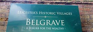
Belgrave is an area, suburb, electoral ward and administrative division of the city of Leicester, in the ceremonial county of Leicestershire, England. Belgrave is the location of and known for the National Space Centre, Space Park Leicester, the Golden Mile and Belgrave Hall.

<span class="mw-page-title-main">Anstey, Leicestershire</span> Human settlement in England

Anstey is a large village in Leicestershire, England, located north west of Leicester in the borough of Charnwood. Its population was 6,528 at the 2011 census. This figure is expected to increase due to the building of a new housing development off Groby Road. The village is separated from Leicester by the Rothley Brook, Castle Hill Park and the A46, and it borders the villages of Glenfield, Groby, Newtown Linford, Cropston and Thurcaston as well as the suburb of Beaumont Leys and Anstey Heights. To the north-west lies Bradgate Park.

<span class="mw-page-title-main">Narborough, Leicestershire</span> Human settlement in England

Narborough is a large village and civil parish in the Blaby district of Leicestershire, England, around six miles southwest of Leicester. The population of the civil parish at the 2011 census was 8,498.

<span class="mw-page-title-main">Birstall, Leicestershire</span> Human settlement in England

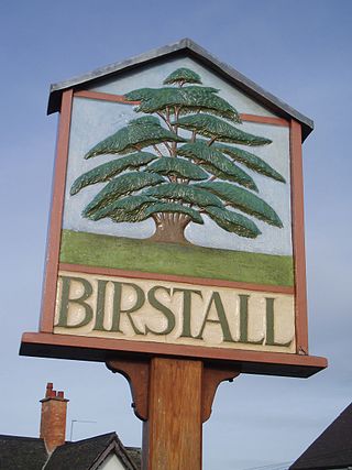
Birstall is a large village and civil parish within the Charnwood borough of Leicestershire, England. It is three miles north of Leicester city centre and is part of the wider Leicester Urban Area.

<span class="mw-page-title-main">Countesthorpe</span> Human settlement in England

Countesthorpe is a large village and civil parish in the Leicestershire district of Blaby, with a population of 6,393 (2001 census, falling slightly to 6,377 at the 2011 census. It lies to the south of Leicester, and is about 6 miles from the city centre, but only two miles south of the suburb of South Wigston. Nearby places are Blaby and South Wigston to the north, Kilby to the east, Peatling Magna and Willoughby Waterleys to the south, and Broughton Astley, Cosby and Whetstone to the west.

<span class="mw-page-title-main">Sileby</span> Human settlement in England

Sileby is a former industrial village and civil parish in the Soar Valley in the Charnwood borough of Leicestershire, England. It is located between Leicester and Loughborough. The village is close to Barrow upon Soar, Mountsorrel, Ratcliffe-on-the-Wreake, Seagrave and Cossington. The population of the civil parish at the 2011 census was 7,835, rising to 8,959 at the 2021 census.

<span class="mw-page-title-main">Clarendon Park, Leicester</span>

Clarendon Park is an area in the south of the city of Leicester. It is bordered by Welford Road to the west, London Road to the east, Victoria Park to the north and Avenue Road/Avenue Road Extension to the south. It is part of Castle Ward and the constituency of Leicester South. There are two major shopping streets; Queens Road and Clarendon Park Road. These two roads intersect near the centre of Clarendon Park, with Queens Road running north–south, and Clarendon Park Road running east–west.

<span class="mw-page-title-main">Ullesthorpe</span> Human settlement in England

Ullesthorpe is a small village and civil parish situated in the Harborough district in southern Leicestershire. Ullesthorpe is noted for its historic background with a mill, disused railway station and traces of a medieval settlement evident on the edge of the village.

<span class="mw-page-title-main">Higham on the Hill</span> Human settlement in England

Higham on the Hill is a village and civil parish in the Hinckley and Bosworth district of Leicestershire, England. The population at the 2011 census was 840.

<span class="mw-page-title-main">Enderby, Leicestershire</span> Human settlement in England

Enderby is a village and civil parish in Leicestershire, England, on the southwest outskirts of the city of Leicester. The parish includes the neighbourhood of St John's, which is east of the village separated from it by the M1 motorway. The 2011 Census recorded the parish's population as 6,314.

Eyres Monsell is an electoral ward and administrative division in Leicester, England.

<span class="mw-page-title-main">Humberstone and Hamilton</span> Electoral ward and administrative division of Leicester, England

Humberstone and Hamilton is an electoral ward and administrative division of the City of Leicester, England. It comprises the north-eastern Leicester suburbs of Humberstone, Humberstone Garden City, Hamilton and Netherhall.

References

  1. "Western Park, 2011". UK Census Data. Retrieved 18 May 2019.
  2. "The History of Western Park". Leicester City Council. Archived from the original on 18 June 2011. Retrieved 18 May 2019.
  3. "General Information". Friends of Western Park. Retrieved 18 May 2019.
  4. 1 2 "Western Park, Hinckley Road". Leicester City Council. Archived from the original on 22 February 2012. Retrieved 18 May 2019.
  5. "The history of Westfields Tennis Club". Westfields Tennis Club - Leicester. Retrieved 18 May 2019.
  6. Mair, Vibeka (8 May 2013). "Groundwork Leicester and Leicestershire closes down". Civil Society Media. Retrieved 18 May 2019.
  7. "About Us". Groundwork Leicester & Leicestershire. Archived from the original on 1 April 2015. Retrieved 18 May 2019.
  8. "EcoHouse". Groundwork Leicester and Leicestershire. Archived from the original on 4 December 2008. Retrieved 18 May 2019.
  9. "Welcome". Groundwork Leicester & Leicestershire. Archived from the original on 28 February 2008. Retrieved 18 May 2019.
  10. "Friends of Western Park". Leicester City Council. Archived from the original on 1 September 2012. Retrieved 18 May 2019.
  11. "Home". Friends of Western Park. Retrieved 18 May 2019.
  12. "Welcome: About Us". Dovelands Primary School. Retrieved 18 May 2019.
  13. "St Anne's Parish Church". A Church Near You. Retrieved 18 May 2019.
  14. "Home". Westfields Tennis Club - Leicester. Retrieved 18 May 2019.
  15. "Performance Inspection & Ofsted Report". Christ The King Catholic Voluntary Academy. Retrieved 18 May 2019.
  16. "Detailed Results for Western Park ward". Leicester City Council. 2007. Archived from the original on 9 May 2007. Retrieved 18 May 2019.

52°38′06″N1°10′34″W / 52.635°N 1.176°W / 52.635; -1.176