Beerwah, Queensland

Last updated

Beerwah
Sunshine Coast,  Queensland
Beerwah fruit and vegetable display, RNA Exhibition, Brisbane, August 1984.jpg
Beerwah fruit and vegetable display, RNA Exhibition, Brisbane, August 1984
Australia Queensland location map.svg
Red pog.svg
Beerwah
Coordinates 26°51′30″S152°57′32″E / 26.8583°S 152.9588°E / -26.8583; 152.9588 (Beerwah (town centre))
Population7,734 (2021 census) [1]
 • Density133.12/km2 (344.8/sq mi)
Postcode(s) 4519
Area58.1 km2 (22.4 sq mi)
Time zone AEST (UTC+10:00)
Location
LGA(s) Sunshine Coast Region
County Canning
Parish Bribie
State electorate(s)
Federal division(s) Fisher
Localities around Beerwah:
Peachester
Mount Mellum
Landsborough Bells Creek
Peachester Beerwah Coochin Creek
Glass House Mountains Glass House Mountains Coochin Creek

Beerwah ( /ˈbɪərwɑː,-wɔː/ ) is a rural town and locality in the hinterland of the Sunshine Coast Region, Queensland, Australia. [2] [3] At the 2021 census, the locality of Beerwah had a population of 7,734 people. [1]

Contents

Australia Zoo, located in Beerwah, is a major tourist attraction and is visited daily by large numbers of local, national and international tourists. Beerwah has transport links to Brisbane and northbound destinations via the Beerwah railway station on the Nambour and Gympie North railway line. Roads in the area include a bypass in the south of the town, Kilcoy-Beerwah Road and Steve Irwin Way.

Geography

Beerwah is situated north of Glass House Mountains, approximately 80 kilometres (50 mi) north of Brisbane, and just south of Landsborough. The main road through Beerwah is called Steve Irwin Way. [4] It was formerly known as the Glasshouse Mountain Tourist Route and is accessed by the Bruce Highway, which bypassed the town in 1985. Kilcoy–Beerwah Road enters from the west. [5]

History

The name Beerwah comes from the Kabi language (Turrbal dialect) word birrawaman, with birra meaning sky and wandum meaning climbing up. [2] [3]

Beerwah Post Office opened by August 1907 (a receiving office had been open from 1891). [6]

The first building and pupils of the Coochin Creek Provisional School (later Beerwah State School), 1888 The first building and pupils of the Coochin Creek Provisional School (later Beerwah State School), 1888.jpg
The first building and pupils of the Coochin Creek Provisional School (later Beerwah State School), 1888

The Coochin Creek Provisional School opened on 27 November 1888 with an initial enrolment of 19 students under teacher William Verrants. By the end of 1888, there were 43 students enrolled. It was on the main Peachester road, 1.5 miles (2.4 km) from the Beerwah railway station. On 1 January 1909, it became Coochin Creek State School. In about November 1928, it was renamed Beerwah State School. The school celebrated its golden jubilee in 1938. [7] On 10 July 1952, another Coochin Creek State School opened, but it closed on 11 March 1962. [8] [9] [10]

On Saturday 26 September 1914, the local Anglican residents held a meeting to consider erecting a church in Beerwah. Mr Mawhinney donated a piece of land by the railway station. [11] On Saturday 7 November 1914 Archdeacon Henry Le Fanu officially capped the first stump of the new church building. All the materials for the church and the labour were all donated so the church would be free of debt. [12] On Saturday 6 March 1916, Archdeacon Le Fanu returned to officially open and dedicate St James' Anglican Church. [13] In the 1990s, diminishing numbers in the congregations led to a decision to close a number of churches in the area. St James' was closed and sold for removal. [14]

On 4 July 1991, the Mary MacKillop Catholic Centre was blessed and opened by Archbishop Francis Rush. [15]

Beerwah State High School opened on 1 January 1992. [16] [10]

The Beerwah Library opened in 2000. [17]

Glasshouse Country Christian College was established on 31 January 2000 by the Glasshouse Country Baptist Church with an initial 16 students. [10] [18]

Glasshouse Country Uniting Church opened its church at Beerwah on 16 December 2000, The architects were Thomson Adsett Architects. It was a result of the merger of the Glasshouse Uniting Church, Beerwah Uniting Church, Landsborough Uniting Church and Mooloolah Uniting Church. [19]

In the 2016 census, the locality of Beerwah had a population of 6,769 people, 52% female and 48% male. [20] The median age was 39 years, compared to the national median age of 38. Aboriginal and Torres Strait Islander people made up 2.8% of the population. 77.2% of people were born in Australia. The next most common countries of birth were England 5.1% and New Zealand 4.8%. 90.8% of people only spoke English at home. The most common responses for religion in Beerwah were No Religion 32.8%, Anglican 17.2% and Catholic 14.4%. [20]

Heritage listings

Beerwah has a number of heritage-listed sites, including:

Transport

Beerwah is a growing hinterland town. [26] Transport links to Brisbane and northbound destinations at Beerwah railway station on the Nambour and Gympie North railway line. Beerwah has high public transport usage with 0.6% of residents using public transportation for their work commute, placing it in the top 20% on the Sunshine Coast. [27]

A small bypass was constructed south of the town, including an overpass of the railway, a large roundabout at Roberts Road, and traffic signals at Kilcoy-Beerwah Road and Steve Irwin Way. This work opened to traffic in October 2009. As part of that project, however, the original level crossing was closed and demolished, causing concern among local residents who claimed it sliced the town in two. [28] In 2010, many residents began to complain about the lack of signage to the town centre. The town entrance now features two distinctive large directional signs, one at the Steve Irwin Way entrance, and one at the roundabout after travelling over the railway bridge.

Education

Beerwah State School is a government primary (Early Childhood-6) school for boys and girls at 2788 Old Gympie Road ( 26°51′19″S152°56′24″E / 26.8554°S 152.9399°E / -26.8554; 152.9399 (Beerwah State School) ). [29] [30] [31] In 2018, the school had an enrolment of 367 students with 40 teachers (32 full-time equivalent) and 21 non-teaching staff (15 full-time equivalent). [32] It includes a special education program. [29] [33]

Glasshouse Christian College is a private primary and secondary (Prep-12) school for boys and girls at 58 Roberts Road ( 26°51′42″S152°57′06″E / 26.8616°S 152.9518°E / -26.8616; 152.9518 (Glasshouse Christian College) ). [29] [34] In 2018, the school had an enrolment of 1074 students with 75 teachers (70 full-time equivalent) and 67 non-teaching staff (48 full-time equivalent). [32] [33]

Beerwah State High School is a government secondary (7-12) school for boys and girls at 35 Roberts Road ( 26°51′46″S152°57′14″E / 26.8627°S 152.9540°E / -26.8627; 152.9540 (Beerwah State High School) ). [29] [35] [36] In 2018, the school had an enrolment of 895 students with 86 teachers (79 full-time equivalent) and 44 non-teaching staff (30 full-time equivalent). [32] It includes a special education program. [29] [33]

Amenities

The Sunshine Coast Regional Council operates a public library at 25 Peachester Road. [37]

There are a range of national supermarkets, specialty shops, and a retirement village.[ citation needed ]

The Beerwah branch of the Queensland Country Women's Association meets at 39 Simpson Street. [38]

Anglican church services are held at the Mary MacKillop Catholic Centre at 160 Peachester Road ( 26°51′28″S152°56′34″E / 26.8579°S 152.9427°E / -26.8579; 152.9427 (Mary MacKillop Catholic Centre) ). [14] [39] [40]

Glasshouse Country Uniting Church (also known as Beewah Uniting Church) is at 29 Twin Peaks Drive ( 26°52′18″S152°57′36″E / 26.8718°S 152.9599°E / -26.8718; 152.9599 (Beerwah Uniting Church) ). [41] [42] [43] [19]

There are a number of parks in the locality, including:

Attractions

The Big Mower BigMower Beerwah.jpg
The Big Mower

Australia Zoo is located in Beerwah. The zoo was founded by Bob Irwin and later made famous by his son, Steve Irwin. It is a major tourist attraction and is visited daily by large numbers of local, national and international tourists.

Another attraction, the Glass House mountain range, is located nearby. The largest mountain in the range, at 555m, is Mount Beerwah. Access to the Mount Beerwah summit route has been closed since 2008 due to the erosion and destabilization of some walking tracks, leading to a high risk of rock fall. [45]

The Big Mower, one of Australia's big things, is located in Beerwah.

Beerwah Railway Station, Queensland, June 2012 Beerwah Railway Station, Queensland, June 2012.JPG
Beerwah Railway Station, Queensland, June 2012

Notable residents

See also

Related Research Articles

<span class="mw-page-title-main">Glass House Mountains National Park</span> Protected area in Queensland, Australia

Glass House Mountains National Park is a heritage-listed national park at Glass House Mountains, Sunshine Coast Region, Queensland, Australia. It is also known as Beerburrum Forest Reserve 1. It is 70 km (43 mi) north of Brisbane and consists of a flat plain punctuated by rhyolite and trachyte volcanic plugs, the cores of extinct volcanoes that formed 26 million to 27 million years ago. The mountains would once have had pyroclastic exteriors, but these have eroded away.

<span class="mw-page-title-main">Boonah, Queensland</span> Town in Queensland, Australia

Boonah is a rural town and locality in the Scenic Rim Region, Queensland, Australia. In the 2016 census, the locality of Boonah had a population of 2,484 people.

<span class="mw-page-title-main">Palmwoods, Queensland</span> Town in Queensland, Australia

Palmwoods is a rural town and locality in the Sunshine Coast Region, Queensland, Australia. In the 2021 census, the locality of Palmwoods had a population of 6,357 people.

<span class="mw-page-title-main">Glass House Mountains, Queensland</span> Town in Queensland, Australia

Glass House Mountains is a rural hinterland town and locality in the Sunshine Coast Region, Queensland, Australia. In the 2016 census, the locality of Glass House Mountains had a population of 5,065 people.

<span class="mw-page-title-main">Maleny, Queensland</span> Town in Queensland, Australia

Maleny is a rural town and locality in the Sunshine Coast Region, Queensland, Australia. Maleny was a timber town until the early 1920s and then was a centre of dairy production and fruit growing. In the 2021 census, the locality of Maleny had a population of 3,959 people.

<span class="mw-page-title-main">Mooloolah Valley, Queensland</span> Suburb of Sunshine Coast Region, Queensland, Australia

Mooloolah Valley is a rural locality in the Sunshine Coast Region, Queensland, Australia. In the 2021 census, Mooloolah Valley had a population of 3,629 people.

<span class="mw-page-title-main">Landsborough, Queensland</span> Town in Queensland, Australia

Landsborough is a town and a locality in the Sunshine Coast Region, Queensland, Australia. At the 2021 census, Landsborough had a population of 4,446 people.

<span class="mw-page-title-main">Beerburrum, Queensland</span> Town in Queensland, Australia

Beerburrum is a small town and coastal locality in the Sunshine Coast Region, Queensland, Australia. In the 2016 census, Beerburrum had a population of 763 people.

Montville is a rural town and locality in the Sunshine Coast Region, Queensland, Australia. In the 2016 census, the locality of Montville had a population of 970 people.

<span class="mw-page-title-main">Diddillibah, Queensland</span> Suburb of Sunshine Coast Region, Queensland, Australia

Diddillibah is a semi-rural locality in the Sunshine Coast Region, Queensland, Australia. In the 2021 census, Diddillibah had a population of 1,703 people.

<span class="mw-page-title-main">Ninderry, Queensland</span> Town in Queensland, Australia

Ninderry is a rural town and locality in the Sunshine Coast Region, Queensland, Australia. In the 2016 census, the locality of Ninderry had a population of 1,087 people.

<span class="mw-page-title-main">Glass House Mountains</span> Mountain range in Queensland, Australia

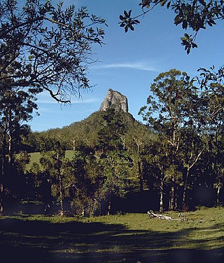
The Glass House Mountains are a cluster of thirteen hills that rise abruptly from the coastal plain on the Sunshine Coast, Queensland, Australia. The highest hill is Mount Beerwah at 556 metres above sea level, but the most identifiable of all the hills is Mount Tibrogargan which from certain angles bears a resemblance to a gorilla facing east towards the ocean. The Glass House Mountains are located near Beerburrum State Forest and Steve Irwin Way. From Brisbane, the mountains can be reached by following the Bruce Highway north and taking the Glass House Mountains tourist drive turn-off onto Steve Irwin Way. The trip is about one hour from Brisbane. The Volcanic peaks of the Glass House Mountains rise dramatically from the surrounding Sunshine Coast landscape. They were formed by intrusive plugs, remnants of volcanic activity that occurred 26–27 million years ago. Molten rock filled small vents or intruded as bodies beneath the surface and solidified into land rocks. Millions of years of erosion have removed the surrounding exteriors of volcanic cores and softer sandstone rock.

<span class="mw-page-title-main">Peachester, Queensland</span> Town in Queensland, Australia

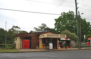
Peachester is a rural town and locality in the Sunshine Coast Region, Queensland, Australia. In the 2016 census the locality of Peachester had a population of 1,357 people.

<span class="mw-page-title-main">Coochin Creek</span> Suburb of Sunshine Coast, Queensland, Australia

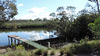
Coochin Creek is a coastal locality in the south of the Sunshine Coast Region, Queensland, Australia. The locality is named for the creek which flows through it.

<span class="mw-page-title-main">Wild Horse Mountain</span>

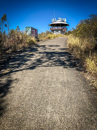
Wild Horse Mountain is the smallest of the Glass House Mountains on the Sunshine Coast, Queensland, Australia. It is with the locality of Coochin Creek in the Sunshine Coast Region. The peak rises to 123 metres (404 ft). It is located east of the Bruce Highway unlike all other peaks within the Glass House Mountains and thus provides great views of the other mountains.

<span class="mw-page-title-main">Crohamhurst, Queensland</span> Suburb of Sunshine Coast Region, Queensland, Australia

Crohamhurst is a rural locality in the Sunshine Coast Region, Queensland, Australia. In the 2021 census, Crohamhurst had a population of 219 people.

<span class="mw-page-title-main">Booroobin</span> Suburb of City of Moreton Bay, Queensland, Australia

Booroobin is a rural locality split between the City of Moreton Bay and the Sunshine Coast Region in Queensland, Australia. In the 2021 census, Booroobin had a population of 258 people.

Stanmore is a rural locality in the City of Moreton Bay, Queensland, Australia. In the 2021 census, Stanmore had a population of 454 people.

Mount Mellum is a rural locality in the Sunshine Coast Region, Queensland, Australia. In the 2021 census, Mount Mellum had a population of 457 people.

Kilcoy–Beerwah Road is a continuous 30.4-kilometre (18.9 mi) road route in the Moreton Bay and Sunshine Coast local government areas of Queensland, Australia. It is designated as part of State Route 6. It is a state-controlled regional road. It is part of a route that carries tourist traffic from the New England Highway to the Bruce Highway.

References

  1. 1 2 Australian Bureau of Statistics (28 June 2022). "Beerwah (SAL)". 2021 Census QuickStats. Retrieved 11 July 2022. OOjs UI icon edit-ltr-progressive.svg
  2. 1 2 "Beerwah – town in Sunshine Coast Region (entry 2095)". Queensland Place Names. Queensland Government . Retrieved 29 December 2020.
  3. 1 2 "Beerwah – locality in Sunshine Coast Region (entry 48521)". Queensland Place Names. Queensland Government . Retrieved 29 December 2020.
  4. "Irwin our 'greatest cultural ambassador': Beattie". Brisbane Times . 4 September 2007. Archived from the original on 6 October 2012. Retrieved 20 November 2010.
  5. Google (8 November 2022). "Beerwah" (Map). Google Maps . Google. Retrieved 8 November 2022.
  6. Phoenix Auctions History. "Post Office List". Phoenix Auctions. Archived from the original on 29 May 2022. Retrieved 15 February 2021.
  7. "Happy school days recalled. Beerwah School celebrates 50th anniversary. First teacher returns to call roll". Nambour Chronicle And North Coast Advertiser . Vol. XXXII, no. 1771. Queensland, Australia. 13 May 1938. p. 1. Retrieved 27 January 2023 via National Library of Australia.
  8. "Agency ID 4832, Beerwah State School". Queensland State Archives . Retrieved 15 April 2014.
  9. "Agency ID 4832, Coochin Creek State School". Queensland State Archives . Retrieved 15 April 2014.
  10. 1 2 3 Queensland Family History Society (2010), Queensland schools past and present (Version 1.01 ed.), Queensland Family History Society, ISBN   978-1-921171-26-0
  11. "BEERWAH". Chronicle And North Coast Advertiser . Vol. XI, no. 581. Queensland, Australia. 2 October 1914. p. 2. Archived from the original on 25 September 2020. Retrieved 25 September 2020 via National Library of Australia.
  12. "ANGLICAN ACTIVITY AT BEERWAH". The Telegraph . No. 13, 100. Queensland, Australia. 14 November 1914. p. 9. Archived from the original on 25 September 2020. Retrieved 25 September 2020 via National Library of Australia.
  13. "RELIGIOUS". The Brisbane Courier . No. 17, 834. Queensland, Australia. 13 March 1915. p. 16. Archived from the original on 25 September 2020. Retrieved 25 September 2020 via National Library of Australia.
  14. 1 2 "Parish profile" (PDF). The Anglican Parish of Caloundra-Glasshouse Country. p. 3. Archived (PDF) from the original on 24 September 2020. Retrieved 25 September 2020.
  15. "Beerwah Catholic Church". Churches Australia. Archived from the original on 25 September 2020. Retrieved 25 September 2020.
  16. "Agency ID 5163, Beerwah State High School". Queensland State Archives . Retrieved 15 April 2014.
  17. "Public Libraries Statistical Bulletin 2016-17" (PDF). Public Libraries Connect. State Library of Queensland. November 2017. p. 15. Archived (PDF) from the original on 30 January 2018. Retrieved 30 January 2018.
  18. "Glasshouse Christian College: A Sunshine Coast Independent School". Glasshouse Christian College. Archived from the original on 10 March 2021. Retrieved 2 April 2021.
  19. 1 2 "Glasshouse Country Uniting Church". Churches Australia. Archived from the original on 28 August 2021. Retrieved 28 August 2021.
  20. 1 2 Australian Bureau of Statistics (27 June 2017). "Beerwah (SSC)". 2016 Census QuickStats. Retrieved 20 October 2018. OOjs UI icon edit-ltr-progressive.svg
  21. "Beerwah Hotel" (PDF). Sunshine Coast Region Heritage Register. Sunshine Coast Regional Council . Retrieved 20 April 2019.
  22. "Site of Coochin Homestead" (PDF). Sunshine Coast Region Heritage Register. Sunshine Coast Regional Council . Retrieved 20 April 2019.
  23. "Beerburrum Scientific Area No 1" (PDF). Sunshine Coast Region Heritage Register. Sunshine Coast Regional Council . Retrieved 20 April 2019.
  24. "Beerwah Forest Station and Arboretum (former)" (PDF). Sunshine Coast Region Heritage Register. Sunshine Coast Regional Council . Retrieved 20 April 2019.
  25. "Beerwah Railway Station" (PDF). Sunshine Coast Region Heritage Register. Sunshine Coast Regional Council . Retrieved 20 April 2019.
  26. Owen Jacques (11 November 2010). "Hinterland to get 300 new homes". Sunshine Coast Daily . APN News & Media Ltd. Archived from the original on 13 November 2010. Retrieved 20 November 2010.
  27. "People & Lifestyle Beerwah Qld 4519". www.microburbs.com.au. Retrieved 17 July 2023.
  28. "Councillor calls on Government to keep Beerwah crossing". viewnews.com.au. View News & Media. 7 October 2009. Archived from the original on 6 October 2011. Retrieved 23 June 2011.
  29. 1 2 3 4 5 "State and non-state school details". Queensland Government. 9 July 2018. Archived from the original on 21 November 2018. Retrieved 21 November 2018.
  30. "Beerwah State School". Beerwah State School. 16 September 2022. Retrieved 27 January 2023.
  31. "Beerwah State School". Archived from the original on 3 March 2021. Retrieved 2 April 2021.
  32. 1 2 3 "ACARA School Profile 2018". Australian Curriculum, Assessment and Reporting Authority. Archived from the original on 27 August 2020. Retrieved 28 January 2020.
  33. 1 2 3 "Beerwah Schools". Archived from the original on 20 February 2012. Retrieved 19 April 2018.
  34. "Glasshouse Christian College". Archived from the original on 6 March 2016. Retrieved 21 November 2018.
  35. "Beerwah State High School". Beerwah State High School. 3 August 2021. Retrieved 27 January 2023.
  36. "Beerwah State High School". Archived from the original on 3 March 2021. Retrieved 2 April 2021.
  37. "Beerwah Library". Sunshine Coast Regional Council . Archived from the original on 30 January 2018. Retrieved 30 January 2018.
  38. "Branch Locations". Queensland Country Women's Association. Archived from the original on 26 December 2018. Retrieved 26 December 2018.
  39. "Beerwah Anglican Church". Churches Australia. Archived from the original on 25 September 2020. Retrieved 25 September 2020.
  40. "Churches & Mass Centres". Caloundra Catholic Parish. Archived from the original on 25 September 2020. Retrieved 25 September 2020.
  41. "Glasshouse Country Uniting Church". Archived from the original on 22 April 2013. Retrieved 28 August 2021.
  42. "Beerwah Church Location – Glasshouse Country Uniting Church". Archived from the original on 28 August 2021. Retrieved 28 August 2021.
  43. "Find a church". Uniting Church in Australia, Queensland Synod. Archived from the original on 24 October 2020. Retrieved 6 May 2021.
  44. 1 2 3 4 5 6 7 8 9 10 11 12 13 14 15 16 17 18 19 20 21 22 23 24 25 26 27 28 29 30 31 32 33 34 35 36 37 38 39 40 41 42 43 44 45 46 47 48 49 50 51 52 53 "Land for public recreation - Queensland". Queensland Open Data. Queensland Government. 20 November 2020. Archived from the original on 22 November 2020. Retrieved 22 November 2020.
  45. "Mount Beerwah summit route—temporary closure". Queensland Government. Archived from the original on 4 September 2015. Retrieved 16 July 2015.