
The Black Rock Desert is a semi-arid region of lava beds and playa, or alkali flats, situated in the Black Rock Desert–High Rock Canyon Emigrant Trails National Conservation Area, a silt playa 100 miles (160 km) north of Reno, Nevada that encompasses more than 300,000 acres (120,000 ha) of land and contains more than 120 miles (200 km) of historic trails. It is in the northern Nevada section of the Great Basin with a lakebed that is a dry remnant of Pleistocene Lake Lahontan.

The Santa Monica Mountains is a coastal mountain range in Southern California, next to the Pacific Ocean. It is part of the Transverse Ranges. The Santa Monica Mountains National Recreation Area encompasses this mountain range. Because of its proximity to densely populated regions, it is one of the most visited natural areas in California.

The Owens River is a river in eastern California in the United States, approximately 183 miles (295 km) long. It drains into and through the Owens Valley, an arid basin between the eastern slope of the Sierra Nevada and the western faces of the Inyo and White Mountains. The river terminates at the endorheic Owens Lake south of Lone Pine, at the bottom of a 2,600 sq mi (6,700 km2) watershed.

The Inyo Mountains are a short mountain range east of the Sierra Nevada in eastern California in the United States. The range separates the Owens Valley to the west from Saline Valley to the east, extending for approximately 70 miles (110 km) south-southeast from the southern end of the White Mountains, from which they are separated by Westgard Pass, to the east of Owens Lake.
Red Slate Mountain is a summit in the Sierra Nevada. It lies along the Sierra Crest that divides Fresno County from Mono County, California.

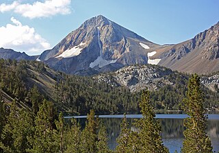
Mount Humphreys is a mountain peak in the Sierra Nevada on the Fresno-Inyo county line in the U.S. state of California. It is the 13th highest peak in California, and the highest peak in the Bishop area. The mountain was named by the California Geological Survey of 1873 for Andrew A. Humphreys, the chief engineer of the United States Army at the time.

Castle Peak is a mountain in California's Sierra Nevada near I-80, Donner Pass, and the Nevada border. It is in the Tahoe National Forest not far off the Pacific Crest Trail, and adjacent to Castle Pass. It was originally named Mount Stanford by the Whitney Survey of 1860–74.

The Simi Hills are a low rocky mountain range of the Transverse Ranges in eastern Ventura County and western Los Angeles County, of southern California, United States.

The Dead Mountains are a mountain range in the southeastern Mojave Desert, in San Bernardino County, California. The range borders the tri-state intersection of Nevada, Arizona and California, and the Mohave Valley, with the Fort Mojave Indian Reservation bordering the range foothills on the east and northeast, in the three states.

Ironwood Forest National Monument is located in the Sonoran Desert of Arizona. Created by Bill Clinton by Presidential Proclamation 7320 on June 9, 2000, the monument is managed by the Bureau of Land Management, an agency within the United States Department of the Interior. The monument covers 129,055 acres (52,227 ha), of which 59,573 acres (24,108 ha) are non-federal and include private land holdings and Arizona State School Trust lands.

Mount Tallac is a mountain peak southwest of Lake Tahoe, in El Dorado County, California. The peak lies within the Desolation Wilderness in the Eldorado National Forest. It is quite visible from State Routes 89 and 28, and U.S. Route 50. A "cross of snow" is clearly visible on the mountain's face during the winter, spring, and early summer months.

Silverwood Lake is a large reservoir in San Bernardino County, California, United States, located on the West Fork Mojave River, a tributary of the Mojave River in the San Bernardino Mountains. It was created in 1971 as part of the State Water Project by the construction of the Cedar Springs Dam as a forebay on the 444 mi (715 km) long California Aqueduct, and has a capacity of 73,000 acre⋅ft (90,000,000 m3).
Black Mountain is a mountain located in Catron County, New Mexico, on the northern boundary of the Gila Wilderness and in the Gila National Forest.

Mount Eddy is the highest peak of the Trinity Mountains, a mountain range of the Klamath Mountains System, located in Siskiyou County, and Trinity County in northern California.

Freel Peak is a mountain located in the Carson Range, a spur of the Sierra Nevada, near Lake Tahoe in California.

Olancha Peak is a mountain in the Sierra Nevada of California. It rises to an elevation of 12,132 feet (3,698 m) on the Tulare-Inyo county line in the South Sierra Wilderness. It takes its name from the nearby town of Olancha.

The Mountain states form one of the nine geographic divisions of the United States that are officially recognized by the United States Census Bureau. It is a subregion of the Western United States.

Cathedral Peak is a high mountain summit in the Elk Mountains range of the Rocky Mountains of North America. The 13,950-foot (4,252 m) thirteener is located in the Maroon Bells-Snowmass Wilderness of White River National Forest, 11.1 miles (17.9 km) south by west of the City of Aspen in Piktin County, Colorado, United States.

