
Easton is a town in Bristol County, Massachusetts, United States. The population was 25,058 at the 2020 census. It is part of the Greater Boston area.

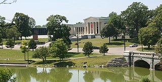
The Back Bay Fens, often called The Fens, is a parkland and urban wild in Boston, Massachusetts, United States. It was established in 1879. Designed by Frederick Law Olmsted to serve as a link in the Emerald Necklace park system, the Fens gives its name to the Fenway-Kenmore neighborhood.

The Olmsted Brothers company was a landscape architectural firm in the United States, established in 1898 by brothers John Charles Olmsted (1852–1920) and Frederick Law Olmsted Jr. (1870–1957), sons of the landscape architect Frederick Law Olmsted.

Frederick Law Olmsted National Historic Site is a United States National Historic Site located in Brookline, Massachusetts, a suburb of Boston. Frederick Law Olmsted (1822–1903) is recognized as the founder of American landscape architecture and the nation's foremost parkmaker of the 19th century. In 1883, Olmsted moved his home to suburban Boston and established "Fairsted", the world's first full-scale professional office for the practice of landscape design. Over the course of the next century, his sons and successors expanded and perpetuated Olmsted's design ideals, philosophy, and influence.

Bushnell Park in Hartford, Connecticut is the oldest publicly funded park in the United States. It was conceived by the Reverend Horace Bushnell in the mid-1850s at a time when the need for open public spaces was just starting to be recognized. Today the park comprises 50 acres (20 ha) of green space, and is visited by over one million people each year. Paths through the park contribute to the East Coast Greenway.

Bela Lyon Pratt was an American sculptor from Connecticut.
Delaware Park–Front Park System is a historic park system and national historic district in the northern and western sections of Buffalo in Erie County, New York. The park system was designed by Frederick Law Olmsted and Calvert Vaux and developed between 1868 and 1876.

Sheridan Circle is a traffic circle and park in the Sheridan-Kalorama neighborhood of Washington, D.C. The traffic circle, one of two in the neighborhood, is the intersection of 23rd Street NW, Massachusetts Avenue NW, and R Street NW. The buildings along this stretch of Massachusetts Avenue NW are part of Embassy Row, which runs from Scott Circle to Observatory Circle. Sheridan Circle is a contributing property to the Massachusetts Avenue Historic District and the Sheridan-Kalorama Historic District, both listed on the National Register of Historic Places (NRHP). In addition, the equestrian statue of General Philip Sheridan is 1 of 18 Civil War Monuments in Washington, D.C., that were collectively listed on the NRHP.
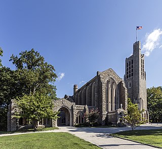
Washington Memorial Chapel in Valley Forge National Historical Park is a national memorial dedicated to General George Washington and an active Episcopal parish in Valley Forge, Pennsylvania. The church was inspired by a sermon preached by Anglican minister Reverend Dr. W. Herbert Burk, founder and first rector of the parish. The building was designed by architect Milton B. Medary. It was listed on the National Register of Historic Places on May 1, 2017, and is undergoing an active restoration campaign.
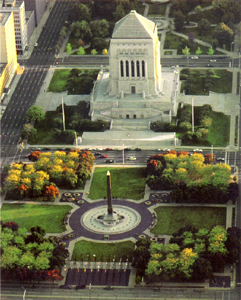
The Indiana World War Memorial Plaza is an urban feature and war memorial located in downtown Indianapolis, Indiana, United States, originally built to honor the veterans of World War I. It was conceived in 1919 as a location for the national headquarters of the American Legion and a memorial to the state's and nation's veterans.
The Common Burying Ground at Sandy Bank is a historic cemetery in Malden, Massachusetts, US. It occupies a roughly rectangular parcel of land 3.3 acres (1.3 ha) in size, bounded by Medford Street on the north, Green Street on the east, Converse Avenue on the south and the Saugus Branch Railroad on the west. It is the oldest cemetery in the city, established in 1649. Its earliest probable burial dates to that same year, although the oldest gravestone, that of Alice Brackenbury, bears the date 1670. The Malden Public Library, in its local history collection, has a multi-volume set of binders that contain alphabetically ordered photographs of every grave in the cemetery with the epitaphs on each gravestone transcribed below its picture.

Pulaski Park is a city park along the Connecticut River in Holyoke, Massachusetts. Originally called Prospect Park when it was laid out in 1884, it was given its present name in 1939 in honor of American Revolutionary War hero Casimir Pulaski, for whom there is a memorial in the park's center. The original 5.1-acre (2.1 ha) park was designed by the Olmsted Brothers landscape design firm.
The H. H. Richardson Historic District of North Easton is a National Historic Landmark District in the village of North Easton in Easton, Massachusetts. It consists of five buildings designed by noted 19th-century architect Henry Hobson Richardson, and The Rockery, a war memorial designed by Frederick Law Olmsted. It was declared a National Historic Landmark in 1987.

The Brookline Town Green Historic District encompasses the historic colonial heart of the town of Brookline, Massachusetts. Centered on a stretch of Walnut Street between Warren and Chestnut Streets, this area is where the town's first colonial meeting house and cemetery were laid out, and was its center of civic life until the early 19th century. The district was listed on the National Register of Historic Places in 1980.

Martin Luther King Jr. Park, originally The Parade and after 1896, Humboldt Park, is a historic park located in Buffalo in Erie County, New York. The park is located in east Buffalo and bisected by Fillmore Avenue.
The Architecture of Buffalo, New York, particularly the buildings constructed between the American Civil War and the Great Depression, is said to have created a new, distinctly American form of architecture and to have influenced design throughout the world.
Seaside Park, located in Bridgeport, Connecticut, is a 2.5-mile (4.0 km) long crescent-shaped park bordering Bridgeport Harbor, Long Island Sound, and Black Rock Harbor. The park lies within Bridgeport's South End neighborhood.

American Revolution Statuary is a group of fourteen statues in Washington, D.C., which honor men whose actions assisted the Thirteen Colonies in their fight against the Kingdom of Great Britain in the American Revolutionary War. They are spread throughout the city, except for the four statues in Lafayette Square, across from the White House, that honor some of the foreign heroes from the war. Some of the statues are located in prominent places, while others are in small parks or stand alone in front of buildings. All of the statues are owned and maintained by the National Park Service, an agency of the United States Department of the Interior. The statuary was collectively listed on the National Register of Historic Places (NRHP) in 1978 and the District of Columbia Inventory of Historic Sites the following year. In addition, most are also contributing properties to historic districts listed on the NRHP.

Captain Nathan Hale is a bronze statue of Nathan Hale (1755-1776), a schoolteacher from Connecticut, who enlisted in the Continental Army during the American Revolutionary War. He was stationed in Boston, but was later transferred to the New York City area. While in New York, Hale acted as a spy against the Kingdom of Great Britain's army. He posed as a teacher and was able to cross enemy lines to obtain military information. He left the area and before he could return home, his cousin, a Loyalist, informed the British about what Hale had done. He was captured and sentenced to death, with the hanging occurring the following day. While Hale was on the gallows, he gave a speech which ended with his famous quote: "I only regret that I have but one life to lose for my country."


