Bellefont, Kansas

Last updated

Bellefont, Kansas
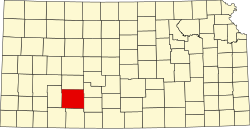
Map of Ford Co, Ks, USA.png
USA Kansas location map.svg
Red pog.svg
Bellefont
Usa edcp location map.svg
Red pog.svg
Bellefont
Coordinates: 37°52′21″N99°39′28″W / 37.87250°N 99.65778°W / 37.87250; -99.65778 [1]
Country United States
State Kansas
County Ford
Founded1870s
Elevation
[1]
2,356 ft (718 m)
Time zone UTC-6 (CST)
  Summer (DST) UTC-5 (CDT)
Area code 620
FIPS code 20-05450
GNIS ID 473745 [1]

Bellefont is an unincorporated community in Ford County, Kansas, United States. [1] It is located along Highway 50.

Contents

History

A post office in Bellefont opened in 1878, closed in 1896, reopened in 1904, and closed permanently in 1957. [2]

Related Research Articles

<span class="mw-page-title-main">Ford County, Kansas</span> County in Kansas, United States

Ford County is a county located in the U.S. state of Kansas. Its county seat and most populous city is Dodge City. As of the 2020 census, its population was 34,287. The county was named in honor of James Ford, a brevet brigadier general during the American Civil War.

<span class="mw-page-title-main">Dodge City, Kansas</span> City in Ford County, Kansas

Dodge City is the county seat of Ford County, Kansas, United States, named after nearby Fort Dodge. As of the 2020 census, the population of the city was 27,788. The city is known in American culture for its history as a wild frontier town of the Old West.

<span class="mw-page-title-main">Ford, Kansas</span> City in Ford County, Kansas

Ford is a city in Ford County, Kansas, United States. As of the 2020 census, the population of the city was 203.

<span class="mw-page-title-main">Bloom, Kansas</span> Unincorporated community in Ford County, Kansas

Bloom is an unincorporated community in Ford County, Kansas, United States. Its post office closed in 1992. At a 2018 estimate, the community had a population of 94. It is located along U.S. Route 54 highway.

<span class="mw-page-title-main">Goshen Coach</span>

Goshen Coach was an American cutaway bus builder located in Salina, Kansas.

USS Ford County (LST-772) was an LST-542-class tank landing ship built for the United States Navy during World War II. Named after counties in Illinois and Kansas, she was the only U.S. Naval vessel to bear the name.

<span class="mw-page-title-main">Walker, Kansas</span> Unincorporated community in Ellis County, Kansas

Walker is an unincorporated community in Herzog Township, Ellis County, Kansas, United States. It is located between Hays and Russell, along old Hwy 40 on the north side of I-70. Walker has a post office with ZIP code 67674.

<span class="mw-page-title-main">National Register of Historic Places listings in Ford County, Kansas</span>

This is a list of the National Register of Historic Places listings in Ford County, Kansas.

<span class="mw-page-title-main">Windhorst, Kansas</span> Unincorporated community in Ford County, Kansas

Windhorst is an unincorporated community in Ford County, Kansas, United States. It is located along 131 Spur Rd between Iron Rd and Jewell Rd in a rural area between the communities of Bellefont and Bucklin, approximately 6 miles south of Bellefont or 15 miles north of Bucklin.

<span class="mw-page-title-main">Fort Dodge, Kansas</span> Unincorporated community in Ford County, Kansas

Fort Dodge is an unincorporated community in Grandview Township, Ford County, Kansas, United States. As of the 2020 census, the population of the community and nearby areas was 97. It is located on U.S. Route 400 5 miles (8 km) southeast of Dodge City. Fort Dodge has a post office with ZIP code 67843.

<span class="mw-page-title-main">Wright, Kansas</span> Unincorporated community in Ford County, Kansas

Wright is an unincorporated community in Ford County, Kansas, United States. As of the 2020 census, the population of the community and nearby areas was 145. It is located along Highway 50.

<span class="mw-page-title-main">Fort Dodge (United States Army Post)</span> American military base (1865–1882)

The site of Fort Dodge in the U.S. state of Kansas was originally an old campground for wagons traveling along the Santa Fe Trail, just west of the western junction of the Wet and Dry Routes and near the middle or Cimarron Cutoff. On March 23, 1865, Major General Grenville M. Dodge, who commanded the 11th and 16th Kansas Cavalry Regiments, wrote to Colonel James Hobart Ford to propose establishing a new military post west of Fort Larned. On orders of Col. Ford, Captain Henry Pearce, with Company C, Eleventh Cavalry Regiment, and Company F, Second U.S. Volunteer Infantry, from Fort Larned, occupied and established Fort Dodge on April 10, 1865.

<span class="mw-page-title-main">Immaculate Heart of Mary Catholic Church (Windthorst, Kansas)</span> Historic church in Kansas, United States

Immaculate Heart of Mary Catholic Church is a historic church in Windthorst, Kansas, which is located in a rural area between the communities of Bellefont and Bucklin, approximately 6 miles south of Bellefont or 15 miles north of Bucklin. The church was built during c. 1911–13 and added to the National Register of Historic Places in 1989. It is 54 by 150 feet in plan and has a center steeple which rises about 125 feet (38 m).

Peoria is an unincorporated community in Franklin County, Kansas, United States.

Midway is an unincorporated community in Crawford County, Kansas, United States.

<span class="mw-page-title-main">Kingsdown, Kansas</span> Unincorporated community in Ford County, Kansas

Kingsdown is an unincorporated community in Ford County, Kansas, United States. It is located along U.S. Route 54 highway.

<span class="mw-page-title-main">Centropolis, Kansas</span> Unincorporated community in Franklin County, Kansas

Centropolis is an unincorporated community in Franklin County, Kansas, United States. As of the 2020 census, the population of the community and nearby areas was 100. It is located about 11 miles northwest of Ottawa. In the 1850s, Centropolis had the distinction of briefly vying for territorial capital of Kansas.

Boyle is an unincorporated community in Jefferson County, Kansas, United States.

References

  1. 1 2 3 4 U.S. Geological Survey Geographic Names Information System: Bellefont, Kansas
  2. "Kansas Post Offices, 1828-1961 (archived)". Kansas Historical Society. Archived from the original on October 9, 2013. Retrieved June 10, 2014.

Further reading