
Bolton Wanderers Football Club is a professional football club based in Horwich, Greater Manchester, England, which competes in EFL League One. The club played at Burnden Park for 102 years from 1895 after moving from their original home at Pike's Lane. On 9 March 1946, thirty-three Bolton fans lost their lives in a human crush, the Burnden Park disaster. In 1997, Bolton moved to what is now known as the University of Bolton Stadium. They have spent more seasons, 73, than any other club in the top-flight without winning the title.

Bolton is a large town in Greater Manchester in North West England, formerly a part of Lancashire. A former mill town, Bolton has been a production centre for textiles since Flemish weavers settled in the area in the 14th century, introducing a wool and cotton-weaving tradition. The urbanisation and development of the town largely coincided with the introduction of textile manufacture during the Industrial Revolution. Bolton was a 19th-century boomtown and, at its zenith in 1929, its 216 cotton mills and 26 bleaching and dyeing works made it one of the largest and most productive centres of cotton spinning in the world. The British cotton industry declined sharply after the First World War and, by the 1980s, cotton manufacture had virtually ceased in Bolton.

Bartley Reservoir is a reservoir for drinking water in Birmingham, England, operated by Severn Trent Water. It covers 460,000 square metres (5,000,000 sq ft).
Bolton Sailing Club is an inland sailing club located close to the village of Belmont in Lancashire to the north of Bolton, Greater Manchester, in the West Pennine Moors. The club sails on Belmont Reservoir which provides a large area of open water for sailing. Bolton SC was one of the first Clubs in the UK to sign up to the RYA OnBoard Scheme and is also an RYA Sailability Foundation club. In 2009, Bolton SC was awarded RYA Champion Club status.

Edgbaston Reservoir, originally known as Rotton Park Reservoir and referred to in some early maps as Rock Pool Reservoir, is a canal feeder reservoir in Birmingham, England, maintained by the Canal & River Trust. It is situated close to Birmingham City Centre and is a Site of Importance for Nature Conservation.

Belmont is a village in Lancashire, England. It is close to Darwen. It has around 500 inhabitants and lies within the civil parish of North Turton in the unitary authority area of Blackburn with Darwen.

Rivington Pike is a hill on Winter Hill, part of the West Pennine Moors at Rivington, Chorley in Lancashire, England. The nearest towns are Adlington and Horwich. The land and building are owned and managed by Chorley Council. The Pike Tower is a prominent local landmark and is located at the summit, it is part of Lever Park. The area is popular with hill walkers and for mountain biking.

The Brent Reservoir is a reservoir in North West London. It straddles the boundary between the boroughs of Brent and Barnet and is owned by the Canal & River Trust. The reservoir takes its informal name from a public house called The Welsh Harp, which stood nearby until the early 1970s. It is a 68.6-hectare (170-acre) biological Site of Special Scientific Interest (SSSI), the only SSSI in either borough and among more than 30 SSSIs in Greater London.

Owen Columba Coyle is a professional football manager and former player who is currently the manager of Scottish Championship club Queen's Park. He played as a striker for several clubs in England and Scotland, and made one appearance for the Republic of Ireland national team.
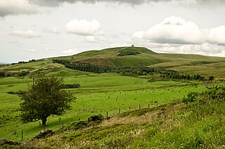
Rivington is a village and civil parish of the Borough of Chorley, Lancashire, England, occupying 2,538 acres. It is about 6 miles (9.7 km) southeast of Chorley and about 8+1⁄2 miles (13.7 km) northwest of Bolton. Rivington is a rural area consisting primarily of agricultural grazing land, moorland, with hill summits including Rivington Pike and Winter Hill within the West Pennine Moors. The area has a thriving tourist industry centred around reservoirs created to serve Liverpool in the Victorian era and Lever Park created as a public park by William Lever at the turn of the 20th century, with two converted barns, a replica of Liverpool Castle and open countryside. Rivington and Blackrod High School is located here. Rivington and its village had a population of 109 at the 2011 Census.

Matthew Claude Mills is an English retired professional footballer who played as a defender.

Embsay is a village in the Craven district of North Yorkshire, England. It is paired with the neighbouring hamlet of Eastby to form the civil parish of Embsay with Eastby. The parish population as of the 2011 census was 1,871.

The West Pennine Moors is an area of the Pennines covering approximately 90 square miles (230 km2) of moorland and reservoirs in Lancashire and Greater Manchester, England. It is a Site of Special Scientific Interest.
The Manchester Bury & Bolton Reservoir, commonly called Elton Reservoir, is located near the A58 Bolton Road in Greater Manchester, about 3 km (1.8 mi) south west of the town of Bury. Constructed in 1842 at the height of the canal era, it remains today as legacy of the industrial era and a major leisure facility for residents of Bury, Bolton and North Manchester.

Llanishen Reservoir is a Victorian reservoir in North Cardiff in Wales. The reservoir is one of the reservoirs constructed as part of the Taff Fawr scheme for supplying water to Cardiff and was completed in 1886. It forms part of the Nant Fawr Corridor from the top of Roath Park to the countryside beyond Cyncoed.
The 2009–10 season was Bolton Wanderers 11th season in the Premier League, and their ninth consecutive season in the top division of English football and covers the period from 1 July 2009 to 30 June 2010. Bolton Wanderers failed to win the 2009–10 Premier League title, making it the 71st time that they have competed at the top level without winning the title, the most of any club.
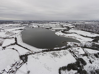
Wayoh Reservoir is a water reservoir in the town of Edgworth, Lancashire, England. It was completed on 28 April 1876 to supply water to Bolton. Wayoh, together with the Turton and Entwistle Reservoir, make up 50% of Bolton's drinking water.

Ward's Reservoir, known locally as the Blue Lagoon, is a small reservoir close to the village of Belmont, Lancashire, England. It is in the West Pennine Moors north of Bolton.

High Rid Reservoir is a small, stone-sided reservoir close to Lostock Junction. It lies three miles to the west of Bolton town centre, Greater Manchester.
Sharples, a suburb of Bolton, was a township of the civil and ecclesiastical parish of Bolton le Moors in the Salford hundred of Lancashire, England. It lay 2½ miles north of Bolton. It contained the smaller settlements of Banktop, Sweet-Loves, High-Houses, Gale, Folds, Belmont, Piccadilly, Water-Meetings, Old Houses and part of Astley Bridge.

