Belston Loch

Last updated

Belston Loch
Belston Loch - geograph.org.uk - 397204.jpg
A view from the centre of Belston Loch
Scotland relief location map.jpg
Red pog.svg
Belston Loch
The location of Belston Loch, East Ayrshire
Location Ochiltree, East Ayrshire, Scotland
Coordinates Coordinates: 55°25′10″N4°24′37″W / 55.41944°N 4.41028°W / 55.41944; -4.41028
Lake type Freshwater loch
Primary inflows Polquharn Burn, rainfall and runoff
Primary outflows Taiglum Burn.
Basin  countriesScotland
Settlements Ochiltree

Belston Loch (NS 34894 16186), also recorded as Dromsmodda Loch [1] is a small freshwater loch in the East Ayrshire Council Area, near Sinclairston, 2 miles south-east of Drongan, lying in a glacial Kettle Hole. [2] Parish of Ochiltree, Scotland.

Contents

The loch

Belston Loch in the 1880 is recorded as being 400m x 300m, the largest of four small lochs, two of them artificial, within the Parish of Ochiltree. [3] Otherwise surrounded by farmland, the south-west area has a few hectares of woodland adjoining the lochshore.

Etymology

Recorded as Drumsmodda Loch in circa 1654, a Drumsmodden Farm is still extant. The Celtic name may survive in the name Polquhairn or Quhairn Pool. [4]

Cartographic evidence

A view looking northeast along the B7046 towards Belston, with Belston Loch at right Belston - geograph.org.uk - 178835.jpg
A view looking northeast along the B7046 towards Belston, with Belston Loch at right

Robert Gordon's map of circa 1636-52 marks the loch and Auchencloigh Castle nearby., [5] located on the Taiglum Burn. Blaeu map of circa 1654 taken from Timothy Pont's map of circa 1600 shows a Drumsmodda Loch (sic) and nearby Auchencloigh Castle (sic) with significant grounds and woodland. A location recorded as Belstain is nearby. [6] Molls map of 1745 shows a single loch that may be Belston. [7] Roy's map of 1747 records the loch position. [8] Armstrong's map of 1775 shows a substantial loch with a Belstoun and a Drumsmiden nearby. [9] In 1821 the loch is clearly shown. [10] In 1832 Thomson's map shows 'Belton Loch' with an inflow burn from Polquhairn. [11]

Uses

The loch is part of Mauchline & Ballochmyle Angling Club; it holds some large rainbow, brown trout, and has some pike. [12]

Curling matches are recorded as having taken place at the loch and a Belston Curling Club existed in the early 20th century. Wattie Young of Polquhairn held the club's minutes book. [1]

Auchencloigh Castle

Auchencloigh Castle or Auchincloigh Castle (NGR NS 4945 1666) is a ruined fortification in the vicinity of Belston Loch near the Burnton Burn, lying within the feudal lands of the Craufurd Clan, situated in the Parish of Ochiltree, East Ayrshire, Scotland.

Micro-history

Fishing club hut Belston Loch, eastern view.jpg
Fishing club hut

The area has seen extensive coal mining activity with an open cast mine and collieries at Drumsmodden, Polquhairn, Old Polquhairn, Auchlin, etc. [2]

George Douglas Brown's father lived at Drumsmodden Farm. George was the author of The House with the Green Shutters'. [2]

Early highways ran close to the loch, as indicated by names such as Glenconner, conaire being a Gaelic word for "path", and there is a farm called Rottenrow near to Glenconner, possibly derived from 'Route de Roi', or King's Highway. [13]

See also

Related Research Articles

<span class="mw-page-title-main">Ochiltree</span> Human settlement in Scotland

Ochiltree is a conservation village in East Ayrshire, Scotland, near Auchinleck and Cumnock. It is one of the oldest villages in East Ayrshire, with archaeological remains indicating Stone Age and Bronze Age settlers. A cinerary urn was found in 1955 during excavation for a new housing estate.

<span class="mw-page-title-main">Lambroughton Loch</span> Body of water

Lambroughton Loch or Wheatrig Loch was situated in a low-lying area between the farms and dwellings of Hillhead, Lambroughton, Wheatrig, Titwood and Lochridge mainly in the Parish of Dreghorn, North Ayrshire. The loch was mainly fed by the Lochridge Burn, the Garrier Burn and surface runoff, such as from the old rig and furrows indicated by Roy's maps of the mid-18th century. The loch outflow was via the Lochridge Burn that runs into the Garrier Burn, passes the site of the old Lochend habitation and into the Bracken Burn near Little Alton. The rivulet or watercourse is known as the Garrier Burn beyond this point.

<span class="mw-page-title-main">Littlestane Loch</span> Former lake in Irvine, Scotland

Littlestane Loch, was situated in the mid-Ayrshire clayland near Stanecastle, Irvine, North Ayrshire, Scotland. It is nowadays (2011) only visible as an area of permanent water in the Scottish Wildlife Trust Sourlie Nature Reserve. The loch was natural, sitting in a hollow created by glaciation. The loch waters outflow was via the Red Burn that flows into the River Garnock. The site of Littlestane Loch site is partly built over and much of the site is now public open space lying within the Parish of Girdle Toll.

<span class="mw-page-title-main">Fail Loch</span> Body of water

Fail Loch or Faile Loch was situated in a low-lying area near the old monastery of Fail in the Parish of Tarbolton, South Ayrshire, Scotland. The old Lochlea Loch lies nearby and its waters still feed into Fail Loch via the Mill Burn.

<span class="mw-page-title-main">Hessilhead Loch</span> Body of water

Hessilhead Loch or Hazelhead Loch was situated in a low-lying area near the old Castle of Hessilhead in the Parish of Beith, North Ayrshire, Scotland. The old loch, used in the defence of the castle, was probably infilled when the castle ruins were landscaped in the 19th century.

<span class="mw-page-title-main">Knockewart Loch</span> Body of water

Knockewart Loch or Loch Jargon was situated in a hollow lying area beneath Knockewart Hill in the Parish of Ardrossan, North Ayrshire, Scotland. The old loch has become largely drained and overgrown since the late 19th century.

<span class="mw-page-title-main">Blae Loch (Beith)</span> A lake in Ayrshire, Scotland

The Blae Loch is a small freshwater loch situated in a hollow in a low-lying area beneath Blaelochhead Hill in the Parish of Beith, North Ayrshire, Scotland.

<span class="mw-page-title-main">Galrigs Loch (South Ayrshire)</span> Body of water

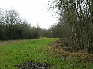
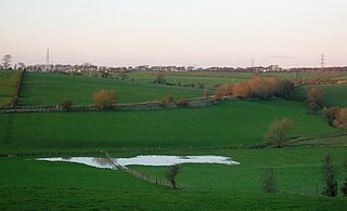
The Galrigs Loch was a substantial freshwater loch situated in low lying area between Newfield and Dundonald in South Ayrshire, Scotland. It was drained in the early 18th century.

<span class="mw-page-title-main">Loch of Trabboch</span> Body of water

The Loch of Trabboch or Dalrympleston Loch (NS440211) was situated in a low-lying area below the old Castle of Trabboch, once held by the Boyd family in the Parish of Stair, East Ayrshire, Scotland.

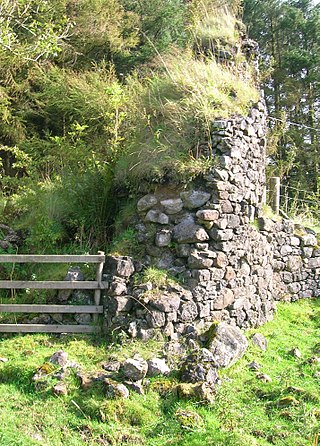
Trabboch Castle is a ruined L-plan tower house in the old Barony of Trabboch, Parish of Stair, East Ayrshire, Scotland.

<span class="mw-page-title-main">Loch of Stair</span> Body of water

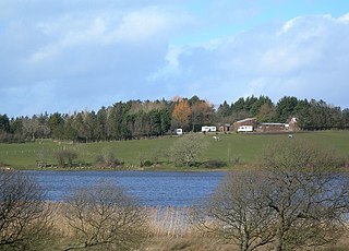
The Loch of Stair was a typical Ayrshire post-glacial 'Kettle Hole', situated in a low-lying area below the farm of Loch Hill, in the Parish of Stair, East Ayrshire, Scotland. This freshwater loch was drained in the 19th century, leaving a wetland area which still periodically floods.

<span class="mw-page-title-main">Martnaham Loch</span> Body of water

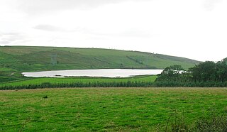
Martnaham Loch is a freshwater loch lying across the border between East and South Ayrshire Council Areas, two kilometres from Coylton, in the parishes of Coylton and Dalrymple, three miles from Ayr. The loch lies along an axis from northeast to southwest. The remains of a castle lie on a possibly artificial islet within the loch. The Campbells of Loudoun once held the lands, followed by the Kennedys of Cassillis.

<span class="mw-page-title-main">Carcluie Loch</span> Body of water

Carcluie Loch is a small freshwater loch in the South Ayrshire Council Area, lying in a glacial Kettle Hole, Parish of Dalrymple, Scotland.

<span class="mw-page-title-main">Kerse Loch</span> Body of water

Kerse Loch, also recorded as Carse Loch (1841) is a small freshwater loch in the East Ayrshire Council Area, lying in a glacial Kettle Hole, Parish of Dalrymple, Scotland.

<span class="mw-page-title-main">Auchenbathie Tower</span>

Auchenbathie, Auchinbathie Tower or rarely Barcraigs Tower is a ruined fortification, a tower house, once held by the Wallace Clan of Elderslie, situated in Renfrewshire, Parish of Lochwinnoch, Scotland. The spelling used varies greatly and "Auchenbathie" will be used here as the standard spelling. The pronunciation locally is "Auchenbothy", the same as a Victorian mansion in Kilmacolm; no connection is known.

<span class="mw-page-title-main">Auchencloigh Castle</span> Ruined fortification in the Parish of Ochiltree, East Ayrshire, Scotland

Auchencloigh Castle or Auchincloigh Castle is a ruined fortification near the Burnton Burn, lying within the feudal lands of the Craufurd Clan, situated in the Parish of Ochiltree, East Ayrshire, Scotland.

Plaid Loch was a freshwater loch in East Ayrshire, now a remnant due to drainage, near Sinclairston and 2 miles (3 km) south-east of Drongan, lying in a glacial kettle hole,.

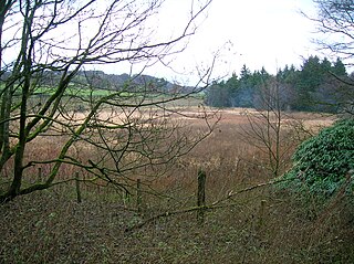
South Palmerston Loch or Flush, previously known as Loch of the Hill, lying to the east of the 500 ft Back hill Mount. It was one of several small lochs within the Parish of Ochiltree. The loch, lying in a glacial kettle hole, drained into the Lugar Water via the Burnock Water.

<span class="mw-page-title-main">Loch Shield</span> Body of water

Loch Shield, originally Loch of Scheel was a freshwater loch in the East Ayrshire Council Area, now drained, near Drongan, lying in a glacial Kettle Hole, Parish of Ochiltree, Scotland.

<span class="mw-page-title-main">Whitehill Loch</span> Body of water

Whitehill Loch, previously known as Hillhouse Loch was a freshwater loch in the East Ayrshire Council Area, now drained, near Galston, in the Parish of Riccarton, lying in a glacial Kettle Hole.

References

Notes

  1. 1 2 Curling Pond Sites retrieved : 2011-11-11
  2. 1 2 3 Love, Page 197
  3. Vision of Britain Retrieved : 2011-11-11
  4. Ayrshire Roots Retrieved : 2011-11-11
  5. Gordon's Map Retrieved : 2011-11-11
  6. Blaeu's Map Retrieved : 2011-11-11
  7. Moll's Map Retrieved : 2011-11-11
  8. Roy's Map retrieved : 2011-11-11
  9. Armstrong's Map Retrieved : 2011-11-11
  10. Ainslie Retrieved : 2011-11-11
  11. Thomson's Map Retrieved : 2011-11-11
  12. Fly Fishing Forum Archived March 11, 2012, at the Wayback Machine Retrieved : 2011-11-11
  13. Old Roads of Scotland Retrieved : 2011-11-11

Sources

  1. Love, Dane (2003). Ayrshire : Discovering a County. Ayr : Fort Publishing. ISBN   0-9544461-1-9.