
Erosion is the action of surface processes that removes soil, rock, or dissolved material from one location on the Earth's crust and then transports it to another location where it is deposited. Erosion is distinct from weathering which involves no movement. Removal of rock or soil as clastic sediment is referred to as physical or mechanical erosion; this contrasts with chemical erosion, where soil or rock material is removed from an area by dissolution. Eroded sediment or solutes may be transported just a few millimetres, or for thousands of kilometres.

A valley is an elongated low area often running between hills or mountains, which typically contains a river or stream running from one end to the other. Most valleys are formed by erosion of the land surface by rivers or streams over a very long period. Some valleys are formed through erosion by glacial ice. These glaciers may remain present in valleys in high mountains or polar areas.

An entrenched river, or entrenched stream is a river or stream that flows in a narrow trench or valley cut into a plain or relatively level upland. Because of lateral erosion streams flowing over gentle slopes over a time develops meandering course. Meanders form where gradient is very gentle, for example in floodplain and delta. Meandering is the feature of the middle and final course of the river. But very deep and wide meanders can also be found cutting hard rocks. Such meanders are called incised or entrenched meanders. The exception is that entrenched meanders are formed during the upliftment of land where river is young. They widen and deepen over time and can be found as deep gorges or canyons in hard rock. In the case of an entrenched stream or river, it is often presumed that the watercourse has inherited its course by cutting down into bedrock from a pre-existing plain with little modification of the original course. The down-cutting of the river system could be the result not only of tectonic uplift but also of other factors such as river piracy, decrease of load, increase of runoff, extension of the drainage basin, or change in base level such as a fall in sea level. General, nongeneric terminology for either a river or stream that flows in a narrow trench or valley, for which evidence of a preexisting plain or relatively level upland can be either absent or present is either valley meander or meander valley with the latter term being preferred in literature.

Geomorphology is the scientific study of the origin and evolution of topographic and bathymetric features generated by physical, chemical or biological processes operating at or near Earth's surface. Geomorphologists seek to understand why landscapes look the way they do, to understand landform and terrain history and dynamics and to predict changes through a combination of field observations, physical experiments and numerical modeling. Geomorphologists work within disciplines such as physical geography, geology, geodesy, engineering geology, archaeology, climatology, and geotechnical engineering. This broad base of interests contributes to many research styles and interests within the field.

A landform is a natural or anthropogenic land feature on the solid surface of the Earth or other planetary body. Landforms together make up a given terrain, and their arrangement in the landscape is known as topography. Landforms include hills, mountains, canyons, and valleys, as well as shoreline features such as bays, peninsulas, and seas, including submerged features such as mid-ocean ridges, volcanoes, and the great ocean basins.

In oceanography, geomorphology, and geoscience, a shoal is a natural submerged ridge, bank, or bar that consists of, or is covered by, sand or other unconsolidated material, and rises from the bed of a body of water close to the surface or above it, which poses a danger to navigation. Shoals are also known as sandbanks, sandbars, or gravelbars. Two or more shoals that are either separated by shared troughs or interconnected by past or present sedimentary and hydrographic processes are referred to as a shoal complex.
Landforms are categorized by characteristic physical attributes such as their creating process, shape, elevation, slope, orientation, rock exposure, and soil type.
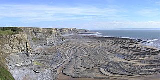
A wave-cut platform, shore platform, coastal bench, or wave-cut cliff is the narrow flat area often found at the base of a sea cliff or along the shoreline of a lake, bay, or sea that was created by erosion. Wave-cut platforms are often most obvious at low tide when they become visible as huge areas of flat rock. Sometimes the landward side of the platform is covered by sand, forming the beach, and then the platform can only be identified at low tides or when storms move the sand.
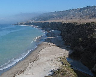
A raised beach, coastal terrace, or perched coastline is a relatively flat, horizontal or gently inclined surface of marine origin, mostly an old abrasion platform which has been lifted out of the sphere of wave activity. Thus, it lies above or under the current sea level, depending on the time of its formation. It is bounded by a steeper ascending slope on the landward side and a steeper descending slope on the seaward side. Due to its generally flat shape, it is often used for anthropogenic structures such as settlements and infrastructure.

A gully is a landform created by running water, mass movement, or commonly a combination of both eroding sharply into soil or other relatively erodible material, typically on a hillside or in river floodplains or terraces. Gullies resemble large ditches or small valleys, but are metres to tens of metres in depth and width, are characterized by a distinct 'headscarp' or 'headwall' and progress by headward erosion. Gullies are commonly related to intermittent or ephemeral water flow, usually associated with localised intense or protracted rainfall events or snowmelt. Gullies can be formed and accelerated by cultivation practices on hillslopes in farmland, and they can develop rapidly in rangelands from existing natural erosion forms subject to vegetative cover removal and livestock activity.
A kame, or knob, is a glacial landform, an irregularly shaped hill or mound composed of sand, gravel and till that accumulates in a depression on a retreating glacier, and is then deposited on the land surface with further melting of the glacier. Kames are often associated with kettles, and this is referred to as kame and kettle or knob and kettle topography. The word kame is a variant of comb, which has the meaning "crest" among others. The geological term was introduced by Thomas Jamieson in 1874.

A ridge is a long, narrow, elevated geomorphologic landform, structural feature, or a combination of both separated from the surrounding terrain by steep sides. The sides of a ridge slope away from a narrow top, the crest or ridgecrest, with the terrain dropping down on either side. The crest, if narrow, is also called a ridgeline. Limitations on the dimensions of a ridge are lacking. Its height above the surrounding terrain can vary from less than a meter to hundreds of meters. A ridge can be either depositional, erosional, tectonic, or a combination of these in origin and can consist of either bedrock, loose sediment, lava, or ice depending on its origin. A ridge can occur as either an isolated, independent feature or part of a larger geomorphological and/or structural feature. Frequently, a ridge can be further subdivided into smaller geomorphic or structural elements.

Surface mining, including strip mining, open-pit mining and mountaintop removal mining, is a broad category of mining in which soil and rock overlying the mineral deposit are removed, in contrast to underground mining, in which the overlying rock is left in place, and the mineral is removed through shafts or tunnels.
Fluvial terraces are elongated terraces that flank the sides of floodplains and fluvial valleys all over the world. They consist of a relatively level strip of land, called a "tread", separated from either an adjacent floodplain, other fluvial terraces, or uplands by distinctly steeper strips of land called "risers". These terraces lie parallel to and above the river channel and its floodplain. Because of the manner in which they form, fluvial terraces are underlain by fluvial sediments of highly variable thickness. River terraces are the remnants of earlier floodplains that existed at a time when either a stream or river was flowing at a higher elevation before its channel downcut to create a new floodplain at a lower elevation. Changes in elevation can be due to changes in the base level of the fluvial system, which leads to headward erosion along the length of either a stream or river, gradually lowering its elevation. For example, downcutting by a river can lead to increased velocity of a tributary, causing that tributary to erode toward its headwaters. Terraces can also be left behind when the volume of the fluvial flow declines due to changes in climate, typical of areas which were covered by ice during periods of glaciation, and their adjacent drainage basins.

In geology, a terrace is a step-like landform. A terrace consists of a flat or gently sloping geomorphic surface, called a tread, that is typically bounded on one side by a steeper ascending slope, which is called a "riser" or "scarp". The tread and the steeper descending slope together constitute the terrace. Terraces can also consist of a tread bounded on all sides by a descending riser or scarp. A narrow terrace is often called a bench.

The Geology of Pennsylvania consists of six distinct physiographic provinces, three of which are subdivided into different sections. Each province has its own economic advantages and geologic hazards and plays an important role in shaping everyday life in the state. From the southeast corner to the northwest corner of the state, they include: the Atlantic Plain Province, the Piedmont Province, the New England Province, the Ridge and Valley Province, the Appalachain Province, and the Central Lowlands Province.

In geology and geomorphology, a hogback or hog's back is a long, narrow ridge or a series of hills with a narrow crest and steep slopes of nearly equal inclination on both flanks. Typically, the term is restricted to a ridge created by the differential erosion of outcropping, steeply dipping, homoclinal, and typically sedimentary strata. One side of a hogback consists of the surface of a steeply dipping rock stratum called a dip slope. The other side is an erosion face that cuts through the dipping strata that comprises the hogback. The name "hogback" comes from the Hog's Back of the North Downs in Surrey, England, which refers to the landform's resemblance in outline to the back of a hog. The term is also sometimes applied to drumlins and, in Maine, to both eskers and ridges known as "horsebacks".

In structural geology, a homocline or homoclinal structure, is a geological structure in which the layers of a sequence of rock strata, either sedimentary or igneous, dip uniformly in a single direction having the same general inclination in terms of direction and angle. A homocline can be associated with either one limb of a fold, the edges of a dome, the coast-ward tilted strata underlying a coastal plain, slice of thrust fault, or a tilted fault block. When the homoclinal strata consists of alternating layers of rock that vary hardness and resistance to erosion, their erosion produces either cuestas, homoclinal ridges, or hogbacks depending on the angle of dip of the strata. On a topographic map, the landfroms associated with homoclines exhibit nearly parallel elevation contour lines that show a steady change in elevation in a given direction. In the subsurface, they characterize by parallel structural contour lines.
This glossary of geography terms is a list of definitions of terms and concepts used in geography and related fields, including Earth science, oceanography, cartography, and human geography, as well as those describing spatial dimension, topographical features, natural resources, and the collection, analysis, and visualization of geographic data. It is split across two articles:

Terraces can be formed in many ways and in several geologic and environmental settings. By studying the size, shape, and age of terraces, one can determine the geologic processes that formed them. When terraces have the same age and/or shape over a region, it is often indicative that a large-scale geologic or environmental mechanism is responsible. Tectonic uplift and climate change are viewed as dominant mechanisms that can shape the earth’s surface through erosion. River terraces can be influenced by one or both of these forcing mechanisms and therefore can be used to study variation in tectonics, climate, and erosion, and how these processes interact.
