
The Presidio of San Francisco is a park and former U.S. Army post on the northern tip of the San Francisco Peninsula in San Francisco, California, and is part of the Golden Gate National Recreation Area.

Marin County is located in the northwestern part of the San Francisco Bay Area of the U.S. state of California. As of the 2020 census, the population was 262,231. Its county seat and largest city is San Rafael. Marin County is across the Golden Gate Bridge from San Francisco, and is included in the San Francisco–Oakland–Berkeley, CA Metropolitan Statistical Area.

Belvedere is a residential incorporated city located on the San Francisco Bay in Marin County, California, United States. Consisting of two islands and a lagoon, it is connected to the Tiburon Peninsula by two causeways. At the 2020 census, the population was 2,126. The per-capita income of Belvedere residents in the year 2000 was $250,000, but currently the average income is $283,000, making it one of the highest-income cities in California and the eighth highest-income community in the United States. Belvedere and Tiburon share a post office and the 94920 ZIP code.

Mill Valley is a city in Marin County, California, United States, located about 14 miles (23 km) north of San Francisco via the Golden Gate Bridge and 52 miles (84 km) from Napa Valley. The population was 14,231 at the 2020 census.
Strawberry is a census-designated place (CDP) and an unincorporated district of Marin County, California, United States. It shares a ZIP code (94941) with Mill Valley and falls within its school districts; however, it is considered within the sphere of influence of the town of Tiburon. It is separated from Mill Valley by U.S. Route 101. Its population was 5,447 at the 2020 census.

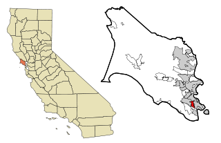
Tiburon is an incorporated town in Marin County, California. It is located on the Tiburon Peninsula, which reaches south into the San Francisco Bay. It shares a ZIP code (94920) with the smaller incorporated city of Belvedere, which occupies the southwest part of the peninsula and is contiguous with Tiburon. Tiburon is bordered by Corte Madera to the north and Mill Valley to the west, but is otherwise mostly surrounded by the bay. Besides Belvedere and Tiburon, much of the peninsula is unincorporated, including portions of the north side and the communities of Strawberry and Paradise Cay.

The Rengstorff House was one of the first houses to be built in Mountain View, California. It was built c. 1867 by Henry Rengstorff, a prominent local businessman who operated a ferry between San Francisco and Mountain View. It is built in the Italianate Victorian architecture style. The house's three-bay front facade features an entrance pavilion topped by a balustrade and a pediment on the middle bay.

The Golden Gate Biosphere Network is a voluntary coalition of federal, state, and local government agencies, nonprofit organizations, universities, and private partners within the Golden Gate Biosphere region. The Network works towards protecting the biosphere region's biodiversity and conserving its natural resources to maintain the quality of life for people within the region. The Network has been part of the UNESCO Man and Biosphere Programme since 1988 and is part of the US Biosphere Network and EuroMAB. It is recognized by UNESCO due to the significant biodiversity of the region, as well as the Network's efforts to demonstrate and promote a balanced relationship between humans and the biosphere.
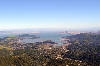
Richardson Bay is a shallow, ecologically rich arm of San Francisco Bay, managed under a Joint Powers Agency of four northern California cities. The 911-acre (369 ha) Richardson Bay Sanctuary was acquired in the early 1960s by the National Audubon Society. The bay was named for William A. Richardson, early 19th century sea captain and builder in San Francisco. It contains both Strawberry Spit and Aramburu Island.

Arroyo Corte Madera del Presidio is a 4.1-mile-long (6.6 km) year-round stream in southern Marin County, California, United States. This watercourse is also known as Corte Madera Creek, although the actual stream of that name flows into San Francisco Bay further north at Point San Quentin. This watercourse has a catchment basin of about 8 square miles (21 km2) and drains the south-eastern slopes of Mount Tamalpais and much of the area in and around the town of Mill Valley; this stream discharges to Richardson Bay.
Bothin Marsh is a 106 acres (43 ha) wetland in Marin County, California. Parts of the wetlands are in the Bothin Marsh Open Space Preserve, a regional park.

Belvedere Island is a rocky island in the San Francisco Bay in Marin County, California which was formerly separated by a marsh from the mainland, though has since been linked by two spits. Part of the town of Belvedere, California is located on the island.

Triangle Marsh is a wetland of the San Francisco Bay, situated at the base of Ring Mountain at the north end of the Tiburon Peninsula in Marin County, California.
John Thomas Reed was an early California European settler who was the grantee of Rancho Corte Madera del Presidio in what is now Marin County, California.
Tamalpais Valley is an unincorporated community in Marin County, California.
Rancho Corte Madera del Presidio was a 7,845-acre (31.75 km2) Mexican land grant in present day Marin County, California given in 1834 by Governor José Figueroa to John (Juan) Reed. Corte Madera del Presidio means the "lumber mill of the Presidio". The grant encompassed what is now southern Corte Madera, Mill Valley, the Tiburon Peninsula, and Strawberry Point. It reached from Point Tiburon to Larkspur Creek, then known as Arroyo Holon.

The Carson Mansion is a large Victorian house located in Old Town, Eureka, California. Regarded as one of the premier examples of Queen Anne style architecture in the United States, the house is "considered the most grand Victorian home in America." It is one of the most written about and photographed Victorian houses in California and possibly also in the United States.
Caroline Sealy Livermore was an American conservationist with emphasis in environment planning and protection. Livermore was mostly in the San Francisco Bay Area in both Marin County and the shore areas, during the 20th century. She pursued her conservation efforts over a period of 15 years where she interacted with national and state level lawmakers. Her work led to the protection of Angel Island and its declaration as a state park. Consequently, the highest mountain on the Angel Island was named Mount Livermore in her honor.

Old Mill Creek is a 2.3-mile-long (3.7 km) year-round stream in southern Marin County, California, United States. Old Mill Creek is a tributary to Arroyo Corte Madera del Presidio, which, in turn, flows to Richardson Bay at Mill Valley's municipal Bayfront Park and 106 acres (0.43 km2) Bothin Marsh.


