Benkelman, Nebraska

Last updated

Benkelman, Nebraska
Dundy County, Nebraska courthouse from SE 1.jpg
Courthouse square (2011)
Dundy County Nebraska Incorporated and Unincorporated areas Benkelman Highlighted.svg
Location within Dundy County and Nebraska
Coordinates: 40°02′49″N101°32′25″W / 40.04694°N 101.54028°W / 40.04694; -101.54028 [1]
CountryUnited States
State Nebraska
County Dundy
Area
[2]
  Total1.20 sq mi (3.11 km2)
  Land1.20 sq mi (3.11 km2)
  Water0.00 sq mi (0.00 km2)
Elevation
[1]
3,041 ft (927 m)
Population
 (2020)
  Total821
  Density684.74/sq mi (264.32/km2)
Time zone UTC-7 (Mountain (MST))
  Summer (DST) UTC-6 (MDT)
ZIP code
69021
Area code 308
FIPS code 31-04230
GNIS ID 2394133 [1]
Website benkelmanusa.com

Benkelman is a city in and the county seat of Dundy County, Nebraska, United States. [1] As of the 2020 census, the city population was 821. [3]

Contents

History

Benkelman was originally called Collinsville, in honor of Moses Collins, and under that name was founded circa 1880. [4] In 1882, it was renamed Benkelman by the railroad for J. G. Benkelman, a stock raiser. [5]

Geography

According to the United States Census Bureau, the city has a total area of 0.80 square miles (2.07 km2), all land. [6]

Climate

Climate data for Benkelman, Nebraska (1991–2020)
MonthJanFebMarAprMayJunJulAugSepOctNovDecYear
Mean daily maximum °F (°C)42.5
(5.8)
45.8
(7.7)
56.5
(13.6)
64.6
(18.1)
74.0
(23.3)
85.8
(29.9)
91.4
(33.0)
89.0
(31.7)
81.4
(27.4)
67.7
(19.8)
54.0
(12.2)
43.5
(6.4)
66.4
(19.1)
Mean daily minimum °F (°C)15.9
(−8.9)
18.6
(−7.4)
27.2
(−2.7)
36.1
(2.3)
47.4
(8.6)
58.4
(14.7)
64.0
(17.8)
61.5
(16.4)
51.4
(10.8)
37.0
(2.8)
25.4
(−3.7)
16.9
(−8.4)
38.3
(3.5)
Average precipitation inches (mm)0.51
(13)
0.60
(15)
0.97
(25)
1.96
(50)
3.11
(79)
2.90
(74)
3.13
(80)
2.39
(61)
1.44
(37)
1.50
(38)
0.60
(15)
0.55
(14)
19.66
(499)
Average snowfall inches (cm)5.6
(14)
5.9
(15)
4.0
(10)
2.5
(6.4)
0.1
(0.25)
0.0
(0.0)
0.0
(0.0)
0.0
(0.0)
0.2
(0.51)
1.9
(4.8)
2.6
(6.6)
4.8
(12)
27.6
(70)
Source: NOAA [7]

Demographics

Historical population
CensusPop.Note
1890 357
1900 296−17.1%
1910 53881.8%
1920 1,00987.5%
1930 1,15414.4%
1940 1,44825.5%
1950 1,5124.4%
1960 1,400−7.4%
1970 1,349−3.6%
1980 1,235−8.5%
1990 1,193−3.4%
2000 1,006−15.7%
2010 953−5.3%
2020 821−13.9%
U.S. Decennial Census

2010 census

As of the census [8] of 2010, there were 953 people, 445 households, and 242 families residing in the city. The population density was 1,191.3 inhabitants per square mile (460.0/km2). There were 556 housing units at an average density of 695.0 per square mile (268.3/km2). The racial makeup of the city was 95.9% White, 0.4% African American, 0.8% Native American, 0.2% Asian, 0.7% from other races, and 1.9% from two or more races. Hispanic or Latino of any race were 4.4% of the population.

There were 445 households, of which 23.6% had children under the age of 18 living with them, 44.9% were married couples living together, 6.7% had a female householder with no husband present, 2.7% had a male householder with no wife present, and 45.6% were non-families. 42.5% of all households were made up of individuals, and 22% had someone living alone who was 65 years of age or older. The average household size was 2.07 and the average family size was 2.86.

The median age in the city was 48.5 years. 22.4% of residents were under the age of 18; 3.7% were between the ages of 18 and 24; 19.2% were from 25 to 44; 29.4% were from 45 to 64; and 25.4% were 65 years of age or older. The gender makeup of the city was 46.6% male and 53.4% female.

2000 census

As of the census [9] of 2000, there were 1,006 people, 458 households, and 266 families residing in the city. The population density was 1,267.6 inhabitants per square mile (489.4/km2). There were 576 housing units at an average density of 725.8 per square mile (280.2/km2). The racial makeup of the city was 97.51% White, 0.80% Native American, 0.60% Asian, 0.10% Pacific Islander, 0.10% from other races, and 0.89% from two or more races. Hispanic or Latino of any race were 0.30% of the population.

There were 458 households, out of which 24.0% had children under the age of 18 living with them, 51.3% were married couples living together, 5.5% had a female householder with no husband present, and 41.9% were non-families. 38.6% of all households were made up of individuals, and 24.7% had someone living alone who was 65 years of age or older. The average household size was 2.07 and the average family size was 2.76.

In the city, the population was spread out, with 20.0% under the age of 18, 5.9% from 18 to 24, 21.1% from 25 to 44, 23.4% from 45 to 64, and 29.7% who were 65 years of age or older. The median age was 47 years. For every 100 females, there were 79.3 males. For every 100 females age 18 and over, there were 75.0 males.

As of 2000 the median income for a household in the city was $27,788, and the median income for a family was $37,813. Males had a median income of $26,741 versus $19,107 for females. The per capita income for the city was $16,700. About 7.4% of families and 11.9% of the population were below the poverty line, including 15.2% of those under age 18 and 8.0% of those age 65 or over.

Transportation

Major highways

Rail

The BNSF Railroad passes through Benkelman from east to west generally following the Republican River. US 34 follows this general alignment as well. Amtrak passes through town, although there is no station in town. The nearest is McCook station an hour to the east.

Notable people

See also

Related Research Articles

<span class="mw-page-title-main">Dundy County, Nebraska</span> County in Nebraska, United States

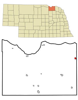
Dundy County is a county in the U.S. state of Nebraska. As of the 2020 United States Census, the population was 1,654. Its county seat is Benkelman.

<span class="mw-page-title-main">Holstein, Nebraska</span> Village in Adams County, Nebraska, United States

Holstein is a village in Adams County, Nebraska, United States. The population was 188 at the 2020 census. It is part of the Hastings, Nebraska Micropolitan Statistical Area.

<span class="mw-page-title-main">Cedar Creek, Nebraska</span> Village in Nebraska, United States

Cedar Creek is a village in Cass County, Nebraska, United States. The population was 465 at the 2020 census.

<span class="mw-page-title-main">Mason City, Nebraska</span> Village in Nebraska, United States

Mason City is a village in Custer County, Nebraska, United States. The population was 171 at the 2010 census.

<span class="mw-page-title-main">Dakota City, Nebraska</span> City in Dakota County, Nebraska, United States

Dakota City is a city in Dakota County, Nebraska, United States. The population was 1,919 at the 2010 census. It is the county seat of Dakota County. Tyson Foods' largest beef production plant is located in Dakota City.

<span class="mw-page-title-main">Boys Town, Nebraska</span> Village in Douglas County, Nebraska, United States

Boys Town is a village in Douglas County, Nebraska, United States. The population was 410 at the 2020 census. Boys Town is an enclave and a suburb of Omaha.

<span class="mw-page-title-main">Waterloo, Nebraska</span> Village in Douglas County, Nebraska, United States

Waterloo is a village in Douglas County, Nebraska, United States. The population was 935 at the 2020 census.

<span class="mw-page-title-main">Haigler, Nebraska</span> Village in Dundy County, Nebraska, United States

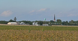
Haigler is a village in southwestern Dundy County, Nebraska, United States. The population was 158 at the 2010 census.

<span class="mw-page-title-main">Beaver City, Nebraska</span> City in Nebraska, United States

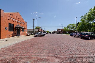
Beaver City is a city in Furnas County, on the southern border of Nebraska, United States. The population was 609 at the 2010 census. It is the county seat of Furnas County.

<span class="mw-page-title-main">Wood River, Nebraska</span> Village in Hall County, Nebraska, United States

Wood River is a city in southwestern Hall County, Nebraska, United States. The population was 1,172 at the 2020 census. It is part of the Grand Island, Nebraska Metropolitan Statistical Area.

<span class="mw-page-title-main">Crofton, Nebraska</span> City in Nebraska, United States

Crofton is a city in Knox County, Nebraska, United States. The population was 726 at the 2010 census.

<span class="mw-page-title-main">Waverly, Nebraska</span> Village in Nebraska, United States

Waverly is a village in Lancaster County, Nebraska, United States. It is part of the Lincoln, Nebraska Metropolitan Statistical Area. The population was 4,279 at the 2020 census.

<span class="mw-page-title-main">Osmond, Nebraska</span> City in Nebraska, United States

Osmond is a city in Pierce County, Nebraska, United States. It is part of the Norfolk, Nebraska Micropolitan Statistical Area. The population was 791 at the 2020 census.

<span class="mw-page-title-main">Humphrey, Nebraska</span> City in Platte County, Nebraska, United States

Humphrey is a city in Platte County, Nebraska, United States. The population was 760 at the 2010 census.

<span class="mw-page-title-main">Crete, Nebraska</span> City in Saline County, Nebraska, United States

Crete is a city in and the most populous municipality of Saline County, Nebraska, United States. The population was 7,099 at the 2020 census. The city is home to Doane University.

<span class="mw-page-title-main">Gretna, Nebraska</span> City in Sarpy County, Nebraska, United States

Gretna is a city in Sarpy County, Nebraska, United States. The population was 5,083 at the 2020 census.

<span class="mw-page-title-main">Valparaiso, Nebraska</span> Village in Saunders County, Nebraska, United States

Valparaiso is a village in Saunders County, Nebraska, United States. The population was 595 at the 2020 census.

<span class="mw-page-title-main">Winnebago, Nebraska</span> Village in Thurston County, Nebraska, United States

Winnebago is a village in Thurston County, Nebraska, United States. The population was 916 at the 2020 census.

<span class="mw-page-title-main">Blair, Nebraska</span> City in and county seat of Washington County, Nebraska, United States

Blair is a city in and the county seat of Washington County, Nebraska, United States. The population was 7,990 at the 2010 census. Blair is a part of the Omaha-Council Bluffs Metropolitan Statistical Area.

<span class="mw-page-title-main">Kennard, Nebraska</span> Village in Washington County, Nebraska, United States

Kennard is a village in Washington County, Nebraska, United States. The population was 361 at the 2010 census.

References

  1. 1 2 3 4 U.S. Geological Survey Geographic Names Information System: Benkelman, Nebraska
  2. "ArcGIS REST Services Directory". United States Census Bureau. Retrieved September 18, 2022.
  3. "2020 City Population and Housing Occupancy Status". U.S. Census Bureau. Retrieved April 30, 2022.[ dead link ]
  4. Burr, George L. (1921). History of Hamilton and Clay Counties, Nebraska, Volume 1. S.J. Clarke Publishing Company. p. 109.
  5. "Benkelman, Dundy County". Center for Advanced Land Management Information Technologies. University of Nebraska. Archived from the original on October 31, 2013. Retrieved August 8, 2014.
  6. "US Gazetteer files 2010". United States Census Bureau. Archived from the original on July 2, 2012. Retrieved June 24, 2012.
  7. "NOWData - NOAA Online Weather Data". National Oceanic and Atmospheric Administration . Retrieved February 7, 2023.
  8. "U.S. Census website". United States Census Bureau . Retrieved June 24, 2012.
  9. "U.S. Census website". United States Census Bureau . Retrieved January 31, 2008.