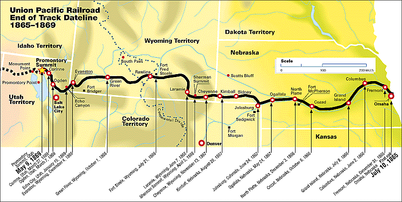
Ogallala first was founded as a terminus for cattle drives that traveled from Texas to the Union Pacific railhead located there. These trails are known as the Western or Great Western trails.[4][5] The Union Pacific Railroad reached Ogallala on May 24, 1867.[6] The city itself was not laid out until 1875 and not incorporated until 1884[7] The town's name comes from the Oglala Sioux tribe.[8] Rowdy cowboys made this a dangerous place to be during the cattle drive months resulting in Ogallala getting a reputation as both "The Town Too Tough For Texas" and "Gomorrah of the West"[9]
Geography
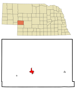
According to the United States Census Bureau, the city has a total area of 5.02 square miles (13.00km2), of which 4.96 square miles (12.85km2) is land and 0.06 square miles (0.16km2) is water.[10] Ogallala is in the US Mountain Time Zone (UTC−7/-6).
Ogallala is close to Lake McConaughy, a large man-made lake and a state recreation area with sandy beaches, boating and swimming. The South Platte River runs through Ogallala.
Ogallala has a dry humid subtropical climate (KöppenCfa), bordering on cold semi-arid and a humid continental climate (Köppen Dfa) with an annual average precipitation of 20.40in (518mm). Winters are cold, while summers are hot and often stormy. Precipitation is greatest in the late spring and summer, with winter being the driest part of the year.
Climate data for Ogallala, Nebraska (1991–2020 normals, extremes 1893–present)
The 2020 United States census[15] counted 4,878 people, 2,300 households, and 1,082 families in Ogallala. The population density was 983.5 per square mile (379.9/km2). There were 2,429 housing units at an average density of 489.7 per square mile (189.2/km2). The racial makeup was 88.42% (4,313) white, 0.37% (18) black or African-American, 0.47% (23) Native American, 0.55% (27) Asian, 0.1% (5) Pacific Islander, 3.87% (189) from other races, and 6.21% (303) from two or more races. Hispanic or Latino of any race was 9.0% (436) of the population.
Of the 2,300 households, 22.5% had children under the age of 18; 36.2% were married couples living together; 31.2% had a female householder with no husband present. 44.3% of households consisted of individuals and 20.5% had someone living alone who was 65 years of age or older. The average household size was 1.9 and the average family size was 2.7.
19.6% of the population was under the age of 18, 5.9% from 18 to 24, 22.1% from 25 to 44, 23.3% from 45 to 64, and 21.5% who were 65 years of age or older. The median age was 43.5 years. For every 100 females, the population had 94.4 males. For every 100 females ages 18 and older, there were 94.3 males.
The 2016-2020 5-year American Community Survey[16] estimates show that the median household income was $45,508 (with a margin of error of +/- $8,969) and the median family income $61,422 (+/- $6,719). Males had a median income of $37,220 (+/- $7,286) versus $26,419 (+/- $2,208) for females. The median income for those above 16 years old was $31,090 (+/- $3,246). Approximately, 12.1% of families and 20.7% of the population were below the poverty line, including 24.5% of those under the age of 18 and 23.2% of those ages 65 or over.
2010 census
As of the census[17] of 2010, there were 4,737 people, 2,100 households, and 1,298 families living in the city. The population density was 955.0 inhabitants per square mile (368.7/km2). There were 2,397 housing units at an average density of 483.3 per square mile (186.6/km2). The racial makeup of the city was 94.6% White, 0.2% African American, 0.6% Native American, 0.4% Asian, 2.2% from other races, and 2.0% from two or more races. Hispanic or Latino of any race were 7.5% of the population.
There were 2,100 households, of which 27.5% had children under the age of 18 living with them, 48.0% were married couples living together, 9.6% had a female householder with no husband present, 4.2% had a male householder with no wife present, and 38.2% were non-families. 34.1% of all households were made up of individuals, and 14.6% had someone living alone who was 65 years of age or older. The average household size was 2.23 and the average family size was 2.85.
The median age in the city was 43.7 years. 23.6% of residents were under the age of 18; 6.8% were between the ages of 18 and 24; 21.4% were from 25 to 44; 28.3% were from 45 to 64; and 20.1% were 65 years of age or older. The gender makeup of the city was 48.8% male and 51.2% female.
2000 census
As of the census of 2000, there were 4,930 people, 2,052 households, and 1,339 families living in the city. The population density was 1,472.4 inhabitants per square mile (568.5/km2). There were 2,314 housing units at an average density of 691.1 per square mile (266.8/km2). The racial makeup of the city was 96.45% White, 0.02% African American, 0.87% Native American, 0.22% Asian, 1.68% from other races, and 0.75% from two or more races. Hispanic or Latino of any race were 4.79% of the population.
There were 2,052 households, out of which 31.5% had children under the age of 18 living with them, 53.0% were married couples living together, 9.5% had a female householder with no husband present, and 34.7% were non-families. 30.7% of all households were made up of individuals, and 14.7% had someone living alone who was 65 years of age or older. The average household size was 2.35 and the average family size was 2.94.
In the city, the population was spread out, with 26.5% under the age of 18, 6.7% from 18 to 24, 26.5% from 25 to 44, 21.9% from 45 to 64, and 18.4% who were 65 years of age or older. The median age was 39 years. For every 100 females, there were 89.0 males. For every 100 females age 18 and over, there were 85.0 males.
As of 2000 the median income for a household in the city was $32,141, and the median income for a family was $39,688. Males had a median income of $27,436 versus $18,292 for females. The per capita income for the city was $17,674. About 5.0% of families and 7.8% of the population were below the poverty line, including 9.3% of those under age 18 and 9.1% of those age 65 or over.
↑Seltzer, Leon, ed. (1952), "Ogallala, Nebraska", Columbia Lippincott Gazetteer of the world: Lippincott's pronouncing gazetteer, New York: Columbia University Press, p.1378
↑"history of ogallala..."Official Website, City of Ogallala. City of Ogallala. Archived from the original on May 17, 2012. Retrieved August 19, 2012.
↑"Station: Ogallala, NE". U.S. Climate Normals 2020: U.S. Monthly Climate Normals (1991–2020). National Oceanic and Atmospheric Administration. Retrieved November 29, 2021.
This page is based on this Wikipedia article Text is available under the CC BY-SA 4.0 license; additional terms may apply. Images, videos and audio are available under their respective licenses.


